(1) Description: Suction dredging projects excavate, process, and classify aggregate using small motorized or nonmotorized equipment that removes aggregate from the bed, banks, or uplands by means of vacuum created by water flowing through a tube or hose. Bulb snifters are not considered suction dredges. The rules in this section apply to using motorized and nonmotorized suction dredges. See WAC 220-660-300 for mineral prospecting with equipment other than suction dredges.
(2) Fish life concerns: Suction dredging can harm fish life and habitat that supports fish life.
(a) Direct impacts from suction dredging can include:
(i) Mortality from the physical effects of disturbing eggs or fry incubating within the bed;
(ii) Mortality from passing vulnerable fish through suction dredges; and
(iii) Lower environmental productivity resulting from habitat modifications such as altered stream beds or lowered water quality.
(b) Indirect impacts can include changes in food resources and human disturbances.
(c) The department minimizes impacts of suction dredging by restricting the type of mining equipment allowed, limiting excavation zones within streams, and setting allowable timing windows.
(d) Aquatic invasive species can be transported on or in suction dredges and spread between water bodies. This can harm all life stages of fish life and permanently harm, destroy, or alter ecosystems.
(3) General requirements:
(a) Before conducting any suction dredging activity, a person must obtain the approval of the department through the issuance of a standard single site written HPA or standard multisite written HPA as described in WAC 220-660-050. The department must deny an HPA when, in the judgment of the department, the project will result in direct or indirect harm to fish life, unless enough mitigation can be assured by provisioning the HPA or modifying the proposal. The department may apply saltwater provisions to written HPAs for tidally influenced areas upstream of river mouths and the mainstem Columbia River downstream of Bonneville Dam.
(b) When seeking a single site or multisite standard HPA, a person must identify the upstream and downstream extent of each suction dredging location within a stream. The location of each site can be no greater than the length contained within a registered mining claim, if the project occurs on a claim, or one thousand three hundred linear feet of stream, if the project does not occur on a claim.
(c) Nothing in chapter 220-660 WAC relieves a person of the duty to obtain landowner permission and any other required permits before conducting any mineral prospecting activity.
(4) Aquatic invasive species prevention:
(a) All suction dredge equipment that has been used in waters outside of Washington state must be inspected for the presence of aquatic invasive species by an authorized department employee or agent before being used in waters of the state.
(b) All suction dredge equipment used in any water of the state must be decontaminated according to department specification prior to use in a different water of the state.
(5) Suction dredging in fresh waters:
(a) A person may suction dredge in fresh waters of the state only during the times and with the mineral prospecting equipment limitations identified in subsection (7) of this section.
(b) When suction dredging, a person may use only hand-held mineral prospecting tools and the following mineral prospecting equipment:
(i) Motorized or nonmotorized suction dredges that have suction intake nozzles with inside diameters that should be five inches or less, but must be no greater than five and one-quarter inches to account for manufacturing tolerances and possible deformation of the nozzle. The inside diameter of the dredge hose attached to the nozzle may be no greater than one inch larger than the nozzle size. See Figure 1.
 |
Figure 1: Suction dredge intake nozzle
(ii) Power sluice/suction dredge combinations, when configured and operated as suction dredges, that have suction intake nozzles with inside diameters that should be five inches or less, but must be no greater than five and one-quarter inches to account for manufacturing tolerances and possible deformation of the nozzle. The inside diameter of the dredge hose attached to the suction intake nozzle may be no greater than one inch larger than the nozzle size. See Figure 1.
(c) The suction intake nozzle and hose of suction dredges and power sluice/suction dredge combinations configured and operated as suction dredges must not exceed the diameters allowed in the listing for the stream or stream reach where a person is operating, as identified in subsection (7) of this section.
(d) Except when operating a dryland dredge, a person may not excavate aggregate outside of the wetted perimeter.
(e) When operating a dryland dredge:
(i) A person may not excavate, collect, or remove aggregate from the toe of the slope. A person also may not excavate, collect, or remove aggregate from an unstable slope or any slope that delivers, or might deliver, sediment to the wetted perimeter or frequent scour zone. See Figures 2 and 3.
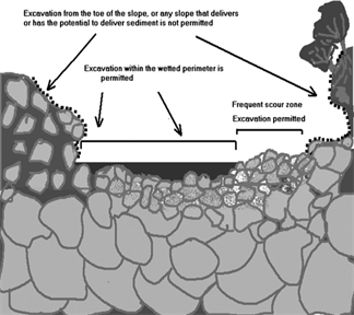 |
Figure 2: Cross section of a typical body of water showing unstable slopes, stable areas, and permitted or prohibited excavation sites when operating a dryland dredge. Dashed lines indicate areas where excavation is not permitted.
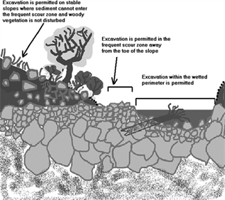 |
Figure 3: Permitted and prohibited excavation sites in a typical body of water under rules for dryland dredging. Dashed lines indicate areas where excavation is not permitted.
(ii) A person must process aggregate collected from upland areas landward of the frequent scour zone only at an upland location landward of the frequent scour zone. A person may not allow tailings or wastewater to enter the wetted perimeter or frequent scour zone.
(f) A person may not use vehicle-mounted winches. A person may use one motorized winch and one hand-operated winch to move boulders and large woody material that is not embedded, and additional cables, chains, or ropes to stabilize them.
(g) When operating a suction dredge or power sluice/suction dredge combination configured and operated as a suction dredge, a person's equipment must be at least two hundred feet from all others also operating this type of equipment or any sluice or rocker box with a riffle area larger than three square feet (including ganged equipment), high-banker, or power sluice. This separation is measured as a radius from the center of the equipment the person is operating. A person may locate this equipment closer than two hundred feet if only one piece of equipment is actually operating within that two hundred foot radius.
(h) As provided in RCW 77.57.010 and 77.57.070, any device a person uses for pumping water from fish-bearing waters must be equipped with a fish guard to prevent fish from entering the pump intake. A person must screen the pump intake with material that has openings no larger than five sixty-fourths inch for square openings, measured side to side, or three thirty-seconds inch diameter for round openings, and the screen must have at least one square inch of functional screen area for every gallon per minute (gpm) of water drawn through it. For example, a one hundred gpm-rated pump would require a screen with a surface area of at least one hundred square inches.
(i) All equipment fueling and servicing must be done so that petroleum products do not enter the wetted perimeter or frequent scour zone. If a petroleum sheen or spill is observed, a person must immediately stop work, remove the equipment from the body of water, and contact the Washington military department emergency management division. A person may not return the equipment to the water until the problem is corrected. A person must store fuel and lubricants outside the frequent scour zone, and in the shade when possible.
(j) A person may work within the wetted perimeter or frequent scour zone only from one-half hour before official sunrise to one-half hour after official sunset. If a person's mineral prospecting equipment exceeds one-half the width of the wetted perimeter of the stream, a person must remove the equipment from the wetted perimeter or move it so that at least fifty percent of the wetted perimeter is free of equipment from one-half hour after official sunset to one-half hour before official sunrise.
(k) A person may not excavate, collect, remove, or process aggregate within four hundred feet of any fishway, dam, or hatchery water intake.
(l) A person must not disturb existing fish habitat improvement structures or stream channel improvements.
(m) A person may not undermine, move, or disturb large woody material embedded in the slopes or located wholly or partially within the wetted perimeter. A person may move large woody material and boulders located entirely within the frequent scour zone, but a person must keep them within the frequent scour zone. A person may not cut large woody material.
(n) A person may not undermine, cut, or disturb live, rooted woody vegetation of any kind.
(o) A person must fill all excavation sites and level all tailing piles before moving to another excavation site or abandoning an excavation site.
(p) A person may not excavate, collect, or remove aggregate from the toe of the slope.
(q) A person may partially divert a body of water into mineral prospecting equipment. However, at no time may the diversion structure be greater than fifty percent of the width of the wetted perimeter, including the width of the equipment. A person may not divert the body of water outside of the wetted perimeter.
(r) A person may use pressurized water only for redistributing dredge tailings within the wetted perimeter, for crevicing using a dryland dredge, or for introducing water under low pressure to an excavation site from the nozzle of a dryland dredge. No other use of pressurized water is permitted.
(s) A person must avoid areas containing live freshwater mussels. If a person encounters live mussels during excavation, a person must relocate the operation.
(t) A person may not disturb redds. If a person observes or encounters redds or actively spawning fish when collecting or processing aggregate, a person must relocate the operation.
(u) If at any time, as a result of project activities, a person observes a fish kill or fish life in distress, a person must immediately stop operations and notify the department and the Washington military department emergency management division of the problem. A person may not resume work until the department gives approval. The department will require additional measures to mitigate the prospecting impacts.
(6) Suction dredging on ocean beaches: A person may suction dredge year-round on ocean beaches of the state. A person must follow the rules listed below:
(a) A person may suction dredge only between the line of ordinary high tide and the line of extreme low tide on beaches within the seashore conservation area set under RCW 79A.05.605 and managed by Washington state parks and recreation commission.
(b) When suction dredging, a person may use only hand-held mineral prospecting tools and the following mineral prospecting equipment:
(i) Motorized or nonmotorized suction dredges that have suction intake nozzles with inside diameters that should be five inches or less, but must be no greater than five and one-quarter inches to account for manufacturing tolerances and possible deformation of the nozzle. The inside diameter of the dredge hose attached to the nozzle may be no greater than one inch larger than the nozzle size;
(ii) Power sluice/suction dredge combinations, when configured and operated as suction dredges, that have suction intake nozzles with inside diameters that should be five inches or less, but must be no greater than five and one-quarter inches to account for manufacturing tolerances and possible deformation of the nozzle. The inside diameter of the dredge hose attached to the suction intake nozzle may be no greater than one inch larger than the nozzle size.
(c) A person may not use vehicle-mounted winches. A person may use one motorized winch and one hand-operated winch to move boulders and large woody material that is not embedded, and additional cables, chains, or ropes to stabilize them.
(d) Under RCW 77.57.010 and 77.57.070, any device a person uses for pumping water from fish-bearing waters must be equipped with a fish guard to prevent fish from entering the pump intake. A person must screen the pump intake with material that has openings no larger than five sixty-fourths inch for square openings, measured side to side, or three thirty-seconds inch diameter for round openings, and the screen must have at least one square inch of functional screen area for every gallon per minute (gpm) of water drawn through it. For example, a one hundred gpm-rated pump would require a screen with a surface area of at least one hundred square inches.
(e) All equipment fueling and servicing must be done so that petroleum products do not enter the wetted perimeter. If a petroleum sheen or spill is observed, a person must immediately stop work, remove the equipment from the body of water and beach, and contact the Washington military department emergency management division. A person may not return the equipment to the water or beach until the problem is corrected. A person must store fuel and lubricants away from the water inside a vehicle or landward of the beach, and in the shade when possible.
(f) A person may work only from one-half hour before official sunrise to one-half hour after official sunset. If a person uses mineral prospecting equipment in a fish-bearing freshwater stream and the equipment exceeds one-half the width of the wetted perimeter of the stream, a person must remove the equipment from the wetted perimeter or move it so that at least fifty percent of the wetted perimeter is free of equipment from one-half hour after official sunset to one-half hour before official sunrise.
(g) A person may not undermine, cut, disturb, or move embedded large woody material or woody debris jams.
(h) A person must backfill all trenches, depressions, or holes created in the beach during project activities before moving to another excavation site (except during use as a settling pond) or leaving an excavation site.
(i) A person may partially divert a body of water into suction dredges. However, at no time may the diversion structure be greater than fifty percent of the width of the wetted perimeter of a fish-bearing stream, including the width of the equipment. A person may not divert the body of water outside of the wetted perimeter.
(j) A person may use materials only from within the wetted perimeter, or artificial materials from outside the wetted perimeter, to construct the diversion structure by hand. Before abandoning the site, a person must remove artificial materials used to construct a diversion structure and restore the site to its approximate original condition.
(k) A person may use pressurized water only for redistributing dredge tailings within the wetted perimeter, for crevicing using a dryland dredge, or for introducing water under low pressure to an excavation site from the nozzle of a dryland dredge. No other use of pressurized water is permitted.
(l) A person may not disturb live razor clams or other shellfish within the bed. If a person observes or encounters live razor clams or other shellfish during excavation, the person must relocate the operation.
(m) If at any time, as a result of project activities, a person observes a fish kill or fish life in distress, a person must immediately stop operations and notify the department, and the Washington military department emergency management division of the problem. A person may not resume work until the department gives approval. The department will require additional measures to mitigate the prospecting impacts.
(7) Authorized work times and suction dredge restrictions by specific state waters for suction dredging projects:
(a) A person may suction dredge under subsection (5) of this section in any of the state waters, with the equipment restrictions, and during the times specified in the following table of authorized work times following issuance of a standard single site or multisite written HPA.
(b) The general work time for a county applies to all state waters within that county unless otherwise indicated in the table.
(c) The work time for state waters identified in the table of authorized work times applies to all its tributaries, unless otherwise indicated. Some state waters occur in multiple counties. Check the table for the county in which mineral prospecting or placer mining is to be conducted to determine the work time for that water body.
(d) Where a tributary is identified as a boundary, that boundary is the line perpendicular to the receiving stream that is projected from the most upstream point of the tributary mouth to the opposite bank of the receiving stream. See Figure 4.
(e) A person wishing to suction dredge within water bodies identified in the table of authorized work times as "submit application" or at different work times or using different equipment than listed in the following table of authorized work times must obtain a standard single site or multisite written HPA to work in these water bodies.
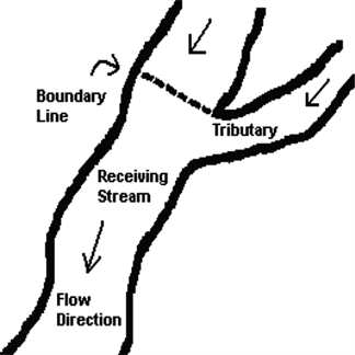 |
Figure 4: Where the boundary is located if a tributary listed as a boundary.
(f) Suction dredging using suction dredges that have suction intake nozzles with inside diameters that should be four inches or less, but must be no greater than four and one-quarter inches to account for manufacturing tolerances and possible deformation of the nozzle, is authorized only in the state waters identified in the table of authorized work times, and any tributaries to them, unless otherwise indicated in the table. The inside diameter of the dredge hose attached to the nozzle may be no greater than one inch larger than the nozzle size.
(g) Suction dredging using suction dredges that have suction intake nozzles with inside diameters that should be five inches or less, but must be no greater than five and one-quarter inches to account for manufacturing tolerances and possible deformation of the nozzle is authorized only in the state waters specifically identified in the table of authorized work times. The inside diameter of the dredge hose attached to the nozzle may be no greater than one inch larger than the nozzle size. A person may use only suction dredges with suction intake nozzle inside diameters of four and one-quarter inches or less in tributaries of these state waters. The inside diameter of the dredge hose attached to the nozzle may be no greater than one inch larger than the nozzle size.
Table 1
Authorized Work Times and Suction Dredge Restrictions by Specific State Waters for Mineral Suction Dredge Projects
Washington Counties and State Waters (Water Resource Inventory Area (WRIA) in parentheses) | Suction Dredging is Allowed Only Between These Dates | State Waters (and tributaries, unless otherwise indicated) in Which a Person May Use Suction Dredges With a Four and One-Quarter Inch Maximum Suction Intake Nozzle Inside Diameter | State Waters (NOTincluding tributaries) in Which a Person May Use Suction Dredges With a Five and One-Quarter Inch Maximum Suction Intake Nozzle Inside Diameter |
Adams County | July 1 - October 31 | X | – |
Crab Creek (41.0002) | July 16 - February 28 | X | X |
Esquatzel Creek (36.MISC) | June 1 - February 28 | X | X |
Palouse River (34.0003) | July 16 - February 28 | X | X |
Asotin County | July 16 - September 15 | X | – |
Snake River (35.0002) | See Below | – | – |
Alpowa Creek (35.1440) | July 16 - December 15 | X | – |
Asotin Creek (35.1716) | July 16 - August 15 | X | – |
Couse Creek (35.2147) | July 16 - December 15 | X | – |
Grande Ronde River (35.2192) | July 16 - September 15 | X | X |
Ten Mile Creek (35.2100) | July 16 - December 15 | X | – |
Benton County | June 1 - September 30 | X | – |
Columbia River | See Below | – | – |
Glade Creek (31.0851) | August 1 - September 30 | X | – |
Yakima River (37.0002) | June 1 - September 15 | X | X |
Amon Wasteway (37.0009) | June 1 - September 30 | X | – |
Corral Creek (37.0002) | June 1 - September 30 | X | – |
Spring Creek (37.0205) | June 1 - September 30 | X | – |
Chelan County | July 16 - August 15 | X | – |
Columbia River | See Below | – | – |
Antoine Creek (49.0294) - Mouth to falls at river mile 1.0 | July 1 - February 28 | X | – |
Antoine Creek (49.0294) - Upstream of falls at river mile 1.0 | July 1 - March 31 | X | – |
Chelan River (47.0052) - Mouth to Chelan Dam | July 16 - September 30 | X | X |
Colockum Creek (40.0760) | July 1 - October 31 | X | – |
Entiat River (46.0042) - Mouth to Entiat Falls | July 16 - July 31 | X | X |
Entiat River (46.0042) - Upstream of Entiat Falls | July 16 - March 31 | X | – |
Crum Canyon (46.0107) | July 16 - March 31 | X | – |
Mad River (46.0125) | July 16 - July 31 | X | – |
Indian Creek (46.0128) | July 16 - February 28 | X | – |
Lake Chelan (47.0052) | Submit Application | – | – |
Railroad Creek (47.0410) | July 16 - September 30 | X | – |
Stehekin River (47.0508) | Submit Application | – | – |
Twenty-Five Mile Creek (47.0195) | July 16 - September 30 | X | – |
Other Lake Chelan tributaries outside of North Cascades National Park | July 1 - August 15 | X | – |
Other Lake Chelan tributaries within North Cascades National Park | Submit Application | – | – |
Number 1 Canyon (45.0011) | July 1 - February 28 | X | – |
Number 2 Canyon (45.0012) | July 1 - February 28 | X | – |
Squilchuck Creek (40.0836) - Mouth to South Wenatchee Avenue | July 1 - September 30 | X | – |
Squilchuck Creek (40.0836) - Upstream of South Wenatchee Avenue | July 1 - February 28 | X | – |
Stemilt Creek (40.0808) - Mouth to falls | July 1 - September 30 | X | – |
Stemilt Creek (40.0808) - Upstream of falls | July 1 - February 28 | X | – |
Wenatchee River (45.0030) - Mouth to Hwy 2 Bridge in Leavenworth | July 15 - September 30 | X | X |
Wenatchee River (45.0030) - Hwy 2 Bridge in Leavenworth to Lake Wenatchee | July 15 - August 15 | X | X |
Beaver Creek (45.0751) | July 1 - September 30 | X | – |
Chiwaukum Creek (45.0700) | July 1 - July 31 | X | – |
Chiwawa River (45.0759) - Mouth to Phelps Creek | July 1 - July 31 | X | X |
Chiwawa River (45.0759) - Upstream of Phelps Creek | July 1 - July 31 | X | – |
Deep Creek (45.0764) | July 1 - February 28 | X | – |
Phelps Creek (45.0875) | July 16 - August 15 | X | – |
Icicle Creek (45.0474) - Mouth to Johnny Creek | July 1 - July 31 | X | X |
Icicle Creek (45.0474) - Upstream of Johnny Creek | July 1 - July 31 | X | – |
Fourth of July Creek (45.0525) | July 1 - February 28 | X | – |
Lake Wenatchee (45.0030) | Submit Application | – | – |
Little Wenatchee (45.0985) - Mouth to Wilderness Boundary | July 1 - July 31 | X | X |
Little Wenatchee (45.0985) - Upstream of Wilderness Boundary | Submit Application | – | – |
White River (45.1116) - Mouth to White River Falls | July 1 - July 31 | X | X |
White River (45.1116) - Upstream of White River Falls | July 1 - February 28 | X | – |
Nason Creek (45.0888) | July 1 - July 31 | X | – |
Peshastin Creek (45.0232) - Mouth to Etienne Creek | July 16 - August 15 | X | – |
Peshastin Creek (45.0232) - Upstream of Etienne Creek | August 1 - February 28 | X | – |
Ingalls Creek (45.0273) - Mouth to Cascade Creek | Submit Application | – | – |
Ingalls Creek (45.0273) - Upstream of Cascade Creek | July 16 - February 28 | X | – |
Etienne Creek (45.0323) - Mouth to falls at stream mile 2.9 | Submit Application | – | – |
Etienne Creek (45.0323) - Upstream of falls at stream mile 2.9 | July 16 - February 28 | X | – |
Ruby Creek (45.0318) | July 16 - February 28 | X | – |
Tronson Creek (45.0346) | August 1 - February 28 | X | – |
Scotty Creek (45.0376) | August 1 - February 28 | X | – |
Shaser Creek (45.0365) | August 1 - February 28 | X | – |
Clallam County | July 16 - September 15 | X | – |
Clallam River (19.0129) | August 1 - August 15 | X | – |
Dungeness River (18.0018) | Submit Application | – | – |
Independent Creek (18.MISC) | August 1 - August 31 | X | – |
Elwha River (18.0272) | August 1 - August 15 | X | X |
Hoko River (19.0148) | August 1 - September 15 | X | – |
Jimmycomelately Creek (17.0285) | August 1 - August 31 | X | – |
Lake Ozette (20.0046) | Submit Application | – | – |
Little Quilcene River (17.0076) | July 16 - August 31 | X | – |
Lake Ozette tributaries | July 16 - September 15 | X | – |
Lyre River (19.0031) | August 1 - September 15 | X | – |
McDonald Creek (18.0160) | August 1 - September 15 | X | – |
Morse Creek (18.0185) | August 1 - August 15 | X | – |
Ozette River (20.0046) | July 16 - September 15 | X | – |
Pysht River (19.0113) | August 1 - September 15 | X | – |
Quillayute River (20.0096, 20.0162, 20.0175) | August 1 - August 15 | X | X |
Bogachiel River (20.0162) | Submit Application | – | – |
Calawah River (20.0175) | August 1 - August 15 | X | X |
Salmon Creek (17.0245) | July 16 - August 31 | X | – |
Sekiu River (19.0203) | August 1 - September 15 | X | – |
Snow Creek (17.0219) | July 16 - August 31 | X | – |
Sol Duc River (20.0096) | Submit Application | – | – |
Lake Pleasant (20.0313) | Submit Application | – | – |
Lake Pleasant tributaries | July 16 - September 15 | X | – |
Sooes River (20.0015) | July 16 - September 15 | X | – |
Clark County | July 16 - September 30 | – | – |
Columbia River | See Below | – | – |
Lacamas Creek (28.0160) - Mouth to dam | August 1 - August 31 | X | – |
Lacamas Creek (28.0160) - Upstream of dam | August 1 - September 30 | X | – |
Lewis River (27.0168) | August 1 - August 15 | X | X |
East Fork Lewis River (27.0173) - Mouth to Lucia Falls | August 1 - August 15 | X | X |
East Fork Lewis River (27.0173) - Lucia Falls to Sunset Falls | August 1 - February 28 | X | X |
East Fork Lewis River (27.0173) - Upstream of Sunset Falls | August 1 - February 28 | X | – |
Lake River (28.0020) | January 1 - December 31 | X | X |
Burnt Bridge Creek (28.0143) | August 1 - August 31 | X | – |
Salmon Creek (28.0059) | August 1 - August 31 | X | – |
Whipple Creek (28.0038) | August 1 - September 30 | X | – |
North Fork Lewis River (27.0334) - Confluence of East Fork to Merwin Dam | August 1 - August 15 | X | X |
Cedar Creek (27.0339) | August 1 - September 15 | X | – |
North Fork Lewis River (27.0334) - Merwin Dam to Lower Falls | July 16 - August 15 | X | X |
Canyon Creek (27.0442) | July 16 - February 28 | X | – |
North Fork Lewis River (27.0168) - Upstream of Lower Falls | July 16 - August 15 | X | X |
Washougal River (28.0159) - Mouth to headwaters | August 1 - August 31 | X | X |
Columbia County | July 16 - September 30 | X | – |
Touchet River (32.0097) | August 1 - August 15 | X | X |
Grande Ronde River tributaries (35.2192) | July 16 - August 15 | X | – |
North Fork Touchet/Wolf Fork (32.0761) | Submit Application | – | – |
South Fork Touchet (32.0708) | Submit Application | – | – |
Tucannon River (35.0009) | July 16 - August 15 | X | X |
Walla Walla River (32.0008) - Mouth to Oregon state line | July 16 - September 15 | X | X |
Mill Creek (32.1436) - Mouth to Oregon state line | August 1 - August 15 | X | – |
Cowlitz County | July 16 - September 30 | X | – |
Chehalis River (22.0190/23.0190) - South Fork Chehalis River - Mouth to Fisk Falls | August 1 - August 31 | X | X |
Chehalis River (22.0190/23.0190) - South Fork Chehalis River - Upstream of Fisk Falls | August 1 - August 31 | X | – |
Columbia River | See Below | – | – |
Abernathy Creek (25.0297) | July 16 - September 15 | X | – |
Burke Creek (27.0148) | August 1 - August 31 | X | – |
Burris Creek (27.0151) | August 1 - August 31 | X | – |
Bybee Creek (27.0142) | August 1 - August 31 | X | – |
Canyon Creek (27.0147) | August 1 - August 31 | X | – |
Coal Creek (25.0340) | July 16 - September 15 | X | – |
Clark Creek (25.0371) | August 1 - August 31 | X | – |
Cowlitz River (26.0002) - Mouth to barrier dam at river mile 49.5 | July 16 - August 15 | X | X |
Coweeman River (26.0003) - Mouth to Baird Creek | August 1 - August 31 | X | X |
Coweeman River (26.0003) - Upstream of Baird Creek | August 1 - August 31 | X | – |
Cowlitz River (26.0002) - Tributaries below barrier dam to mouth | July 16 - September 30 | X | – |
Owl Creek (26.1441) | July 16 - September 15 | X | – |
Toutle River (26.0227) | July 16 - August 15 | X | X |
North Fork Toutle River (26.0314) - Mouth to Debris Dam | July 16 - August 15 | X | X |
North Fork Toutle River (26.0314) - Upstream of Debris Dam | July 16 - August 15 | X | – |
Green River (26.0323) - Mouth to Shultz Creek | July 16 - September 30 | X | X |
Green River (26.0323) - Upstream of Shultz Creek | July 16 - September 30 | X | – |
South Fork Toutle (26.0248) - Mouth to Bear Creek | July 16 - September 15 | X | X |
South Fork Toutle (26.0248) - Upstream of Bear Creek | July 16 - September 15 | X | – |
Tributaries to Silver Lake | July 16 - September 30 | X | – |
Germany Creek (25.0313) | July 16 - September 15 | X | – |
Kalama River (27.0002) - Mouth to Kalama Falls | August 1 - August 15 | X | X |
Kalama River (27.0002) - Upstream of Kalama Falls | August 1 - August 15 | X | – |
Lewis River (27.0168) - Mouth to East Fork Lewis River | August 1 - August 15 | X | X |
North Fork Lewis River (27.0334) - Confluence of East Fork to Merwin Dam | August 1 - August 15 | X | X |
North Fork Lewis River (27.0334) - Merwin Dam to Lower Falls | July 16 - August 15 | X | X |
Mill Creek (25.0284) | July 16 - September 15 | X | – |
Schoolhouse Creek (27.0139) | August 1 - August 31 | X | – |
Douglas County | July 1 - September 30 | X | – |
Columbia River | See Below | – | – |
Douglas Creek Canyon (44.0146) | May 16 - January 31 | X | – |
Foster Creek (50.0065) | August 1 - April 15 | X | – |
McCarteney Creek (44.0002) | July 1 - February 28 | X | – |
Pine/Corbaley Canyon Creek (44.0779) | September 16 - April 15 | X | – |
Rock Island Creek (44.0630) | July 1 - September 30 | X | – |
Ferry County | July 1 - August 31 | X | – |
Columbia River | See Below | – | – |
Kettle River (60.0002) | June 16 - August 31 | X | X |
Boulder Creek (60.0130) - Mouth to Hodgson Road Bridge | Submit Application | – | – |
Boulder Creek (60.0130) - Upstream of Hodgson Road Bridge | June 16 - February 28 | X | – |
Deadman Creek (60.0008) - Mouth to SR395 Crossing | Submit Application | – | – |
Deadman Creek (60.0008) - Upstream of SR395 | June 16 - February 28 | X | – |
Goosmus Creek (60.0254) | June 16 - February 28 | X | – |
Toroda Creek (60.0410) | July 1 - September 30 | X | – |
San Poil River (52.0004) | June 16 - September 30 | X | X |
Granite Creek (52.0099) - Mouth to Powerhouse Dam | June 16 - September 30 | X | – |
Granite Creek (52.0099) - Upstream of Powerhouse Dam | June 16 - February 28 | X | – |
West Fork San Poil River (52.0192) - Mouth to Deep Creek | June 16 - September 30 | X | X |
West Fork San Poil River (52.0192) - Upstream of Deep Creek | June 16 - September 30 | X | – |
Gold Creek (52.0197) | June 16 - February 28 | X | – |
Franklin County | June 1 - September 30 | X | – |
Columbia River | See Below | – | – |
Snake River | See Below | – | – |
Palouse River (34.0003) | July 16 - February 28 | X | X |
North bank tributaries of the lower Snake River between Palouse River and the mouth of the Snake River | June 16 - October 31 | X | – |
Garfield County | July 16 - September 30 | X | – |
Snake River (35.0003) | See Below | – | – |
Alpowa Creek (35.1440) | July 16 - December 15 | X | – |
Asotin Creek (35.1716) | July 16 - August 15 | X | – |
Deadman Creek (35.0688) | July 16 - December 15 | X | – |
Grande Ronde River tributaries (35.2192) | July 16 - August 15 | X | – |
Meadow Creek (35.0689) | July 16 - December 15 | X | – |
Tucannon River (35.0009) - Mouth to Panjab Creek | July 16 - August 15 | X | X |
Tucannon River (35.0009) - Upstream of Panjab Creek | July 16 - August 15 | X | – |
Pataha Creek (35.0123) - Mouth to Pataha Creek | January 1 - December 31 | X | – |
Pataha Creek (35.0123) - Upstream of Pataha Creek | July 16 - December 31 | X | – |
Grant County | July 1 - October 31 | X | – |
Columbia River | See Below | – | – |
Crab Creek (41.0002) | July 16 - September 15 | X | X |
Grays Harbor County | July 16 - October 15 | X | – |
Chehalis River (22.0190/23.0190) - Mouth to Porter Creek | August 1 - August 31 | X | X |
Chehalis River (22.0190/23.0190) - Porter Creek to Fisk Falls | August 1 - August 15 | X | X |
Chehalis River (22.0190/23.0190) - Upstream of Fisk Falls | August 1 - August 15 | X | – |
Cedar Creek (23.0570) | August 1 - September 30 | X | – |
Cloquallum Creek (22.0501) | August 1 - September 30 | X | – |
Porter Creek (23.0543) | August 1 - September 30 | X | – |
Satsop River (22.0360) | August 1 - August 31 | X | X |
Wishkah River (22.0191) | August 1 - October 15 | X | X |
Wynoochee River (22.0260) | August 1 - September 30 | X | X |
Copalis River (21.0767) | August 1 - October 15 | X | X |
Elk River (22.1333) | July 1 - October 31 | X | X |
Hoquiam River (22.0137) | August 1 - October 15 | X | X |
Humptulips River (22.0004) - Mouth to Forks | August 1 - September 30 | X | X |
Humptulips River (22.0004) - Upstream of Forks | August 1 - September 30 | X | – |
Johns River (22.1270) | August 1 - September 30 | X | X |
Moclips River (21.0731) | August 1 - October 15 | X | X |
North River (24.0034) | August 1 - September 30 | X | X |
Queets River (21.0001) | August 1 - August 15 | X | X |
Quinault River (21.0398) | August 1 - August 15 | X | X |
Raft River (21.0337) | August 1 - October 15 | X | X |
Island County | June 16 - October 15 | X | – |
Cavalero Creek (06.0065) | June 16 - December 15 | X | – |
Chapman Creek (06.0070) | June 16 - December 15 | X | – |
Crescent Creek (06.0002) | June 16 - December 15 | X | – |
Cultus Creek (06.0026) | June 16 - March 15 | X | – |
Deer Creek (06.0024) | June 16 - March 15 | X | – |
Dugualla Creek (06.0001) | June 16 - March 15 | X | – |
Glendale Creek (06.0025) | June 16 - December 15 | X | – |
Kristoferson Creek (06.0062-06.0063) | May 1 - December 15 | X | – |
Maxwelton Creek (06.0029) | June 16 - December 15 | X | – |
North Bluff Creek (06.0006) | June 16 - March 15 | X | – |
Old Clinton Creek (06.0023) | June 16 - March 15 | X | – |
Jefferson County | July 16 - October 31 | X | – |
Big Quilcene River (17.0012) - Mouth to falls | July 16 - August 31 | X | X |
Big Quilcene River (17.0012) - Falls to Forks | August 1 - February 28 | X | X |
Big Quilcene River (17.0012) - Upstream of Forks | August 1 - February 28 | X | – |
Bogachiel River (20.0162) | Submit Application | – | – |
Chimacum Creek (17.0203) | July 16 - September 15 | X | – |
Donovan Creek (17.0115) | July 1 - October 15 | X | – |
Dosewallips River (16.0442) | July 16 - August 15 | X | – |
Duckabush River (16.0351) | July 16 - August 15 | X | – |
Dungeness River (18.0018) | August 1 - August 15 | X | – |
Elwha River (18.0272) | August 1 - August 15 | X | X |
Goodman Creek (20.0406) | August 1 - September 15 | X | – |
Hoh River (20.0422) | August 1 - August 15 | X | X |
Little Quilcene River (17.0076) | July 16 - August 31 | X | – |
Queets River (21.0001) | August 1 - August 15 | X | X |
Matheny Creek (21.0165) | August 1 - August 15 | X | – |
Sams River (21.0205) | August 1 - August 15 | X | X |
Quinault River (21.0398) | August 1 - August 15 | X | X |
Salmon Creek (17.0245) | July 16 - August 31 | X | – |
Skokomish River (16.0001) | August 1 - August 31 | X | X |
Snow Creek (17.0219) | July 16 - August 31 | X | – |
Tarboo Creek (17.0129) | August 1 - September 30 | X | – |
Thorndyke Creek (17.0170) | August 1 - October 15 | X | – |
King County | July 16 - September 30 | X | – |
Cedar River (08.0299) - Mouth to Forks | August 1 - August 31 | X | X |
Cedar River (08.0299) - Upstream of Forks | August 1 - August 31 | X | – |
Issaquah Creek (08.0178) | August 1 - August 31 | X | – |
Sammamish River (08.0057) | August 1 - August 31 | X | – |
Steele Creek (08.0379) | July 16 - February 28 | X | – |
Green River (Duwamish River) (09.0001) - Mouth to Sawmill Creek | August 1 - August 31 | X | X |
Green River (Duwamish River) (09.0001) - Upstream of Sawmill Creek | August 1 - August 31 | X | – |
Lake Washington tributaries (08.LKWA) | August 1 - August 31 | X | – |
Snoqualmie River (07.0219) - Mouth to Snoqualmie Falls | August 1 - August 15 | X | X |
Snoqualmie River (07.0219) - Snoqualmie Falls to mouth of South Fork | July 16 - February 28 | X | X |
Patterson Creek (07.0376) | July 16 - September 30 | X | – |
Middle Fork Snoqualmie River (07.0219) - Mouth to Taylor Creek | July 16 - February 28 | X | X |
Middle Fork Snoqualmie River (07.0219) - Upstream of Taylor Creek | July 16 - February 28 | X | – |
Goat Creek (07.0754) | July 16 - February 28 | X | – |
North Fork Snoqualmie River (07.0527) - Mouth to Lennox Creek | July 16 - February 28 | X | X |
North Fork Snoqualmie River (07.0527) - Upstream of Lennox Creek | July 16 - February 28 | X | – |
Deep Creek (07.0562) | July 16 - February 28 | X | – |
Illinois Creek (07.0624) | July 16 - February 28 | X | – |
Lennox Creek (07.0596) | July 16 - February 28 | X | – |
Bear Creek (07.0606) | July 16 - February 28 | X | – |
Raging River (07.0384) | August 1 - September 15 | X | X |
South Fork Skykomish River (07.0012) - Mouth to Sunset Falls | August 1 - August 15 | X | X |
South Fork Skykomish River (07.0012) - Upstream of Sunset Falls | August 1 - August 15 | X | – |
Beckler River (07.1413) - Mouth to Boulder Creek | August 1 - August 15 | X | X |
Beckler River (07.1413) - Upstream of Boulder Creek | July 16 - February 28 | X | – |
Rapid River (07.1461) - Mouth to Meadow Creek | August 1 - August 31 | X | X |
Rapid River (07.1461) - Upstream of Meadow Creek | August 1 - February 28 | X | – |
Index Creek (07.1264) - Mouth to Mud Lake Creek | August 1 - August 31 | X | – |
Index Creek (07.1264) - Upstream of Mud Lake Creek including Salmon Creek | July 16 - February 28 | X | – |
Miller River (07.1329) - Mouth to Forks | August 1 - August 15 | X | X |
Miller River (07.1329) - Upstream of Forks | August 1 - August 15 | X | – |
Coney Creek (07.1347) | July 16 - February 28 | X | – |
East Fork Miller River (07.1329) - Mouth to Great Falls Creek | July 16 - August 15 | X | – |
East Fork Miller River (07.1329) - Upstream of Great Falls Creek | July 16 - February 28 | X | – |
Foss River (07.1562) - Mouth to Forks | July 16 - August 31 | X | X |
East Fork Foss River (07.1562) - Mouth to Burn Creek | July 16 - August 15 | X | X |
East Fork Foss River (07.1562) - Upstream of Burn Creek | July 16 - February 28 | X | – |
West Fork Foss River (07.1573) - Mouth to falls at river mile 2.0 | July 16 - August 31 | X | – |
West Fork Foss River (07.1573) - Upstream of falls at river mile 2.0 | July 16 - February 28 | X | – |
West Fork Miller River (07.1335) | July 16 - February 28 | X | X |
Money Creek (07.1300) - Mouth to 0.5 mile upstream of Kimball Creek | August 1 - August 31 | X | – |
Money Creek (07.1300) - Upstream of 0.5 mile upstream of Kimball Creek | August 1 - February 28 | X | – |
Kimball Creek (07.1301) | August 1 - August 31 | X | – |
Tye River (07.0012) - Mouth to Alpine Falls | August 1 - August 31 | X | X |
Tye River (07.0012) - Upstream of Alpine Falls | July 16 - February 28 | X | – |
South Fork Snoqualmie River (07.0467) | July 16 - February 28 | X | X |
Denny Creek (07.0517) | July 16 - February 28 | X | – |
Tolt River (07.0291) - Mouth to Forks | August 1 - August 31 | X | X |
North Fork Tolt River (07.0291) - Mouth to Yellow Creek | July 16 - September 15 | X | X |
North Fork Tolt River (07.0291) - Upstream of Yellow Creek | July 16 - February 28 | X | – |
South Fork Tolt River (07.0302) - Mouth to dam | July 16 - September 15 | X | X |
South Fork Tolt River (07.0302) - Upstream of Tolt Reservoir | July 16 - February 28 | X | – |
Yellow Creek (07.0337) | July 16 - February 28 | X | – |
White River (10.0031) | July 16 - August 15 | X | X |
Greenwater River (10.0122) | July 16 - August 15 | X | X |
Kittitas County | July 1 - September 30 | X | – |
Brushy Creek (40.0612) | July 1 - February 28 | X | – |
Colockum Creek (40.0760) | July 1 - October 31 | X | – |
Quilomene Creek (40.0613) | July 1 - October 31 | X | – |
Stemilt Creek (40.0808) - Upstream of falls | July 1 - February 28 | X | – |
Tarpiscan Creek (40.0723) | July 1 - February 28 | X | – |
Tekiason Creek (40.0686) | July 1 - February 28 | X | – |
Whiskey Dick Creek (40.0591) | July 1 - February 28 | X | – |
Yakima River (39.0002) - Roza Dam to Teanaway River | August 1 - August 31 | X | X |
Naches River (38.0003) - Tieton River to Bumping River | July 1 - August 15 | X | X |
Little Naches River (38.0852) - Mouth to Matthew Creek | July 16 - August 15 | X | X |
Little Naches River (38.0852) - Upstream of Matthew Creek | July 16 - August 15 | X | – |
Pileup Creek (38.0932) | July 16 - August 31 | X | – |
Gold Creek (38.MISC) | July 16 - February 28 | X | – |
Swauk Creek (39.1157) | July 16 - September 30 | X | – |
Baker Creek (39.1157) | July 16 - September 30 | X | – |
First Creek (39.1157) | July 16 - September 30 | X | – |
Iron Creek (39.1157) | July 16 - September 30 | X | – |
Williams Creek (39.1157) | July 16 - September 30 | X | – |
Boulder Creek (39.1157) | July 16 - February 28 | X | – |
Cougar Gulch (39.1157) | July 16 - February 28 | X | – |
Lion Gulch (39.1157) | July 16 - February 28 | X | – |
Yakima River (39.0002) - Teanaway River to Easton Dam | August 1 - August 31 | X | X |
Yakima River (39.0002) - Upstream of Easton Dam | August 1 - August 31 | X | X |
Cle Elum River (39.1434) - Mouth to dam | July 16 - August 31 | X | X |
Cle Elum River (39.1434) - Upstream of Cle Elum Dam | Submit Application | – | – |
Big Boulder Creek (39.1434MISC) | August 1 - February 28 | X | – |
Camp Creek (39.1434MISC) | August 1 - February 28 | X | – |
Fortune Creek (39.1434MISC) | August 1 - August 15 | X | – |
South Fork Fortune Creek (39.1434MISC) | August 1 - February 28 | X | – |
Howson Creek (39.1434) | July 16 - February 28 | X | – |
Little Salmon Le Sac Creek (39.1482) | August 1 - August 15 | X | – |
Paris Creek (39.1434MISC) | August 1 - February 28 | X | – |
Salmon Le Sac Creek (39.1520) | August 1 - February 28 | X | – |
Kachess River (39.1739) - Upstream of Lake Kachess | Submit Application | – | – |
Kachess River (39.1739) - Below dam | July 16 - August 15 | X | X |
Box Canyon Creek (39.1765) | Submit Application | – | – |
Mineral Creek (39.1792) | August 1 - August 15 | X | – |
Lake Keechelus (39.1842) tributaries | July 16 - August 15 | X | – |
Gold Creek (Lake Keechelus) (39.1842) | Submit Application | – | – |
Manastash Creek (39.0988) | July 16 - September 30 | X | – |
Naneum Creek (39.0821) | July 16 - September 30 | X | – |
Taneum Creek (39.1081) - Mouth to I-90 | July 16 - August 31 | X | – |
Taneum Creek (39.1157) - Upstream of I-90 | July 16 - September 30 | X | – |
Teanaway River (39.1236) | July 16 - August 31 | X | X |
NF Teanaway River (39.1260) | Submit Application | – | – |
Umtanum Creek (39.0553) | July 16 - September 30 | X | – |
Wenas Creek, Below dam (39.0032) | July 16 - October 15 | X | – |
Wenas Creek, Upstream of Wenas Lake (39.0032) | July 16 - February 28 | X | – |
Other Yakima River tributaries not listed | July 16 - August 31 | X | – |
Kitsap County | July 16 - October 15 | X | – |
Anderson Creek (15.0211) | August 1 - November 15 | X | – |
Barker Creek (15.0255) | August 1 - September 30 | X | – |
Big Beef Creek (15.0389) | August 1 - August 15 | X | – |
Big Scandia Creek (15.0280) | August 1 - September 30 | X | – |
Blackjack Creek (15.0203) | August 1 - September 30 | X | – |
Burley Creek (15.0056) | August 1 - September 30 | X | – |
Chico Creek (15.0229) | August 1 - October 15 | X | – |
Clear Creek (15.0249) | August 1 - September 30 | X | – |
Curley Creek (15.0185) | August 1 - September 30 | X | – |
Dewatto River (15.0420) | August 1 - August 15 | X | – |
Dogfish Creek (15.0285) | August 1 - August 15 | X | – |
Gorst Creek (15.0216) | August 1 - August 15 | X | – |
Grovers Creek (15.0299) | August 1 - August 31 | X | – |
Johnson Creek (15.0387) | August 1 - October 31 | X | – |
Ollala Creek (15.0107) | August 1 - September 30 | X | – |
Ross Creek (15.0209) | August 1 - November 15 | X | – |
Salmonberry Creek (15.0188) | August 1 - November 30 | X | – |
Seabeck Creek (15.0400) | August 1 - August 15 | X | – |
Steele Creek (15.0273) | August 1 - September 30 | X | – |
Tahuya River (15.0446) | August 1 - August 31 | X | X |
Union River (15.0503) | August 1 - August 31 | X | X |
Klickitat County | July 15 - September 30 | X | – |
Alder Creek (31.0459) | August 1 - September 30 | X | – |
Chapman Creek (31.0192) | August 1 - September 30 | X | – |
Glade Creek (31.0851) | August 1 - September 30 | X | – |
Juniper Canyon Creek (31.0378) | August 1 - September 30 | X | – |
Klickitat River (30.0002) - Mouth to Klickitat hatchery | Submit Application | – | – |
Klickitat River (30.0002) - Upstream of Klickitat hatchery | Submit Application | – | – |
Little White Salmon River (29.0131) - Mouth to Cabbage Creek | July 16 - January 31 | X | X |
Little White Salmon River (29.0131) - Upstream of Cabbage Creek | July 16 - January 31 | X | – |
Pine Creek (31.0354) | August 1 - September 30 | X | – |
Rock Creek (31.0014) | August 1 - September 30 | X | – |
Six Prong Creek (31.0465) | August 1 - September 30 | X | – |
White Salmon River (29.0160) - Mouth to Cascade Creek | July 16 - August 15 | X | X |
White Salmon River (29.0160) - Upstream of Cascade Creek | July 16 - August 15 | X | – |
Wood Gulch Creek (31.0263) | August 1 - September 30 | X | – |
Lewis County | August 1 - September 30 | X | – |
Chehalis River (22.0190/23.0190) - Mouth to South Fork Chehalis River | August 1 - August 15 | X | X |
Chehalis River (22.0190/23.0190) - Upstream of South Fork Chehalis River | August 1 - August 31 | X | X |
Newaukum River (23.0882) - Mouth to South Fork | August 1 - August 31 | X | X |
Newaukum River (23.0882) - Upstream of South Fork | August 1 - August 31 | X | – |
Skookumchuck River (23.0761) | August 1 - August 31 | X | X |
Cowlitz River (26.0002) | August 1 - August 15 | X | X |
Cispus River (26.0668) - Mouth to Squaw Creek (26.1010) | August 1 - August 15 | X | X |
Cispus River (26.0668) - Squaw Creek to Chambers Creek | July 16 - February 28 | X | X |
Cispus River (26.0668) - Upstream of Chambers Creek | July 16 - February 28 | X | – |
Yellowjacket Creek (26.0757) | August 1 - August 15 | X | – |
McCoy Creek (26.0766) - Mouth to lower falls | August 1 - August 15 | X | – |
McCoy Creek (26.0766) - Upstream of lower falls | July 16 - February 28 | X | – |
Walupt Creek (26.1010) | Submit Application | – | – |
Packwood Lake tributaries | August 16 - September 15 | X | – |
Tilton River (26.0560) - Mouth to North Fork | August 1 - September 30 | X | X |
Tilton River (26.0560) - Upstream of North Fork | August 1 - September 30 | X | – |
Toutle River (26.0227) | August 1 - August 31 | X | X |
North Fork Toutle River (26.0314) | July 16 - August 15 | X | X |
Green River (26.0323) | July 16 - September 30 | X | X |
Deschutes River (13.0028) | July 16 - August 31 | X | X |
Little Deschutes River (13.0110) | July 16 - February 28 | X | – |
Nisqually River (11.0008) - Upstream of Alder Lake | July 16 - September 30 | X | X |
Lincoln County | June 16 - February 28 | X | – |
Columbia River | See Below | – | – |
Hawk Creek (53.0101) - Mouth to falls | June 16 - August 31 | X | – |
Hawk Creek (53.0101) - Upstream of falls | June 16 - February 28 | X | – |
Upper Crab Creek (42.0001) | June 16 - February 28 | X | – |
Wilson Creek (43.0020) | June 16 - February 28 | X | – |
Mason County | August 1 - October 15 | X | – |
Cloquallum Creek (22.0501) | August 1 - September 30 | X | – |
Coulter Creek (15.0002) | August 1 - August 31 | X | – |
Dewatto River (15.0420) | August 1 - August 31 | X | – |
Goldsborough Creek (14.0035) | August 1 - October 15 | X | – |
John Creek (16.0253) | August 1 - August 31 | X | – |
Hamma Hamma River (16.0251) - Mouth to falls | August 1 - August 31 | X | – |
Johns Creek (14.0049) | August 1 - August 15 | X | – |
Lilliwaup River (16.0230) - Mouth to falls | August 1 - August 31 | X | X |
Lilliwaup River (16.0230) - Upstream of falls | August 1 - February 28 | X | – |
Mill Creek (14.0029) | August 1 - August 15 | X | – |
Satsop River (22.0360) | August 1 - August 31 | X | – |
Schaerer Creek (16.0326) | August 1 - August 31 | X | – |
Sherwood Creek (14.0094) | August 1 - August 15 | X | – |
Skokomish River (16.0001) - Mouth to Forks | August 1 - August 31 | X | X |
Skokomish River (16.0001) - Upstream of Forks | August 1 - August 31 | X | – |
Tahuya River (15.0446) | August 1 - August 31 | X | – |
Twanoh Creek (14.0134) | August 1 - October 31 | X | – |
Union River (15.0503) | August 1 - August 31 | X | X |
Okanogan County | July 1 - August 15 | X | – |
Aneas Creek (49.0243) - Mouth to falls | July 16 - August 31 | X | – |
Aneas Creek (49.0243) - Upstream of falls | July 1 - March 31 | X | – |
Chewiliken Creek (49.0232) - Mouth to falls | July 16 - August 31 | X | – |
Chewiliken Creek (49.0232) - Upstream of falls | July 1 - March 31 | X | – |
Chiliwist Creek (49.0034) - Mouth to falls | July 16 - August 31 | X | – |
Chiliwist Creek (49.0034) - Upstream of falls | July 1 - March 31 | X | – |
Foster Creek (50.0065) | July 1 - February 28 | X | – |
Methow River (48.0007) - Columbia confluence to Twisp River | July 1 - July 31 | X | X |
Methow River tributaries between Black Canyon Creek and Gold Creek | July 1 - February 28 | X | – |
Black Canyon Creek (48.0015) - Mouth to Left Fork | Submit Application | – | – |
Black Canyon Creek (48.0015) - Upstream of Left Fork | July 1 - February 28 | X | – |
Gold Creek (48.0104) - Mouth to Foggy Dew Creek | Submit Application | – | – |
Foggy Dew Creek (48.0153) - Mouth to Foggy Dew Falls | Submit Application | – | – |
Foggy Dew Creek (48.0153) - Upstream of Foggy Dew Falls | July 1 - February 28 | X | – |
Middle Fork Gold Creek (48.0139) | July 1 - February 28 | X | – |
North Fork Gold Creek (48.0104) | Submit Application | – | – |
Crater Creek (48.0177) - Mouth to Martin Creek | Submit Application | – | – |
Crater Creek (48.0177) - Upstream of Martin Creek | July 1 - February 28 | X | – |
Martin Creek (48.0177) | July 1 - February 28 | X | – |
South Fork Gold Creek (48.0105) - Mouth to Rainy Creek | Submit Application | – | – |
South Fork Gold Creek (48.0105) - Upstream of Rainy Creek | July 1 - February 28 | X | – |
Rainy Creek (48.0105) | July 1 - February 28 | X | – |
McFarland Creek (48.0090) - Mouth to Vinegar Gulch | Submit Application | – | – |
McFarland Creek (48.0090) - Upstream of Vinegar Gulch | July 1 - February 28 | X | – |
Methow River tributaries between Libby Creek and Beaver Creek | July 1 - February 28 | X | – |
Beaver Creek (48.0307) | Submit Application | – | – |
Frazer Creek (48.0309) | July 1 - February 28 | X | – |
Lightning Creek (48.0361) | July 1 - February 28 | X | – |
Middle Fork Beaver Creek (48.0307) | July 1 - February 28 | X | – |
South Fork Beaver Creek (48.0342) | July 1 - February 28 | X | – |
Libby Creek (48.0203) - Mouth to Hornet Draw Creek | Submit Application | – | – |
Libby Creek (48.0203) - Upstream of Hornet Draw | July 1 - February 28 | X | – |
Methow River (48.0007) - Twisp River to Goat Creek | July 1 - July 31 | X | X |
Methow River (48.0007) - Upstream of Goat Creek | July 1 - July 31 | X | – |
Chewuch River (48.0728) - Mouth to Meadow Creek | July 1 - July 31 | X | X |
Chewuch River (48.0728) - Upstream of Meadow Creek | July 1 - February 28 | X | – |
Early Winters Creek (48.1408) - Mouth to Silver Star Creek | Submit Application | – | – |
Early Winters Creek (48.1408) - Upstream of Silver Star Creek | July 1 - February 28 | X | – |
Goat Creek (48.1364) - Mouth to 500 feet upstream of Montana Creek | Submit Application | – | – |
Goat Creek (48.1364) - 500 feet Upstream of Montana Creek to Roundup Creek | July 1 - February 28 | X | – |
Goat Creek (48.1364) - Upstream of Roundup Creek | Submit Application | – | – |
Lost River (48.0592) | July 16 - August 15 | X | X |
Twisp River (48.0374) | July 1 - July 31 | X | X |
Buttermilk Creek (48.0466) | Submit Application | – | – |
North Creek (48.0674) | Submit Application | – | – |
North Fork Twisp River (48.0691) | July 1 - February 28 | X | – |
South Creek (48.0641) - Upstream of Louis Creek | July 1 - February 28 | X | – |
South Creek (48.0641) - Mouth to Louis Creek | Submit Application | – | – |
South Fork Twisp River (48.0698) | July 1 - February 28 | X | – |
Wolf Creek (48.1300) | Submit Application | – | – |
Myers Creek (60.0517) | July 1 - February 28 | X | – |
Bolster Creek (60.0517) | July 1 - February 28 | X | – |
Ethel Creek (60.0517) | July 1 - February 28 | X | – |
Gold Creek (60.0517) | July 1 - February 28 | X | – |
Mary Ann Creek (60.0517) | July 1 - February 28 | X | – |
North Fork Mary Ann Creek (60.0517) | July 1 - February 28 | X | – |
Okanogan River (49.0019) - Mouth to Zosel Dam | July 1 - August 31 | X | X |
Antoine Creek (49.0294) - Mouth to velocity gradient at river mile 1.0 | July 1 - February 28 | X | – |
Antoine Creek (49.0294) - Upstream of falls | July 1 - March 31 | X | – |
Bonaparte Creek (49.0246) - Upstream of falls | July 1 - March 31 | X | – |
Bonaparte Creek (49.0246) - Mouth to Bonaparte Falls at river mile 1.0 | July 1 - February 28 | X | – |
Loup Loup Creek (49.0048) - Mouth to Loup Loup Falls at river mile 2.4 | July 1 - February 28 | X | – |
Loup Loup Creek (49.0048) - Upstream of Loup Loup Falls at river mile 2.4 | July 1 - March 31 | X | – |
Mosquito Creek (49.0321) - Mouth to falls | July 1 - August 31 | X | – |
Mosquito Creek (49.0321) - Upstream of falls | July 1 - March 31 | X | – |
Nine Mile Creek (49.0516) | July 1 - February 28 | X | – |
Omak Creek (49.0138) - Mouth to Mission Falls at river mile 5.4 | July 1 - February 28 | X | – |
Omak Creek (49.0138) - Upstream of falls | July 1 - March 31 | X | – |
Salmon Creek (49.0079) - Mouth to diversion | July 1 - August 31 | X | – |
Salmon Creek (49.0079) - Upstream of diversion | July 1 - February 28 | X | – |
Similkameen River (49.0325) - Mouth to Enloe Dam | July 1 - August 31 | X | X |
Similkameen River (49.0325) - Enloe Dam to Palmer Creek | June 1 - October 31 | X | X |
Similkameen River (49.0325) - Upstream of Palmer Creek | July 1 - October 31 | X | X |
Sinlahekin Creek (49.0349) - Mouth to barrier dam at Connors Lake | July 1 - August 31 | X | – |
Cecile Creek (49.0447) | July 1 - February 28 | X | – |
Chopaka Creek (49.0357) | July 1 - February 28 | X | – |
Toats Coulee Creek (49.0368) | July 1 - February 28 | X | – |
Cougar Creek (49.0368) | July 1 - February 28 | X | – |
Siwash Creek (49.0284) - Falls to headwaters | July 1 - March 31 | X | – |
Siwash Creek (49.0284) - Mouth to falls at river mile 1.4 | July 1 - February 28 | X | – |
Tonasket Creek (49.0501) - Mouth to Tonasket Falls at river mile 1.8 | July 1 - February 28 | X | – |
Tonasket Creek (49.0501) - Upstream of Tonasket Falls at river mile 1.8 | July 1 - March 31 | X | – |
Tunk Creek (49.0211) - Mouth to falls | July 1 - February 28 | X | – |
Tunk Creek (49.0211) - Upstream of falls | July 1 - March 31 | X | – |
San Poil River (52.0004) | June 16 - September 30 | X | X |
West Fork San Poil (52.0192) | June 16 - September 30 | X | X |
Gold Creek (52.0197) | June 16 - February 28 | X | – |
Toroda Creek (60.0410) | July 1 - September 30 | X | – |
Pacific County | August 1 - September 30 | X | – |
Bear River (24.0689) | August 1 - September 30 | X | X |
Bone River (24.0405) | August 1 - September 30 | X | – |
Chehalis River (22.0190/23.0190) | August 1 - August 15 | X | X |
Columbia River | See Below | – | – |
Chinook River (24.MISC) | August 1 - September 30 | X | X |
Grays River (25.0093) | July 16 - September 15 | X | X |
Naselle River (24.0543) | August 1 - September 15 | X | X |
Nemah River (24.0460) | August 1 - September 30 | X | X |
Niawiakum River (24.0417) | August 1 - September 30 | X | – |
North River (24.0034) | August 1 - September 30 | X | X |
Palix River (24.0426) | August 1 - September 30 | X | – |
Willapa River (24.0251) | August 1 - September 30 | X | X |
Pend Oreille County | July 1 - August 31 | X | – |
Little Spokane River (55.0003) | August 1 - March 15 | X | – |
West Branch Little Spokane River (55.0439) | August 1 - March 15 | X | – |
Harvey Creek (62.0310) - Mouth to Rocky Fork of Harvey Creek | August 1 - August 31 | X | – |
Harvey Creek (62.0310) - Upstream of Rocky Fork of Harvey Creek | July 16 - February 28 | X | – |
Pend Oreille River (62.0002) | Submit Application | – | – |
Big Muddy Creek (62.0279) | August 1 - March 15 | X | – |
Bracket Creek (62.0815) | August 1 - March 15 | X | – |
Calispel Creek (62.0628) | August 1 - August 31 | X | – |
Exposure Creek (62.0261) | August 1 - August 31 | X | – |
Kent Creek (62.0819) | August 1 - March 15 | X | – |
Le Clerc Creek (62.0415) | August 1 - August 31 | X | – |
Lime Creek (62.0014) | August 1 - March 15 | X | – |
Lodge Creek (62.0859) | August 1 - August 31 | X | – |
Lost Creek (62.0322) | August 1 - March 15 | X | – |
Marmust Creek (62.0842) | August 1 - March 15 | X | – |
Pee Wee Creek (62.0007) - Mouth to falls | August 1 - August 31 | X | – |
Pee Wee Creek (62.0007) - Upstream of falls | August 1 - March 15 | X | – |
Renshaw Creek (62.0310) | August 1 - March 15 | X | – |
Sullivan (O'Sullivan) Creek (62.0074) | August 1 - August 31 | X | – |
North Fork Sullivan Creek (62.0075) | August 1 - August 31 | X | – |
Tributaries of Deep Creek in Pend Oreille County (61.0195) | July 16 - August 15 | X | – |
Currant Creek (61.0249) | July 16 - August 15 | X | – |
Meadow Creek (61.0351) | July 16 - August 15 | X | – |
Rocky Creek (61.0364) | July 16 - August 15 | X | – |
Silver Creek (61.0195) | July 16 - August 15 | X | – |
Smackout Creek (61.0226) | July 16 - August 15 | X | – |
Pierce County | July 16 - August 31 | X | – |
Chambers/Clover Creek Watershed (12.MISC) | July 16 - September 30 | X | – |
Flett Creek (12.0009) | July 16 - October 31 | X | – |
Leach Creek (12.0008) | July 16 - September 30 | X | – |
Nisqually River (11.0008) - Mouth to Alder Lake | July 16 - August 31 | X | X |
Nisqually River (11.0008) - Upstream of Alder Lake | July 16 - September 30 | X | X |
Mashel River (11.0101) - Mouth to Busy Wild Creek | July 16 - September 30 | X | X |
Mashel River (11.0101) - Upstream of Busy Wild Creek | July 16 - September 30 | X | – |
Puyallup River (10.0021) - Mouth to PSE Electron Powerhouse Outfall | July 16 - August 31 | X | X |
Puyallup River (10.0021) - Upstream of PSE Electron Powerhouse Outfall | July 16 - August 15 | X | X |
Carbon River (10.0413) | July 16 - August 15 | X | X |
Cayada Creek (10.0525) - Mouth to falls about 800 feet upstream | July 16 - August 31 | X | – |
Cayada Creek (10.0525) - Upstream of the falls | January 1 - December 31 | X | – |
South Prairie Creek (10.0429) | July 16 - August 15 | X | – |
Voight Creek (10.0414) - Mouth to falls at river mile 4.0 | July 16 - August 31 | X | – |
Voight Creek (10.0414) - Upstream of falls river mile 4.0 | July 16 - February 28 | X | – |
White River (10.0031) | July 16 - August 15 | X | X |
Clearwater River (10.0080) | July 16 - August 15 | X | X |
Greenwater River (10.0122) | July 16 - August 15 | X | X |
Huckleberry Creek (10.0253) | July 16 - August 15 | X | – |
West Fork White River (10.0186) | July 16 - August 15 | X | X |
Sequalitchew Creek (12.0019) | July 16 - September 30 | X | – |
San Juan County | July 1 - August 31 | X | – |
Cascade Creek (02.0057), Orcas Island - Upstream of Lower Falls | July 1 - February 28 | X | – |
Cascade Creek (02.0057), Orcas Island, Buck Bay to falls located approximately 300 feet above mouth | July 1 - October 31 | X | – |
Doe Creek (02.MISC), San Juan Island, Westcott Bay to falls (approximately 250 feet from mouth) | June 16 - October 15 | X | – |
False Bay Creek (02.MISC) - San Juan Island; mouth to lake | July 1 - October 31 | X | – |
Glenwood Springs, Orcas Island; direct tributary to Eastsound Bay | July 1 - October 15 | X | – |
Moran Creek (02.MISC) - Orcas Island; from Cascade Lake delta upstream 1/4 mile | July 1 - October 15 | X | – |
Unnamed Creek (02.0041) - San Juan Island; mouth to lake | July 1 - October 15 | X | – |
Skagit County | August 1 - September 15 | X | – |
Granite Creek (04.2313) - Upstream of East Creek | July 16 - February 28 | X | – |
North Fork Stillaguamish River (05.0135) - Mouth to Squire Creek | August 1 - August 15 | X | X |
North Fork Stillaguamish River (05.0135) - Squire Creek to Cascade Creek | August 1 - August 15 | X | – |
North Fork Stillaguamish River (05.0135) - Upstream of Cascade Creek | July 16 - February 28 | X | – |
Samish River (03.0005) | August 1 - September 15 | X | – |
Skagit River (03.0176/04.0176) | Submit Application | – | – |
Baker River (04.0435) - Mouth to Baker Dam | Submit Application | – | – |
Cascade River (04.1411) | Submit Application | – | – |
Day Creek (03.1435) | July 16 - February 28 | X | – |
Lookout Creek (04.1447) | July 16 - February 28 | X | – |
Sibley Creek (04.1481) | July 16 - February 28 | X | – |
Day Creek (03.0299) - Mouth to Rocky Creek | Submit Application | – | – |
Day Creek (03.0299) - Upstream of Rocky Creek | August 1 - February 28 | X | – |
Finney Creek (04.0392) - Mouth to Big Fir Creek | Submit Application | – | – |
Finney Creek (04.0392) - Upstream of Big Fir Creek | July 16 - February 28 | X | – |
Illabot Creek (04.1346) | Submit Application | – | – |
Sauk River (04.0673) - Mouth to Forks | Submit Application | – | – |
Sauk River (04.0673) - Upstream of Forks | August 1 - August 15 | X | – |
Suiattle River (04.0710) | Submit Application | X | X |
Wiseman Creek (03.0280) - Mouth to SR20 | Submit Application | – | – |
Wiseman Creek (03.0280) - Upstream of SR20 | July 16 - February 28 | X | – |
South Fork Nooksack River (01.0246) - Mouth to falls at river mile 30 | Submit Application | – | – |
South Fork Nooksack River (01.0246) - Falls at river mile 30 to Wanlick Creek | Submit Application | – | – |
South Fork Nooksack River (01.0246) - Upstream of Wanlick Creek | Submit Application | – | – |
Skamania County | July 15 - September 15 | X | – |
Columbia River | See Below | – | – |
Cispus River (26.0668) | August 1 - August 15 | X | X |
Cispus River (26.0668) tributaries located in Skamania County | August 1 - October 31 | X | – |
East Fork Lewis River (27.0173) - Lucia Falls to Sunset Falls | August 1 - February 28 | X | X |
East Fork Lewis River (27.0173) - Upstream of Sunset Falls | August 1 - February 28 | X | – |
Green River (26.0323) (Tributary of North Fork Toutle River) | July 16 - September 30 | X | X |
Hamilton Creek (28.0303) | August 1 - August 31 | X | – |
Hardy Creek (28.0303) | August 1 - August 31 | X | – |
Little White Salmon River (29.0131) - Mouth to Hatchery | July 16 - August 15 | X | X |
Little White Salmon River (29.0131) - Hatchery to Cabbage Creek | July 16 - January 31 | X | X |
Little White Salmon River (29.0131) - Upstream of Cabbage Creek | July 16 - January 31 | X | – |
North Fork Lewis River (27.0168) - Merwin Dam to Lower Falls | July 16 - August 15 | X | X |
Canyon Creek (27.0442) | July 16 - February 28 | X | – |
North Fork Lewis River (27.0168) - Upstream of Lower Falls | July 16 - February 28 | X | X |
Washougal River (28.0159) - Mouth to Stebbins Creek | August 1 - August 31 | X | X |
Washougal River (28.0159) - Upstream of Stebbins Creek | August 1 - August 31 | X | – |
White Salmon River (29.0160) - Mouth to Cascade Creek | July 16 - August 15 | X | X |
White Salmon River (29.0160) - Upstream of Cascade Creek | July 16 - August 15 | X | – |
Wind River (29.0023) | August 1 - August 15 | X | X |
Woodward Creek (28.0298) | August 1 - August 31 | X | – |
Snohomish County | July 16 - September 15 | X | – |
Lake Washington tributaries | August 1 - August 15 | X | – |
Sauk River (04.0673) - Mouth to Forks | August 1 - August 15 | X | X |
Sauk River (04.0673) - Upstream of Forks | August 1 - August 15 | X | – |
Suiattle River (04.0710) | August 1 - August 15 | X | X |
Snohomish River (07.0012) - Mouth to Highway 9 | August 1 - October 31 | X | X |
Snohomish River (07.0012) - Upstream of Highway 9 | August 1 - August 15 | X | X |
Pilchuck River (07.0125) - Mouth to city of Snohomish Diversion Dam | August 1 - August 31 | X | X |
Pilchuck River (07.0125) - City of Snohomish Diversion Dam to Boulder Creek | August 1 - September 15 | X | X |
Pilchuck River (07.0125) - Upstream of Boulder Creek | August 1 - September 15 | X | – |
Skykomish River (07.0012) - Mouth to Forks | August 1 - August 15 | X | X |
Deer Creek (05.0173) - Mouth to stream mile 0.5 | August 1 - August 31 | X | – |
Deer Creek (05.0173) - Upstream of stream mile 0.5 | August 1 - February 28 | X | – |
North Fork Skykomish River (07.0982) - Mouth to Bear Creek Falls | August 1 - August 31 | X | X |
North Fork Skykomish River (07.0982) - Bear Creek Falls to Deer Falls | August 1 - August 31 | X | X |
North Fork Skykomish River (07.0982) - Deer Falls to West Cady Creek | August 1 - February 28 | X | X |
North Fork Skykomish River (07.0982) - Upstream of West Cady Creek | August 1 - February 28 | X | – |
Howard Creek (07.1042) | July 16 - February 28 | X | – |
Silver Creek (07.1053) - Mouth to Lake Gulch | August 1 - August 31 | X | – |
Silver Creek (07.1053) - Upstream of Lake Gulch | August 1 - February 28 | X | – |
Troublesome Creek (07.1085) | August 1 - February 28 | X | – |
West Fork Troublesome Creek (07.1092) | August 1 - August 31 | X | – |
South Fork Skykomish River (07.0012) - Mouth to Sunset Falls | August 1 - August 15 | X | X |
Beckler River (07.1413) - Mouth to Boulder Creek | August 1 - August 15 | X | X |
Beckler River (07.1413) - Upstream of Boulder Creek | July 16 - February 28 | X | – |
Rapid River (07.1461) - Mouth to Meadow Creek | August 1 - August 31 | X | X |
Rapid River (07.1461) - Upstream of Meadow Creek | August 1 - February 28 | X | X |
Sultan River (07.0881) - Mouth to Diversion Dam at river mile 9.4 | August 1 - August 31 | X | X |
Sultan River (07.0881) - Diversion Dam to anadromous fish blockage at river mile 15.7 (0.7 river miles downstream from Culmback Dam) | August 1 - August 31 | X | X |
Sultan River (07.0881) anadromous fish blockage at river mile 15.7 (0.7 river miles downstream from Culmback Dam) to Elk Creek | July 16 - February 28 | X | X |
Sultan River (07.0881) - Upstream of Elk Creek | July 16 - February 28 | X | – |
Wallace River (07.0940) - Mouth to Wallace Falls | August 1 - August 31 | X | X |
Wallace River (07.0940) - Upstream of Wallace Falls | August 1 - February 28 | X | – |
Olney Creek (07.0946) - Mouth to Olney Falls | August 1 - August 31 | X | – |
Olney Creek (07.0946) - Upstream of Olney Falls | August 1 - February 28 | X | – |
Snoqualmie River Mouth to falls (07.0219) | August 1 - August 15 | X | X |
All other Snohomish River tributaries | August 1 - August 31 | X | – |
Stillaguamish River (05.0001) - Mouth to Forks | August 1 - August 31 | X | X |
North Fork Stillaguamish River (05.0135) - Mouth to Squire Creek | August 1 - August 15 | X | X |
North Fork Stillaguamish River (05.0135) - Squire Creek to Cascade Creek | August 1 - August 15 | X | – |
North Fork Stillaguamish River (05.0135) - Upstream of Cascade Creek | July 16 - February 28 | X | – |
South Fork Stillaguamish River (05.0001) - Mouth to Deer Creek | August 1 - August 15 | X | X |
South Fork Stillaguamish River (05.0001) - Upstream of Deer Creek | August 1 - August 15 | X | – |
Spokane County | June 16 - August 31 | X | – |
Latah Creek (56.0003) | June 16 - August 31 | X | – |
Little Spokane River (55.0600) - Mouth to Deer Creek | June 16 - August 31 | X | X |
Little Spokane River (55.0600) - Upstream of Deer Creek | June 16 - August 31 | X | – |
Spokane River (57.0001) | June 16 - August 31 | X | X |
Stevens County | July 16 - August 31 | X | – |
Columbia River | See Below | – | – |
Big Sheep Creek (61.0150) | July 16 - August 15 | X | – |
Colville River (59.0002) - Mouth to the falls | July 16 - September 30 | X | X |
Colville River (59.0002) - Upstream of the falls | July 16 - September 30 | X | X |
Deep Creek (61.0195) | July 16 - August 15 | X | – |
Onion Creek (61.0098) | July 16 - August 15 | X | – |
Sheep Creek (59.0861) | July 16 - September 30 | X | – |
Lake Roosevelt tributaries from the mouth of the Spokane River to mouth of the Colville River | July 16 - February 28 | X | – |
Lake Roosevelt tributaries from the mouth of the Colville River north to the B.C. border | July 16 - February 28 | X | – |
Tributaries of Little Spokane River (55.0600) | June 16 - August 31 | X | – |
Calispel Creek (62.0628) | August 1 - August 31 | X | – |
Other tributaries to the Pend Oreille River in Stevens County | July 1 - August 31 | X | – |
Thurston County | July 16 - September 15 | X | – |
Cedar Creek (23.0570) | August 1 - September 30 | X | – |
Chehalis River (22.0190/23.0190) - Upstream of Porter Creek | August 1 - August 15 | X | X |
Skookumchuck River (23.0761) - Mouth to Skookumchuck Reservoir | August 1 - August 31 | X | X |
Skookumchuck River (23.0761) - Upstream of Skookumchuck Reservoir | August 1 - August 31 | X | – |
Deschutes River (13.0028) - Mouth to Deschutes Falls | July 16 - August 31 | X | X |
Deschutes River (13.0028) - Upstream of Deschutes Falls | July 16 - August 31 | X | – |
Ellis Creek (13.0022) | May 16 - September 30 | X | – |
Little Deschutes River (13.0110) | July 16 - February 28 | X | – |
McLane Creek (13.0138) | August 1 - October 31 | X | – |
Percival Creek (13.0029) | July 16 - August 31 | X | – |
Nisqually River (11.0008) | July 16 - August 31 | X | X |
Tributaries of Nisqually River (11.0008) | July 16 - August 31 | X | – |
Porter Creek (23.0543) | August 1 - September 30 | X | – |
Schneider Creek (14.0009) | August 1 - October 31 | X | – |
Waddell Creek (23.0677) | August 1 - September 30 | X | – |
Woodard Creek (13.0012) | July 16 - August 31 | X | – |
Woodland Creek (13.0006) | July 16 - September 30 | X | – |
Wahkiakum County | July 16 - September 15 | X | – |
Columbia River | See Below | – | – |
Abernathy Creek (25.0297) | July 16 - September 15 | X | – |
Deep River (25.0011) | July 16 - September 15 | X | X |
Elochoman River (25.0236) | July 16 - September 15 | X | X |
Grays River (25.0093) | July 16 - September 15 | X | X |
Mill Creek (25.0284) | July 16 - September 15 | X | – |
Naselle River (24.0543) | July 16 - September 15 | X | X |
Skamokowa Creek (25.0194) | July 16 - September 15 | X | – |
Walla Walla County | July 16 - September 30 | X | – |
Walla Walla River (32.0008) - Mouth to Oregon state line | July 16 - September 15 | X | X |
Mill Creek (32.1436) - Mouth to Oregon state line | August 1 - August 15 | X | – |
Touchet River (32.0097) - Mouth to Forks | August 1 - August 15 | X | X |
North Fork Touchet/Wolf Fork (32.0761) | Submit Application | – | – |
South Fork Touchet (32.0708) | Submit Application | – | – |
Whatcom County | July 16 - August 15 | X | – |
Damfino Creek (00.0032) | July 16 - August 31 | X | – |
Nooksack River (01.0120) | Submit Application | – | – |
Cascade Creek (02.0057) - Mouth to FR 37 | Submit Application | – | – |
Cascade Creek (02.0057) - Upstream of FR 37 | July 16 - February 28 | X | – |
Middle Fork Nooksack River (01.0339) - Mouth to city of Bellingham Diversion Dam | Submit Application | – | – |
Middle Fork Nooksack River (01.0339) - Upstream of city of Bellingham Diversion Dam | Submit Application | – | – |
North Fork Nooksack River (01.0120) - Mouth to Nooksack Falls | Submit Application | – | – |
North Fork Nooksack River (01.0120) - Upstream of Nooksack Falls | Submit Application | – | – |
Barometer Creek (01.0513) | July 16 - February 28 | X | – |
Ruth Creek (01.0531) | July 16 - February 28 | X | – |
Swamp Creek (01.0518) | July 16 - February 28 | X | – |
Wells Creek (02.0057) | Submit Application | – | – |
Bar Creek (01.0500) | July 16 - February 28 | X | – |
South Fork Nooksack (01.0246) - Mouth to Wanlick Creek | Submit Application | – | – |
South Fork Nooksack (01.0246) - Upstream of Wanlick Creek | Submit Application | – | – |
Samish River (03.0005) | July 16 - August 15 | X | – |
Skagit River (03.0176/04.0176) | Submit Application | – | – |
Baker River (04.0435) - Mouth to Baker Lake Dam (04.0435) | Submit Application | – | – |
Baker River (04.0435) - Baker Lake to National Park boundary | Submit Application | – | – |
Boulder Creek (04.0499) | July 16 - February 28 | X | – |
Park Creek (04.0506) - Mouth to fish passage barrier at river mile 1.6 | Submit Application | – | – |
Park Creek (04.0506) - Upstream of river mile 1.6 | July 16 - February 28 | X | – |
Swift Creek (04.0509) - Mouth to Rainbow Creek | Submit Application | – | – |
Swift Creek (04.0509) - Upstream of Rainbow Creek | July 16 - February 28 | X | – |
Ross Lake tributaries (03.0176/04.0176) | Submit Application | – | – |
Ruby Creek (04.2199) | Submit Application | – | – |
Canyon Creek (04.2458) - Mouth to Barron Creek | Submit Application | – | – |
Canyon Creek (04.2458) - Upstream of Barron Creek and tributaries | October 1 - February 28 | X | – |
Barron Creek (04.2591) | October 1 - February 28 | X | – |
Boulder Creek (04.2478) - Mouth to 300 feet upstream | Submit Application | – | – |
Boulder Creek (04.2478) - 300 feet upstream of mouth to headwaters | October 1 - February 28 | X | – |
Friday Creek (04.2549) - Mouth to 300 feet upstream | Submit Application | – | – |
Friday Creek (04.2549) - 300 feet upstream of mouth to headwaters | October 1 - February 28 | X | – |
Holmes Creek (04.2473) - Mouth to 300 feet upstream | Submit Application | – | – |
Holmes Creek (04.2473) - 300 feet upstream of mouth to headwaters | October 1 - February 28 | X | – |
Mill Creek (04.2504) - Mouth to 300 feet upstream | Submit Application | – | – |
Mill Creek (04.2504) - 300 feet upstream of mouth to headwaters | October 1 - February 28 | X | – |
Nickol Creek (04.2476) - Mouth to 300 feet upstream | Submit Application | – | – |
Nickol Creek (04.2476) - 300 feet upstream of mouth to headwaters | October 1 - February 28 | X | – |
North Fork Canyon Creek (04.2583) - Mouth to Elk Creek | Submit Application | – | – |
Cascade Creek (05.2584) | October 1 - February 28 | X | – |
North Fork Canyon Creek (04.2583) - Upstream of Elk Creek | October 1 - February 28 | X | – |
Slate Creek (04.2557) - Mouth to falls at river mile 0.6 | Submit Application | – | – |
Slate Creek (04.2557) - Upstream of falls at river mile 0.6 | October 1 - February 28 | X | – |
Granite Creek (04.2313) - Mouth to East Creek | Submit Application | – | – |
Granite Creek (04.2313) - Upstream of East Creek and tributaries | October 1 - February 28 | X | – |
Saar Creek (00.0003) | August 1 - September 30 | X | – |
Silesia Creek (00.0042) - Canadian border to Middle Fork | July 16 - August 15 | X | – |
Silesia Creek (00.0042) - Middle Fork to National Park boundary | July 16 - February 28 | X | – |
Rapid Creek (00.0048) | July 16 - February 28 | X | – |
West Fork Silesia Creek (00.0044) | July 16 - February 28 | X | – |
Winchester Creek (00.0045) | July 16 - February 28 | X | – |
Whitman County | July 16 - December 15 | X | – |
Snake River (35.0002) | See Below | – | – |
Alkali Flats Creek (35.0570) | July 16 - December 15 | X | – |
Almota Creek (35.1017) | July 16 - December 15 | X | – |
Little Almota Creek (35.1018) | July 16 - December 15 | X | – |
Palouse River (34.0003) - Mouth to Palouse Falls | July 16 - September 30 | X | X |
Palouse River (34.0003) - Upstream of Palouse Falls | July 16 - February 28 | X | X |
Penewawa Creek (35.0916) | July 16 - December 15 | X | – |
Wawawai Canyon Creek (35.1165) | July 16 - December 15 | X | – |
Yakima County | June 1 - September 15 | X | – |
Glade Creek (31.0851) | August 1 - September 30 | X | – |
Klickitat River (30.0002) | Submit Application | – | – |
Yakima River (37.0002/38.0002/39.0002) - Mouth to Roza Dam | June 1 - September 15 | X | X |
Ahtanum Creek (37.1382) | June 16 - September 30 | X | – |
North Fork Ahtanum Creek (37.1382) | Submit Application | – | – |
South Fork Ahtanum Creek (37.1382) | Submit Application | – | – |
Naches River (38.0003) - Mouth to Tieton River | July 1 - October 15 | X | X |
Naches River (38.0003) - Upstream of mouth of Tieton River to Bumping River | July 1 - August 15 | X | X |
Bumping River (38.0998) | July 16 - August 15 | X | X |
American River (38.1000) | Submit Application | – | – |
Gold Creek (38.MISC) | July 16 - February 28 | X | – |
Kettle Creek (38.1033) | Submit Application | – | – |
Miner Creek (38.1027) | July 16 - February 28 | X | – |
Morse Creek (38.1072) - Mouth to SR410 crossing | August 1 - August 15 | X | – |
Morse Creek (38.1072) - Upstream of SR410 crossing | August 1 - February 28 | X | – |
Rock Creek (38.MISC) | July 16 - February 28 | X | – |
Timber Creek (38.1062) | August 1 - August 15 | X | – |
Union Creek (38.1045) - Upstream of 500 feet above falls | August 1 - February 28 | X | – |
Union Creek (38.1045) - Mouth to 500 feet above falls | Submit Application | – | – |
Other American River tributaries not listed | August 1 - February 28 | X | – |
Deep Creek (38.MISC) | Submit Application | – | – |
Copper Creek (38.MISC) | August 1 - August 15 | X | – |
Cowiche Creek (38.0005) - Mouth to South Fork Cowiche Creek | July 1 - September 30 | X | – |
North Fork Cowiche Creek (38.0008) | July 1 - February 28 | X | – |
South Fork Cowiche Creek (38.0031) - Mouth to Reynolds Creek | July 1 - September 30 | X | – |
South Fork Cowiche Creek (38.0031) - Upstream of Reynolds Creek | July 16 - October 31 | X | – |
Granite Creek (38.MISC) | August 1 - August 15 | X | – |
Little Naches River (38.0852) - Mouth to Matthews Creek | July 16 - August 15 | X | X |
Little Naches River (38.0852) - Upstream of Matthews Creek | July 16 - August 15 | X | – |
Crow Creek (38.0858) | July 16 - August 15 | X | – |
Nile Creek (38.0692) | July 16 - October 15 | X | – |
Rattlesnake Creek (38.0518) | July 16 - August 15 | X | – |
Tieton River (38.0166) - Mouth to Rimrock Dam | July 1 - August 31 | X | X |
North Fork Tieton River (38.0291) - Below Clear Lake Dam | Submit Application | – | – |
North Fork Tieton River (38.0291) - Upstream of Clear Lake | July 1 - August 15 | X | – |
Clear Creek (38.0317) | July 16 - February 28 | X | – |
South Fork Tieton River (38.0374) - Below South Fork Falls | Submit Application | – | – |
South Fork Tieton River (38.0374) - Upstream of South Fork Falls | July 16 - February 28 | X | – |
Indian Creek (38.0302) | Submit Application | – | – |
Tributaries of Tieton River below Rimrock Dam | July 16 - February 28 | X | – |
Umtanum Creek (39.0553) | July 16 - September 30 | X | – |
Wenas Creek (39.0032) | July 16 - October 15 | X | – |
Other Yakima River tributaries | July 16 - August 31 | X | – |
Columbia River | – | – | – |
Mouth to the I-205 Bridge | August 1 - March 31 | X | X |
I-205 Bridge to Bonneville Dam | July 16 - September 15 | X | X |
Bonneville Dam to Snake River | July 16 - February 28 | X | X |
Snake River to Priest Rapids Dam | July 16 - September 30 | X | X |
Priest Rapids Dam to Mouth of Crab Creek | July 16 - February 28 | X | X |
Mouth of Crab Creek to Wanapum Dam | July 16 - September 30 | X | X |
Wanapum Dam to the SR 285 bridge in South Wenatchee | July 16 - February 28 | X | X |
SR 285 bridge in South Wenatchee to the SR 2 bridge | July 16 - September 30 | X | X |
SR 2 bridge to one mile downstream of the Chelan River | July 16 - February 28 | X | X |
From one mile downstream of the Chelan River to the SR 97 bridge | July 16 - September 30 | X | X |
From SR 97 bridge to Chief Joseph Dam | July 16 - February 28 | X | X |
Chief Joseph Dam to Grand Coulee Dam | June 16 - March 31 | X | X |
Grand Coulee Dam to Canadian border | Submit Application | – | – |
All Columbia River tributaries | See County Listings | – | – |
Snake River | – | X | – |
Mouth to Ice Harbor Dam | July 16 - September 30 | X | X |
Ice Harbor Dam to Mouth of Clearwater River | July 16 - March 31 | X | X |
Mouth of Clearwater River to state line | August 1 - August 31 | X | X |
All Snake River tributaries | See County Listings | – | – |
Lakes | Submit Application | – | – |
Strait of Juan de Fuca, Puget Sound, Hood Canal | Submit Application | – | – |
Ocean beaches within the Seashore Conservation Area established under RCW 79A.05.605 | January 1 - December 31 | X | X |
All waters within Indian tribal reservation, National Park, state park, or wilderness boundaries, except those within the Seashore Conservation Area established under RCW 79A.05.605 | Submit Application | – | – |
(8) Suction dredge activity reporting. By February 1st of each year, a person issued a suction dredge HPA must report to the department regarding the date, amount, type, and location of any suction dredging activity conducted during the preceding calendar year for which the HPA is in effect.