PROPOSED RULES
Original Notice.
Preproposal statement of inquiry was filed as WSR 02-23-065.
Title of Rule and Other Identifying Information: Chapter 173-505 WAC, Instream resources protection and water resources program.
Hearing Location(s): Mount Vernon Police and Court Campus, Multipurpose Room, 1805 Continental Place, Mt. Vernon, WA 98273, (360) 336-6271 on March 24, 2005, at 1:30 p.m.; and at the Stillaguamish Valley Pioneer Museum, Pioneer Hall, 20722 67th Avenue N.E., Arlington, WA 98223, (360) 435-7289, on March 24, 2005, at 7:00 p.m.
Date of Intended Adoption: August 1, 2005.
Submit Written Comments to: Stephen Hirschey, 3190 160 Avenue S.E., Bellevue, WA 98008, e-mail shir461@ecy.wa.gov, fax (425) 649-7098, by April 25, 2005.
Assistance for Persons with Disabilities: Contact Ms. Judy Beitel by March 17, 2005, TTY (800) 833-6388 or (360) 407-6878.
Purpose of the Proposal and Its Anticipated Effects, Including Any Changes in Existing Rules: The proposed rule would establish instream flows for thirty-two rivers or streams in the basin, reserve a limited amount of ground water for future domestic use, reserve a limited amount of water for stockwatering; establish maximum limits for withdrawals from nine water sources, close lakes and ponds to new diversions, except for domestic use, and close or partially close numerous rivers and streams to new uses unless the use qualifies under identified exceptions.
Reasons Supporting Proposal: A rule adoption is necessary to support the goals and implement the policies of chapter 90.54 and 90.22 RCW wherein those statutes direct that perennial rivers and streams of the state shall be retained with base flows necessary to provide for preservation of wildlife, fish, scenic, aesthetic and other environmental values, and navigational values. Lakes and ponds shall be retained substantially in their natural condition. Adequate and safe supplies of water shall be preserved and protected in potable condition to satisfy human domestic needs. In addition, the statute provides that the Department of Ecology shall be so guided in the implementation of chapter 90.22 RCW to retain sufficient minimum flows or levels in streams, lakes or other public waters to provide adequate waters in such water sources to satisfy stockwatering requirements for stock on riparian grazing lands.
Statutory Authority for Adoption: RCW 43.21A.064(9), 43.27A.090(11); chapter 90.54 and 90.22 RCW.
Statute Being Implemented: Chapters 90.03, 90.44, 90.22 and 90.54 RCW.
Rule is not necessitated by federal law, federal or state court decision.
Name of Proponent: Department of Ecology, governmental.
Name of Agency Personnel Responsible for Drafting: Stephen Hirschey, 3190 160 Avenue S.E., Bellevue, WA 98008, (425) 649-7066; Implementation and Enforcement: Dan Swenson, 3190 160 Avenue S.E., Bellevue, WA 98008, (425) 649-7270.
A small business economic impact statement has been prepared under chapter 19.85 RCW.
| • | Retain perennial rivers, streams, and lakes in the Stillaguamish River basin with instream flows and levels necessary to protect and preserve instream values, and instream flows. Closures are proposed along with numeric instream flows at specific points in the basin. |
| • | Provide for an adequate and safe supply of potable water to satisfy the domestic needs of households and small businesses and for stockwatering via the establishment of two reservations of water. |
| • | State ecology's policies to guide the protection, utilization and management of Stillaguamish River basin surface water and interrelated groundwater resources for use in future water allocation decisions. |
DESCRIPTION AND PURPOSE OF THE SBEIS: The objective of this SBEIS is to identify and evaluate the various requirements and costs that the proposed rule might impose on business. In particular, the SBEIS examines whether the costs on businesses that might be imposed by the proposed rule impose a disproportionate impact on the state's small businesses. The specific purpose/required contents of the SBEIS can be found in RCW 19.85.040.1
1. COMPLIANCE COSTS FOR WRIA 5 BUSINESSES.
INTRODUCTION: The evaluation of the impacts of the proposed rule is based on analysis and comparison of water right management without the rule and after the effective date of the rule if the rule is adopted. The current water right administration is based on an extensive and complex legal and administrative framework. The framework includes administrative procedures for applications for both new water rights and changes to exiting [existing] water rights, and the use of water by permit-exempt wells (RCW 90.44.050). Implementation of chapters 90.22 and 90.54 RCW are also part of this legal baseline. In proposing reservations of water, and closing streams and rivers, the rule creates new conditions that must be considered when making future water right decisions. A brief description of compliance requirements is provided below. A detailed description of water management under the existing and proposed rules can be found in Appendix B.
WATER RIGHT ADMINISTRATION UNDER THE RULE: The proposed future water right management program will close rivers and streams and reserve specific quantities of groundwater in specific rivers and streams, for year-round future domestic uses of households and businesses. The rule also creates a reservation for future stockwatering and establishes eligibility conditions for use of the reservations. Expected impacts to water management include the following:
Surface Water: For streams with flows available at least part of the year, the decision process will be much the same as prior to the rule. Currently, ecology will condition a water right in such a way that flows are protected and a permit can be approved granting an interruptible right. Under the proposed rule, all new surface water rights will be required to stop withdrawing during the closed periods or when minimum instream flows are not met in the surface water source. In general, this may represent a significant change for future proposed surface water withdrawals since currently they would only be required to stop withdrawing water during low flow periods. Those proposing withdrawals from lakes or ponds will only be allowed to withdraw up to one hundred fifty gallons per day for in-house use only which will likely be a reduction from what would be obtained absent the rule.
Applications for new consumptive surface water rights during the closure periods would be denied, unless the applicant proposes, and ecology accepts, mitigation of the water use or an interruptible right is acceptable to the applicant. An uninterruptible right may be approved on a case-by-case basis. For areas currently included in ecology's surface water source limitations (SWSL) list, about 30% of the basin, the proposed rule would represent little change from the current situation except for those obtaining water from the reservation. Proposed appropriation from a stream listed in the SWSL are currently either denied or conditioned on low flow requirements. However, for areas that are not currently included in SWSL, this may represent a change because potential water right holders would have to cease use of water every year instead of just during the low-flow closure periods as would be the case for a conditioned right. In accordance with the requirements of RCW 90.22.040, ecology is retaining a minimum flow not to exceed 1 CFS for future stockwatering from surface water sources.
Groundwater: The decision process is much the same as prior to the rule. Groundwater applications in hydraulic continuity with the rivers and streams in the Stillaguamish basin would still be subject to the instream flows unless they are eligible for the domestic reservation. Applications for new consumptive ground water rights from sources that are closed part of the time would be approved as interruptible rights or denied, unless the applicant proposes, and ecology accepts, mitigation of the water use or the applicant shows that the withdrawals will not affect surface water. An uninterruptible right may be approved on a case-by-case basis. For areas currently listed under ecology's SWSL list, this would represent no change from the current situation except for those obtaining water from the reservation. However, for those areas that are not currently listed on the SWSL this may represent a change because they would not be able to use water in areas with year-around closures and will likely be required to curtail use more frequently in those cases where closures are only part of the year.
Based on the hydrogeology of the basin, and the location and depth where groundwater withdrawals generally occur, future groundwater withdrawals have a high likelihood of capturing water that would result in impacts to surface water flows and levels in the Stillaguamish River basin. Therefore, groundwater sources are presumed to be connected with surface waters in the proposed rule. The rule does not create the need for, and does not change the standards for, the analysis regarding whether these impacts cause impairment.
Permit Exempt Groundwater: A reservation of ground water for future domestic uses provides a management framework for these types of withdrawals. One significant factor influencing the impacts of the rule is whether the local governments implement an administrative action or ordinance regarding the reservation. If an administrative action or an ordinance is not put in place, the reservation will not be available to new uses until such time as these actions are taken. The analysis below assumes the local governments act to make the reservations available within their jurisdictions. Appendix C discusses the case where action is not taken.
For businesses interested in using an exempt well, there would be several alternatives. Applicants could solicit a hydrogeologist to certify that a well would not cause impairment of a water right in areas where hydraulic continuity between the surface water and groundwater is not likely. Ecology would have to approve this certification. This would allow an applicant to develop a well as though the rule was not in place, but at the additional cost of the analysis. For some wells in basins that drain groundwater to saltwater bodies, this cost would likely be very small. For wells that would be drilled in areas where they are likely to be in hydraulic continuity with closed basins or streams with instream flows, and impairment would result, options include obtaining water from the reservation or accepting an interruptible water right in partially closed basins with corresponding curtailment or required storage, or agreeing to mitigate the impacts.
The reservation is available only to an applicant located more than five hundred feet from an existing water system. If applicants are closer to the water system than this and within the service area, they will be required to connect to the system when connection can be made in a timely and reasonable manner. This may result in increased costs, including connection charges, construction charges and monthly water rates. Those that access the reservation via exempt wells near an expanding water system will be required to connect to the system if connection becomes timely and reasonable. For stockwater, ecology is reserving two acre-feet of groundwater, limited to 5,000 GPD per user.
Changes or Transfers of Water Rights: Existing water rights can continue to be changed or transferred as permitted by chapters 90.03 and 90.44 RCW and the process is the same as before the proposed rule. However, under the current system, changes for surface water rights cannot consider impairment of instream flows since there is no instream flow right. The proposed rule will change this and make it a consideration in a proposed transfer. Requirements related to changes in the point of diversion from a surface point to a ground water source or transfers that are restricted within the same source could also be impacted as above.
Reservations of Water: The reservations of water, use of water under the reservations, and associated conditions for that use, are all part of the rule proposal. In large measure, the domestic reservation will allow residential and some business development to continue as before with the benefit of having a continuous, reliable source of water during low flow periods, with few restrictions. These restrictions include a limit on outside watering, a requirement to connect to public water systems under certain circumstances, and the finite quantity of the reservation. Domestic water use must also meet efficiency standards but this is not a change from existing requirements. The stockwatering reservation will provide uninterruptible water supplies for those types of businesses.
Closures of Water Sources in WRIA 5: The rule would include the current limitations for surface water sources, and add several other streams and rivers. For applicants who cannot access the reservations, applications for consumptive uses from sources closed during certain portions of the year will be denied unless the applicant can acceptably mitigate for the impacts during the closure periods or demonstrate to the satisfaction of the department that the proposed withdrawal will not affect instream flows set by rule. In partially open areas, interruptible water rights may be issued.
IMPACTS TO BUSINESSES IN WRIA 5: Several potentially significant impacts to businesses in WRIA 5 are likely and are described below:
1. Lake and Pond Consumptive Withdrawal Restrictions: Surface withdrawals from all lakes and ponds will be limited to single in-house domestic uses not to exceed one hundred fifty gallons per day per home under the proposed rule. Currently, applicants would likely get a right to a larger quantity of water but be required to reduce use to in-house domestic during low flow conditions in the distributary. The in-house use only limitation under the rule may impact some businesses desiring access to these sources or develop residential lots. However, businesses might be able to get a slightly greater quantity of groundwater from the proposed reservations. The exact impact of these restrictions on use from lakes and ponds will depend on the number of permit requests that would have been submitted absent the rule, and the required water needs.
2. Stream Closures: All rivers and streams and the groundwater in continuity with them that are currently open to new withdrawals (or currently listed in SWSL) will be closed. For other than domestic uses (human needs of a household or business) and stockwatering authorized under the reservations, this requirement will generally eliminate new water withdrawals during the year (in fully closed areas) or part of the year (in partially closed basins).
Domestic uses will be allowed in these closed areas through the proposed reservation but only for domestic needs.2 New withdrawals may still be available when nonconsumptive, fully mitigated during closure periods, or from groundwater shown to not affect surface water. In some areas, water uses not eligible for the reservation will be required to obtain water during closure periods from an existing water purveyor, through leases or transfers or through other methods. For those businesses that require water for irrigation or for agricultural/industrial processes, this might be an impact on future withdrawals since the closure will require some mitigation or storage. However, it is reasonable to conclude that these water uses would have been conditioned on low flows absent the rule. As such, the impact would likely be a longer period of nonuse that will occur every year instead of just low flow years. This could require water leasing or transfers of existing water rights or could lead to a change in the proposed location of a commercial industry or agricultural use. The magnitude of the impact will be determined by the proposed location and use of future water permit applicants.
3. Creation of the Reservations: Currently, groundwater withdrawals via exempt wells in the Stillaguamish River or its tributaries are subject to the requirements in RCW 90.44.050. Under the proposed rule, water from permit-exempt wells for domestic, small businesses and stockwatering will still be available via the reservations, but comes with some restrictions. Under the reservation, only domestic uses will be allowed year around. For businesses that would typically use a relatively small amount of process water (up to 5,000 GPD), domestic needs of the business could be met from the reservation and if the business is located in areas with partial closures an interruptible right would still be available during open periods. For businesses developing land for residential construction or requiring domestic water only, the reservation should meet that need although outdoor use will be restricted to irrigation of 1/12th of an acre per residence.
The creation of the stockwatering reservation will likely provide year-around access to groundwater for new stockwatering uses. Currently, water that would be accessed via permitted wells in continuity with the river or its tributaries is likely to be conditioned on instream flows, so this is likely to be a benefit to this industry.
4. Connection Requirements: Applicants within a public water system service area who desire water from the reservation will be required to connect to a public water system if connection is timely and reasonable. In general, this will impact those desiring to use water for domestic needs or process water. This may be an impact to some businesses in the area.3 An exception might be a business that doesn't require water during low flow periods, but this is likely to be a small subset of future businesses in the watershed. The proposed rule also requires those that get water from the reservation to connect to a public water system if connection becomes timely and reasonable. This may impact some businesses if they install a well and must connect later.
5. Transfers: Water right transfers that would have occurred before the rule even though they may have impaired instream flows will no longer be allowed. This may be a cost for those that would have transferred water. However, only two transfers of any kind for small quantities have been recorded previously. Therefore, it seems reasonable to conclude that this impact will be small. Transfers of water rights may become part of mitigation strategies used by businesses to offset the impacts of their new water needs.
6. Impacts to Businesses Depending on Instream Flows: Creation of the reservation, stream closures, and restrictions on withdrawals from lakes and ponds should all serve to reduce the amount of water that would have been withdrawn without the rule. This could potentially be a beneficial impact to ecosystem services and recreation, and could impact property values. For businesses that provide guide services such as rafting, fishing and bird watching, or those dependent on dilution for waste removal, there could be a very minor beneficial impact. However, it is anticipated that the business benefits of a reduced depletion in flows will be very small due to the small quantities of water involved.
7. Impacts to Existing Permitted Water Rights: Increasing requirements for future water rights may increase the value of existing permitted water rights to some businesses.
COST ANALYSIS: The following cost analysis (as required in chapter 19.85 RCW) is provided:
Reporting and Record Keeping: No additional reporting or record keeping is likely to be required.
Additional Professional Services: Additional professional services including hydrogeological expertise and engineering design and surveying may be required if technical services are required to provide technical documentation of a water transfer or a water line extension must be designed. Closures in basins may lead some to transfer water rights or lease from others. This will likely require increased use of professionals including hydrogeologists, biologists, engineers, and attorneys. The exact requirements would depend on the river or stream, proposed change, etc. Mitigation options might involve construction of storage tanks and associated piping requiring engineering design services. Anyone required to connect to a public water system would likely require additional engineering design and surveying.
Costs of Equipment, Supplies, Labor, and Increased Administrative Costs: Increased equipment associated with pipeline and tank construction may be required for mitigation options but is included in the descriptions below.
Other Compliance Requirements: Restrictions on water use from lakes and ponds may require some businesses to obtain groundwater rights through the reservation or potentially install storage or mitigate another way. The exact impact will depend on the number of proposed water rights, and the volume and time period in which water is required. A review of past surface water rights issued to business entities indicates that none have been issued since 1985.4
Basin closures will impact those that would have applied for an interruptible water right since they will now not be issued a water right in fully closed basins unless they can mitigate, or demonstrate no impacts on instream flow. In general, it is difficult to determine the cost impact of this requirement since it depends on the number of surface water withdrawals or wells proposed to be installed in the future, the required quantity of water, and cost of other options such as purchases or leases of existing rights. For businesses that require water for location specific activities, this might change the highest-valued use of the land. Evaluation of past permitted uses by businesses indicates that the predominant uses are for domestic and irrigation.5 In these areas, domestic uses can still be served by individual wells through the reservation. Future irrigation uses would likely not be impacted too much under the proposed rule since permits would already likely be interruptible.
Costs associated with the reservation include the reduced ability to use water for outdoor use. This is considered in section 2. The cost to connect to an existing water system will range from $8,000-$35,000 for those businesses required to connect. However, some of that cost (all, in some cases) will likely be returned via latecomer agreements and the applicant will avoid the cost of constructing a well which is approximately $7,000 depending on the depth, geology, etc.6 After the rule is effective, those businesses that operate on a well that will be required to connect to an expanding water system, costs are likely to vary between $8,000 and $35,000 for connection, but there will be an increased cost to abandon the existing well. In general, it would seem likely that businesses would find it in their interest to connect to an existing water system under the requirement.7
The cost associated with reducing any transfers will be the difference in value the proposed user and seller placed on the water. This will vary with the applicants, water uses, transfer conditions, value of water in the business product and the businesses.
2. REVENUE IMPACTS AND DISTRIBUTION OF COSTS.
INTRODUCTION: RCW 19.85.040 requires that additional analysis of impacts be provided. Specifically, the analysis should include whether compliance with this rule will cause businesses to lose sales or revenue and whether the proposed rule will have a disproportionate impact on small business. This section evaluates the proposed rule in light of these requirements.
REVENUE IMPACTS: Increased compliance costs for businesses will likely impact those that require water for their processes or that will rely on permit-exempt wells for land development. Some additional costs may also be imposed for those businesses that are required to connect to public water systems. The rule will only affect future water rights and transfers and in most cases the impact will be borne by those businesses that own property with the potential to be developed. Firms that develop land for their own use or for sale as residential land may experience a reduction in land value associated with the reduced availability of water. The estimated cost of outdoor use restrictions to users of permit exempt wells is likely to be between $3 and $35 per year per well. Capitalizing this over time yields a reduction in value of between $44 and $545 per well.8 This is the lost revenue that would be experienced by any firm that owns developable property likely to be served by an exempt well. For those business [businesses] using conditioned water right permits, the restrictions on use during low flows will impose a cost varying with the volume and use forgone. Other impacts (e.g. connection requirements, restriction on transfers, etc.) will also tend to raise costs. To the extent that increased costs yield increased prices, gross revenues will likely be reduced.
DISTRIBUTION OF COMPLIANCE COSTS: The impacts of the proposed rule related to the reservation and closures will likely be experienced by existing property owners without existing water rights. Assessing the impact of the rule and proportionality for small and large business involves evaluation of the ownership structure of existing parcels in the watershed.9 To determine proportionality, all existing properties within the watershed were analyzed. The number of business-owned developable properties was determined, and this was evaluated to determine those likely to be served by exempt wells in the future. The result was a record of existing business owners, parcel size and current land use and zoning that allowed for projection of the number of wells that could be developed. The ownership data was then matched with Washington State Employment Security (ESD) records to determine the size (i.e., number of employees) of firms. This allowed for an analysis that evaluated alternative development scenarios. It is possible that no land would be developed, that all is developed or any of a multitude of combinations in between. The results assuming full-development by all business-owned parcels is provided in Table 2.1.
| Number of Firms10 |
Average Employment (No. of Employees) |
Average Cost per Employee11 ($) |
Median Cost per Employee ($) |
|
| Small Firms |
55 | 6-15 | $580- $7,183 |
$70- $863 |
| Large Firms |
17 | 475-795 | $2-$19 | $2-$19 |
An analysis was also carried out to determine the proportionality of impacts on permitted surface and groundwater users. It determined that all businesses that previously applied for permits for surface or groundwater use (since 1985) were small firms. Other cost impacts such as professional services, etc. are likely to be higher cost (on a per employee basis) for small firms than for large.
CONCLUSIONS: As described above, there will likely be an impact to some businesses in the watershed from the proposed rule. It is likely that some firms will experience increased compliance costs associated with restrictions on water use, increased metering requirements, and water line extension costs. In general, the impacts are likely to be disproportionately borne by smaller firms as measured on a cost per employee basis.
3. ACTIONS TAKEN TO REDUCE THE IMPACT ON SMALL BUSINESS.
As described above, the proposed rule could lead to impacts that could affect some of the businesses in the watershed. It appears this may disproportionately impact small businesses. In crafting the proposed instream flow rule, ecology has actively attempted to reduce, modify or eliminate substantive regulatory requirements to all entities in the watershed. For example, in a previous draft of the rule, ecology considered prohibiting all outdoor uses of water during low flow periods. The proposed rule allows some outdoor watering which will reduce the impacts to small businesses proportionately more than large businesses. There are no record-keeping or reporting requirements or inspections and compliance timetables and fine schedules were not altered.
4. HOW WAS SMALL BUSINESS INVOLVED IN THE DEVELOPMENT OF THIS RULE?
This rule has been developed over a long period with substantial public involvement. Several public meetings were held to discuss the language and the proposed rule was posted on ecology's website. The filing of the CR-102 will provide for official public hearings to consider the rule and an opportunity for the business community to provide input.
5. LIST OF INDUSTRIES REQUIRED TO COMPLY.
No industries are required to comply with the proposed rule unless they seek to obtain new water rights in the covered area. However, requirements affecting water use are likely to translate into changes in property values based on impacts to the highest valued uses in the watershed. As such, existing business owners of undeveloped property are likely to be the industries that will be required to "comply" either directly in terms of attempting to acquire water or indirectly in terms of changes in asset values. Therefore, the following list is provided indicating standard industrial codes (SIC) codes for existing developable properties in the Stillaguamish watershed13 and based on previous water right permit data.
| SIC Code | Description | SIC Code | Description |
| 1442 | Construction sand & gravel | 5154 | Livestock |
| 1521 | Single-family housing construction | 5193 | Flowers & florists' supplies |
| 1794 | Excavation work | 5261 | Retail nurseries and garden stores |
| 2011 | Meat packing plants | 5261 | Retail nurseries and garden stores |
| 2038 | Frozen specialties, nec | 6021 | National commercial banks |
| 2411 | Logging | 6211 | Security brokers and dealers |
| 2421 | Sawmills and planing mills, general | 6531 | Real estate agents and managers |
| 2621 | Paper mills | 6552 | Subdividers and developers, nec |
| 2653 | Corrugated and solid fiber boxes | 7032 | Sporting and recreational camps |
| 2676 | Sanitary paper products | 7999 | Amusement and recreation, nec |
| 4011 | Railroads, line-haul operating | 8051 | Skilled nursing care facilities |
| 4612 | Crude petroleum pipelines | 8121 | Unassigned |
| 4911 | Electric services | 8322 | Individual and family services |
| 4941 | Water supply | 8399 | Social services, nec |
| 4952 | Sewerage systems | 8611 | Business associations |
| 5031 | Lumber, plywood, and millwork | 8641 | Civic and social organizations |
| 5032 | Brick, stone and related materials | 8661 | Religious organizations |
| 5099 | Durable goods, nec | 8731 | Commercial physical research |
| 5114 | Unassigned | 8733 | Noncommercial research organizations |
1 Due to size limitations relating to the filing of documents with the code reviser, the SBEIS does not contain the appendices that further explain ecology's analysis. Additionally, it does not contain the raw data used in this analysis, or all of ecology's analysis of this data. However, this information is being placed in the rule-making file, and is available upon request.
2 Currently, permit-exempt well users can use up to 5,000 GPD during all periods assuming they meet the other requirements of chapter 90.44 RCW.
3 Other entities may already require connection. For example, the Skagit County critical areas ordinance requires connection to public water systems to protect low flows under specific conditions.
4 This would not include water rights issued to individuals for business purposes.
5 Since 1985, ecology annually issues approximately one permit to business entities with the majority of those issued prior to 1996.
6 Cost estimate assumes sixty foot deep well through sand and gravel.
7 The existing rule also negates this requirement if costs are more than double the cost of constructing a well.
8 Calculation assumes a 2.7% real discount rate. Discussion of this calculation can be found in the benefit-cost analysis.
9 Business-owned developable parcels make up approximately 22% (Skagit County) and 21% (Snohomish County) of the total area in the counties located in the watershed.
10 The total number of firms represents all businesses located in the county listed as owner of the parcel and where ESD data could be located.
11 Cost comparisons use the largest 10% of firms required to comply.
12 For Skagit County, the firm size and cost structure is such that all possible development scenarios involving at least one small parcel developing for the parcels considered result in disproportionate impacts.
13 The table was constructed based on data provided by the Skagit and Snohomish County Assessors and by the Washington State Employment Security Department.
A copy of the statement may be obtained by contacting Stephen Hirschey, 3190 160 Avenue S.E., Bellevue, WA 98008, phone (425) 649-7066, fax (425) 649-7098, e-mail shir461@ecy.wa.gov, or by visiting www.ecy.wa.gov/laws-rules/activity/wac173505.html.
A cost-benefit analysis is required under RCW 34.05.328. A preliminary cost-benefit analysis may be obtained by contacting Stephen Hirschey, 3190 160 Avenue S.E., Bellevue, WA 98008, phone (425) 649-7066, fax (425) 649-7098, e-mail shir461@ecy.wa.gov, or by visiting www.ecy.wa.gov/laws-rules/activity/wac173505.html.
February 16, 2005
Polly Zehm
Deputy Director
OTS-7738.4
INSTREAM RESOURCES PROTECTION AND WATER RESOURCES PROGRAM
Water Resources Inventory Area (WRIA) 5
NEW SECTION
WAC 173-505-010
General provisions -- Authority and
applicability.
(1) This chapter is adopted under the
authority of the Water Resources Act of 1971 (chapter 90.54 RCW), Minimum Water Flows and Levels Act (chapter 90.22 RCW),
Water Well Construction Act (chapter 18.104 RCW), Water
resource management (chapter 90.42 RCW), Regulation of public
ground waters (chapter 90.44 RCW), and Water resources
management program (chapter 173-500 WAC).
(2) This chapter applies to the use and appropriation of:
(a) All surface waters that drain within the Stillaguamish River basin, also known as water resources inventory area (WRIA) 5, including its tributaries and areas adjacent to the mouth of the Stillaguamish River that drain to salt water; and
(b) All ground water hydraulically connected with surface waters of the Stillaguamish River basin. Existing studies indicate a substantial likelihood that all waters within WRIA 5 are in hydraulic continuity with the surface waters covered herein, and therefore all such waters are presumed for the purposes of this chapter to be in hydraulic continuity with such surface waters.
(3) This chapter shall not affect existing water rights, including perfected riparian rights or other appropriative rights existing on the effective date of this chapter, unless otherwise provided for in the conditions of the water right in question.
(4) This chapter shall also not affect federal Indian and non-Indian reserved rights. The Stillaguamish Tribe of Indians and the Tulalip Tribes reserve the right to a claim for a treaty-derived off-reservation instream flow right with senior priority. The extent of such rights can only be adjudicated in federal or state court.
(5) This chapter does not limit the department's authority to establish instream flow requirements or conditions under other laws, including hydropower licensing under RCW 90.48.260.
(6) In accordance with RCW 90.54.090, all agencies of state and local government, including counties and municipal and public corporations, shall, whenever possible, carry out powers vested in them in manners which are consistent with this chapter.
(7) In administering and enforcing this chapter, the department's actions shall be consistent with the provisions of chapter 90.54 RCW.
[]
(2) The chapter creates a reservation of adequate and safe supplies of potable water to satisfy human domestic needs, and a reservation for stock watering.
(3) This chapter sets forth the department's policies to guide the protection, utilization and management of Stillaguamish River basin surface water and interrelated ground water resources. It establishes instream flows and closures, and sets forth a program for administration of future water allocation and use.
[]
(1) "Allocation" means the designating of specific amounts of water for specific beneficial uses.
(2) "Appropriation" means the process of legally acquiring the right to specific amounts of water for beneficial uses, as consistent with the requirements of the ground and surface water codes and other applicable water resource statutes. This term refers to both surface and ground water right permits and to ground water withdrawals otherwise exempted from permit requirements under RCW 90.44.050.
(3) "Consumptive use" means a use of water that diminishes the amount or quality of water in the water source.
(4) "Department" means the Washington state department of ecology.
(5) "Domestic water use" means, for the purposes of administering WAC 173-505-090, potable water to satisfy the human domestic needs of a household or business, including water used for drinking, bathing, sanitary purposes, cooking, laundering, and other incidental uses. Outdoor watering shall be limited to an area not to exceed a total of 1/12th of an acre, or three thousand six hundred thirty square feet, for all outdoor uses for each individual domestic water use. Under all circumstances, total outdoor watering for multiple residences under the permit exemption (RCW 90.44.050) shall not exceed one-half acre.
(6) "Instream flow" means a stream flow level set in rule that is required to protect and preserve fish, wildlife, scenic, aesthetic and other environmental values, and navigational values. The term "instream flow" means a base flow under chapter 90.54 RCW, a minimum flow under chapter 90.03 or 90.22 RCW, or a minimum instream flow under chapter 90.82 RCW.
(7) "Mitigation plan" means a scientifically sound plan voluntarily submitted by a project proponent to offset the impacts of a proposed water use and approved by the department. A mitigation plan can be submitted to the department for a stream, basin, reach, or other area. A mitigation plan must show that the withdrawal with mitigation in place will not impair existing water rights, including instream flow rights, or diminish water quality. The plan must provide mitigation for the duration of the water use.
(8) "Nonconsumptive use" means a use of water that does not diminish the amount or quality of water in the water source.
(9) Permit-exempt withdrawals" or "permit exemption" means a ground water withdrawal exempted from permit requirements under RCW 90.44.050, but which is otherwise subject to the ground water code.
(10) "Public water system" means any system established under RCW 43.20.260 which provides water for human consumption through pipes or other constructed conveyances, excluding a system serving only one single-family residence and a system with four or fewer connections all of which serve residences on the same farm. This term includes group domestic systems.
(11) "Reservation" means an allocation of water for future beneficial uses. The priority date of a given allocation is the same as the effective date of the reservation.
(12) "Stream management unit" means a stream segment, reach, or tributary used to describe the part of the relevant stream to which a particular instream flow level applies.
(13) "Timely and reasonable manner" means potable water service can be provided by a purveyor within one hundred twenty days of a purveyor's written approval of the request for service, to a property located within the public water system and within five hundred feet of the purveyor's water pipe line. The department may determine that water service is unreasonable if the applicant for service provides sufficient information to show that the capital cost of connection would be more than twice the cost of an individual alternative source.
(14) "Withdrawal" means the appropriation or use of ground water, or the diversion or use of surface water.
[]
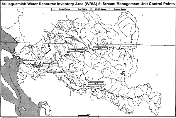
Table 1
Stream Management Unit Information
(N.F. is North Fork; S.F. is South Fork)
| Stream Management Unit Name | Control Point by River Mile (RM) or Latitude North (Lat.) and Longitude West (Long.) |
Stream Management Reach |
| Stillaguamish Mainstem | Stillaguamish River nr Silvana Ecology Station #05A070 RM 11.2 Lat. 48 11 49.5, Long. 122 12 32 | From the mouth at Port Susan to the confluence of the N.F. of the Stillaguamish River and the S.F. of the Stillaguamish River. |
| North Fork (N.F.) Stillaguamish River: | ||
| N.F. Stillaguamish River at Arlington, WA | USGS Station #12167000 RM 6.5 Lat. 48 15 42, Long. 122 02 47 | From confluence with the S.F. Stillaguamish to river mile 17.6. |
| N.F. Stillaguamish River at Oso | Ecology Station #05B090 RM 17.6 Lat. 48 16 21, Long. 122 53 17 | From river mile 17.6 to headwaters. |
| South Fork (S. F.) Stillaguamish River: | ||
| S.F. Stillaguamish River | RM 24.4 | From confluence with the N.F. Stillaguamish River to RM 34.9. |
| S.F. Stillaguamish River at Granite Falls, WA | USGS Station
#12161000 RM 34.9 Lat. 48 06 12, Long. 121 57 07 |
From S.F. Stillaguamish River at RM 34.9 to headwaters. |
| Stillaguamish River Tributaries: | ||
| Church Creek nr Stanwood | Ecology Station #05L070 RM 3 Lat. 48 14 54, Long. 122 18 48 | From mouth to headwaters, including tributaries. |
| Glade Bekken Creek - stream 0030 | At the Sylvania Terrace Rd. crossing RM 0.5 | From mouth to headwaters, including tributaries. |
| Portage Creek | At 208th St. NE & 66th Ave. crossing RM 7.0 | From mouth to headwaters, including tributaries. |
| Fish Creek | At Sill Rd. crossing RM 2.0 | From mouth to headwaters, including tributaries. |
| Pilchuck at Bridge 626 | Ecology Station #05D070 RM 0.5 Lat. 48 12 49, Long. 122 13 03 | From mouth to the Campground Bridge, including tributaries. |
| Pilchuck Creek above Lake Creek | Ecology Station #05D150 RM 17 Lat. 48 20 35, Long. 122 03 23 | From Campground Bridge to headwaters, except Lake Cavanaugh. |
| Pilchuck Creek Tributaries: | ||
| Lake Creek nr mouth | Ecology Station #05K060 RM 0.2 Lat. 48 20 29, Long. 122 03 18 | From mouth to headwaters, including tributaries, except Lake Cavanaugh. |
| North Fork (N. F.) Stillaguamish River Tributaries: | ||
| Squire Creek at Squire Creek Park | Ecology Station #05H070 RM 1.2 Lat. 48 16 13, Long. 121 40 17 | From mouth to headwaters, including tributaries. |
| Deer Creek nr Oso | Ecology Station #05C090 RM 1.3 Lat. 48 17 03, Long. 121 55 35 | From mouth to headwaters, including tributaries. |
| Brooks Creek | At Brooks Creek Rd. Bridge RM 0.3 | From mouth to headwaters, including tributaries. |
| Montague Creek | At Hwy 530 bridge RM 0.3 | From mouth to headwaters, including tributaries. |
| Rollins Creek | Off C Post off Hwy 530 about RM 1.0 | From mouth to headwaters, including tributaries. |
| Boulder River nr mouth | Ecology Station #05J060 RM 0.5 Lat. 48 16 40, Long. 121 46 52 | From mouth to headwaters, including tributaries. |
| French Creek | At Hwy 530 bridge RM 0.4 | From mouth to headwaters, including tributaries. |
| Segelson Creek | At Swede Haven Rd. bridge off Hwy 530 RM 0.3 | From mouth to headwaters, including tributaries. |
| Furland Creek | At Hwy 530 bridge RM 0.2 | From mouth to headwaters, including tributaries. |
| Ashton Creek | At Hwy 530 bridge RM 0.2 | From mouth to headwaters, including tributaries. |
| Grant Creek | At Hillis Rd. bridge off Hwy 530 RM 0.1 | From mouth to headwaters, including tributaries. |
| Rock Creek | At RM 1.1 | From mouth to headwaters, including tributaries. |
| Koonz Creek - Stream 0138 | At WDFW bridge RM 1.5 | From mouth to headwaters, including tributaries. |
| Harvey Creek | At side road crossing of Grandview Rd. RM 1.5 | From mouth to headwaters, including tributaries. |
| South Fork (S. F.) Stillaguamish River Tributaries: | ||
| Jim Creek at Whites Road | Ecology Station #05G070 RM 3.3 Lat. 48 10 41, Long. 122 03 07 | From mouth to headwaters, including tributaries. |
| Siberia Creek, tributary to Jim Creek | At mouth near 131st Ave. NE, RM 0.0 | From mouth to headwaters, including tributaries. |
| Canyon Creek nr Masonic Park | Ecology Station #05F080 RM 5.0 Lat. 48 07 17, Long. 121 54 17 | From mouth to headwaters, including tributaries. |
| Armstrong Creek | At Harvey Creek Rd. crossing RM 1.0 | From mouth to headwaters, including tributaries. |
| Jordan Creek | At Jordan Rd. crossing RM 0.1 | From mouth to headwaters, including tributaries. |
| Tiger Creek - stream 0363 | Near Masonic Park, RM 1.6 | From mouth to headwaters, including tributaries. |
[]
(2) Instream flows established in this section are water rights with a priority date the same as the effective date of this chapter.
(3) Instream flows are expressed in cubic feet per second (cfs). These flows are measured at the control points identified in WAC 173-505-040 and apply to the stream management reach. The instream flow provisions for any water right located in a stream management unit shall specifically describe the instream flow levels for the control station in that unit and shall refer generally to other downstream instream flow requirements that may also become controlling and critical to the use of water under such right.
(4) Instream flows are to be protected from impairment by junior water rights. Except as provided in WAC 173-505-080, 173-505-090, and 173-505-110, junior water rights shall be exercised only when flow conditions provide enough water to satisfy senior rights, including the instream flows set in this chapter. Withdrawals of water that would conflict with the established instream flows shall be authorized only in those situations where it is clear that overriding considerations of the public interest will be served.
(5) Stream flow requirements on existing water rights are not modified by this chapter. Existing water rights that include a provision that water use will be subject to future instream flows are now subject to the instream flows established in WAC 173-505-050.
(6) Instream flows are established for the stream management units in WAC 173-505-040, as follows:
Table 2
Instream Flows for the Mainstem and North and South Forks, Stillaguamish River
(in cubic feet per second) (RM=River Mile)
| Ecology Station #05A070 | USGS Station #12167000 |
Ecology Station #05B090 | USGS Station #12161000 | |||
| Month | Day | Stillaguamish RM 11.2 | North Fork Stillaguamish RM 6.5 | North Fork Stillaguamish RM 17.6 | South Fork Stillaguamish RM 24.4 | South Fork Stillaguamish RM 34.9 |
| Jan. | 1-31 | 2200 | 1200 | 915 | 1800 | 1200 |
| Feb. | 1-29 | 2000 | 1200 | 850 | 1600 | 1200 |
| Mar. | 1-15 | 2000 | 1300 | 850 | 2250 | 1600 |
| 16-31 | 2000 | 1300 | 915 | 2250 | 1600 | |
| Apr. | 1-30 | 2000 | 1300 | 915 | 2000 | 1600 |
| May | 1-31 | 2000 | 1300 | 915 | 2000 | 1600 |
| Jun. | 1-15 | 2000 | 1300 | 915 | 1200 | 1060 |
| 16-30 | 2000 | 1400 | 650 | 1200 | 1060 | |
| Jul. | 1-15 | 2000 | 1100 | 600 | 1150 | 1060 |
| 16-31 | 2000 | 800 | 500 | 750 | 700 | |
| Aug. | 1-15 | 1700 | 800 | 425 | 750 | 700 |
| 16-31 | 1700 | 800 | 500 | 750 | 700 | |
| Sep. | 1-15 | 1700 | 800 | 700 | 775 | 700 |
| 16-30 | 1700 | 800 | 850 | 775 | 700 | |
| Oct. | 1-15 | 1700 | 800 | 870 | 1250 | 1200 |
| 16-31 | 1700 | 800 | 870 | 1900 | 1700 | |
| Nov. | 1-15 | 2200 | 950 | 915 | 2300 | 1800 |
| 16-30 | 2200 | 950 | 915 | 2300 | 1800 | |
| Dec. | 1-31 | 2200 | 1300 | 915 | 2500 | 1800 |
Table 3
Instream Flows for Tributaries of
the Mainstem and North and South Forks Stillaguamish River Basin
(in cubic feet per second) (RM=River Mile)
| RM 0.5 | RM 17 | RM 1.2 | RM 3.3 | RM 5.0 | RM 0.3 | RM 1.3 | RM 0.3 | ||
| Month | Day | Pilchuck Creek | Pilchuck Creek | Squire Creek | Jim Creek | Canyon Creek | Lake Creek | Deer Creek | Brooks Creek |
| Jan. | 1-31 | 170 | 98 | 200 | 250 | 525 | 21 | 411 | 39 |
| Feb. | 1-29 | 170 | 98 | 200 | 250 | 450 | 21 | 411 | 39 |
| Mar. | 1-15 | 170 | 98 | 280 | 250 | 450 | 21 | 474 | 68 |
| Mar. | 16-31 | 170 | 98 | 280 | 250 | 450 | 21 | 474 | 68 |
| Apr. | 1-30 | 170 | 98 | 280 | 250 | 450 | 21 | 474 | 68 |
| May | 1-31 | 170 | 98 | 280 | 250 | 450 | 21 | 474 | 68 |
| Jun. | 1-15 | 170 | 98 | 280 | 250 | 450 | 21 | 313 | 45 |
| Jun. | 16-30 | 170 | 98 | 280 | 250 | 350 | 21 | 313 | 45 |
| Jul. | 1-31 | 170 | 98 | 200 | 250 | 350 | 21 | 195 | 45 |
| Aug. | 1-31 | 140 | 98 | 200 | 250 | 350 | 21 | 88 | 17 |
| Sep. | 1-30 | 170 | 98 | 200 | 250 | 400 | 21 | 353 | 17 |
| Oct. | 1-31 | 170 | 98 | 200 | 250 | 525 | 21 | 617 | 39 |
| Nov. | 1-15 | 170 | 98 | 160 | 250 | 525 | 21 | 411 | 39 |
| Nov. | 16-30 | 170 | 98 | 160 | 250 | 525 | 21 | 411 | 39 |
| Dec. | 1-31 | 170 | 98 | 160 | 250 | 525 | 21 | 411 | 39 |
Table 4
Instream Flows for Tributaries of
the Mainstem and North and South Forks Stillaguamish River Basin
(in cubic feet per second) (RM=River Mile)
| RM 0.3 | RM 1.0 | RM 0.5 | RM 0.4 | RM 0.3 | RM 0.2 | RM 0.2 | RM 0.1 | ||
| Month | Day | Montague Creek | Rollins Creek | Boulder Creek | French Creek | Segelson Creek | Furland Creek | Ashton Creek | Grant Creek |
| Jan. | 1-31 | 29 | 47 | 167 | 56 | 47 | 33 | 34 | 67 |
| Feb. | 1-29 | 29 | 47 | 167 | 56 | 47 | 33 | 34 | 67 |
| Mar. | 1-15 | 53 | 80 | 203 | 73 | 79 | 44 | 46 | 87 |
| Mar. | 16-31 | 53 | 80 | 203 | 73 | 79 | 44 | 46 | 87 |
| Apr. | 1-30 | 53 | 80 | 203 | 73 | 79 | 44 | 46 | 87 |
| May | 1-31 | 53 | 80 | 203 | 73 | 79 | 44 | 46 | 87 |
| Jun. | 1-15 | 35 | 53 | 134 | 48 | 52 | 29 | 30 | 57 |
| Jun. | 16-30 | 35 | 53 | 134 | 48 | 52 | 29 | 30 | 57 |
| Jul. | 1-31 | 35 | 53 | 134 | 48 | 52 | 29 | 30 | 57 |
| Aug. | 1-31 | 12 | 20 | 154 | 18 | 20 | 10 | 10 | 23 |
| Sep. | 1-30 | 12 | 47 | 250 | 84 | 47 | 49 | 51 | 101 |
| Oct. | 1-31 | 29 | 47 | 167 | 84 | 47 | 49 | 51 | 101 |
| Nov. | 1-15 | 29 | 47 | 167 | 56 | 47 | 33 | 34 | 67 |
| Nov. | 16-30 | 29 | 47 | 167 | 56 | 47 | 33 | 34 | 67 |
| Dec. | 1-31 | 29 | 47 | 167 | 56 | 47 | 33 | 34 | 67 |
Table 5
Instream
Flows for Tributaries of
the Mainstem and North and South Forks Stillaguamish River Basin
(in cubic feet per second) (RM=River Mile)
| RM 3.0 | RM 0.5 | RM 7.0 | RM 2.0 | RM 1.1 | RM 1.5 | ||
| Month | Day | Church Creek | Glade Bekken Creek | Portage Creek | Fish Creek | Rock Creek | Koonz Creek |
| Jan. | 1-31 | 24 | 10 | 11 | 16 | 29 | 19 |
| Feb. | 1-29 | 24 | 10 | 11 | 16 | 29 | 19 |
| Mar. | 1-15 | 43 | 21 | 22 | 30 | 53 | 36 |
| Mar. | 16-31 | 43 | 21 | 22 | 30 | 53 | 36 |
| Apr. | 1-30 | 43 | 21 | 22 | 30 | 53 | 36 |
| May | 1-31 | 43 | 21 | 22 | 30 | 53 | 36 |
| Jun. | 1-15 | 28 | 14 | 14 | 20 | 35 | 24 |
| Jun. | 16-30 | 28 | 14 | 14 | 20 | 35 | 24 |
| Jul. | 1-31 | 28 | 14 | 14 | 20 | 35 | 24 |
| Aug. | 1-31 | 10 | 4 | 4 | 6 | 12 | 8 |
| Sep. | 1-30 | 10 | 4 | 4 | 6 | 29 | 19 |
| Oct. | 1-31 | 24 | 10 | 11 | 16 | 29 | 19 |
| Nov. | 1-15 | 24 | 10 | 11 | 16 | 29 | 19 |
| Nov. | 16-30 | 24 | 10 | 11 | 16 | 29 | 19 |
| Dec. | 1-31 | 24 | 10 | 11 | 16 | 29 | 19 |
Table 6
Instream Flows for Tributaries of
the Mainstem and North and South Forks Stillaguamish River Basin
(in cubic feet per second) (RM=River Mile)
| RM 1.5 | RM 1.0 | RM 0.1 | RM 1.6 | RM 0.0 | ||
| Month | Day | Harvey Creek | Armstrong Creek | Jordan Creek | Tiger Creek | Siberia Creek |
| Jan. | 1-31 | 9 | 34 | 18 | 27 | 37 |
| Feb. | 1-29 | 9 | 34 | 18 | 27 | 37 |
| Mar. | 1-15 | 6 | 46 | 34 | 48 | 49 |
| Mar. | 16-31 | 6 | 46 | 34 | 48 | 49 |
| Apr. | 1-30 | 6 | 46 | 34 | 48 | 49 |
| May | 1-31 | 4 | 46 | 34 | 48 | 49 |
| Jun. | 1-15 | 4 | 30 | 22 | 32 | 32 |
| Jun. | 16-30 | 4 | 30 | 22 | 32 | 32 |
| Jul. | 1-31 | 4 | 30 | 22 | 32 | 32 |
| Aug. | 1-31 | 4 | 10 | 7 | 11 | 11 |
| Sep. | 1-30 | 4 | 51 | 18 | 11 | 27 |
| Oct. | 1-31 | 4 | 51 | 18 | 11 | 55 |
| Nov. | 1-15 | 9 | 34 | 18 | 27 | 37 |
| Nov. | 16-30 | 9 | 34 | 18 | 27 | 37 |
| Dec. | 1-31 | 9 | 34 | 18 | 27 | 37 |
[]
[]
(2) Exceptions to the closures and instream flow requirements are provided in WAC 173-505-070(3), 173-505-080, 173-505-090 and 173-505-110.
(3) The department finds that there is some water above the instream flows at specific locations and times of year that could be captured for storage or other projects that do not require year-round, noninterruptible water supplies. Therefore, the water sources described in the table below have water available for the time periods specified. These withdrawals are subject to the instream flows established in WAC 173-505-050 and the maximum allocations defined in WAC 173-505-100(2).
Table 7
Water Source and Open Periods*
| Water Source | Open Period | |
| Stillaguamish River from its multiple mouths at Port Susan to the confluence of N.F. Stillaguamish River and S.F. Stillaguamish River (RM 0 to 17.8). | October 16-June 30 | |
| N.F. Stillaguamish, from RM 0 (its confluence with the S.F. Stillaguamish) to river mile 17.6. | October 16-June 30 | |
| N.F. Stillaguamish River, from RM 17.6 to its headwaters. | November 1-June 30 | |
| S.F. Stillaguamish River from its confluence with the N.F. Stillaguamish River (RM 17.8) to RM 34.9. | November 1-June 15 | |
| Pilchuck Creek from mouth to RM 16.4 (confluence of Bear Creek). | October 16-May 31 | |
| Squire Creek from mouth to its headwaters. | November 1-February 15, and May 1-June 30 |
|
| Canyon Creek from mouth to RM 11.8 (confluence of N.F. Canyon Creek and S.F. Canyon Creek). | December 1-May 31 | |
| N.F. is North Fork | S.F. is South Fork | RM is river mile |
| *Tributaries to the water sources are excluded from the open period unless specifically listed. | ||
[]
(a) This surface water flow is available to satisfy stock watering requirements for stock on riparian grazing lands which drink directly from streams, lakes or other public waters. Appropriation or use of water from the reservation for stock watering shall be limited to the land base and carrying capacity of the grazing lands next to the stream or water course. The reservation shall not be available for feedlots and other activities which are not related to normal grazing land uses.
(b) The department encourages existing riparian stock water right holders to remove livestock from streams for the purpose of protecting water quality and stream habitat. Under these circumstances, no water right change application is required, as long as all of the following conditions are met:
(i) Small amounts of water are diverted (screened and piped) to nearby stock water tanks for consumption by livestock;
(ii) Stock water tanks shall be located close to the surface water source, and have as short a bypass reach as possible, while providing protection to the water body, stream bank and associated vegetative zone;
(iii) If a float or demand type valve is not used, the tank overflow must return to the same source, at or near the point of diversion;
(iv) The stock tank must serve stock, which normally range that parcel of property; and
(v) The quantity of water consumed from the stock tank should not exceed the quantity consumed if the stock drank directly from the stream.
(c) The decision by a person to divert stock water from the stream and into a tank does not constitute an adjudication of any claim to the right to the use of the water, as between the claimant and the state, or as between one or more water use claimants and another or others.
(2) The department reserves two acre-feet per year of ground water for future stock watering of up to five thousand gallons per day for individual users.
(3) The department will maintain an estimate of the amount of water used from the reservation, and reserves the right to require metering and reporting of water use to ensure compliance with the conditions of use for stock watering under this section.
[]
Based on this finding, the department hereby allocates a total amount of water not to exceed five cubic feet per second (5 cfs) to provide adequate and safe supplies of water for year-round future domestic uses. Of that 5 cfs, the reservation is further defined by limits on the amount of reserved water that can be withdrawn from the North and South Forks of the Stillaguamish River, as identified in the following table.
This reservation of ground water is not subject to the instream flows established in WAC 173-505-050 or the stream closures established in WAC 173-505-070.
Table 8
Allocation of Reservation as Measured at Specified River
Miles
| Water Source (RM - River Mile) | Amount of Water Available, Measured in Cubic Feet per Second (cfs) and Gallons per Day (gpd) |
| Stillaguamish River at RM 11.2 | 5 cfs or 3.23 million gpd |
| Of that 5 cfs, the following maximums may be taken from the specified locations: | |
| North Fork Stillaguamish River at RM 6.5 | 2 cfs or 1,292,544 gpd |
| South Fork Stillaguamish River at RM 24.4 | 1.5 cfs or 969,408 gpd |
(a) The water reserved shall be for ground water uses exempt from a water right permit application. This reservation can provide water for either single or small group domestic uses, as defined in WAC 173-505-030(5).
(b) This reservation of ground water shall not exceed 3.23 million gallons of water per day (5 cfs).
(c) Domestic water use shall meet the water use efficiency standards of the uniform plumbing code as well as any applicable local or state requirements for conservation standards.
(d) This reservation shall only be applicable in areas where all of the following conditions exist:
(i) An ordinance or other administrative action is established by the appropriate city or county that provides that the same requirements as (a), (b), (c), (e), (f), (g) and (h) of this subsection shall be conditions within a building permit or subdivision approval if the water adequacy finding for such permit or approval is based upon the reservation contained herein;
(ii) It shall be the responsibility of an applicant for a building permit or subdivision approval seeking water under the reservation to comply with the conditions in (a), (b), (c), (e), (f), (g) and (h) of this subsection and all other conditions of this chapter.
(e) A new water withdrawal under this reservation is not allowed in those areas where a public water system has been established, and where the connection can be provided in a timely and reasonable manner.
(f) If a public water system becomes available after the effective date of this chapter to persons using water under the reservation, and the connection can be provided in a timely and reasonable manner, those persons must connect to the public water system. Any such persons must take affirmative action to connect to the public water system no later than one hundred twenty days after receiving the department's written order to cease and desist use of the well.
(g) Outdoor water use is limited to the watering of an outdoor area not to exceed a total of 1/12th of an acre for all outdoor uses under each individual domestic water use. Under all circumstances, total outdoor watering for multiple residences under the permit exemption (RCW 90.44.050) shall not exceed one-half acre.
(h) The department reserves the right to require metering and reporting of water use for single domestic users, if more accurate water use data is needed for management of the reservation and water resources in the area of the reservation. All other ground water users under the permit-exemption shall be required to install and maintain measuring devices, in accordance with specifications provided by the department, and report the data to the department.
(3) Once this chapter is adopted, the department will promptly notify the appropriate county or counties, water well contractors and the public of the restrictions on future permitted and permit-exempt water withdrawals, availability of water from the reservation and the specific requirements that an applicant obtaining a building permit or subdivision approval must comply with.
(4) The reservation is a one-time, finite amount of water. Once the reservation is fully allocated, it is no longer available. Other water sources may be available only under the provisions in WAC 173-505-110, 173-505-120, 173-505-130 and 173-505-140.
(a) The department shall notify the appropriate county, in writing, when it determines that fifty percent, seventy-five percent, and one hundred percent of the reservation has been allocated. The department shall also issue a public notice annually in a newspaper of general circulation for the region that shows the amounts of reserved water that have been allocated and what remains unallocated, as well as identifying any water source that has been fully allocated and from which water is no longer available under this reservation.
(b) The county or city shall provide ecology with an annual report on the number of building permits and subdivision approvals that will use water from the reservation. This report must also identify the type of use associated with each approval.
(5) If a water use is not in compliance with any condition of this reservation, the department may take action consistent with WAC 173-505-150.
(6) If existing county and city land use decisions, including zoning changes and building permit and subdivision approvals, allow for uses inconsistent with this chapter or for increased densities that adversely affect small tributaries and other flow-sensitive areas, the department may limit or restrict the further use of the reservation. The department will promptly notify the appropriate county or counties, water well contractors and the public of any changes to use of the reservation.
(7)(a) A record of all ground water withdrawals from the reservation shall be maintained by the department. The record will readily show both the allocated and unallocated quantities of ground water that are in reserved status. For accounting purposes, the department may use three hundred fifty gallons per day (gpd) per residence or business as the average water use value. This figure may be adjusted down to one hundred seventy-five gpd if the residence or business is served by an on-site septic system, to take recharge into account.
(b) If an entity using water under this reservation subsequently abandons the withdrawal and notifies the department, the water use may be credited back to the reservation.
[]
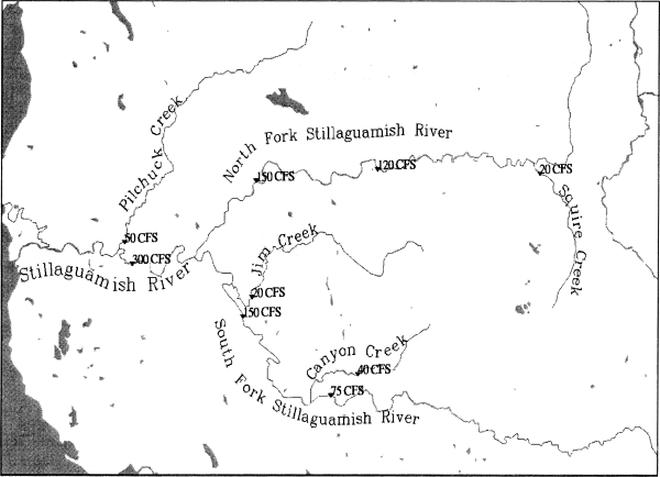
(2) Therefore, the department determines that the total consumptive withdrawals from existing and future water rights in the Stillaguamish River basin during open periods shall not exceed a total of 300 cubic feet per second (cfs) as measured at USGS gauge #12167700, river mile 11.2. Of that 300 cfs, the maximum allocation is further defined by limits on the amount of water that can be withdrawn from specified stream reaches, at specific times. Refer to the table and map, below.
Table 9
Maximum Allocation
| Water Source* | Open Period | |
| Stillaguamish River from its multiple mouths at Port Susan to the confluence of N.F. Stillaguamish River and S.F. Stillaguamish River (RM 0 to 17.8). | October 16-June 30 | |
| Maximum Allocation 300 cfs | ||
| Of that 300 cfs, the following maximums may be taken from the specified stream reaches at the specified times: | ||
| N.F. Stillaguamish, from RM 0 (its confluence with the S.F. Stillaguamish) to river mile 17.6. | October 16-June 30 | |
| Maximum Allocation 150 cfs | ||
| N.F. Stillaguamish River, from RM 17.6 to its headwaters. | November 1-June 30 | |
| Maximum Allocation 120 cfs | ||
| S.F. Stillaguamish River from its confluence with the N.F. Stillaguamish River (RM 17.9) to RM 34.9. | November 1-June 15 | |
| Maximum Allocation 150 cfs | ||
| Pilchuck Creek from mouth to RM 16.4 (confluence of Bear Creek). | October 16-May 31 | |
| Maximum Allocation 50 cfs | ||
| Squire Creek from mouth to its headwaters. | November 1-February 15, and May 1-June 30 | |
| Maximum Allocation 20 cfs | ||
| Canyon Creek from mouth to RM 11.8 (confluence of N.F. Canyon Creek and S.F. Canyon Creek). | December 1-May 31 | |
| Maximum Allocation 40 cfs | ||
| N.F. is North Fork | S.F. is South Fork | RM is river mile |
| * | Tributaries to the water sources are excluded from the open period unless specifically listed. |
Maximum allocations for specific stream reaches (listed above) in the Stillaguamish River basin, measured at designated control points
|
(4) The department will maintain a record of the amount of water allocated from all water rights in the Stillaguamish River basin, including those existing prior to the effective date of this chapter. When the maximum allocation is fully appropriated for any river, river reach, or stream, the department shall notify the appropriate county, in writing. The department shall also issue a public notice in a newspaper of general circulation for the region stating the maximum allocation is fully allocated.
[]
(a) The proposed use is nonconsumptive, and compatible with the intent of this chapter.
(b) The applicant elects to submit a scientifically sound mitigation plan, as defined in WAC 173-505-030(7), and it is approved by the department. If monitoring of a mitigation plan shows the mitigation is not effective, use of water under the permit shall then be subject to the instream flows. In the case of a closed stream, the use shall cease until a more effective mitigation plan is put in place.
(c) The proposed ground water use will not impair senior water rights. Based on the hydrogeology of the basin, and the location and depth where ground water withdrawals generally occur, future ground water withdrawals have a high likelihood of capturing water that would result in impacts to surface water flows and levels in the Stillaguamish River basin. Therefore, a ground water permit that is not subject to the instream flows or closures may only be approved if an applicant can demonstrate, through additional studies and technical analysis, and to the satisfaction of the department, that the proposed use will not cause impairment to existing water rights, including the instream flows set in this chapter.
(d) Before the department can approve a water right application for a new public water system under (b) and (c) of this subsection, the applicant must also demonstrate that there are no other public water systems in the same proposed retail service area that can provide water in a timely and reasonable manner. If domestic potable water can be provided in a timely and reasonable manner by another public water system, the department shall reject the water right application.
(e) The proposed use is for a salmon recovery project recommended for approval by the department of fish and wildlife.
(2) All water right permits approved by the department for a consumptive use from a water source with instream flows established by this chapter and during open periods are subject to those instream flows, as established in WAC 173-505-050. In addition, the total appropriation cannot exceed the maximum allocation limits described in WAC 173-505-100.
(3) No right to withdraw, divert or store the public surface or ground waters of the Stillaguamish River basin that conflicts with the provisions of this chapter will hereafter be granted, except in cases where such rights will clearly serve overriding considerations of the public interest, as stated in RCW 90.54.020 (3)(a).
(4) All future surface and ground water permit holders shall be required to install and maintain measuring devices, in accordance with specifications provided by the department, and report the data to the department in accordance with the permit requirements. In addition, the department may require the permit holder to monitor stream flows and ground water levels.
[]
• Reuse of reclaimed water;
• Artificial recharge and recovery;
• Multipurpose water storage facilities;
• Conservation and efficiency measures applied to existing uses and the transfer of saved water;
• Acquisition of existing water rights; and
• Establishment of a trust water rights program.
(2) Alternative sources of water of equal or better quality than the proposed source can be used to improve stream flows for fish, offset impacts of withdrawals on stream flows and provide sources of water for future out-of-stream uses.
[]
(2) The determination of how much water should be allocated between future out-of-stream uses and the restoration and enhancement of instream flows will be made at the time the water is acquired and deposited into the trust water rights program.
[]
[]
(2) When the department determines that a violation has occurred, it shall:
(a) First attempt to achieve voluntary compliance. An approach to achieving this is to offer information and technical assistance to the person, in writing, identifying one or more means to accomplish the person's purposes within the framework of the law.
(b) If education and technical assistance do not achieve compliance, the department shall issue a notice of violation, a formal administrative order under RCW 43.27A.190, or assess penalties under RCW 43.83B.336, 90.03.400, 90.03.410, 90.03.600, 90.44.120 and 90.44.130.
[]
[]
[]
 |
[]