PERMANENT RULES
Effective Date of Rule: Thirty-one days after filing.
Purpose: The purpose of this new rule, chapter 173-505 WAC, is to establish a water right for instream flows to satisfy the statutory directive, chapter 90.54 RCW, to protect instream resources of wildlife, fish, water quality, navigation, recreation, scenic, aesthetics and other environmental values. The rule also will guide future water resource management in the Stillaguamish River basin, WRIA 5. The rule was developed by the Department of Ecology in conjunction with the Stillaguamish River Implementation Review Committee (SIRC). SIRC committee members consist of representatives from the Stillaguamish Indian tribe, regional salmon recovery groups, federal and local governments.
Statutory Authority for Adoption: Chapters 43.27A, 90.54, 90.22, and 90.82 RCW.
Adopted under notice filed as WSR 05-09-124 on April 20, 2005.
Changes Other than Editing from Proposed to Adopted Version: WAC 173-505-010 General. In subsection (2)(b) the last half of the second sentence was deleted. The change was made to clarify the relationship of hydraulic continuity, impairment of instream flows, and provisions for junior water rights. The determination of hydraulic continuity and determination of impairment (effect on the flow or level of a stream or river) are two different questions. The presumption of hydraulic continuity was struck, as it is a fact specific inquiry.
WAC 173-505-020 Purpose. In subsection (2), the word reservation was made plural. The change was made because there are two stockwatering reservations. In subsection 3, the last sentence was modified to clearly state the rule's requirements do not replace statutory requirements. A commentator thought the rule supplanted or replace the statutory criteria for water right decision making and that is not the case. A sentence was added that the rule does not relieve anyone from compliance with relevant statutory requirements.
WAC 173-505-030 Definitions. A second sentence was added to the introductory language to clearly state that definitions in this section, if they are different than how the word is described in other water rules, are used for this chapter. The sentence added is "In the event that these definitions differ from those contained in related rules, the definitions presented here will supersede any others for this chapter."
The definition of "municipal water supplier" from the statute was added because we deleted a definition of "public water supply." The term "municipal water supplier" is more precise and comports with the Municipal Water Law of 2003. The definition was added to facilitate users being able to locate terms instead of providing a statutory reference.
The definition of "municipal water supply purposes" from the statute was added because we deleted a definition of "public water supply." The term "municipal water supply purposes" is more precise than "public water supply" and comports with the Municipal Water Law of 2003. The definition was added to facilitate users being able to locate terms instead of providing a statutory reference.
The definition of "public water system" was deleted and replace with "municipal water supplier." Some public water systems are not municipal water suppliers and that caused some commenter confusion related to the policy of requiring connection to public water system as compared to a municipal water supplier.
The definition of "reservation" was modified to more clearly state the effective date of a reservation, as well as the priority date of a given appropriation from a reservation, is the same as the effective date of this chapter.
The definition of "timely and reasonable" was deleted. The term as defined in the original proposal did not comport with the term as used and defined by Department of Health. The term is also one part of a municipal water suppliers' duty to serve under RCW 43.20.260. To avoid confusion, we deleted the version in the rule.
WAC 173-505-040 Establishment of stream management units. The location description of the Jim Creek station had the wrong longitude. The longitude in the proposed rule was 122 03 07. The correct longitude is 122 03 06. The location of the station did not change.
WAC 173-505-070 Stream closures. In subsection (1) the language on hydraulic continuity of ground water and closure of surface water was clarified. The closure applies to ground water the withdrawal of which will have an effect on the flow or level of the rivers and streams.
In subsection (2) we list the exceptions to the closures. Originally, ecology did not list WAC 173-505-060, lakes, because a lake is not a stream. However, a commenter was confused as to whether or not lakes were subject to the closure. Lakes are not subject to the closure so we added WAC 173-505-060 to the list of sections excepted from the closure to clearly state that lakes are not closed.
In subsection (3), first sentence, we changed the word "noninterruptable" to be "uninterruptible." The change was made for consistency because uninterruptible is the word used in the rest of the chapter. The words mean the same thing.
WAC 173-505-080 Future stock watering. In subsection (1)(b) the second sentence was changed to read "Uses that meet the following conditions shall be considered to qualify as direct stock watering from a stream:" The change was made to recognize that stockwatering tanks that meet the criteria of the rule are recognizes [recognized] as a direct diversion and not a change of water right.
In subsection (2), the volume of the reserve was changed from two to twenty. An error was discovered in calculating the reserve. The change of two to twenty is substantially different from the proposed rule. The effect of the change is to allow more stockwatering in the future than would have been satisfied with two acre-feet. Also in subsection (2) the language related to a daily limit on use of water the ground water reserve was deleted. The language deleted is "of up to five thousand gallons per day for individual users." The language was deleted because of a recent attorney general's informal opinion that stockwatering via the ground water permit exempt well is unlimited as to a daily volume. The informal opinion is contrary to previous guidance on this issue. Because of the uncertainty surrounding this issue the language was removed.
WAC 173-505-090 Reservation of permit-exempt ground water for future domestic uses. Subsection (2)(a) was modified to more clearly state the water from the reservation is for single or group domestic use. The new language is "This reservation is for either single or small group domestic uses, as defined in WAC 173-505-030(5)."
A new subsection (2)(d) was written to replace old subsection (2)(d)(i) to reflect the policy local government's recognize the reservation to activate it if they make decisions regarding water supply for buildings requiring potable water or a decision on the platting of property and the project proponent will use water from the reserve. This idea was in the original proposed rule as requiring local governments to make the terms and conditions of the reservation a term and condition of a building permit. That language was deleted.
Subsection (2)(e) was modified to clearly state that an applicant for a building permit or subdivision approval proposing a water use under the reservation must comply with the terms of the reservation. The reference to subsection "b" was deleted as it is not applicable to the water user.
A new subsection (2)(f) was drafted to replace old subsection (2)(e) to make a better connection to the RCW 43.20.260 and the Municipal Water Law of 2003. The policy or requirement is the same; the new language is more precise and removed confusion regarding public water systems that are not subject to RCW 43.20.260.
The old subsection (2)(f) was deleted in response to commentators who said it was unreasonable, unworkable and could not be enforced. This is the section of the proposed rule that would have required water wells constructed after the effective date of the rule, and within the service area of a public water system to be abandoned if public water supply was extended into the area. Ecology recognized it was problematic and deleted the language.
The old subsection (3) related to ecology providing notice of the reservation was deleted. The same idea with different language is reflected in new subsection (2)(d). In the proposed subsection (4), second sentence, the word "only" was struck from the sentence. The word was struck because the list of other water sources was not exclusive. There are other ways to meet water needs than "only" the ones listed.
In subsection (4)(b) the language "The county or city shall provide ecology with an annual report on the number of building permits and subdivision approvals that will use water from the reservation. This report must also identify the type of use associated with each approval." was deleted. Several comments noted the language appeared to be an unfunded mandate from the state and or the state was trying to get the local governments to do the reservation accounting. It was also noted that ecology lacked statutory authority to compel the local governments to provide the data. It was not and is not ecology's intent to have the local governments do the reservation accounting. To avoid confusion, the language was deleted. Ecology will still use the information from the local governments; however, it is not a requirement of the rule.
Proposed subsection (6) was deleted because of confusion it created. The policy is that if conditions change, ecology will reevaluate the reservation of water and its use. Ecology was not specific that this reevaluation would be done by rule making. The subsection was deleted since proposed WAC 173-505-170 Regulation review, provides for an opportunity to review the rule. The deleted language was duplicative.
Subsection 070(a) [(7)(a)] was modified to add the idea that accounting for water use under the reservation can include empirical data on actual water use.
WAC 173-505-100 Maximum allocations. In subsection (2), first sentence, the reference to a USGS gage on the Stillaguamish River at Silvana was changed to refer to an ecology gage at the same location.
Subsection (3) was modified to clearly state that existing water rights are not subject to instream flow requirements. The language created confusion as to whether or not existing rights would be subject to instream flows. That is not the case. The proposed rule in WAC 173-505-010(3) says existing rights are not affected. For the rule to be internally consistent, consistent with statutes, and avoid confusion, the change was made.
WAC 173-505-110 Future permitting actions. In subsection (1)(c) the word "additional" was deleted. The word implied that existing studies may not be sufficient and that is not the case. To avoid confusion the change was made.
WAC 173-505-120 Alternative sources of water. In subsection (2) the words "the proposed" was replaced with "a new." The originally proposed language was not clear that alternative sources of water can be used instead of a new source.
A final cost-benefit analysis is available by contacting Cathy Carruthers, P.O. Box 47600, Olympia, WA 98504-7600, phone (360) 407-6564, fax (360) 407-6989, e-mail caca461@ecy.wa.gov.
Number of Sections Adopted in Order to Comply with Federal Statute: New 0, Amended 0, Repealed 0; Federal Rules or Standards: New 0, Amended 0, Repealed 0; or Recently Enacted State Statutes: New 18, Amended 0, Repealed 0.
Number of Sections Adopted at Request of a Nongovernmental Entity: New 0, Amended 0, Repealed 0.
Number of Sections Adopted on the Agency's Own Initiative: New 0, Amended 0, Repealed 0.
Number of Sections Adopted in Order to Clarify, Streamline, or Reform Agency Procedures: New 0, Amended 0, Repealed 0.
Number of Sections Adopted Using Negotiated Rule Making: New 0, Amended 0, Repealed 0; Pilot Rule Making: New 0, Amended 0, Repealed 0; or Other Alternative Rule Making: New 0, Amended 0, Repealed 0.
Date Adopted: August 26, 2005.
Jay J. Manning
Director
OTS-7738.8
INSTREAM RESOURCES PROTECTION AND WATER RESOURCES PROGRAM
Water Resources Inventory Area (WRIA) 5
NEW SECTION
WAC 173-505-010
General provisions -- Authority and
applicability.
(1) This chapter is adopted under the
authority of the Water Resources Act of 1971 (chapter 90.54 RCW), Minimum Water Flows and Levels Act (chapter 90.22 RCW),
Water Well Construction Act (chapter 18.104 RCW), Water
resource management (chapter 90.42 RCW), Regulation of public
ground waters (chapter 90.44 RCW), and Water resources
management program (chapter 173-500 WAC).
(2) This chapter applies to the use and appropriation of:
(a) All surface waters that drain within the Stillaguamish River basin, also known as water resources inventory area (WRIA) 5, including its tributaries and areas adjacent to the mouth of the Stillaguamish River that drain to salt water; and
(b) All ground water hydraulically connected with surface waters of the Stillaguamish River basin. Existing studies indicate a substantial likelihood that all waters within WRIA 5 are in hydraulic continuity with the surface waters covered herein.
(3) This chapter shall not affect existing water rights, including perfected riparian rights or other appropriative rights existing on the effective date of this chapter, unless otherwise provided for in the conditions of the water right in question.
(4) This chapter shall also not affect federal Indian and non-Indian reserved rights. The Stillaguamish Tribe of Indians and the Tulalip Tribes reserve the right to a claim for a treaty-derived off-reservation instream flow right with senior priority. The extent of such rights can only be adjudicated in federal or state court.
(5) This chapter does not limit the department's authority to establish instream flow requirements or conditions under other laws, including hydropower licensing under RCW 90.48.260.
(6) In accordance with RCW 90.54.090, all agencies of state and local government, including counties and municipal and public corporations, shall, whenever possible, carry out powers vested in them in manners which are consistent with this chapter.
(7) In administering and enforcing this chapter, the department's actions shall be consistent with the provisions of chapter 90.54 RCW.
[]
(2) The chapter creates a reservation of adequate and safe supplies of potable water to satisfy human domestic needs, and reservations for stock watering.
(3) This chapter sets forth the department's policies to guide the protection, utilization and management of Stillaguamish River basin surface water and interrelated ground water resources. It establishes instream flows and closures, and sets forth a program for administration of future water allocation and use. This chapter does not relieve anyone from compliance with relevant statutory requirements.
[]
(1) "Allocation" means the designating of specific amounts of water for specific beneficial uses.
(2) "Appropriation" means the process of legally acquiring the right to specific amounts of water for beneficial uses, as consistent with the requirements of the ground and surface water codes and other applicable water resource statutes. This term refers to both surface and ground water right permits and to ground water withdrawals otherwise exempted from permit requirements under RCW 90.44.050.
(3) "Consumptive use" means a use of water that diminishes the amount or quality of water in the water source.
(4) "Department" means the Washington state department of ecology.
(5) "Domestic water use" means, for the purposes of administering WAC 173-505-090, potable water to satisfy the human domestic needs of a household or business, including water used for drinking, bathing, sanitary purposes, cooking, laundering, and other incidental uses. Outdoor watering shall be limited to an area not to exceed a total of 1/12th of an acre, or three thousand six hundred thirty square feet, for all outdoor uses for each individual domestic water use. Under all circumstances, total outdoor watering for multiple residences under the permit exemption (RCW 90.44.050) shall not exceed one-half acre.
(6) "Instream flow" means a stream flow level set in rule that is required to protect and preserve fish, wildlife, scenic, aesthetic and other environmental values, and navigational values. The term "instream flow" means a base flow under chapter 90.54 RCW, a minimum flow under chapter 90.03 or 90.22 RCW, or a minimum instream flow under chapter 90.82 RCW.
(7) "Mitigation plan" means a scientifically sound plan voluntarily submitted by a project proponent to offset the impacts of a proposed water use and approved by the department. A mitigation plan can be submitted to the department for a stream, basin, reach, or other area. A mitigation plan must show that the withdrawal with mitigation in place will not impair existing water rights, including instream flow rights, or diminish water quality. The plan must provide mitigation for the duration of the water use.
(8) "Municipal water supplier" means an entity that supplies water for municipal water supply purposes. (RCW 90.03.015.)
(9) "Municipal water supply purposes" means a beneficial use of water: (a) For residential purposes through fifteen or more residential service connections or for providing residential use of water for a nonresidential population that is, on average, at least twenty-five people for at least sixty days a year; (b) for governmental or governmental proprietary purposes by a city, town, public utility district, county, sewer district, or water district; or (c) indirectly for the purposes in (a) or (b) of this subsection through the delivery of treated or raw water to a public water system for such use. (Partial definition; for the complete text of this definition refer to RCW 90.03.015.)
(10) "Nonconsumptive use" means a use of water that does not diminish the amount or quality of water in the water source.
(11) "Permit-exempt withdrawals" or "permit exemption" means a ground water withdrawal exempted from permit requirements under RCW 90.44.050, but which is otherwise subject to the ground water code.
(12) "Reservation" means an allocation of water for future beneficial uses. The effective date of a reservation, as well as the priority date of a given appropriation from a reservation, is the same as the effective date of this chapter.
(13) "Stream management unit" means a stream segment, reach, or tributary used to describe the part of the relevant stream to which a particular instream flow level applies.
(14) "Withdrawal" means the appropriation or use of ground water, or the diversion or use of surface water.
[]
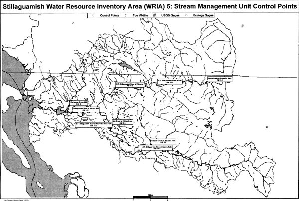
Table 1
Stream Management Unit Information
(N.F. is North Fork; S.F. is South Fork)
| Stream Management Unit Name | Control Point by River Mile (RM) or Latitude North (Lat.) and Longitude West (Long.) |
Stream Management Reach |
| Stillaguamish Mainstem | Stillaguamish
River nr
Silvana
Ecology
Station
#05A070 RM 11.2 Lat. 48 11 49.5, Long. 122 12 32 |
From the mouth at Port Susan to the confluence of the N.F. of the Stillaguamish River and the S.F. of the Stillaguamish River. |
| North Fork (N.F.) Stillaguamish River: | ||
| N.F. Stillaguamish River at Arlington, WA | USGS Station
#12167000 RM 6.5 Lat. 48 15 42, Long. 122 02 47 |
From confluence with the S.F. Stillaguamish to river mile 17.6. |
| N.F. Stillaguamish River at Oso | Ecology
Station
#05B090 RM 17.6 Lat. 48 16 21, Long. 122 53 17 |
From river mile 17.6 to headwaters. |
| South Fork (S. F.) Stillaguamish River: | ||
| S.F. Stillaguamish River | RM 24.4 | From confluence with the N.F. Stillaguamish River to RM 34.9. |
| S.F. Stillaguamish River at Granite Falls, WA | USGS Station
#12161000 RM 34.9 Lat. 48 06 12, Long. 121 57 07 |
From S.F. Stillaguamish River at RM 34.9 to headwaters. |
| Stillaguamish River Tributaries: | ||
| Church Creek nr Stanwood | Ecology
Station
#05L070 RM 3 Lat. 48 14 54, Long. 122 18 48 |
From mouth to headwaters, including tributaries. |
| Glade Bekken Creek - stream 0030 | At the Sylvania Terrace Rd. crossing RM 0.5 | From mouth to headwaters, including tributaries. |
| Portage Creek | At 208th St. NE & 66th Ave. crossing RM 7.0 | From mouth to headwaters, including tributaries. |
| Fish Creek | At Sill Rd. crossing RM 2.0 | From mouth to headwaters, including tributaries. |
| Pilchuck at Bridge 626 | Ecology
Station
#05D070 RM 0.5 Lat. 48 12 49, Long. 122 13 03 |
From mouth to the Campground Bridge, including tributaries. |
| Pilchuck Creek above Lake Creek | Ecology
Station
#05D150 RM 17 Lat. 48 20 35, Long. 122 03 23 |
From Campground Bridge to headwaters, except Lake Cavanaugh. |
| Pilchuck Creek Tributaries: | ||
| Lake Creek nr mouth | Ecology
Station
#05K060 RM 0.2 Lat. 48 20 29, Long. 122 03 18 |
From mouth to headwaters, including tributaries, except Lake Cavanaugh. |
| North Fork (N. F.) Stillaguamish River Tributaries: | ||
| Squire Creek at Squire Creek Park | Ecology
Station
#05H070 RM 1.2 Lat. 48 16 13, Long. 121 40 17 |
From mouth to headwaters, including tributaries. |
| Deer Creek nr Oso | Ecology
Station
#05C090 RM 1.3 Lat. 48 17 03, Long. 121 55 35 |
From mouth to headwaters, including tributaries. |
| Brooks Creek | At Brooks Creek Rd. Bridge RM 0.3 | From mouth to headwaters, including tributaries. |
| Montague Creek | At Hwy 530 bridge RM 0.3 | From mouth to headwaters, including tributaries. |
| Rollins Creek | Off C Post off Hwy 530 about RM 1.0 | From mouth to headwaters, including tributaries. |
| Boulder River nr mouth | Ecology
Station
#05J060 RM 0.5 Lat. 48 16 40, Long. 121 46 52 |
From mouth to headwaters, including tributaries. |
| French Creek | At Hwy 530 bridge RM 0.4 | From mouth to headwaters, including tributaries. |
| Segelson Creek | At Swede Haven Rd. bridge off Hwy 530 RM 0.3 | From mouth to headwaters, including tributaries. |
| Furland Creek | At Hwy 530 bridge RM 0.2 | From mouth to headwaters, including tributaries. |
| Ashton Creek | At Hwy 530 bridge RM 0.2 | From mouth to headwaters, including tributaries. |
| Grant Creek | At Hillis Rd. bridge off Hwy 530 RM 0.1 | From mouth to headwaters, including tributaries. |
| Rock Creek | At RM 1.1 | From mouth to headwaters, including tributaries. |
| Koonz Creek - Stream 0138 | At WDFW bridge RM 1.5 | From mouth to headwaters, including tributaries. |
| Harvey Creek | At side road crossing of Grandview Rd. RM 1.5 | From mouth to headwaters, including tributaries. |
| South Fork (S. F.) Stillaguamish River Tributaries: | ||
| Jim Creek at Whites Road | Ecology
Station
#05G070 RM 3.3 Lat. 48 10 41, Long. 122 03 06 |
From mouth to headwaters, including tributaries. |
| Siberia Creek, tributary to Jim Creek | At mouth near 131st Ave. NE, RM 0.0 | From mouth to headwaters, including tributaries. |
| Canyon Creek nr Masonic Park | Ecology
Station
#05F080 RM 5.0 Lat. 48 07 17, Long. 121 54 17 |
From mouth to headwaters, including tributaries. |
| Armstrong Creek | At Harvey Creek Rd. crossing RM 1.0 | From mouth to headwaters, including tributaries. |
| Jordan Creek | At Jordan Rd. crossing RM 0.1 | From mouth to headwaters, including tributaries. |
| Tiger Creek - stream 0363 | Near Masonic Park, RM 1.6 | From mouth to headwaters, including tributaries. |
[]
(2) Instream flows established in this section are water rights with a priority date the same as the effective date of this chapter.
(3) Instream flows are expressed in cubic feet per second (cfs). These flows are measured at the control points identified in WAC 173-505-040 and apply to the stream management reach. The instream flow provisions for any water right located in a stream management unit shall specifically describe the instream flow levels for the control station in that unit and shall refer generally to other downstream instream flow requirements that may also become controlling and critical to the use of water under such right.
(4) Instream flows are to be protected from impairment by junior water rights. Except as provided in WAC 173-505-080, 173-505-090, and 173-505-110, junior water rights shall be exercised only when flow conditions provide enough water to satisfy senior rights, including the instream flows set in this chapter. Withdrawals of water that would conflict with the established instream flows shall be authorized only in those situations where it is clear that overriding considerations of the public interest will be served.
(5) Stream flow requirements on existing water rights are not modified by this chapter. Existing water rights that include a provision that water use will be subject to future instream flows are now subject to the instream flows established in WAC 173-505-050.
(6) Instream flows are established for the stream management units in WAC 173-505-040, as follows:
Table 2
Instream Flows for the Mainstem and North and South Forks, Stillaguamish River
(in cubic feet per second) (RM=River Mile)
| Ecology Station #05A070 | USGS Station #12167000 |
Ecology Station #05B090 | USGS Station #12161000 | |||
| Month | Day | Stillaguamish RM 11.2 | North Fork Stillaguamish RM 6.5 | North Fork Stillaguamish RM 17.6 | South Fork Stillaguamish RM 24.4 | South Fork Stillaguamish RM 34.9 |
| Jan. | 1-31 | 2200 | 1200 | 915 | 1800 | 1200 |
| Feb. | 1-29 | 2000 | 1200 | 850 | 1600 | 1200 |
| Mar. | 1-15 | 2000 | 1300 | 850 | 2250 | 1600 |
| 16-31 | 2000 | 1300 | 915 | 2250 | 1600 | |
| Apr. | 1-30 | 2000 | 1300 | 915 | 2000 | 1600 |
| May | 1-31 | 2000 | 1300 | 915 | 2000 | 1600 |
| Jun. | 1-15 | 2000 | 1300 | 915 | 1200 | 1060 |
| 16-30 | 2000 | 1400 | 650 | 1200 | 1060 | |
| Jul. | 1-15 | 2000 | 1100 | 600 | 1150 | 1060 |
| 16-31 | 2000 | 800 | 500 | 750 | 700 | |
| Aug. | 1-15 | 1700 | 800 | 425 | 750 | 700 |
| 16-31 | 1700 | 800 | 500 | 750 | 700 | |
| Sep. | 1-15 | 1700 | 800 | 700 | 775 | 700 |
| 16-30 | 1700 | 800 | 850 | 775 | 700 | |
| Oct. | 1-15 | 1700 | 800 | 870 | 1250 | 1200 |
| 16-31 | 1700 | 800 | 870 | 1900 | 1700 | |
| Nov. | 1-15 | 2200 | 950 | 915 | 2300 | 1800 |
| 16-30 | 2200 | 950 | 915 | 2300 | 1800 | |
| Dec. | 1-31 | 2200 | 1300 | 915 | 2500 | 1800 |
Table 3
Instream Flows for Tributaries of
the Mainstem and North and South Forks Stillaguamish River Basin
(in cubic feet per second) (RM=River Mile)
| RM 0.5 | RM 17 | RM 1.2 | RM 3.3 | RM 5.0 | RM 0.3 | RM 1.3 | RM 0.3 | ||
| Month | Day | Pilchuck Creek | Pilchuck Creek | Squire Creek | Jim Creek |
Canyon Creek | Lake Creek | Deer Creek | Brooks Creek |
| Jan. | 1-31 | 170 | 98 | 200 | 250 | 525 | 21 | 411 | 39 |
| Feb. | 1-29 | 170 | 98 | 200 | 250 | 450 | 21 | 411 | 39 |
| Mar. | 1-15 | 170 | 98 | 280 | 250 | 450 | 21 | 474 | 68 |
| Mar. | 16-31 | 170 | 98 | 280 | 250 | 450 | 21 | 474 | 68 |
| Apr. | 1-30 | 170 | 98 | 280 | 250 | 450 | 21 | 474 | 68 |
| May | 1-31 | 170 | 98 | 280 | 250 | 450 | 21 | 474 | 68 |
| Jun. | 1-15 | 170 | 98 | 280 | 250 | 450 | 21 | 313 | 45 |
| Jun. | 16-30 | 170 | 98 | 280 | 250 | 350 | 21 | 313 | 45 |
| Jul. | 1-31 | 170 | 98 | 200 | 250 | 350 | 21 | 195 | 45 |
| Aug. | 1-31 | 140 | 98 | 200 | 250 | 350 | 21 | 88 | 17 |
| Sep. | 1-30 | 170 | 98 | 200 | 250 | 400 | 21 | 353 | 17 |
| Oct. | 1-31 | 170 | 98 | 200 | 250 | 525 | 21 | 617 | 39 |
| Nov. | 1-15 | 170 | 98 | 160 | 250 | 525 | 21 | 411 | 39 |
| Nov. | 16-30 | 170 | 98 | 160 | 250 | 525 | 21 | 411 | 39 |
| Dec. | 1-31 | 170 | 98 | 160 | 250 | 525 | 21 | 411 | 39 |
Table 4
Instream Flows for Tributaries of
the Mainstem and North and South Forks Stillaguamish River Basin
(in cubic feet per second) (RM=River Mile)
| RM 0.3 | RM 1.0 | RM 0.5 | RM 0.4 | RM 0.3 | RM 0.2 | RM 0.2 | RM 0.1 | ||
| Month | Day | Montague Creek | Rollins Creek | Boulder Creek | French Creek | Segelson Creek | Furland Creek | Ashton Creek | Grant Creek |
| Jan. | 1-31 | 29 | 47 | 167 | 56 | 47 | 33 | 34 | 67 |
| Feb. | 1-29 | 29 | 47 | 167 | 56 | 47 | 33 | 34 | 67 |
| Mar. | 1-15 | 53 | 80 | 203 | 73 | 79 | 44 | 46 | 87 |
| Mar. | 16-31 | 53 | 80 | 203 | 73 | 79 | 44 | 46 | 87 |
| Apr. | 1-30 | 53 | 80 | 203 | 73 | 79 | 44 | 46 | 87 |
| May | 1-31 | 53 | 80 | 203 | 73 | 79 | 44 | 46 | 87 |
| Jun. | 1-15 | 35 | 53 | 134 | 48 | 52 | 29 | 30 | 57 |
| Jun. | 16-30 | 35 | 53 | 134 | 48 | 52 | 29 | 30 | 57 |
| Jul. | 1-31 | 35 | 53 | 134 | 48 | 52 | 29 | 30 | 57 |
| Aug. | 1-31 | 12 | 20 | 154 | 18 | 20 | 10 | 10 | 23 |
| Sep. | 1-30 | 12 | 47 | 250 | 84 | 47 | 49 | 51 | 101 |
| Oct. | 1-31 | 29 | 47 | 167 | 84 | 47 | 49 | 51 | 101 |
| Nov. | 1-15 | 29 | 47 | 167 | 56 | 47 | 33 | 34 | 67 |
| Nov. | 16-30 | 29 | 47 | 167 | 56 | 47 | 33 | 34 | 67 |
| Dec. | 1-31 | 29 | 47 | 167 | 56 | 47 | 33 | 34 | 67 |
Table 5
Instream
Flows for Tributaries of
the Mainstem and North and South Forks Stillaguamish River Basin
(in cubic feet per second) (RM=River Mile)
| RM 3.0 | RM 0.5 | RM 7.0 | RM 2.0 | RM 1.1 | RM 1.5 | ||
| Month | Day | Church Creek |
Glade Bekken Creek | Portage Creek | Fish Creek |
Rock Creek |
Koonz Creek |
| Jan. | 1-31 | 24 | 10 | 11 | 16 | 29 | 19 |
| Feb. | 1-29 | 24 | 10 | 11 | 16 | 29 | 19 |
| Mar. | 1-15 | 43 | 21 | 22 | 30 | 53 | 36 |
| Mar. | 16-31 | 43 | 21 | 22 | 30 | 53 | 36 |
| Apr. | 1-30 | 43 | 21 | 22 | 30 | 53 | 36 |
| May | 1-31 | 43 | 21 | 22 | 30 | 53 | 36 |
| Jun. | 1-15 | 28 | 14 | 14 | 20 | 35 | 24 |
| Jun. | 16-30 | 28 | 14 | 14 | 20 | 35 | 24 |
| Jul. | 1-31 | 28 | 14 | 14 | 20 | 35 | 24 |
| Aug. | 1-31 | 10 | 4 | 4 | 6 | 12 | 8 |
| Sep. | 1-30 | 10 | 4 | 4 | 6 | 29 | 19 |
| Oct. | 1-31 | 24 | 10 | 11 | 16 | 29 | 19 |
| Nov. | 1-15 | 24 | 10 | 11 | 16 | 29 | 19 |
| Nov. | 16-30 | 24 | 10 | 11 | 16 | 29 | 19 |
| Dec. | 1-31 | 24 | 10 | 11 | 16 | 29 | 19 |
Table 6
Instream Flows for Tributaries of
the Mainstem and North and South Forks Stillaguamish River Basin
(in cubic feet per second) (RM=River Mile)
| RM 1.5 | RM 1.0 | RM 0.1 | RM 1.6 | RM 0.0 | ||
| Month | Day | Harvey Creek |
Armstrong Creek |
Jordan Creek |
Tiger Creek |
Siberia Creek |
| Jan. | 1-31 | 9 | 34 | 18 | 27 | 37 |
| Feb. | 1-29 | 9 | 34 | 18 | 27 | 37 |
| Mar. | 1-15 | 6 | 46 | 34 | 48 | 49 |
| Mar. | 16-31 | 6 | 46 | 34 | 48 | 49 |
| Apr. | 1-30 | 6 | 46 | 34 | 48 | 49 |
| May | 1-31 | 4 | 46 | 34 | 48 | 49 |
| Jun. | 1-15 | 4 | 30 | 22 | 32 | 32 |
| Jun. | 16-30 | 4 | 30 | 22 | 32 | 32 |
| Jul. | 1-31 | 4 | 30 | 22 | 32 | 32 |
| Aug. | 1-31 | 4 | 10 | 7 | 11 | 11 |
| Sep. | 1-30 | 4 | 51 | 18 | 11 | 27 |
| Oct. | 1-31 | 4 | 51 | 18 | 11 | 55 |
| Nov. | 1-15 | 9 | 34 | 18 | 27 | 37 |
| Nov. | 16-30 | 9 | 34 | 18 | 27 | 37 |
| Dec. | 1-31 | 9 | 34 | 18 | 27 | 37 |
[]
[]
(2) Exceptions to the closures and instream flow requirements are provided in WAC 173-505-060, 173-505-070(3), 173-505-080, 173-505-090 and 173-505-110.
(3) The department finds that there is some water above the instream flows at specific locations and times of year that could be captured for storage or other projects that do not require year-round, uninterruptible water supplies. Therefore, the water sources described in the table below have water available for the time periods specified. These withdrawals are subject to the instream flows established in WAC 173-505-050 and the maximum allocations defined in WAC 173-505-100(2).
Table 7
Water Source and Open Periods*
| Water Source | Open Period | |
| Stillaguamish River from its multiple mouths at Port Susan to the confluence of N.F. Stillaguamish River and S.F. Stillaguamish River (RM 0 to 17.8). | October 16-June 30 | |
| N.F. Stillaguamish, from RM 0 (its confluence with the S.F. Stillaguamish) to river mile 17.6. | October 16-June 30 | |
| N.F. Stillaguamish River, from RM 17.6 to its headwaters. | November 1-June 30 | |
| S.F. Stillaguamish River from its confluence with the N.F. Stillaguamish River (RM 17.8) to RM 34.9. | November 1-June 15 | |
| Pilchuck Creek from mouth to RM 16.4 (confluence of Bear Creek). | October 16-May 31 | |
| Squire Creek from mouth to its headwaters. | November 1-February 15, and May 1-June 30 |
|
| Canyon Creek from mouth to RM 11.8 (confluence of N.F. Canyon Creek and S.F. Canyon Creek). | December 1-May 31 | |
| N.F. is North Fork | S.F. is South Fork | RM is river mile |
| *Tributaries to the water sources are excluded from the open period unless specifically listed. | ||
[]
(a) This surface water flow is available to satisfy stock watering requirements for stock on riparian grazing lands which drink directly from streams, lakes or other public waters. Appropriation or use of water from the reservation for stock watering shall be limited to the land base and carrying capacity of the grazing lands next to the stream or water course. The reservation shall not be available for feedlots and other activities which are not related to normal grazing land uses.
(b) The department encourages existing riparian stock water right holders to remove livestock from streams for the purpose of protecting water quality and stream habitat. Uses that meet the following conditions shall be considered to qualify as direct stock watering from a stream:
(i) Small amounts of water are diverted (screened and piped) to nearby stock water tanks for consumption by livestock;
(ii) Stock water tanks shall be located close to the surface water source, and have as short a bypass reach as possible, while providing protection to the water body, stream bank and associated vegetative zone;
(iii) If a float or demand type valve is not used, the tank overflow must return to the same source, at or near the point of diversion;
(iv) The stock tank must serve stock, which normally range that parcel of property; and
(v) The quantity of water consumed from the stock tank should not exceed the quantity consumed if the stock drank directly from the stream.
(c) The decision by a person to divert stock water from the stream and into a tank does not constitute an adjudication of any claim to the right to the use of the water, as between the claimant and the state, or as between one or more water use claimants and another or others.
(2) The department reserves twenty acre-feet per year of ground water for future stock watering.
(3) The department will maintain an estimate of the amount of water used from the reservation, and reserves the right to require metering and reporting of water use to ensure compliance with the conditions of use for stock watering under this section.
[]
Based on this finding, the department hereby allocates a total amount of water not to exceed five cubic feet per second (5 cfs) to provide adequate and safe supplies of water for year-round future domestic uses. Of that 5 cfs, the reservation is further defined by limits on the amount of reserved water that can be withdrawn from the North and South Forks of the Stillaguamish River, as identified in the following table.
This reservation of ground water is not subject to the instream flows established in WAC 173-505-050 or the stream closures established in WAC 173-505-070.
Table 8
Allocation of Reservation as Measured at Specified River
Miles
| Water Source (RM - River Mile) | Amount of Water Available, Measured in Cubic Feet per Second (cfs) and Gallons per Day (gpd) |
| Stillaguamish River at RM 11.2 | 5 cfs or 3.23 million gpd |
| Of that 5 cfs, the following maximums may be taken from the specified locations: | |
| North Fork Stillaguamish River at RM 6.5 | 2 cfs or 1,292,544 gpd |
| South Fork Stillaguamish River at RM 24.4 | 1.5 cfs or 969,408 gpd |
(a) The reserved water shall be for ground water uses exempt from a water right permit application. This reservation is for either single or small group domestic uses, as defined in WAC 173-505-030(5).
(b) This reservation of ground water shall not exceed 3.23 million gallons of water per day (5 cfs).
(c) Domestic water use shall meet the water use efficiency standards of the uniform plumbing code as well as any applicable local or state requirements for conservation standards.
(d) This reservation shall be applicable only when the appropriate city(ies) or counties submit a written acknowledgment to the department that confirms that any legally required determinations of adequate potable water for building permits and subdivision approvals will be consistent with applicable provisions of this chapter.
Once this chapter is adopted and written acknowledgment is received, the department will promptly notify those city(ies) or counties, the tribes, water well contractors and the public that the reserve is in effect in those jurisdictions where acknowledgments exist.
(e) It shall be the responsibility of an applicant for a building permit or subdivision approval proposing a water use under the reservation to comply with the conditions in (a), (c), (e), (f), (g) and (h) of this subsection and all other conditions of this chapter.
(f) A new ground water withdrawal under this reservation is not allowed in areas where a municipal water supply has been established and a connection can be provided by the municipal supplier. If an applicant for a building permit or subdivision approval cannot obtain water through a municipal supplier, the applicant must obtain a letter from a municipal supplier prior to drilling a well which states that service was denied. Such a denial shall be consistent with the criteria listed in RCW 43.20.260.
(g) Outdoor water use is limited to the watering of an outdoor area not to exceed a total of 1/12th of an acre for all outdoor uses under each individual domestic water use. Under all circumstances, total outdoor watering for multiple residences under the permit exemption (RCW 90.44.050) shall not exceed one-half acre.
(h) The department reserves the right to require metering and reporting of water use for single domestic users, if more accurate water use data is needed for management of the reservation and water resources in the area of the reservation. All other ground water users under the permit-exemption shall be required to install and maintain measuring devices, in accordance with specifications provided by the department, and report the data to the department.
(3) The reservation is a one-time, finite amount of water. Once the reservation is fully allocated, it is no longer available. Other water sources may be available under the provisions in WAC 173-505-110, 173-505-120, 173-505-130 and 173-505-140.
(4) The department shall notify the appropriate county, in writing, when it determines that fifty percent, seventy-five percent, and one hundred percent of the reservation has been allocated. The department shall also issue a public notice annually in a newspaper of general circulation for the region that shows the amounts of reserved water that have been allocated and what remains unallocated, as well as identifying any water source that has been fully allocated and from which water is no longer available under this reservation.
(5) If a water use is not in compliance with any condition of this reservation, the department may take action consistent with WAC 173-505-150.
(6)(a) A record of all ground water withdrawals from the reservation shall be maintained by the department. The department will account for water use under the reservation based on the best available information reflecting actual water uses contained in well logs, water availability certificates issued by the counties, water rights issued by the department, public water system approvals or other documents. When other sources of information are not readily available, the department may account for water use at a rate of three hundred fifty gallons per day (gpd) per residence or business. This figure may be adjusted down to one hundred seventy-five gpd if the residence or business is served by an on-site septic system.
(b) If an entity using water under this reservation subsequently abandons the withdrawal and notifies the department, the water use may be credited back to the reservation.
[]
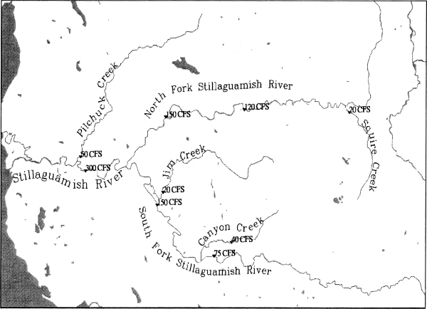
(2) Therefore, the department determines that the total consumptive withdrawals from existing and future water rights in the Stillaguamish River basin during open periods shall not exceed a total of 300 cubic feet per second (cfs) as measured at ecology station #05A070, river mile 11.2. Of that 300 cfs, the maximum allocation is further defined by limits on the amount of water that can be withdrawn from specified stream reaches, at specific times. Refer to the table and map, below.
Table 9
Maximum Allocation
| Water Source* | Open Period | |
| Stillaguamish River from its multiple mouths at Port Susan to the confluence of N.F. Stillaguamish River and S.F. Stillaguamish River (RM 0 to 17.8). | October 16-June 30 | |
| Maximum Allocation 300 cfs | ||
| Of that 300 cfs, the following maximums may be taken from the specified stream reaches at the specified times: | ||
| N.F. Stillaguamish, from RM 0 (its confluence with the S.F. Stillaguamish) to river mile 17.6. | October 16-June 30 | |
| Maximum Allocation 150 cfs | ||
| N.F. Stillaguamish River, from RM 17.6 to its headwaters. | November 1-June 30 | |
| Maximum Allocation 120 cfs | ||
| S.F. Stillaguamish River from its confluence with the N.F. Stillaguamish River (RM 17.9) to RM 34.9. | November 1-June 15 | |
| Maximum Allocation 150 cfs | ||
| Pilchuck Creek from mouth to RM 16.4 (confluence of Bear Creek). | October 16-May 31 | |
| Maximum Allocation 50 cfs | ||
| Squire Creek from mouth to its headwaters. | November 1-February 15, and May 1-June 30 | |
| Maximum Allocation 20 cfs | ||
| Canyon Creek from mouth to RM 11.8 (confluence of N.F. Canyon Creek and S.F. Canyon Creek). | December 1-May 31 | |
| Maximum Allocation 40 cfs | ||
| N.F. is North Fork | S.F. is South Fork | RM is river mile |
| * | Tributaries to the water sources are excluded from the open period unless specifically listed. |
Maximum allocations for specific stream reaches (listed above) in the Stillaguamish River basin, measured at designated control points
|
(4) The department will maintain a record of the amount of water allocated from all water rights in the Stillaguamish River basin, including those existing prior to the effective date of this chapter. When the maximum allocation is fully appropriated for any river, river reach, or stream, the department shall notify the appropriate county, in writing. The department shall also issue a public notice in a newspaper of general circulation for the region stating the maximum allocation is fully allocated.
[]
(a) The proposed use is nonconsumptive, and compatible with the intent of this chapter.
(b) The applicant elects to submit a scientifically sound mitigation plan, as defined in WAC 173-505-030(7), and it is approved by the department. If monitoring of a mitigation plan shows the mitigation is not effective, use of water under the permit shall then be subject to the instream flows. In the case of a closed stream, the use shall cease until a more effective mitigation plan is put in place.
(c) The proposed ground water use will not impair senior water rights. Based on the hydrogeology of the basin, and the location and depth where ground water withdrawals generally occur, future ground water withdrawals have a high likelihood of capturing water that would result in impacts to surface water flows and levels in the Stillaguamish River basin. Therefore, a ground water permit that is not subject to the instream flows or closures may be approved only if an applicant can demonstrate, through studies and technical analysis, and to the satisfaction of the department, that the proposed use will not cause impairment to existing water rights, including the instream flows set in this chapter.
(d) Before the department can approve a water right application for a new public water supply under (b) or (c) of this subsection, the applicant must also demonstrate that there are no other municipal water suppliers in the same proposed retail service area that can provide water. If domestic potable water can be provided by another municipal supplier, the department shall reject the water right application.
(e) The proposed use is for a salmon recovery project recommended for approval by the department of fish and wildlife.
(2) All water right permits approved by the department for a consumptive use from a water source with instream flows established by this chapter and during open periods are subject to those instream flows, as established in WAC 173-505-050. In addition, the total appropriation cannot exceed the maximum allocation limits described in WAC 173-505-100.
(3) No right to withdraw, divert or store the public surface or ground waters of the Stillaguamish River basin that conflicts with the provisions of this chapter will hereafter be granted, except in cases where such rights will clearly serve overriding considerations of the public interest, as stated in RCW 90.54.020 (3)(a).
(4) All future surface and ground water permit holders shall be required to install and maintain measuring devices, in accordance with specifications provided by the department, and report the data to the department in accordance with the permit requirements. In addition, the department may require the permit holder to monitor stream flows and ground water levels.
[]
• Reuse of reclaimed water;
• Artificial recharge and recovery;
• Multipurpose water storage facilities;
• Conservation and efficiency measures applied to existing uses and the transfer of saved water;
• Acquisition of existing water rights; and
• Establishment of a trust water rights program.
(2) Alternative sources of water of equal or better quality than a new source can be used to improve stream flows for fish, offset impacts of withdrawals on stream flows and provide sources of water for future out-of-stream uses.
[]
(2) The determination of how much water should be allocated between future out-of-stream uses and the restoration and enhancement of instream flows will be made at the time the water is acquired and deposited into the trust water rights program.
[]
[]
(2) When the department determines that a violation has occurred, it shall:
(a) First attempt to achieve voluntary compliance. An approach to achieving this is to offer information and technical assistance to the person, in writing, identifying one or more means to accomplish the person's purposes within the framework of the law.
(b) If education and technical assistance do not achieve compliance, the department shall issue a notice of violation, a formal administrative order under RCW 43.27A.190, or assess penalties under RCW 43.83B.336, 90.03.400, 90.03.410, 90.03.600, 90.44.120 and 90.44.130.
[]
[]
[]
 |
[]