PROPOSED RULES
Original Notice.
Preproposal statement of inquiry was filed as WSR 03-20-046.
Title of Rule and Other Identifying Information: Cultural resources protection and management in forest practices.
Hearing Location(s): Natural Resources Building, Room 172, 1111 Washington Street S.E., Olympia, WA 98504-7012, on Tuesday, January 11, 2005, at 3:00 p.m.
Date of Intended Adoption: February 9, 2005.
Submit Written Comments to: Patricia Anderson, Department of Natural Resources, Forest Practices Division, 1111 Washington Street S.E., P.O. Box 47012, Olympia, WA 98504-7012, e-mail forest.practicesboard@wadnr.gov, fax (360) 902-1428, by January 12, 2005.
Assistance for Persons with Disabilities: Contact Forest Practices Division at (360) 902-1400, by January 3, 2005, TTY (360) 902-1125.
Purpose of the Proposal and Its Anticipated Effects, Including Any Changes in Existing Rules: The purpose is to facilitate protection and management of cultural resources as they relate to forest practices. The proposals' anticipated effects would be voluntary and proactive development of landowner-tribal relationships and agreements for protections of cultural resources on a given landscape, to result in smoother and more predictable forest practices application processing for landowners and increased protection of cultural resources.
Proposed Changes to Existing Rules:
WAC 222-08-160(1) Continuing review of forest practices rules, include review of the Forests and Fish Report Addendum, "The Cultural Resources Protection and Management Plan," in the board's review of continuing forest practices processes.
WAC 222-12-010 Authority, include "foster cooperative relationships and agreements with affected tribes" as part of the Forest Practices Board's authority in promulgating orest practices rules.
WAC 222-12-046 (3) and (4) Cumulative effects, include the Office of Archaeology and Historic Preservation in the list of the Forest Practices Board's consultants, and make other minor clarifications.
WAC 222-12-090(11) Forest Practices Board manual, add a cultural resources module to Forest Practices Board manual #11.
WAC 222-16-010 Definitions, add a comma in the definition of "cultural resources" to clarify that archaeological and historic sites and artifacts are not limited to those of affected tribes.
WAC 222-22-010, 222-22-020, 222-22-045 (new), 222-22-050, 222-22-060, 222-22-070, 222-22-080 and 222-22-090, watershed analysis, add the concept behind, and the process requirements for, conducting the new cultural resources module in watershed analysis, and make minor grammatical clarifications to existing rule language.
Reasons Supporting Proposal: The rule proposal, along with the development of a cultural resources plan, fulfills commitments made in the 1999 Forests and Fish Report (Appendix G. (G.1) and Appendix O. (O.3).
Statutory Authority for Adoption: RCW 76.09.040, 76.09.370, and chapter 34.05 RCW.
Statute Being Implemented: Not applicable.
Rule is not necessitated by federal law, federal or state court decision.
Agency Comments or Recommendations, if any, as to Statutory Language, Implementation, Enforcement, and Fiscal Matters: The proposal adds a cultural resources module in the Forest Practices Board manual #11 so that when watershed analysis is undertaken in a watershed, an assessment of cultural resources will be accomplished along with other resource assessment, e.g., mass wasting, surface erosion, etc. Management strategies would be developed from the cultural resources assessment. Unlike prescriptions developed for the other watershed analysis assessments, implementation of the cultural resources management strategies by landowners would be voluntary.
Name of Proponent: Forest Practices Board, governmental.
Name of Agency Personnel Responsible for Drafting: Sherri Felix, 1111 Washington Street S.E., Olympia, (360) 902-1446; Implementation: Jed Herman, 1111 Washington Street S.E., Olympia, (360) 902-1684; and Enforcement: Lenny Young, 1111 Washington Street S.E., Olympia, (360) 902-1744.
A small business economic impact statement has been prepared under chapter 19.85 RCW.
In the adoption of a rule under chapter 34.05 RCW, an agency shall prepare a small business economic impact statement: (a) If the proposed rule will impose more than minor costs on businesses in an industry; or (b) if requested to do so by a majority vote of the joint administrative rules review committee within forty-five days of receiving the notice of proposed rule making under RCW 34.05.320.
Legislative direction for preparing an SBEIS may be found in the Regulatory Fairness Act (chapter 19.85 RCW). The legislative intent underlying the Regulatory Fairness Act is to reduce "the disproportionate impact of state administrative rules on small business..." A small business is defined as having fifty or fewer employees, and the SBEIS is intended to identify whether the impact of a proposed new rule falls disproportionately on small businesses and, if so, to identify ways to mitigate for it.
Another part of the rule-making procedure requires completion of a benefit-cost analysis (BCA) prior to rule adoption, in order to demonstrate that probable benefits of the proposed new rule exceed its probable costs and, further, to demonstrate that the proposed rule change is the most cost-effective means of achieving the goal of the rule change. Legislative direction for preparing a BCA may be found in the Administrative Procedure Act (chapter 34.05 RCW). The Administrative Procedure Act requires, under subsection (1) of RCW 34.05.328, that:
Before adopting a rule... an agency shall:...
(d) Determine that the probable benefits of the rule are greater than its probable costs, taking into account both the qualitative and quantitative benefits and costs and the specific directives of the statute being implemented;
(e) Determine, after considering alternative versions of the rule... that the rule being adopted is the least burdensome alternative for those required to comply with it...
The above determinations must be documented before final rule adoption and included in the rule-making record. This economic analysis combines the SBEIS and the BCA and complies with the legislative requirements for these economic analyses as part of the rule-making process.
Need for Proposal: Pursuant to RCW 76.09.370 the Forest Practices Board takes action on certain commitments made in the 1999 Forest and Fish Report. The report commitments included creation of a cultural resources assessment and protection module for watershed analysis (Forest Practices Board Manual, Section 11).
Watershed analysis is a process that was developed by forest landowners, Indian tribes, environmental groups and state natural resource agencies. It was adopted into regulation by the Forest Practices Board in 1992, and designed as a biological and physical assessment of a watershed conducted in order to address the cumulative effects of forest practices on specific public resources (fish, water, and capital improvements of the state). Assessment is accomplished by multidisciplinary teams that follow methodologies outlined in watershed analysis modules (i.e., modules that address mass wasting, surface erosion, hydrology, riparian, stream channel, and water supply/public works).
The proposal adds a cultural resources assessment and protection module to board manual Section 11. Forest practices rule revisions are necessary to integrate the new module into the manual. The module and rule proposal have been developed collaboratively through the Timber Fish and Wildlife (TFW) Cultural Resources Committee at the request of the Forest Practices Board.
Summary of Proposal Relevant to Economic Analysis1: WAC 222-12-090 Forest practices board manual, includes a cultural resource module within The Standard Methodology for Conducting Watershed Analysis (Section 11 of the Forest Practices Board Manual) that specifies the quantitative and qualitative methods, indices of resource conditions, and guidelines for developing voluntary management strategies for cultural resources.
WAC 222-22-010 Policy, states that the board intends that protection of cultural resources will be accomplished through voluntary management strategies, except protection of sites registered on the Office of Archaeology and Historic Preservation's archaeological and historic sites database, and all cultural resources that require protection under chapters 27.44 and 27.53 RCW would be mandatory. However, if voluntary approaches are shown to be ineffective, the board may find it appropriate to seek additional protection to prevent adverse impacts to cultural resources.
WAC 222-22-050 Level 1 watershed resource assessment and WAC 222-22-060 Level 2 watershed resource assessment, indicate that each assessment team shall include persons qualified in cultural anthropology and archaeology.
WAC 222-22-070 Prescriptions and management strategies, states that the field managers team shall include persons qualified in cultural anthropology and/or archaeology, and that for each identified cultural resources area of resource sensitivity the field managers team shall develop cultural resources management strategies in consultation with the assessment team and affected tribe(s).
Summary of Proposed Cultural Resources Module in Watershed Analysis: Under the proposal a detailed cultural resources module would provide a methodology for performing cultural resources assessment, either during a forest practices watershed analysis or as a stand-alone process. In the watershed analysis process, this module is an interdisciplinary team-based process for defining cultural resources sensitivities through assessment of existing and potential hazards and their effects on cultural resources vulnerabilities. Voluntary management strategies are then proposed and chosen, based on information generated in the resource assessment.
In watershed analysis, all cultural resources assessments follow a pattern similar to that of the other modules in the Standard Methodology for Conducting Watershed Analysis Board Manual. Cultural resources assessment involves the following steps and processes:
• Startup includes identifying and contacting stakeholders, choosing and training a research team, and developing a research plan.
• Cultural Resources Assessment includes researching published and archival materials and official records, interviewing resource people, producing inventory of cultural resources.
• Synthesis includes assessing the condition, sensitivity and vulnerability of the resources and developing problem statements.
• Management Strategies Process includes developing processes to minimize, prevent or avoid adverse impacts; proposing alternative management options; selecting voluntary management strategies in response to risk calls, and writing a field managers' report.
• Wrapup includes developing a monitoring module and writing a module report.
Economic Analysis: Economic analysis of the effects of the proposal focuses entirely on direct effects. Secondary and subsequent effects may be positive or negative and are highly speculative, and therefore have not been included in the analysis.
During the original rule-making process in 1992 for watershed analysis it was expected that costs to landowners would be highly uncertain, but expected to be extensive. The costs were anticipated to be related primarily to the cost of doing the watershed analysis, with possible revenue losses from deferred timber harvests and reduction in long-term productivity. Costs to landowners of the current proposal are expected to be of a similar nature.
Expected Cost of the Proposal:
Cost of Doing the Analysis: The proposed new rule (in WAC 222-22-050, 222-22-060, and 222-22-070) indicates that each assessment team shall include persons qualified in cultural anthropology and archaeology. Since these disciplines are specialized it is highly probable that a watershed assessment team will have to include an additional member or members with these qualifications. For the purpose of this economic analysis it is assumed that one additional team member will be required. Actual costs could be less than estimated here if multidisciplined persons can be found, or they could be more if a separate cultural anthropologist and an archaeologist are employed.
Level-1 watershed assessments and prescription development must be completed within forty-two days while level-2 watershed assessments and prescription developments must be completed within ninety days. For the purpose of this economic analysis it is assumed that the maximum allotted time period is used for the assessment. Further, it is assumed that one cultural resources specialist is employed for the maximum period for each level of assessment. Actual costs could be less if the assessment takes less than the maximum allotted time or if the specialist is employed less than full time during the assessment. The cost for the specialist is estimated at $201 per running day.2
Based on the above assumptions the additional cost for a level-1 assessment is $8,442 ($201 per day* forty-two days). For a level 2 assessment the estimated additional cost is $18,090 ($201 per day* ninety days).
Lost Sales or Revenue: As indicated above a second area of potential costs are revenue losses from deferred timber harvests and reduction in long-term productivity. State and federal laws already protect certain types of cultural resources from harm (National Historic Preservation Act and Washington Title 27 RCW) and restrict some management activities that could damage cultural resources.
The addition of a cultural resources module to the watershed analysis process will facilitate existing protection of cultural resources and not necessarily increase the level of protection provided under law. The team will identify cultural resources within the watershed and develop voluntary management strategies for protection and management of any identified cultural resources. Actual impact, above that already required by existing law, will depend on the agreed upon management strategies to protect the cultural resources within the subject watershed. Individual management strategies will be developed through consensus with the landowner and implementation above that required by existing law is voluntary for landowners.
For the purpose of this analysis it is assumed that overall sales and revenue impact if any, will be minimal because (1) the strategies will be developed through consensus with the landowner, (2) implementation is voluntary, and (3) there are existing laws to protect certain types of cultural resources.
Expected Benefit of Proposal: The primary benefit of the proposal would be to increase protection of the heritage and ongoing Native American and European-based cultures by identifying and protecting cultural resources that could otherwise be destroyed or degraded by normal forest practices activities. The rule change would improve implementation of the Forest Practices Act's policy to coordinate and cooperate with the tribes, and foster compliance with state and federal laws protecting cultural resources. It is anticipated that this interaction by landowners and tribes will facilitate smoother and more predictable forest practices application processing for landowners by proactive development of landowner-tribal relationships and advance agreement regarding protection of cultural resources on a given landscape.
The development of the cultural resources module and adoption of these rules would fulfill two commitments of the Forests and Fish Report: To create a cultural resources module and adopt rules to integrate the module.
Adoption and implementation of these cultural resources provisions will support the development of a habitat conservation plan based upon the Forests and Fish Report. In addition the module may be used independent of a full watershed analysis to protect cultural resources on forested or other lands by landowners.
Least Burdensome Alternative: Pursuant to RCW 76.09.370 the Forest Practices Board is developing these rules to fulfill commitments made in the 1999 Forests and Fish Report to create a cultural resources module for watershed analysis and support full implementation of existing forest practices cultural resources rules.
In keeping with this commitment, the module and these forest practices rules to define its use in a watershed analysis (conducted under chapter 222-22 WAC) were developed collaboratively through the TFW Cultural Resources Committee at the request of the Forest Practices Board. The proposed rules are necessary to integrate the new module into watershed analysis.
The watershed analysis cultural resources module and the proposed rules were arrived at through negotiation by stakeholders with representation of forest landowners who would be required to conduct the new module in any newly initiated watershed analysis for their lands. Further, those who choose to conduct a watershed analysis will be fully involved in the development of management strategies, and implementation of those strategies is voluntary for landowners.
The proposal is the least burdensome alternative that will achieve the general goals and specific objectives of the Forest Practices Board, forest landowners, and tribes to fulfill the commitments made in the 1999 Forests and Fish Report.
Small Business Economic Impact Statement: The legislative intent underlying the Regulatory Fairness Act is to reduce "the disproportionate impact of state administrative rules on small business." (RCW 19.85.011) The concern is that rules that require reporting or other fixed compliance costs will have a disproportionate impact on small firms. In this case the cost to the business is related to the land ownership, rather than the business size.
The law defines "small business" as one having less than fifty employees, but there is no readily available information on the ownership of forest lands potentially impacted by the presence of cultural resources by this definition. One useful designation for which information on ownership patterns is known is "small forest landowner." A forest landowner is considered a small forest landowner if the harvest from their land averages less than two million board feet per year.3 It is believed that there is a high correlation between small businesses and small forest landowners, although there are small businesses that own large acreages of forest land in Washington state.
Watershed analysis conducted pursuant to Forest Practices Board Manual Section 11 may only be initiated by the department or by a landowner or owners of 10% or more of the nonfederal forest land acreage in a watershed. Therefore, it follows that watershed analysis is more likely to be initiated and participated in by landowners that have a significant ownership within a watershed. Smaller landowners are expected to participate less often and therefore be less, not more impacted by this rule change. For this reason, the impact of this proposal on small businesses, which are also small forest landowners, is not likely to be disproportionately greater than that on businesses as a whole.
Results and Findings: The following conclusions can be drawn from the above analysis:
1. Small Businesses Impact: Small businesses are not expected to be disproportionately impacted as a result of the proposal than are businesses as a whole.
2. Benefits of Proposal: The primary benefit of the proposal is to increase the protection of the heritage and ongoing culture of both Native American and European-based cultures by identifying and protecting cultural resources that could otherwise be destroyed or degraded by normal forest practices activities. In addition, it is anticipated that this interaction by landowners and tribes will facilitate smoother and more predictable forest practices application processing for landowners.
3. Cost of Proposal: The estimated cost for a level-1 assessment is $8,442, and $18,090 for a level-2 assessment. There may be additional cost due to revenue losses from deferred timber harvests and reduction in long-term productivity. The level of these costs is expected to be minimal but cannot be determined at this time.
4. Comparison of Benefits and Cost of Proposal: While the probable benefits associated with the proposed new rules are not quantifiable, and therefore cannot be directly compared with the quantifiable cost of the proposal taking into account both the qualitative and quantitative benefits and costs, and the specific directives of the statute being implemented, based on the findings of this analysis it is reasonable to conclude that the probable benefits of the proposal are greater than its probable costs.
5. Least Burdensome Alternative: The objective of the proposal is to update the existing rules to incorporate the cultural resources module to fulfill the 1999 commitments made in the Forests and Fish Report. The cultural resource module of watershed analysis and the proposed rules were arrived at through negotiation with full representation of landowners. Further, landowners would be fully involved in the development of management strategies, and implementation of those strategies is voluntary for landowners.
Based on the analysis done in this report, it is reasonable to conclude that the proposal is the least burdensome alternative for those required to comply with it, and that will achieve the general goals and specific objectives set by the Forest Practices Board.
1 This summary is provided for the convenience of the reader and should not be relied upon as a complete list of all changes.
2 The running daily rate of $201 is approximated based on a monthly salary of $5,015 and benefits of 22% (salary and benefits of a Natural Resource Scientist 3 in state civil service). The running daily rate is based on continuous days, not working days, and is calculated as $5,015*12/365=$165. The benefits are 22% of salaries or $165*22%=$36. Total running daily rate is $165+$36=$201.
3 For a full definition of small forest landowner see definition of "forest landowner" in emergency RMAPs rules for chapter 222-16 WAC at www.dnr.wa.gov/forestpractices/rules.
A copy of the statement may be obtained by contacting Patricia Anderson, Department of Natural Resources, Forest Practices Division, 111 [1111] Washington Street S.E., P.O. Box 47012, Olympia, WA 98504-7012, phone (360) 902-1400, fax (360) 902-1428, e-mail forest.practicesboard@wadnr.gov.
A cost-benefit analysis is required under RCW 34.05.328. A preliminary cost-benefit analysis may be obtained by contacting Patricia Anderson, Department of Natural Resources, Forest Practices Division, 111 [1111] Washington Street S.E., P.O. Box 47012, Olympia, WA 98504-7012, phone (360) 902-1400, fax (360) 902-1428, e-mail forest.practicesboard@wadnr.gov.
November 10, 2004
Pat McElroy
Chair
OTS-7660.2
AMENDATORY SECTION(Amending WSR 01-12-042, filed 5/30/01,
effective 7/1/01)
WAC 222-08-160
Continuing review of forest practices
rules.
*(1) Annual evaluations. The department, after
consulting with affected state agencies, Indian tribes, forest
landowners, fish and wildlife, natural resources, and
environmental interest groups, shall ((beginning July 1,
1988,)) report annually to the forest practices board. This
reporting will be an assessment of how the rules and voluntary
processes, including the Cultural Resources Protection and
Management Plan, as committed in the 1999 Forests and Fish
Report, Appendix O (O.3), are working.
*(2) Adaptive management program. The adaptive management program will be used to determine the effectiveness of forest practices rules in aiding the state's salmon recovery effort and provide recommendations to the board on proposed changes to forest practices rules to meet timber industry viability and salmon recovery. The program provides assurances that rules and guidance not meeting aquatic resource objectives will be modified in a streamlined and timely manner. The board may also use this program to adjust other forest practice rules and guidance in order to further the purposes of chapter 76.09 RCW. The specific components of the adaptive management program are set forth in WAC 222-12-045.
(3) Resource management plans. The department is directed to develop a method for cooperative voluntary resource management planning among forest landowners, governmental agencies, affected Indian tribes, and environmental groups which would result in the development of plans which might be used as an alternative to the forest practice rules in achieving the purposes and policies set forth in the act. This should be done through pilot projects, at least one of which should be located on the east side of the Cascade summit and one on the west side of the Cascade summit.
(4) Compliance monitoring. The department shall conduct compliance monitoring that addresses the following key question: "Are forest practices being conducted in compliance with the rules?" The department shall provide statistically sound, biennial compliance audits and monitoring reports to the board for consideration and support of rule and guidance analysis. Compliance monitoring shall determine whether forest practices rules are being implemented on the ground. An infrastructure to support compliance will include adequate compliance monitoring, enforcement, training, education and budget.
[Statutory Authority: Chapter 34.05 RCW, RCW 76.09.040, [76.09.]050, [76.09.]370, 76.13.120(9). 01-12-042, recodified as § 222-08-160, filed 5/30/01, effective 7/1/01. Statutory Authority: RCW 76.09.040 and chapter 34.05 RCW. 97-24-091, § 222-08-035, filed 12/3/97, effective 1/3/98. Statutory Authority: RCW 76.09.040. 87-23-036 (Order 535), § 222-08-035, filed 11/16/87, effective 1/1/88.]
OTS-6583.2
AMENDATORY SECTION(Amending WSR 01-12-042, filed 5/30/01,
effective 7/1/01)
WAC 222-12-010
Authority.
These forest practices rules
are adopted pursuant to chapter 76.09 RCW, RCW 76.13.100
through 76.13.130, and RCW 77.85.180 through 77.85.190. Where
necessary to accomplish the purposes and policies stated in
the act, the board is authorized to promulgate forest
practices rules pursuant to chapter 34.05 RCW and in
accordance with the procedures enumerated in the act. These
rules establish minimum standards for forest practices,
provide procedures for the voluntary development of resource
management plans, set forth necessary administrative
provisions, establish procedures for the collection and
administration of forest practice fees, allow for the
development of watershed analyses, foster cooperative
relationships and agreements with affected tribes, and
establish the riparian open space program. The board also
establishes which forest practices will be included within
each class and is authorized to adopt rules under RCW 76.09.055, 76.09.370, and 76.13.120(9).
Promulgation of all forest practices rules shall be accomplished so that compliance with such forest practices rules will achieve compliance with the water quality laws.
Those rules marked with an asterisk (*) pertain to water quality protection; pursuant to RCW 76.09.040 they can be amended only by agreement between the board and the department of ecology.
Forest practices rules shall be administered and enforced by the department except as otherwise provided in the act. Such rules shall be administered so as to give consideration to all purposes and policies set forth in RCW 76.09.010.
[Statutory Authority: Chapter 34.05 RCW, RCW 76.09.040, [76.09.]050, [76.09.]370, 76.13.120(9). 01-12-042, § 222-12-010, filed 5/30/01, effective 7/1/01; Order 263, § 222-12-010, filed 6/16/76.]
(1) TITLE 222 WAC establishes minimum standards for all forest practices, regardless of the class of forest practice application.
(2) Forest practices which have a potential for a substantial impact on the environment are classified as Class IV-Special or Class IV-General by WAC 222-16-050 and receive an evaluation as to whether or not a detailed statement must be prepared pursuant to chapter 43.21C RCW.
(3) Certain rules are designed to focus on specific aspects of cumulative effects of forest practices. For example:
(a) WAC 222-08-035 requires continuing review of the forest practices rules and voluntary processes and adopts the concept of adaptive management. WAC 222-12-045 also adopts adaptive management.
(b) WAC 222-12-040 allows alternate plans that provide protection to public resources at least equal in overall effectiveness to the protection provided in the Forest Practices Act and rules.
(c) WAC 222-24-051 allows the department to require road maintenance and abandonment plans.
(d) WAC 222-30-025 addresses harvest unit size and separation requirements.
(e) Chapter 222-22 WAC addresses cumulative effects of forest practices on, at a minimum, the public resources of fish, water, and capital improvements of the state or its political subdivisions.
(f) Chapter 222-46 WAC establishes the enforcement policy for forest practices.
(4) The board shall continue consultation with the
departments of ecology, fish and wildlife, and natural
resources, the office of archaeology and historic
preservation, forest landowners, and ((federally recognized))
affected tribes to further protect cultural resources and
wildlife resource issues.
[Statutory Authority: Chapter 34.05 RCW, RCW 76.09.040, [76.09.]050, [76.09.]370, 76.13.120(9). 01-12-042, § 222-12-046, filed 5/30/01, effective 7/1/01. Statutory Authority: RCW 76.09.040 and chapter 34.05 RCW. 97-24-091, § 222-12-046, filed 12/3/97, effective 1/3/98. Statutory Authority: RCW 76.09.040, 76.09.050 and chapter 34.05 RCW. 92-15-011, § 222-12-046, filed 7/2/92, effective 8/2/92.]
(1) Method for determination of adequate shade requirements on streams needed for use with WAC 222-30-040.
(2) Standards for identifying channel migration zones and bankfull channel features.
(3) Guidelines for forest roads.
(4) Guidelines for clearing slash and debris from Type Np and Ns Waters.
(5) Guidelines for landing location and construction.
(6) Guidelines for determining acceptable stocking levels.
(7) Guidelines for riparian management zones.
(8) Guidelines for wetland delineation.
(9) Guidelines for wetland replacement or substitution.
(10) A list of nonnative wetland plant species.
(11) The standard methodology((, which)) for conducting
watershed analysis shall specify the quantitative methods,
indices of resource conditions, and definitions, for
conducting watershed analysis under chapter 222-22 WAC. The
methodology shall also include a cultural resource module that
shall specify the quantitative and qualitative methods,
indices of resource conditions, and guidelines for developing
voluntary management strategies for cultural resources.
Except for cultural resources, the department, in consultation
with Timber/Fish/Wildlife's Cooperative Monitoring, Evaluation
and Research Committee (CMER), may make minor modifications to
the version of the standard methodology approved by the board.
Substantial amendments to the standard methodology requires
approval by the board.
(12) Guidelines for forest chemicals.
(a) A list of special concerns related to aerial application of pesticides developed under WAC 222-16-070(3).
(b) Guidelines for aerial applications of pesticides and other forest chemicals under chapter 222-38 WAC.
(13) Guidelines for determining fish use for the purpose of typing waters under WAC 222-16-031.
(14) Survey protocol for marbled murrelets. The Pacific seabird survey protocol in effect March 1, 1997, shall be used when surveying for marbled murrelets in a stand. Surveys conducted before the effective date of this rule are valid if they were conducted in substantial compliance with generally accepted survey protocols in effect at the beginning of the season in which they were conducted.
(15) The department shall, in consultation with the department of fish and wildlife, develop platform protocols for use by applicants in estimating the number of platforms, and by the department in reviewing and classifying forest practices under WAC 222-16-050. These protocols shall include:
(a) A sampling method to determine platforms per acre in the field;
(b) A method to predict the number of platforms per acre based on information measurable from typical forest inventories. The method shall be derived from regression models or other accepted statistical methodology, and incorporate the best available data; and
(c) Other methods determined to be reliable by the department, in consultation with the department of fish and wildlife.
(16) Guidelines for evaluating potentially unstable slopes and landforms.
(17) Guidelines for the small forest landowner forestry riparian easement program.
(18) Guidelines for riparian open space program.
(19) Guidelines for hardwood conversion.
(20) Guidelines for financial assurances.
(21) Guidelines for alternate plans.
(22) Guidelines for adaptive management program.
(23) Guidelines for field protocol to locate mapped divisions between stream types and perennial stream identification.
(24) Guidelines for interim modification of bull trout habitat overlay.
(25) Guidelines for bull trout presence survey protocol.
(26) Guidelines for placement strategy for woody debris in streams.
[Statutory Authority: Chapter 34.05 RCW, RCW 76.09.040, [76.09.]050, [76.09.]370, 76.13.120(9). 01-12-042, § 222-12-090, filed 5/30/01, effective 7/1/01. Statutory Authority: RCW 76.09.040 and chapter 34.05 RCW. 97-24-091, § 222-12-090, filed 12/3/97, effective 1/3/98; 97-15-105, § 222-12-090, filed 7/21/97, effective 8/21/97. Statutory Authority: RCW 76.09.040, 76.09.050 and chapter 34.05 RCW. 92-15-113, § 222-12-090, filed 7/21/92, effective 8/21/92. Statutory Authority: RCW 76.09.040. 88-19-112 (Order 551, Resolution No. 88-1), § 222-12-090, filed 9/21/88, effective 11/1/88; 87-23-036 (Order 535), § 222-12-090, filed 11/16/87, effective 1/1/88. Statutory Authority: RCW 76.09.040 and 76.09.050. 82-16-077 (Resolution No. 82-1), § 222-12-090, filed 8/3/82, effective 10/1/82; Order 263, § 222-12-090, filed 6/16/76.]
Reviser's note: The bracketed material preceding the section above was supplied by the code reviser's office.
Reviser's note: RCW 34.05.395 requires the use of underlining and deletion marks to indicate amendments to existing rules. The rule published above varies from its predecessor in certain respects not indicated by the use of these markings.
OTS-7659.1
AMENDATORY SECTION(Amending WSR 04-05-087, filed 2/17/04,
effective 3/19/04)
WAC 222-16-010
General definitions.*
Unless otherwise
required by context, as used in these rules:
"Act" means the Forest Practices Act, chapter 76.09 RCW.
"Affected Indian tribe" means any federally recognized Indian tribe that requests in writing from the department information on forest practices applications and notification filed on specified areas.
"Alluvial fan" see "sensitive sites" definition.
"Appeals board" means the forest practices appeals board established in the act.
"Aquatic resources" means water quality, fish, the Columbia torrent salamander (Rhyacotriton kezeri), the Cascade torrent salamander (Rhyacotriton cascadae), the Olympic torrent salamander (Rhyacotriton olympian), the Dunn's salamander (Plethodon dunni), the Van Dyke's salamander (Plethodon vandyke), the Tailed frog (Ascaphus truei) and their respective habitats.
"Area of resource sensitivity" means areas identified in accordance with WAC 222-22-050 (2)(d) or 222-22-060(2).
"Bankfull depth" means the average vertical distance between the channel bed and the estimated water surface elevation required to completely fill the channel to a point above which water would enter the floodplain or intersect a terrace or hillslope. In cases where multiple channels exist, the bankfull depth is the average depth of all channels along the cross-section. (See board manual section 2.)
"Bankfull width" means:
(a) For streams - the measurement of the lateral extent of the water surface elevation perpendicular to the channel at bankfull depth. In cases where multiple channels exist, bankfull width is the sum of the individual channel widths along the cross-section (see board manual section 2).
(b) For lakes, ponds, and impoundments - line of mean high water.
(c) For tidal water - line of mean high tide.
(d) For periodically inundated areas of associated wetlands - line of periodic inundation, which will be found by examining the edge of inundation to ascertain where the presence and action of waters are so common and usual, and so long continued in all ordinary years, as to mark upon the soil a character distinct from that of the abutting upland.
"Basal area" means the area in square feet of the cross section of a tree bole measured at 4 1/2 feet above the ground.
"Bedrock hollows" (colluvium-filled bedrock hollows, or hollows; also referred to as zero-order basins, swales, or bedrock depressions) means landforms that are commonly spoon-shaped areas of convergent topography within unchannelled valleys on hillslopes. (See board manual section 16 for identification criteria.)
"Board" means the forest practices board established by the act.
"Bog" means wetlands which have the following characteristics: Hydric organic soils (peat and/or muck) typically 16 inches or more in depth (except over bedrock or hardpan); and vegetation such as sphagnum moss, labrador tea, bog laurel, bog rosemary, sundews, and sedges; bogs may have an overstory of spruce, western Hemlock, lodgepole pine, cedar, whitepine, crabapple, or aspen, and may be associated with open water. This includes nutrient-poor fens. (See board manual section 8.)
"Borrow pit" shall mean an excavation site outside the limits of construction to provide material necessary to that construction, such as fill material for the embankments.
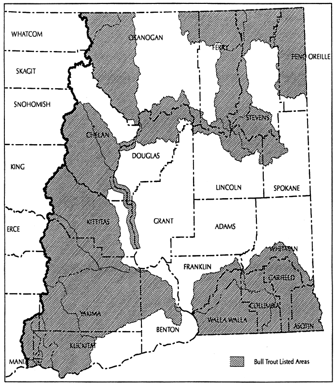
"Bull trout habitat overlay" means those portions of Eastern Washington streams containing bull trout habitat as identified on the department of fish and wildlife's bull trout map. Prior to the development of a bull trout field protocol and the habitat-based predictive model, the "bull trout habitat overlay" map may be modified to allow for locally-based corrections using current data, field knowledge, and best professional judgment. A landowner may meet with the departments of natural resources, fish and wildlife and, in consultation with affected tribes and federal biologists, determine whether certain stream reaches have habitat conditions that are unsuitable for supporting bull trout. If such a determination is mutually agreed upon, documentation submitted to the department will result in the applicable stream reaches no longer being included within the definition of bull trout habitat overlay. Conversely, if suitable bull trout habitat is discovered outside the current mapped range, those waters will be included within the definition of "bull trout habitat overlay" by a similar process.
|
"Chemicals" means substances applied to forest lands or timber including pesticides, fertilizers, and other forest chemicals.
"Clearcut" means a harvest method in which the entire stand of trees is removed in one timber harvesting operation. Except as provided in WAC 222-30-110, an area remains clearcut until:
It meets the minimum stocking requirements under WAC 222-34-010(2) or 222-34-020(2); and
The largest trees qualifying for the minimum stocking levels have survived on the area for five growing seasons or, if not, they have reached an average height of four feet.
"Columbia River Gorge National Scenic Area or CRGNSA" means the area established pursuant to the Columbia River Gorge National Scenic Area Act, 16 U.S.C. § 544b(a).
"CRGNSA special management area" means the areas designated in the Columbia River Gorge National Scenic Area Act, 16 U.S.C. § 544b(b) or revised pursuant to 16 U.S.C. § 544b(c). For purposes of this rule, the special management area shall not include any parcels excluded by 16 U.S.C. § 544f(o).
"CRGNSA special management area guidelines" means the guidelines and land use designations for forest practices developed pursuant to 16 U.S.C. § 544f contained in the CRGNSA management plan developed pursuant to 15 U.S.C. § 544d.
"Commercial tree species" means any species which is capable of producing a merchantable stand of timber on the particular site, or which is being grown as part of a Christmas tree or ornamental tree-growing operation.
"Completion of harvest" means the latest of:
Completion of removal of timber from the portions of forest lands harvested in the smallest logical unit that will not be disturbed by continued logging or an approved slash disposal plan for adjacent areas; or
Scheduled completion of any slash disposal operations where the department and the applicant agree within 6 months of completion of yarding that slash disposal is necessary or desirable to facilitate reforestation and agree to a time schedule for such slash disposal; or
Scheduled completion of any site preparation or rehabilitation of adjoining lands approved at the time of approval of the application or receipt of a notification: Provided, That delay of reforestation under this paragraph is permitted only to the extent reforestation would prevent or unreasonably hinder such site preparation or rehabilitation of adjoining lands.
"Constructed wetlands" means those wetlands voluntarily developed by the landowner. Constructed wetlands do not include wetlands created, restored, or enhanced as part of a mitigation procedure or wetlands inadvertently created as a result of current or past practices including, but not limited to: Road construction, landing construction, railroad construction, or surface mining.
"Contamination" means introducing into the atmosphere, soil, or water, sufficient quantities of substances as may be injurious to public health, safety or welfare, or to domestic, commercial, industrial, agriculture or recreational uses, or to livestock, wildlife, fish or other aquatic life.
"Convergent headwalls" (or headwalls) means teardrop-shaped landforms, broad at the ridgetop and terminating where headwaters converge into a single channel; they are broadly concave both longitudinally and across the slope, but may contain sharp ridges separating the headwater channels. (See board manual section 16 for identification criteria.)
"Conversion option harvest plan" means a voluntary plan developed by the landowner and approved by the local government entity indicating the limits of harvest areas, road locations, and open space.
"Conversion to a use other than commercial timber operation" shall mean a bona fide conversion to an active use which is incompatible with timber growing.
"Cooperative habitat enhancement agreement (CHEA)" see WAC 222-16-105.
"Critical habitat (federal)" means the habitat of any threatened or endangered species designated as critical habitat by the United States Secretary of the Interior or Commerce under Sections 3 (5)(A) and 4 (a)(3) of the Federal Endangered Species Act.
"Critical nesting season" means for marbled murrelets - April 1 to August 31.
"Critical habitat (state)" means those habitats designated by the board in accordance with WAC 222-16-080.
"Cultural resources" means archaeological and historic sites and artifacts, and traditional religious, ceremonial and social uses and activities of affected Indian tribes.
"Cumulative effects" means the changes to the environment caused by the interaction of natural ecosystem processes with the effects of two or more forest practices.
"Daily peak activity" means for marbled murrelets - one hour before official sunrise to two hours after official sunrise and one hour before official sunset to one hour after official sunset.
"Debris" means woody vegetative residue less than 3 cubic feet in size resulting from forest practice activities which would reasonably be expected to cause significant damage to a public resource.
"Deep-seated landslides" means landslides in which most of the area of the slide plane or zone lies below the maximum rooting depth of forest trees, to depths of tens to hundreds of feet. (See board manual section 16 for identification criteria.)
"Demographic support" means providing sufficient suitable spotted owl habitat within the SOSEA to maintain the viability of northern spotted owl sites identified as necessary to meet the SOSEA goals.
"Department" means the department of natural resources.
"Desired future condition (DFC)" is a reference point on a pathway and not an endpoint for stands. DFC means the stand conditions of a mature riparian forest at 140 years of age, the midpoint between 80 and 200 years. Where basal area is the only stand attribute used to describe 140-year old stands, these are referred to as the "Target Basal Area."
"Diameter at breast height (dbh)" means the diameter of a tree at 4 1/2 feet above the ground measured from the uphill side.
"Dispersal habitat" see WAC 222-16-085(2).
"Dispersal support" means providing sufficient dispersal habitat for the interchange of northern spotted owls within or across the SOSEA, as necessary to meet SOSEA goals. Dispersal support is provided by a landscape consisting of stands of dispersal habitat interspersed with areas of higher quality habitat, such as suitable spotted owl habitat found within RMZs, WMZs or other required and voluntary leave areas.
"Drainage structure" means a construction technique or feature that is built to relieve surface runoff and/or intercepted ground water from roadside ditches to prevent excessive buildup in water volume and velocity. A drainage structure is not intended to carry any typed water. Drainage structures include structures such as: Cross drains, relief culverts, ditch diversions, water bars, or other such structures demonstrated to be equally effective.
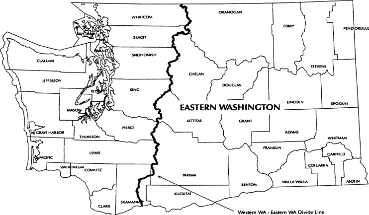
"Eastern Washington" means the geographic area in Washington east of the crest of the Cascade Mountains from the international border to the top of Mt. Adams, then east of the ridge line dividing the White Salmon River drainage from the Lewis River drainage and east of the ridge line dividing the Little White Salmon River drainage from the Wind River drainage to the Washington-Oregon state line.
 |
"Eastern Washington timber habitat types" means elevation ranges associated with tree species assigned for the purpose of riparian management according to the following:
| Timber Habitat Types | Elevation Ranges |
| ponderosa pine | 0 - 2500 feet |
| mixed conifer | 2501 - 5000 feet |
| high elevation | above 5000 feet |
"End hauling" means the removal and transportation of excavated material, pit or quarry overburden, or landing or road cut material from the excavation site to a deposit site not adjacent to the point of removal.
"Equipment limitation zone" means a 30-foot wide zone measured horizontally from the outer edge of the bankfull width of a Type Np or Ns Water. It applies to all perennial and seasonal nonfish bearing streams.
"Erodible soils" means those soils that, when exposed or displaced by a forest practice operation, would be readily moved by water.
"Even-aged harvest methods" means the following harvest methods:
Clearcuts;
Seed tree harvests in which twenty or fewer trees per acre remain after harvest;
Shelterwood regeneration harvests in which twenty or fewer trees per acre remain after harvest;
Group or strip shelterwood harvests creating openings wider than two tree heights, based on dominant trees;
Shelterwood removal harvests which leave fewer than one hundred fifty trees per acre which are at least five years old or four feet in average height;
Partial cutting in which fewer than fifty trees per acre remain after harvest;
Overstory removal when more than five thousand board feet per acre is removed and fewer than fifty trees per acre at least ten feet in height remain after harvest; and
Other harvesting methods designed to manage for multiple age classes in which six or fewer trees per acre remain after harvest.
Except as provided above for shelterwood removal harvests and overstory removal, trees counted as remaining after harvest shall be at least ten inches in diameter at breast height and have at least the top one-third of the stem supporting green, live crowns. Except as provided in WAC 222-30-110, an area remains harvested by even-aged methods until it meets the minimum stocking requirements under WAC 222-34-010(2) or 222-34-020(2) and the largest trees qualifying for the minimum stocking levels have survived on the area for five growing seasons or, if not, they have reached an average height of four feet.
"Fen" means wetlands which have the following characteristics: Peat soils 16 inches or more in depth (except over bedrock); and vegetation such as certain sedges, hardstem bulrush and cattails; fens may have an overstory of spruce and may be associated with open water.
"Fertilizers" means any substance or any combination or mixture of substances used principally as a source of plant food or soil amendment.
"Fill" means the placement of earth material or aggregate for road or landing construction or other similar activities.
"Fish" means for purposes of these rules, species of the vertebrate taxonomic groups of Cephalospidomorphi and Osteichthyes.
"Fish habitat" means habitat, which is used by fish at any life stage at any time of the year including potential habitat likely to be used by fish, which could be recovered by restoration or management and includes off-channel habitat.
"Flood level - 100 year." Is a calculated flood event flow based on an engineering computation of flood magnitude that has a 1 percent chance of occurring in any given year. For purposes of field interpretation, landowners may use the following methods:
Flow information from gauging stations;
Field estimate of water level based on guidance for "Determining the 100-Year Flood Level" in the forest practices board manual section 2.
The 100-year flood level shall not include those lands that can reasonably be expected to be protected from flood waters by flood control devices maintained by or under license from the federal government, the state, or a political subdivision of the state.
"Forest land" means all land which is capable of supporting a merchantable stand of timber and is not being actively used for a use which is incompatible with timber growing.
"Forest land owner" shall mean any person in actual control of forest land, whether such control is based either on legal or equitable title, or on any other interest entitling the holder to sell or otherwise dispose of any or all of the timber on such land in any manner: Provided, That any lessee or other person in possession of forest land without legal or equitable title to such land shall be excluded from the definition of "forest land owner" unless such lessee or other person has the right to sell or otherwise dispose of any or all of the timber located on such forest land.
"Forest practice" means any activity conducted on or directly pertaining to forest land and relating to growing, harvesting, or processing timber, including but not limited to:
Road and trail construction;
Harvesting, final and intermediate;
Precommercial thinning;
Reforestation;
Fertilization;
Prevention and suppression of diseases and insects;
Salvage of trees; and
Brush control.
"Forest practice" shall not include: Forest species seed orchard operations and intensive forest nursery operations; or preparatory work such as tree marking, surveying and road flagging; or removal or harvest of incidental vegetation from forest lands such as berries, ferns, greenery, mistletoe, herbs, mushrooms, and other products which cannot normally be expected to result in damage to forest soils, timber or public resources.
"Forest road" means ways, lanes, roads, or driveways on forest land used since 1974 for forest practices or forest management activities such as fire control. "Forest roads" does not include skid trails, highways, or county roads except where the county is a forest landowner or operator.
"Forest trees" excludes trees cultivated by agricultural methods in growing cycles shorter than ten years: Provided, That Christmas trees are forest trees and: Provided further, That this exclusion applies only to trees planted on land that was not in forest use immediately before the trees were planted and before the land was prepared for planting the trees.
"Full bench road" means a road constructed on a side hill without using any of the material removed from the hillside as a part of the road. This construction technique is usually used on steep or unstable slopes.
"Green recruitment trees" means those trees left after harvest for the purpose of becoming future wildlife reserve trees under WAC 222-30-020(11).
"Ground water recharge areas for glacial deep-seated slides" means the area upgradient that can contribute water to the landslide, assuming that there is an impermeable perching layer in or under a deep-seated landslide in glacial deposits. (See board manual section 16 for identification criteria.)
"Headwater spring" means a permanent spring at the head of a perennial channel. Where a headwater spring can be found, it will coincide with the uppermost extent of Type Np Water.
"Herbicide" means any substance or mixture of substances intended to prevent, destroy, repel, or mitigate any tree, bush, weed or algae and other aquatic weeds.
"Historic site" includes:
Sites, areas and structures or other evidence of human activities illustrative of the origins, evolution and development of the nation, state or locality; or
Places associated with a personality important in history; or
Places where significant historical events are known to have occurred even though no physical evidence of the event remains.
"Horizontal distance" means the distance between two points measured at a 0% slope.
"Hyporheic" means an area adjacent to and below channels where interstitial water is exchanged with channel water and water movement is mainly in the downstream direction.
"Identified watershed processes" means the following components of natural ecological processes that may in some instances be altered by forest practices in a watershed:
Mass wasting;
Surface and road erosion;
Seasonal flows including hydrologic peak and low flows and annual yields (volume and timing);
Large organic debris;
Shading; and
Stream bank and bed stability.
"Inner gorges" means canyons created by a combination of the downcutting action of a stream and mass movement on the slope walls; they commonly show evidence of recent movement, such as obvious landslides, vertical tracks of disturbance vegetation, or areas that are concave in contour and/or profile. (See board manual section 16 for identification criteria.)
"Insecticide" means any substance or mixture of substances intended to prevent, destroy, repel, or mitigate any insect, other arthropods or mollusk pests.
"Interdisciplinary team" (ID Team) means a group of varying size comprised of individuals having specialized expertise, assembled by the department to respond to technical questions associated with a proposed forest practice activity.
"Islands" means any island surrounded by salt water in Kitsap, Mason, Jefferson, Pierce, King, Snohomish, Skagit, Whatcom, Island, or San Juan counties.
"Limits of construction" means the area occupied by the completed roadway or landing, including the cut bank, fill slope, and the area cleared for the purpose of constructing the roadway or landing.
"Load bearing portion" means that part of the road, landing, etc., which is supportive soil, earth, rock or other material directly below the working surface and only the associated earth structure necessary for support.
"Local government entity" means the governments of counties and the governments of cities and towns as defined in chapter 35.01 RCW.
"Low impact harvest" means use of any logging equipment, methods, or systems that minimize compaction or disturbance of soils and vegetation during the yarding process. The department shall determine such equipment, methods or systems in consultation with the department of ecology.
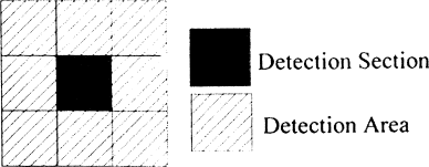
"Marbled murrelet detection area" means an area of land associated with a visual or audible detection of a marbled murrelet, made by a qualified surveyor which is documented and recorded in the department of fish and wildlife data base. The marbled murrelet detection area shall be comprised of the section of land in which the marbled murrelet detection was made and the eight sections of land immediately adjacent to that section.
 |
"Marbled murrelet nesting platform" means any horizontal tree structure such as a limb, an area where a limb branches, a surface created by multiple leaders, a deformity, or a debris/moss platform or stick nest equal to or greater than 7 inches in diameter including associated moss if present, that is 50 feet or more above the ground in trees 32 inches dbh and greater (generally over 90 years of age) and is capable of supporting nesting by marbled murrelets.
"Median home range circle" means a circle, with a specified radius, centered on a spotted owl site center. The radius for the median home range circle in the Hoh-Clearwater/Coastal Link SOSEA is 2.7 miles; for all other SOSEAs the radius is 1.8 miles.
"Merchantable stand of timber" means a stand of trees that will yield logs and/or fiber:
Suitable in size and quality for the production of lumber, plywood, pulp or other forest products;
Of sufficient value at least to cover all the costs of harvest and transportation to available markets.
"Multiyear permit" means a permit to conduct forest practices which is effective for longer than two years but no longer than five years.
"Northern spotted owl site center" means the location of status 1, 2 or 3 northern spotted owls based on the following definitions:
| Status 1: | Pair or reproductive - a male and female heard and/or observed in close proximity to each other on the same visit, a female detected on a nest, or one or both adults observed with young. |
| Status 2: | Two birds, pair status unknown - the presence or response of two birds of opposite sex where pair status cannot be determined and where at least one member meets the resident territorial single requirements. |
| Status 3: | Resident territorial single - the presence or response of a single owl within the same general area on three or more occasions within a breeding season with no response by an owl of the opposite sex after a complete survey; or three or more responses over several years (i.e., two responses in year one and one response in year two, for the same general area). |
"Notice to comply" means a notice issued by the department pursuant to RCW 76.09.090 of the act and may require initiation and/or completion of action necessary to prevent, correct and/or compensate for material damage to public resources which resulted from forest practices.
"Occupied marbled murrelet site" means:
(1) A contiguous area of suitable marbled murrelet habitat where at least one of the following marbled murrelet behaviors or conditions occur:
(a) A nest is located; or
(b) Downy chicks or eggs or egg shells are found; or
(c) Marbled murrelets are detected flying below, through, into or out of the forest canopy; or
(d) Birds calling from a stationary location within the area; or
(e) Birds circling above a timber stand within one tree height of the top of the canopy; or
(2) A contiguous forested area, which does not meet the definition of suitable marbled murrelet habitat, in which any of the behaviors or conditions listed above has been documented by the department of fish and wildlife and which is distinguishable from the adjacent forest based on vegetative characteristics important to nesting marbled murrelets.
(3) For sites defined in (1) and (2) above, the sites will be presumed to be occupied based upon observation of circling described in (1)(e), unless a two-year survey following the 2003 Pacific Seabird Group (PSG) protocol has been completed and an additional third-year of survey following a method listed below is completed and none of the behaviors or conditions listed in (1)(a) through (d) of this definition are observed. The landowner may choose one of the following methods for the third-year survey:
(a) Conduct a third-year survey with a minimum of nine visits conducted in compliance with 2003 PSG protocol. If one or more marbled murrelets are detected during any of these nine visits, three additional visits conducted in compliance with the protocol of the first nine visits shall be added to the third-year survey. Department of fish and wildlife shall be consulted prior to initiating third-year surveys; or
(b) Conduct a third-year survey designed in consultation with the department of fish and wildlife to meet site specific conditions.
(4) For sites defined in (1) above, the outer perimeter of the occupied site shall be presumed to be the closer, measured from the point where the observed behaviors or conditions listed in (1) above occurred, of the following:
(a) 1.5 miles from the point where the observed behaviors or conditions listed in (1) above occurred; or
(b) The beginning of any gap greater than 300 feet wide lacking one or more of the vegetative characteristics listed under "suitable marbled murrelet habitat"; or
(c) The beginning of any narrow area of "suitable marbled murrelet habitat" less than 300 feet in width and more than 300 feet in length.
(5) For sites defined under (2) above, the outer perimeter of the occupied site shall be presumed to be the closer, measured from the point where the observed behaviors or conditions listed in (1) above occurred, of the following:
(a) 1.5 miles from the point where the observed behaviors or conditions listed in (1) above occurred; or
(b) The beginning of any gap greater than 300 feet wide lacking one or more of the distinguishing vegetative characteristics important to murrelets; or
(c) The beginning of any narrow area of suitable marbled murrelet habitat, comparable to the area where the observed behaviors or conditions listed in (1) above occurred, less than 300 feet in width and more than 300 feet in length.
(6) In determining the existence, location and status of occupied marbled murrelet sites, the department shall consult with the department of fish and wildlife and use only those sites documented in substantial compliance with guidelines or protocols and quality control methods established by and available from the department of fish and wildlife.
"Old forest habitat" see WAC 222-16-085 (1)(a).
"Operator" shall mean any person engaging in forest practices except an employee with wages as his/her sole compensation.
"Ordinary high-water mark" means the mark on the shores of all waters, which will be found by examining the beds and banks and ascertaining where the presence and action of waters are so common and usual, and so long continued in all ordinary years, as to mark upon the soil a character distinct from that of the abutting upland, in respect to vegetation: Provided, That in any area where the ordinary high-water mark cannot be found, the ordinary high-water mark adjoining saltwater shall be the line of mean high tide and the ordinary high-water mark adjoining freshwater shall be the line of mean high-water.
"Other forest chemicals" means fire retardants when used to control burning (other than water), nontoxic repellents, oil, dust-control agents (other than water), salt, and other chemicals used in forest management, except pesticides and fertilizers, that may present hazards to the environment.
"Park" means any park included on the parks register maintained by the department pursuant to WAC 222-20-100(2). Developed park recreation area means any park area developed for high density outdoor recreation use.
"Partial cutting" means the removal of a portion of the merchantable volume in a stand of timber so as to leave an uneven-aged stand of well-distributed residual, healthy trees that will reasonably utilize the productivity of the soil. Partial cutting does not include seedtree or shelterwood or other types of regeneration cutting.
"Pesticide" means any insecticide, herbicide, fungicide, or rodenticide, but does not include nontoxic repellents or other forest chemicals.
"Plantable area" is an area capable of supporting a commercial stand of timber excluding lands devoted to permanent roads, utility rights-of-way, that portion of riparian management zones where scarification is not permitted, and any other area devoted to a use incompatible with commercial timber growing.
"Power equipment" means all machinery operated with fuel burning or electrical motors, including heavy machinery, chain saws, portable generators, pumps, and powered backpack devices.
"Preferred tree species" means the following species listed in descending order of priority for each timber habitat type:
| Ponderosa pine habitat type |
Mixed conifer habitat type |
|
| all hardwoods | all hardwoods | |
| ponderosa pine | western larch | |
| western larch | ponderosa pine | |
| Douglas-fir | western red cedar | |
| western red cedar | white pine | |
| Douglas-fir | ||
| lodgepole pine |
"Qualified surveyor" means an individual who has successfully completed the marbled murrelet field training course offered by the department of fish and wildlife or its equivalent.
"Rehabilitation" means the act of renewing, or making usable and reforesting forest land which was poorly stocked or previously nonstocked with commercial species.
"Resource characteristics" means the following specific measurable characteristics of fish, water, and capital improvements of the state or its political subdivisions:
For fish and water:
Physical fish habitat, including temperature and turbidity;
Turbidity in hatchery water supplies; and
Turbidity and volume for areas of water supply.
For capital improvements of the state or its political subdivisions:
Physical or structural integrity.
If the methodology is developed and added to the manual to analyze the cumulative effects of forest practices on other characteristics of fish, water, and capital improvements of the state or its subdivisions, the board shall amend this list to include these characteristics.
"Riparian function" includes bank stability, the recruitment of woody debris, leaf litter fall, nutrients, sediment filtering, shade, and other riparian features that are important to both riparian forest and aquatic system conditions.
"Riparian management zone (RMZ)" means:
(1) For Western Washington
(a) The area protected on each side of a Type S or F Water measured horizontally from the outer edge of the bankfull width or the outer edge of the CMZ, whichever is greater (see table below); and
| Site Class | Western Washington Total RMZ Width |
| I | 200' |
| II | 170' |
| III | 140' |
| IV | 110' |
| V | 90' |
(2) For Eastern Washington
(a) The area protected on each side of a Type S or F Water measured horizontally from the outer edge of the bankfull width or the outer edge of the CMZ, whichever is greater (see table below); and
| Site Class | Eastern Washington Total RMZ Width |
| I | 130' |
| II | 110' |
| III | 90' or 100'* |
| IV | 75' or 100'* |
| V | 75' or 100'* |
| * | Dependent upon stream size. (See WAC 222-30-022.) |
(3) For exempt 20 acre parcels, a specified area alongside Type S and F Waters where specific measures are taken to protect water quality and fish and wildlife habitat.
"RMZ core zone" means:
(1) For Western Washington, the 50 foot buffer of a Type S or F Water, measured horizontally from the outer edge of the bankfull width or the outer edge of the channel migration zone, whichever is greater. (See WAC 222-30-021.)
(2) For Eastern Washington, the 30 foot buffer of a Type S or F Water, measured horizontally from the outer edge of the bankfull width or the outer edge of the channel migration zone, whichever is greater. (See WAC 222-30-022.)
"RMZ inner zone" means:
(1) For Western Washington, the area measured horizontally from the outer boundary of the core zone of a Type S or F Water to the outer limit of the inner zone. The outer limit of the inner zone is determined based on the width of the affected water, site class and the management option chosen for timber harvest within the inner zone. (See WAC 222-30-021.)
(2) For Eastern Washington, the area measured horizontally from the outer boundary of the core zone 45 feet (for streams less than 15 feet wide) or 70 feet (for streams more than 15 feet wide) from the outer boundary of the core zone. (See WAC 222-30-022.)
"RMZ outer zone" means the area measured horizontally between the outer boundary of the inner zone and the RMZ width as specified in the riparian management zone definition above. RMZ width is measured from the outer edge of the bankfull width or the outer edge of the channel migration zone, whichever is greater. (See WAC 222-30-021 and 222-30-022.)
"Road construction" means the establishment of any new sub -grade including widening, realignment, or modification of an existing road prism, with the exception of replacing or installing drainage structures, for the purposes of managing forest land under TITLE 222 WAC.
"Road maintenance" means any road work specifically related to maintaining water control or road safety and visibility (such as; grading, spot rocking, resurfacing, roadside vegetation control, water barring, ditch clean out, replacing or installing relief culverts, cleaning culvert inlets and outlets) on existing forest roads.
"Rodenticide" means any substance or mixture of substances intended to prevent, destroy, repel, or mitigate rodents or any other vertebrate animal which the director of the state department of agriculture may declare by regulation to be a pest.
"Salvage" means the removal of snags, down logs, windthrow, or dead and dying material.
"Scarification" means loosening the topsoil and/or disrupting the forest floor in preparation for regeneration.
"Sensitive sites" are areas near or adjacent to Type Np Water and have one or more of the following:
(1) Headwall seep is a seep located at the toe of a cliff or other steep topographical feature and at the head of a Type Np Water which connects to the stream channel network via overland flow, and is characterized by loose substrate and/or fractured bedrock with perennial water at or near the surface throughout the year.
(2) Side-slope seep is a seep within 100 feet of a Type Np Water located on side-slopes which are greater than 20 percent, connected to the stream channel network via overland flow, and characterized by loose substrate and fractured bedrock, excluding muck with perennial water at or near the surface throughout the year. Water delivery to the Type Np channel is visible by someone standing in or near the stream.
(3) Type Np intersection is the intersection of two or more Type Np Waters.
(4) Headwater spring means a permanent spring at the head of a perennial channel. Where a headwater spring can be found, it will coincide with the uppermost extent of Type Np Water.
(5) Alluvial fan means an erosional land form consisting of cone-shaped deposit of water-borne, often coarse-sized sediments.
(a) The upstream end of the fan (cone apex) is typically characterized by a distinct increase in channel width where a stream emerges from a narrow valley;
(b) The downstream edge of the fan is defined as the sediment confluence with a higher order channel; and
(c) The lateral margins of a fan are characterized by distinct local changes in sediment elevation and often show disturbed vegetation.
Alluvial fan does not include features that were formed under climatic or geologic conditions which are not currently present or that are no longer dynamic.
"Shorelines of the state" shall have the same meaning as in RCW 90.58.030 (Shoreline Management Act).
"Side casting" means the act of moving excavated material to the side and depositing such material within the limits of construction or dumping over the side and outside the limits of construction.
"Site class" means a grouping of site indices that are used to determine the 50-year or 100-year site class. In order to determine site class, the landowner will obtain the site class index from the state soil survey, place it in the correct index range shown in the two tables provided in this definition, and select the corresponding site class. The site class will then drive the RMZ width. (See WAC 222-30-021 and 222-30-022.)
(1) For Western Washington
| Site class | 50-year site index range (state soil survey) |
| I | 137+ |
| II | 119-136 |
| III | 97-118 |
| IV | 76-96 |
| V | <75 |
| Site class | 100-year site
index range (state soil survey) |
50-year site index range (state soil survey) |
| I | 120+ | 86+ |
| II | 101-120 | 72-85 |
| III | 81-100 | 58-71 |
| IV | 61-80 | 44-57 |
| V | ≤60 | <44 |
(a) If the site index in the soil survey is for red alder, and the whole RMZ width is within that site index, then use site class V. If the red alder site index is only for a portion of the RMZ width, or there is on-site evidence that the site has historically supported conifer, then use the site class for conifer in the most physiographically similar adjacent soil polygon.
(b) In Western Washington, if no site index is reported in the soil survey, use the site class for conifer in the most physiographically similar adjacent soil polygon.
(c) In Eastern Washington, if no site index is reported in the soil survey, assume site class III, unless site specific information indicates otherwise.
(d) If the site index is noncommercial or marginally commercial, then use site class V.
See also section 7 of the board manual.
"Site preparation" means those activities associated with the removal of slash in preparing a site for planting and shall include scarification and/or slash burning.
"Skid trail" means a route used by tracked or wheeled skidders to move logs to a landing or road.
"Slash" means pieces of woody material containing more than 3 cubic feet resulting from forest practice activities.
"SOSEA goals" means the goals specified for a spotted owl special emphasis area as identified on the SOSEA maps (see WAC 222-16-086). SOSEA goals provide for demographic and/or dispersal support as necessary to complement the northern spotted owl protection strategies on federal land within or adjacent to the SOSEA.
"Spoil" means excess material removed as overburden or generated during road or landing construction which is not used within limits of construction.
"Spotted owl dispersal habitat" see WAC 222-16-085(2).
"Spotted owl special emphasis areas (SOSEA)" means the geographic areas as mapped in WAC 222-16-086. Detailed maps of the SOSEAs indicating the boundaries and goals are available from the department at its regional offices.
"Stop work order" means the "stop work order" defined in RCW 76.09.080 of the act and may be issued by the department to stop violations of the forest practices chapter or to prevent damage and/or to correct and/or compensate for damages to public resources resulting from forest practices.
"Stream-adjacent parallel roads" means roads (including associated right-of-way clearing) in a riparian management zone on a property that have an alignment that is parallel to the general alignment of the stream, including roads used by others under easements or cooperative road agreements. Also included are stream crossings where the alignment of the road continues to parallel the stream for more than 250 feet on either side of the stream. Not included are federal, state, county or municipal roads that are not subject to forest practices rules, or roads of another adjacent landowner.
"Sub-mature habitat" see WAC 222-16-085 (1)(b).
"Suitable marbled murrelet habitat" means a contiguous forested area containing trees capable of providing nesting opportunities:
(1) With all of the following indicators unless the department, in consultation with the department of fish and wildlife, has determined that the habitat is not likely to be occupied by marbled murrelets:
(a) Within 50 miles of marine waters;
(b) At least 40% of the dominant and codominant trees are Douglas-fir, western hemlock, western red cedar or sitka spruce;
(c) Two or more nesting platforms per acre;
(d) At least 7 acres in size, including the contiguous forested area within 300 feet of nesting platforms, with similar forest stand characteristics (age, species composition, forest structure) to the forested area in which the nesting platforms occur.
"Suitable spotted owl habitat" see WAC 222-16-085(1).
"Temporary road" means a forest road that is constructed and intended for use during the life of an approved forest practices application/notification. All temporary roads must be abandoned in accordance to WAC 222-24-052(3).
"Threaten public safety" means to increase the risk to the public at large from snow avalanches, identified in consultation with the department of transportation or a local government, or landslides or debris torrents caused or triggered by forest practices.
"Threatened or endangered species" means all species of wildlife listed as "threatened" or "endangered" by the United States Secretary of the Interior or Commerce, and all species of wildlife designated as "threatened" or "endangered" by the Washington fish and wildlife commission.
"Timber" shall mean forest trees, standing or down, of a commercial species, including Christmas trees.
"Unconfined avulsing stream" means generally fifth order or larger waters that experience abrupt shifts in channel location, creating a complex flood plain characterized by extensive gravel bars, disturbance species of vegetation of variable age, numerous side channels, wall-based channels, oxbow lakes, and wetland complexes. Many of these streams have dikes and levees that may temporarily or permanently restrict channel movement.
"Water bar" means a diversion ditch and/or hump in a trail or road for the purpose of carrying surface water runoff into the vegetation duff, ditch, or other dispersion area so that it does not gain the volume and velocity which causes soil movement and erosion.
"Watershed administrative unit (WAU)" means an area shown on the map specified in WAC 222-22-020(1).
"Watershed analysis" means, for a given WAU, the assessment completed under WAC 222-22-050 or 222-22-060 together with the prescriptions selected under WAC 222-22-070 and shall include assessments completed under WAC 222-22-050 where there are no areas of resource sensitivity.
"Weed" is any plant which tends to overgrow or choke out more desirable vegetation.
"Western Washington" means the geographic area of Washington west of the Cascade crest and the drainages defined in Eastern Washington.
"Wetland" means those areas that are inundated or saturated by surface or ground water at a frequency and duration sufficient to support, and under normal circumstances do support, a prevalence of vegetation typically adapted for life in saturated soil conditions, such as swamps, bogs, fens, and similar areas. This includes wetlands created, restored, or enhanced as part of a mitigation procedure. This does not include constructed wetlands or the following surface waters of the state intentionally constructed from wetland sites: Irrigation and drainage ditches, grass lined swales, canals, agricultural detention facilities, farm ponds, and landscape amenities.
"Wetland functions" include the protection of water quality and quantity, providing fish and wildlife habitat, and the production of timber.
"Wetland management zone" means a specified area adjacent to Type A and B Wetlands where specific measures are taken to protect the wetland functions.
"Wildlife" means all species of the animal kingdom whose members exist in Washington in a wild state. The term "wildlife" includes, but is not limited to, any mammal, bird, reptile, amphibian, fish, or invertebrate, at any stage of development. The term "wildlife" does not include feral domestic mammals or the family Muridae of the order Rodentia (old world rats and mice).
"Wildlife reserve trees" means those defective, dead, damaged, or dying trees which provide or have the potential to provide habitat for those wildlife species dependent on standing trees. Wildlife reserve trees are categorized as follows:
Type 1 wildlife reserve trees are defective or deformed live trees that have observably sound tops, limbs, trunks, and roots. They may have part of the top broken out or have evidence of other severe defects that include: "Cat face," animal chewing, old logging wounds, weather injury, insect attack, or lightning strike. Unless approved by the landowner, only green trees with visible cavities, nests, or obvious severe defects capable of supporting cavity dependent species shall be considered as Type 1 wildlife reserve trees. These trees must be stable and pose the least hazard for workers.
Type 2 wildlife reserve trees are dead Type 1 trees with sound tops, limbs, trunks, and roots.
Type 3 wildlife reserve trees are live or dead trees with unstable tops or upper portions. Unless approved by the landowner, only green trees with visible cavities, nests, or obvious severe defects capable of supporting cavity dependent species shall be considered as Type 3 wildlife reserve trees. Although the roots and main portion of the trunk are sound, these reserve trees pose high hazard because of the defect in live or dead wood higher up in the tree.
Type 4 wildlife reserve trees are live or dead trees with unstable trunks or roots, with or without bark. This includes "soft snags" as well as live trees with unstable roots caused by root rot or fire. These trees are unstable and pose a high hazard to workers.
"Windthrow" means a natural process by which trees are uprooted or sustain severe trunk damage by the wind.
"Yarding corridor" means a narrow, linear path through a riparian management zone to allow suspended cables necessary to support cable logging methods or suspended or partially suspended logs to be transported through these areas by cable logging methods.
"Young forest marginal habitat" see WAC 222-16-085 (1)(b).
[Statutory Authority: RCW 76.09.040. 04-05-087, § 222-16-010, filed 2/17/04, effective 3/19/04. Statutory Authority: Chapter 34.05 RCW, RCW 76.09.040, [76.09.]050, [76.09.]370, 76.13.120(9). 01-12-042, § 222-16-010, filed 5/30/01, effective 7/1/01. Statutory Authority: RCW 76.09.040 and chapter 34.05 RCW. 98-07-047, § 222-16-010, filed 3/13/98, effective 5/1/98; 97-24-091, § 222-16-010, filed 12/3/97, effective 1/3/98; 97-15-105, § 222-16-010, filed 7/21/97, effective 8/21/97. Statutory Authority: Chapters 76.09 and 34.05 RCW. 96-12-038, § 222-16-010, filed 5/31/96, effective 7/1/96. Statutory Authority: RCW 76.09.040 and chapter 34.05 RCW. 94-17-033, § 222-16-010, filed 8/10/94, effective 8/13/94; 93-12-001, § 222-16-010, filed 5/19/93, effective 6/19/93. Statutory Authority: RCW 76.09.040, 76.09.050 and chapter 34.05 RCW. 92-15-011, § 222-16-010, filed 7/2/92, effective 8/2/92. Statutory Authority: RCW 76.09.040, 76.09.050 and 34.05.350. 92-03-028, § 222-16-010, filed 1/8/92, effective 2/8/92; 91-23-052, § 222-16-010, filed 11/15/91, effective 12/16/91. Statutory Authority: RCW 76.09.040. 88-19-112 (Order 551, Resolution No. 88-1), § 222-16-010, filed 9/21/88, effective 11/1/88; 87-23-036 (Order 535), § 222-16-010, filed 11/16/87, effective 1/1/88. Statutory Authority: RCW 76.09.040 and 76.09.050. 82-16-077 (Resolution No. 82-1), § 222-16-010, filed 8/3/82, effective 10/1/82; Order 263, § 222-16-010, filed 6/16/76.]
OTS-6586.2
AMENDATORY SECTION(Amending WSR 94-01-134, filed 12/20/93,
effective 1/1/94)
WAC 222-22-010
Policy.
*(1) Public resources may be
adversely affected by the interaction of two or more forest
practices. The purpose of this rule is to address these
cumulative effects of forest practices on the public resources
of fish, water, and capital improvements of the state or its
political subdivisions.
(2) Cultural resources may also be adversely affected by the interaction of two or more forest practices. The purpose of this rule is also to achieve management and protection of these cultural resources by fostering cooperative relationships and agreements between landowners and tribes.
*(3) The long-term objective of this rule is to protect and restore these public and cultural resources and the productive capacity of fish habitat adversely affected by forest practices while maintaining a viable forest products industry. For public resources, the board intends that this be accomplished through prescriptions designed to protect and allow the recovery of fish, water, and capital improvements of the state or its political subdivisions, through enforcement against noncompliance of the forest practice rules in this TITLE 222 WAC, and through voluntary mitigation measures. For cultural resources, with the exception of sites registered on the office of archaeology and historic preservation's archaeological and historic sites data base and all resources that require mandatory protection under chapters 27.44 and 27.53 RCW, the board intends that this be accomplished through voluntary management strategies. This system also allows for monitoring, subsequent watershed analysis, and adaptive management.
*(((2))) (4) Adaptive management in a watershed analysis
process requires advances in technology and cooperation among
resource managers. The board finds that it is appropriate to
promulgate rules to address certain cumulative effects by
means of the watershed analysis system, while recognizing the
pioneering nature of this system and the need to monitor its
success in predicting and preventing adverse change to fish,
water, and capital improvements of the state and its political
subdivisions. The board supports the use of voluntary,
cooperative approaches to address impacts to cultural
resources. If voluntary approaches are shown to be
ineffective, the board may find it appropriate to seek
additional protection to prevent adverse impacts to cultural
resources.
*(((3))) (5) Many factors other than forest practices can
have a significant effect on the condition of fish, water,
((and)) capital improvements of the state or its political
subdivisions, and cultural resources. Nonforest practice
contributions to cumulative effects should be addressed by the
appropriate jurisdictional authorities. When a watershed
analysis identifies a potential adverse effect on fish, water,
((and)) capital improvements of the state or its political
subdivisions, or cultural resources from activities that are
not regulated under chapter 76.09 RCW, the department should
notify any governmental agency or Indian tribe having
jurisdiction over those activities.
*(((4))) (6) The rules in this chapter set forth a system
for identifying the probability of change and the likelihood
of this change adversely affecting specific characteristics of
fish, water, and capital improvements of the state or its
political subdivisions, and for using forest management
prescriptions to avoid or minimize significant adverse effects
from forest practices. In addition, the rules in this chapter
set forth a system for identifying the likelihood of adverse
change affecting cultural resources and for developing
voluntary management strategies to avoid or minimize
significant adverse impacts to cultural resources. The rules
in this chapter are in addition to, and do not take the place
of, the other forest practices rules in this TITLE 222 WAC or
laws for the protection of cultural resources including
chapters 27.44 and 27.53 RCW.
*(((5))) (7) These rules are intended to be applied and
should be construed in such a manner as to minimize the delay
associated with the review of individual forest practice
applications and notifications by increasing the
predictability of the process and the appropriate management
response.
[Statutory Authority: RCW 76.09.040, 76.09.170 and chapter 34.05 RCW. 94-01-134, § 222-22-010, filed 12/20/93, effective 1/1/94. Statutory Authority: RCW 76.09.040, 76.09.050 and chapter 34.05 RCW. 92-15-011, § 222-22-010, filed 7/2/92, effective 8/2/92.]
*(2) WAUs should generally be between 10,000 to 50,000 acres in size and should be discrete hydrologic units. The board recognizes, however, that identified watershed processes and potential effects on resource characteristics differ, and require different spatial scales of analysis, and the department's determination of the WAUs should recognize these differences. The board further recognizes that mixed land uses will affect the ability of a watershed analysis to predict probabilities and identify causation as required under this chapter, and the department's conduct and approval of a watershed analysis under this chapter shall take this effect into account.
*(3) The department is directed to conduct periodic reviews of the WAUs adopted under this chapter to determine whether revisions are needed to more efficiently assess potential cumulative effects. The department shall consult the departments of ecology, fish and wildlife, affected Indian tribes, forest land owners, local government entities, and the public. From time to time and as appropriate, the department shall make recommendations to the board regarding revision of watershed administrative units.
[Statutory Authority: RCW 76.09.040 and chapter 34.05 RCW. 97-24-091, § 222-22-020, filed 12/3/97, effective 1/3/98. Statutory Authority: RCW 76.09.040, 76.09.170 and chapter 34.05 RCW. 94-01-134, § 222-22-020, filed 12/20/93, effective 1/1/94. Statutory Authority: RCW 76.09.040, 76.09.050 and chapter 34.05 RCW. 92-15-011, § 222-22-020, filed 7/2/92, effective 8/2/92.]
(2) When conducting watershed analysis revisions pursuant to WAC 222-22-090(4), the cultural resources module is not required if the watershed analysis was approved by the department prior to the date in subsection (1) of this section. However, the board encourages use of the cultural resources module upon such review.
(3) The department does not review or approve cultural resources management strategies because their implementation is voluntary. The office of archaeology and historic preservation must be consulted and agree on all management strategies involving sites registered on the OAHP archaeological and historic sites data base and all resources that require mandatory protection under chapters 27.44 and 27.53 RCW.
(4) The cultural resources module may be conducted as a stand-alone method separate from a watershed analysis to identify, protect, and manage cultural resources. When used as a stand-alone methodology:
(a) Selected components of the methodology may be used as the participants deem necessary or the module may be used in its entirety.
(b) The methodology may be used at a variety of geographic scales and may be initiated by tribes, land managers or landowners. Landowner or land manager initiation is not limited by the minimum ownership threshold requirements in this chapter. Nothing in this rule grants any person or organization initiating the cultural resources module as a stand-alone method any right of entry onto private property.
(c) Watershed analysis notice requirements to the department do not apply.
(d) Participants are encouraged to engage people that meet the minimum qualifications to conduct the module as set by this chapter.
(e) In order for a stand-alone module to be incorporated into a watershed analysis, the module must have been conducted in accordance with the requirements of this chapter.
[]
(a) Forestry;
(b) Forest hydrology;
(c) Forest soil science or geology;
(d) Fisheries science; ((and))
(e) Geomorphology;
(f) Cultural anthropology; and
(g) Archaeology.
Any owner, and any cooperating group of owners, of ten percent or more of the nonfederal forest land acreage in the WAU and any affected Indian tribe shall be entitled to include one qualified individual to participate on the team at its own expense. The cultural resources module must include the participation of the affected Indian tribe(s).
*(2) The level 1 team shall perform an inventory of the WAU utilizing the methodology, indices of resource condition, and checklists set forth in the manual in accordance with the following:
(a) The team shall survey the WAU for fish, water, and
capital improvements of the state or its political
subdivisions, and ((shall display their location on a map of
the WAU)) conduct an assessment for cultural resources.
(b) The team shall display the location of these resources on a map of the WAU, except mapping of tribal cultural resource sites must be approved by the affected tribe. The location of archaeological sites shall be on a separate map that will be exempt from public disclosure per RCW 42.17.310 (1)(k).
(c) For public resources (fish, water, and capital improvements of the state or its political subdivisions):
(i) The team shall determine the current condition of the resource characteristics of these resources, shall classify their condition as "good," "fair," or "poor," and shall display this information on the map of the WAU. The criteria used to determine current resource conditions shall include indices of resource condition, in addition to such other criteria as may be included in the manual. The indices will include two levels, which will distinguish between good, fair, and poor conditions.
(((b))) (ii) The team shall assess the likelihood that
identified watershed processes in a given physical location
will be adversely changed by one forest practice or by
cumulative effects and that, as a result, a material amount of
water, wood, sediment, or energy (e.g., affecting temperature)
will be delivered to fish, water, or capital improvements of
the state or its political subdivisions. (This process is
referred to in this chapter as "adverse change and
deliverability.") (For example, the team will address the
likelihood that road construction will result in mass wasting
and a slide that will in turn reach a stream.) The team shall
rate this likelihood of adverse change and deliverability as
"high," "medium," "low," or "indeterminate." Those
likelihoods rated high, medium, or indeterminate shall be
displayed on the map of the WAU.
(((c))) (iii) For each instance of high, medium, or
indeterminate likelihood of adverse change and deliverability
identified under (((b))) (c)(ii) of this subsection, the team
shall assess the vulnerability of potentially affected
resource characteristics. Criteria for resource vulnerability
shall include indices of resource condition as described in
(((a))) (c)(i) of this subsection and quantitative means to
assess the likelihood of material adverse effects to resource
characteristics caused by forest practices. (For example, the
team will assess the potential damage that increased sediment
caused by a slide reaching a stream will cause to salmon
spawning habitat that is already in fair or poor condition.)
The team shall rate this vulnerability "high," "medium,"
"low," or "indeterminate" and shall display those
vulnerabilities on the map of the WAU. If there are no other
criteria in the manual to assess vulnerability at the time of
the assessment, current resource condition shall be used, with
good condition equivalent to low vulnerability, fair condition
equivalent to medium vulnerability, and poor condition
equivalent to high vulnerability.
(((d))) (iv) The team shall identify as areas of resource
sensitivity, as provided in table 1 of this section, the
locations in which a management response is required under WAC 222-22-070(3) because, as a result of one forest practice or
of cumulative effects, there is a combination of a high,
medium, or indeterminate likelihood of adverse change and
deliverability under (((b))) (c)(ii) of this subsection and a
low, medium, high, or indeterminate vulnerability of resource
characteristics under (c)(iii) of this subsection:
Table 1
Areas of Resource Sensitivity and Management Response
| Likelihood of Adverse Change and Deliverability |
||||||
| Low | Medium | High | ||||
| Low | Standard rules |
Standard rules |
Response: Prevent or avoid |
|||
| Vulnerability | Medium | Standard rules |
Response: Minimize | Response: Prevent or avoid |
||
| High | Standard rules |
Response: Prevent or avoid |
Response: Prevent or avoid |
|||
(((e))) (v) The decision criteria used to determine low,
medium, and high likelihood of adverse change and
deliverability shall be as set forth in the manual. A low
designation generally means there is minimal likelihood that
there will be adverse change and deliverability. A medium
designation generally means there is a significant likelihood
that there will be adverse change and deliverability. A high
designation generally means that adverse change and
deliverability is more likely than not with a reasonable
degree of confidence. Any areas identified as indeterminate
in the level 1 assessment shall be classified for the purposes
of the level 1 assessment as medium until a level 2 assessment
is done on the WAU under WAC 222-22-060, during which the
uncertainties shall be resolved.
(((f))) (d) For cultural resources, the team shall follow
the methodology outlined in the cultural resources module to
determine the risk call for cultural resources based upon
resource vulnerability and resource importance.
(e) The team shall prepare a causal mechanism report
regarding the relationships of each process identified in
(((b) and)) (c) and (d) of this subsection. The report shall
demonstrate that the team's determinations were made in
accordance with the manual. If, in the course of conducting a
level 1 assessment, the team identifies areas in which
voluntary corrective action will significantly reduce the
likelihood of material, adverse effects to the condition of a
resource characteristic, the team shall include this
information in the report, and the department shall convey
this information to the applicable land owner.
*(3) Within 21 days of mailing notice under WAC 222-22-040(4), the level 1 team shall submit to the department
its draft level 1 assessment, which shall consist of the map
of the WAU marked as set forth in this section and the causal
mechanism report proposed under subsection (2)(((f)))(e) of
this section. If the level 1 team is unable to agree as to
one or more resource sensitivities or potential resource
sensitivities, or the causal mechanism report, alternative
designations and an explanation therefor shall be included in
the draft assessment. Where the draft level 1 assessment
delivered to the department contains alternative designations,
the department shall within 21 days of the receipt of the
draft level 1 assessment make its best determination and
approve that option which it concludes most accurately
reflects the proper application of the methodologies, indices
of resource condition, and checklists set forth in the manual.
*(4) If the level 1 assessment contains any areas in which the likelihood of adverse change and deliverability or resource vulnerability are identified as indeterminate under this section or if the level 1 methodology recommends it, the department shall assemble a level 2 assessment team under WAC 222-22-060 to resolve the uncertainties in the assessment, unless a forest land owner acting under WAC 222-22-040(3) has conducted a level 2 assessment on the WAU.
*(5) Pending the completion of the level 2 assessment, if
any, on the WAU, the department shall select interim
prescriptions using the process and standards described in WAC 222-22-070 (1), (2), and (3) and 222-22-080(3) and shall apply
them to applications and notifications as provided in WAC 222-22-090 (1) and (2). Before submitting recommended interim
prescriptions to the department, the field managers' team
under WAC 222-22-070(1) shall review the recommended
prescriptions with available representatives of the
jurisdictional management authorities of the fish, water,
((and)) capital improvements of the state or its political
subdivisions, and cultural resources in the WAU, including,
but not limited to, the departments of fish and wildlife,
ecology, and affected Indian tribes.
[Statutory Authority: RCW 76.09.040 and chapter 34.05 RCW. 97-24-091, § 222-22-050, filed 12/3/97, effective 1/3/98. Statutory Authority: RCW 76.09.040, 76.09.170 and chapter 34.05 RCW. 94-01-134, § 222-22-050, filed 12/20/93, effective 1/1/94. Statutory Authority: RCW 76.09.040, 76.09.050 and chapter 34.05 RCW. 92-15-011, § 222-22-050, filed 7/2/92, effective 8/2/92.]
(a) Forestry;
(b) Forest hydrology;
(c) Forest soil science or geology;
(d) Fisheries science; ((and))
(e) Geomorphology;
(f) Cultural anthropology; and
(g) Archaeology.
Any owner, and any cooperating group of owners, of ten percent or more of the nonfederal forest land acreage in the WAU and any affected Indian tribe shall be entitled to designate one qualified member of the team at its own expense. The cultural resources module must include the participation of the affected Indian tribe(s).
*(2) The level 2 team shall perform an assessment of the WAU utilizing the methodology, indices of resource condition, and checklist set forth in the manual in accordance with the following:
(a) If a level 1 assessment has not been conducted under WAC 222-22-050, the assessment team shall complete the tasks required under WAC 222-22-050(2), except that the level 2 team shall not rate any likelihood of adverse change and deliverability or resource vulnerability as indeterminate.
(b) If the level 2 team has been assembled to review a level 1 assessment, the level 2 team shall, notwithstanding its optional review of all or part of the level 1 assessment, review each likelihood of adverse change and deliverability and resource vulnerability rated as indeterminate and shall revise each indeterminate rating to low, medium, or high and shall revise the map of the WAU accordingly.
*(3) Within 60 days of mailing notice under WAC 222-22-040(4) where a watershed analysis begins with a level 2 assessment or within 60 days of beginning a level 2 assessment after completion of a level 1 assessment, the level 2 team shall submit to the department its draft level 2 assessment, which shall consist of the map of the WAU and the causal mechanism report.
*(4) The level 2 team shall endeavor to produce a consensus report. If the level 2 team is unable to agree as to one or more areas of resource sensitivity or the casual mechanism report, alternative designations and an explanation therefor shall be included in the draft assessment. Where the draft level 2 assessment delivered to the department contains alternative designations or reports, the department shall within 30 days of the receipt of the draft level 2 assessment make its best determination and approve that option which it concludes most accurately reflects the proper application of the methodologies, indices of resource condition, and checklists set forth in the manual.
[Statutory Authority: RCW 76.09.040, 76.09.170 and chapter 34.05 RCW. 94-01-134, § 222-22-060, filed 12/20/93, effective 1/1/94. Statutory Authority: RCW 76.09.040, 76.09.050 and chapter 34.05 RCW. 92-15-011, § 222-22-060, filed 7/2/92, effective 8/2/92.]
(a) Forest resource management;
(b) Forest harvest and road systems engineering;
(c) Forest hydrology; ((and))
(d) Fisheries science or management;
(e) Cultural anthropology and/or archaeology, depending on the cultural resources identified in the assessment.
Any owner, and any cooperating group of owners, of ten percent or more of the nonfederal forest land acreage in the WAU and any affected Indian tribe shall be entitled to include one qualified individual to participate on the team at its own expense. The cultural resources module must include the participation of the affected Indian tribe(s).
*(2) Each forest land owner in a WAU shall have the right to submit to the department or the forest land owner conducting the watershed analysis prescriptions for areas of resource sensitivity on its land. If these prescriptions are received within the time period described in subsection (4) of this section, they shall be considered for inclusion in the watershed analysis.
*(3) For each identified area of resource sensitivity,
the field managers((')) team shall, in consultation with the
level 1 and level 2 teams, if any, select and recommend to the
department prescriptions. These prescriptions shall be
reasonably designed to minimize, or to prevent or avoid, as
set forth in table 1 in WAC 222-22-050 (2)(((d)))(c)(iv), the
likelihood of adverse change and deliverability that has the
potential to cause a material, adverse effect to resource
characteristics in accordance with the following:
(a) The prescriptions shall be designed to provide forest land owners and operators with as much flexibility as is reasonably possible while addressing the area of resource sensitivity. The prescriptions should, where appropriate, include, but not be limited to, plans for road abandonment, orphaned roads, and road maintenance and plans for applying prescriptions to recognized land features identified in the WAU as areas of resource sensitivity but not fully mapped;
(b) Restoration opportunities may be included as voluntary prescriptions where appropriate;
(c) Each set of prescriptions shall provide for an option for an alternate plan under WAC 222-12-040, which the applicant shows meets or exceeds the protection provided by the other prescriptions approved for a given area of resource sensitivity; and
(d) The rules of forest practices and cumulative effects under this chapter shall not require mitigation for activities or events not regulated under chapter 76.09 RCW. Any hazardous condition subject to forest practices identified in a watershed analysis requiring corrective action shall be referred to the department for consideration under RCW 76.09.300 et seq.
(e) The forests and fish riparian permanent rules, when effective, supersede all existing watershed analysis riparian prescriptions with the exception of riparian management zones for exempt 20-acre parcels, when watershed analysis prescriptions were in effect before January 1, 1999. (See WAC 222-30-021, 222-30-022, and 222-30-023.) No new riparian prescriptions will be written after completion of the riparian management zone assessment report during a watershed analysis.
*(4) For each identified cultural resource area of resource sensitivity, the field managers team shall develop cultural resources management strategies in consultation with the assessment team and affected tribe(s).
(a) If a management strategy involves a site registered on the office of archaeology and historic preservation's archaeological and historic sites data base, data recovery at an archaeological site, or any resource that requires mandatory protection under chapters 27.44 and 27.53 RCW, the field managers team shall submit the management strategy to the office of archaeology and historic preservation for agreement.
(b) The management strategies should be reasonably designed to protect or allow the recovery of resources by measures that minimize or prevent or avoid risks identified in the assessment.
(c) Management strategies resulting from conducting a cultural resources module are voluntary, not mandatory prescriptions, whether the module is conducted as part of a watershed analysis or as a stand-alone method separate from watershed analysis. However, the mandatory protections of resources under chapters 27.44 and 27.53 RCW still apply.
(5) The field managers((')) team shall submit the
recommended prescriptions, monitoring recommendations and
cultural resources management strategies to the department
within 30 days of the submission to the department of the
level 2 assessment under WAC 222-22-060 or within 21 days of
the submission to the department of the level 1 assessment
under WAC 222-22-050.
[Statutory Authority: Chapter 34.05 RCW, RCW 76.09.040, [76.09.]050, [76.09.]370, 76.13.120(9). 01-12-042, § 222-22-070, filed 5/30/01, effective 7/1/01. Statutory Authority: RCW 76.09.040, 76.09.170 and chapter 34.05 RCW. 94-01-134, § 222-22-070, filed 12/20/93, effective 1/1/94. Statutory Authority: RCW 76.09.040, 76.09.050 and chapter 34.05 RCW. 92-15-011, § 222-22-070, filed 7/2/92, effective 8/2/92.]
*(2) The department should notify any governmental agency
or Indian tribe having jurisdiction over activities which are
not regulated under chapter 76.09 RCW but which are identified
in the draft analysis as having a potential for an adverse
impact on identified fish, water, ((and)) capital improvements
of the state or its political subdivisions, and cultural
resources.
*(3) The department shall approve the draft watershed analysis unless it finds:
(a) For any level 1 assessment or level 2 assessment, that:
(i) The team failed in a material respect to apply the methodology, indices of resource condition, or checklists set forth in the manual; or
(ii) A team meeting the criteria promulgated by the department and using the defined methodologies, indices of resource conditions, and checklists set forth in the manual could not reasonably have come to the conclusions identified in the draft level 1 or level 2 assessment; and
(b) For the prescriptions, that they will not accomplish the purposes and policies of this chapter and of the Forest Practices Act, chapter 76.09 RCW.
(c) In making its findings under this subsection, the department shall take into account its ability to revise assessments under WAC 222-22-090(3).
*(4) If the department does not approve the draft watershed analysis, it shall set forth in writing a detailed explanation of the reasons for its disapproval.
(5) All watershed analyses must be reviewed under SEPA on a nonproject basis. SEPA review may take place concurrently with the public review in subsection (1) of this section. (See WAC 222-10-035.)
(6) The department will not review or approve cultural resource management strategies because their implementation is voluntary.
[Statutory Authority: Chapter 34.05 RCW, RCW 76.09.040, [76.09.]050, [76.09.]370, 76.13.120(9). 01-12-042, § 222-22-080, filed 5/30/01, effective 7/1/01. Statutory Authority: RCW 76.09.040 and chapter 34.05 RCW. 97-24-091, § 222-22-080, filed 12/3/97, effective 1/3/98. Statutory Authority: RCW 76.09.040, 76.09.170 and chapter 34.05 RCW. 94-01-134, § 222-22-080, filed 12/20/93, effective 1/1/94. Statutory Authority: RCW 76.09.040, 76.09.050 and chapter 34.05 RCW. 92-15-011, § 222-22-080, filed 7/2/92, effective 8/2/92.]
(a) Any landowner within the WAU may apply for a multiyear permit to conduct forest practices according to the watershed analysis prescriptions. This permit is not renewable if a five-year review is found necessary by the department and has not been completed.
(b) Nonmultiyear forest practices applications and notifications submitted to the department shall indicate whether an area of resource sensitivity will be affected and, if so, which prescription the operator, timber owner, or forest land owner shall use in conducting the forest practice in the area of resource sensitivity;
(c) The department shall assist operators, timber owners, and forest land owners in obtaining governmental permits required for the prescription (see WAC 222-50-020 and 222-50-030);
(d) The department shall confirm that the prescription selected under (a) of this subsection was one of the prescriptions approved for the area of resource sensitivity under WAC 222-22-080 and shall require the use of the prescription; and
(e) The department shall not further condition forest practice applications and notifications in an area of resource sensitivity in a WAU where the applicant will use a prescription contained in the watershed analysis nor shall the department further condition forest practice applications and notifications outside an area of resource sensitivity in a WAU, except for reasons other than the watershed processes and fish, water, and capital improvements of the state or its political subdivisions analyzed in the watershed analysis in the WAU, and except to correct mapping errors, misidentification of soils, landforms, vegetation, or stream features, or other similar factual errors.
*(2) Pending completion of a watershed analysis for a WAU, the department shall process forest practices notifications and applications in accordance with the other chapters of this title, except that applications and notifications received for forest practices on a WAU after the date notice is mailed under WAC 222-22-040(4) commencing a watershed analysis on the WAU shall be conditioned to require compliance with interim, draft, and final prescriptions, as available.
Processing and approval of applications and notifications shall not be delayed by reason of review, approval, or appeal of a watershed analysis.
*(3) The board encourages cooperative and voluntary
monitoring. Evaluation of resource conditions may be
conducted by qualified specialists, analysts, and field
managers as determined under WAC 222-22-030. Subsequent
watershed analysis and ((management strategies)) monitoring
recommendations in response to areas where recovery is not
occurring shall be conducted in accordance with this chapter.
*(4) Where the condition of resource characteristics in a WAU are fair or poor, the department shall evaluate the effectiveness of the prescriptions applied under this chapter to the WAU in providing for the protection and recovery of the resource characteristic. If the department finds that the prescriptions are not providing for such protection and recovery over a period of 3 years, the department shall repeat the watershed analysis in the WAU. Aside from the foregoing, once a watershed analysis is completed on a WAU, it shall be revised in whole or in part upon the earliest of the following to occur:
(a) Five years after the date the watershed analysis is final, if necessary;
(b) The occurrence of a natural disaster having a material adverse effect on the resource characteristics of the WAU;
(c) Deterioration in the condition of a resource characteristic in the WAU measured over a 12-month period or no improvement in a resource characteristic in fair or poor condition in the WAU measured over a 12-month period unless the department determines, in cooperation with the departments of ecology, fish and wildlife, affected Indian tribes, forest land owners, and the public, that a longer period is reasonably necessary to allow the prescriptions selected to produce improvement; or
(d) The request of an owner of forest land in the WAU, which wishes to conduct a watershed analysis at its own expense.
Revision of an approved watershed analysis shall be conducted in accordance with the processes, methods, and standards set forth in this chapter, except that the revised watershed analysis shall be conducted only on the areas affected in the case of revisions under (b) or (c) of this subsection, and may be conducted on areas smaller than the entire WAU in the case of revisions under (a) and (d) of this subsection. The areas on which the watershed analysis revision is to be conducted shall be determined by the department and clearly delineated on a map before beginning the assessment revision. Forest practices shall be conditioned under the current watershed analysis pending the completion of any revisions.
[Statutory Authority: Chapter 34.05 RCW, RCW 76.09.040, [76.09.]050, [76.09.]370, 76.13.120(9). 01-12-042, § 222-22-090, filed 5/30/01, effective 7/1/01. Statutory Authority: RCW 76.09.040 and chapter 34.05 RCW. 97-24-091, § 222-22-090, filed 12/3/97, effective 1/3/98. Statutory Authority: RCW 76.09.040, 76.09.170 and chapter 34.05 RCW. 94-01-134, § 222-22-090, filed 12/20/93, effective 1/1/94. Statutory Authority: RCW 76.09.040, 76.09.050 and chapter 34.05 RCW. 92-15-011, § 222-22-090, filed 7/2/92, effective 8/2/92.]