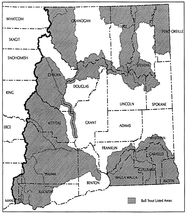
Bull Trout Overlay Map
PROPOSED RULES
Original Notice.
Preproposal statement of inquiry was filed as WSR 07-13-055.
Title of Rule and Other Identifying Information: Amend TITLE 222 WAC, Forest practices rules, related to northern spotted owl protection.
Hearing Location(s): Cowlitz County PUD, 961 12th Avenue, Kelso, on December 12, 2007, at 6 p.m.; at the Red Lion Hotel, 221 North Lincoln, Port Angeles, on December 19, 2007, at 6 p.m.; and at the Yakima County Building, 223 North First, Yakima, on January 8, 2008, at 6 p.m.
Date of Intended Adoption: February 13, 2008.
Submit Written Comments to: Patricia Anderson, Forest Practices Board, Department of Natural Resources, Forest Practices Division, P.O. Box 47012, Olympia, WA 98504-7012, e-mail forest.practicesboard@dnr.wa.gov, fax (360) 902-1428, by 5 p.m. on January 9, 2008.
Assistance for Persons with Disabilities: Contact forest practices division at (360) 902-1400, by November 30, 2007, TTY (360) 902-1125.
Purpose of the Proposal and Its Anticipated Effects, Including Any Changes in Existing Rules: The forest practices board proposes to amend the definition of "northern spotted owl site center" in WAC 222-16-010. The amendment would place a moratorium on the practice of "decertifying" northern spotted owl (NSO) site centers until December 31, 2008. This will extend NSO habitat protection provided by the rules at all Status 1, 2, and 3 NSO site centers recorded by the department of fish and wildlife as of November 1, 2005. This will allow time for the forest practices board to review its rules protecting NSO habitat and determine whether these rules need to be adjusted in light of NSO population declines, threats posed by barred owls, and changes in NSO habitat.
Reasons Supporting Proposal: Since the forest practices board adopted rules to protect the habitat of the NSO in
1996, the amount of suitable habitat within spotted owl special emphasis areas and outside areas that are being managed under the aegis of habitat conservation plans or similar agreements has declined by an average of 16%. Furthermore, fewer plans to conserve NSO habitat at a landscape level have been developed than was anticipated when the NSO rules were adopted. With few landscape-level plans, the forest practices rules continue to rely heavily on the regulation of timber harvest at individual spotted owl sites to provide habitat conservation. During 2008, the board will determine whether to change the forest practices rules pertaining to northern spotted owl habitat.
Statutory Authority for Adoption: RCW 76.09.040.
Statute Being Implemented: Not applicable.
Rule is not necessitated by federal law, federal or state court decision.
Name of Proponent: Forest practices board, governmental.
Name of Agency Personnel Responsible for Drafting and Enforcement: Leonard Young, 1111 Washington Street S.E., Olympia, (360) 902-1744; and Implementation: Gary Graves, 1111 Washington Street S.E., Olympia, (360) 902-1483.
A small business economic impact statement has been prepared under chapter 19.85 RCW.
The objective of this analysis is to estimate the benefits and the costs of a moratorium on northern spotted owl site center decertification from April 1, 2008, which is the approximate effective date of a new permanent rule, to December 31, 2008. For a base, it uses the data and methodology of a previous analysis produced for the board's 2006 permanent rule making that instituted the initial nineteen-month moratorium, hereinafter referred to as the 2006 economic analysis.1
Agencies are required to conduct economic analyses to aide in determining whether to adopt rules. The Administrative Procedure Act (chapter 34.05 RCW)2 requires completion of a cost-benefit analysis to determine whether the probable benefits of a proposed rule exceed its probable costs. A small business economic impact statement (SBEIS) is required by the Regulatory Fairness Act (chapter 19.85 RCW)3 to consider the impacts on small businesses. It compares the costs of compliance for small businesses with the cost of compliance for the 10% of businesses that are the largest businesses required to comply with the proposed rules. This document combines the cost-benefit analysis and the SBEIS.
CONTEXT: The forest practices board is made up of representatives of state natural resource agencies and general public members including representatives of both the small and large industrial forest land ownership groups. The board adopts rules to establish minimum standards for forest practices. In 1990, the board responded to the federal Endangered Species Act listing of the northern spotted owl by adopting a series of emergency rules to protect spotted owl habitat, and ultimately adopted permanent rules on May 22, 1996. These rules:
| • | Identify "critical wildlife habitat" (state) for the northern spotted owl. Forest practices applications within these areas that involve suitable spotted owl habitat are Class IV-Special, and require additional environmental review under SEPA (State Environmental Policy Act). The rules do not prohibit harvesting. |
| • | Provide SEPA guidance to DNR for threatened and endangered species, and specific SEPA guidance for the northern spotted owl. |
| • | Delineate ten "spotted owl special emphasis areas" (SOSEAs) where critical wildlife habitat (state) is designated within circles around owl site centers (owl circles). Habitat goals (functions) are identified on maps for each SOSEA. |
| • | Require SEPA review for seventy acres of habitat around owl site centers outside SOSEAs. This applies only during the nesting season, from March 1 to August 31. |
| • | Provide a small parcel exemption from SEPA for landowners who own less than 500 acres in a SOSEA, if the proposed forest practice is not within 0.7 mile of a site center. |
| • | Include two landscape planning processes: A landowner option plan for landowners currently impacted by spotted owls, and a cooperative habitat enhancement agreement for those not currently impacted by spotted owls. |
| • | Identify certain restrictions against disturbance around owl site centers inside SOSEAs during the nesting season. |
The goal of the 2006 rule was to maintain habitat and regulatory options until the United States Fish and Wildlife Service completed a draft northern spotted owl recovery plan, an effort that was originally scheduled for September 2006 completion. The board intended to consider the outcome of the draft plan when considering modifying the state rules. However, production of the draft plan took longer than anticipated; the draft plan was not available until April 2007.
On June 6, 2007, the board approved an emergency rule to extend the sunset date of the moratorium on site center decertification past June 30, 2007. The emergency rule expires on October 28, 2007. On July 25, 2007, the board approved the initiation of permanent rule making that would sunset the moratorium on December 31, 2008, with the objective of ensuring no loss of habitat while determining whether and how to modify the state rules to conserve habitat. The board may adopt another emergency rule to extend the moratorium past October 25, 2007, to ensure not [no] loss of habitat while the board decides whether to adopt the permanent rule proposal. This analysis, however, does not include the costs and benefits of any emergency rule timeframes.
INTRODUCTORY INFORMATION: The rule-complying community affected by the proposal is businesses that own or control the cutting rights on forest land or those with the right to dispose of the timber. For small forest landowners owning less than 500 acres in a SOSEA, the effects of the proposed rules are limited to habitat within the inner 0.7-mile circle. The Regulatory Fairness Act defines a "small business" as one with fifty or fewer employees. Ownership acreage is generally a more appropriate metric for characterizing small businesses in the timber industry. In this analysis, small businesses are identified as those subject to the small parcel exemption in WAC 222-16-080 [(1)](h)(iv) which states: "Forest practices proposed on the lands owned or controlled by a landowner whose forest land ownership within the SOSEA is less than or equal to 500 acres and where the forest practice is not within 0.7 mile of a northern spotted owl site center shall not be considered to be on lands designated as critical habitat (state) for northern spotted owls." All other private landowners are categorized as "large businesses" for purposes of this analysis.
The forest land affected by the moratorium is: (1) Habitat within owl site centers (circles) and within SOSEA boundaries, excluding forest land that is in an HCP, owned by the federal government, or covered by a landowner option plan; and (2) habitat within a designated seventy-acre area around site centers outside SOSEAs. However, for purposes of this analysis, the latter category of forest land was not considered to be affected by the moratorium because landowners can carry out forest practices within these areas outside the owl's breeding season. Portions of a given circle that also fall within one or more other Status 1, 2 or 3 circles are not considered decertified.
Costs and benefits are calculated on a per-acre basis for comparison purposes and are limited to direct costs and benefits. The costs of the rule change are measured as the potential loss of timber revenue, based on an estimate of the habitat acreage affected by the rule proposal, for the period of time covered by the rule currently proposed by the board, i.e., eighteen months. Benefits are defined as the value of protecting the habitat based on the findings of a 1993 study done in Oregon that estimated the value to state residents of protecting northern spotted owl habitat. This was the best information available to us, and we use it with the caveat that there are uncertainties regarding its application to this analysis. Methods are further discussed below.
METHODS OF ANALYSIS: We determined costs by estimating the volume and stumpage value of timber affected by the proposed rule and calculating the cost of withholding this timber from harvest during the period covered by the proposed rule - from April 1, 2008, which is the approximate effective date of the proposed rule, to December 31, 2008.
In the 2006 economic analysis, we estimated timber harvest revenue in a six-step process:
| Step 1. | Identify owl circles potentially affected by the rule change. |
| Step 2. | Analyze spotted owl circles identified in Step 1. |
| Step 3. | Determine forest acreage affected by the rule change. |
| Step 4. | Estimate habitat acreage. |
| Step 5. | Estimate habitat that would have been harvested without the rule change. |
| Step 6. | Determine costs associated with a moratorium on decertification. |
| Step 7. | Update the findings of the 2006 economic analysis to accommodate an additional nine-month moratorium. |
The effects on small businesses are highlighted where appropriate.
ANALYSIS:
Determining costs associated with a moratorium on decertification:
Step 1 - Identify owl circles potentially affected by the rule change. The Washington department of fish and wildlife provided a list of the spotted owl circles in which surveys were in progress or completed in anticipation of decertification. Five spotted owl circles were identified as potentially affected: Three in the I-90 East SOSEA located east of the Cascade Range Crest, and two in the Mineral Block SOSEA located on the west side. (An additional spotted owl circle in the process of decertification is not in a SOSEA, so is not affected by this proposal.)
Step 2 - Analyze spotted owl circles identified in Step 1. Circles that are entirely or partially within SOSEAs were analyzed using GIS to identify ownership (federal, state, industry, nonindustrial private), whether land parcels making up the circle were covered by a habitat conservation plan (HCP) or similar arrangement that exempted the area from forest practices rules pertaining to the spotted owl, and each parcel's seral stage(s). SOSEA boundaries and transecting Status 1, 2 and 3 spotted owl circles were also delineated, because the proposed rule does not affect the portion of circles outside of SOSEAs, or portions of decertified circles within SOSEAs that are also part of other Status 1, 2 or 3 circles.
Step 3 - Determine forest acreage affected by the rule change. Affected forest acreage was determined based on the GIS analysis. Forest acreage affected by the moratorium on decertification is limited to habitat within owl site circles within SOSEA boundaries, except acreage that is in an HCP, owned by the federal government, covered by a landowner option plan, or within one or more other Status 1, 2 or 3 circles. As previously explained, the effects on small forest landowners are limited to habitat within the inner 0.7-mile circle. If the circle includes more than 40% habitat, excess habitat is available for harvest.
Table 1 summarizes the amount of privately-owned forest acreage that is affected by the moratorium for the three owl circles on the east side and the two on the west side, as well as an estimate of the affected habitat acreage (discussed in Step 4 below). There are 14,407 acres potentially affected within the five owl circles included in the analysis; all but one hundred fifty-two acres are industrial forest land. These one hundred fifty-two acres are owned by landowners subject to the small parcel exemption provision.
| Industrial Acreage | |||
| Forest | Habitat | % Habitat | |
| East | 8123 | 2624 | 32.3 |
| West | 6132 | 369 | 6.0 |
| Total | 14255 | 2993 | 21.0 |
| Small Landowner Acreage | |||
| Forest | Habitat | % Habitat | |
| East | 152 | 26 | 17.1 |
| West | 0 | 0 | 0.0 |
| Total | 152 | 26 | 17.1 |
| Total Acreage | |||
| Forest | Habitat | % Habitat | |
| East | 8275 | 2650 | 32.0 |
| West | 6132 | 369 | 6.0 |
| Total | 14407 | 3019 | 21.0 |
| ZONE | OTHER SERAL | EARLY SERAL | MID SERAL | LATE SERAL |
| East Cascades | 2.1 | 12.5 | 58.8 | 65.7 |
| South Cascades | 2.1 | 0.4 | 45.0 | 60.9 |
Habitat is defined differently on the west and east sides
of the Cascade Range Crest, reflecting differences in northern
spotted owl behavior. This is apparent in the habitat acreage
estimates in Table 1. The proportion of habitat is much
higher in the east (32.0%) than in the west (6.0%). We
estimate there is a total of 3,019 acres of habitat affected
by the rule proposal; that is, 3,019 acres of habitat that
could have been harvested if the five owl circles were
decertified. Only twenty-six acres of this acreage is in the
small landowner category, leading us to conclude that the rule
making does not have a disproportionate effect on small
businesses.
Step 5 - Estimate habitat that would have been harvested without the rule change. While conducting the 2006 economic analysis, DNR field staff estimated that without the decertification moratorium, approximately 75% of the affected habitat would have been harvested. This amounts to 2,264 acres of forest land that could not be harvested because of the moratorium.
Step 6 - Determine costs associated with a moratorium on decertification. We calculated timber value by multiplying lost harvest acreage by average per-acre timber harvest revenue for western and eastern Washington. We estimated the stumpage revenue potential, assuming harvest of 75% of the habitat subject to the rule proposal in the five spotted owl circles. This calculation required that we make assumptions regarding the volume per acre and price. Stand quality and species composition are implicitly factored into these assumptions. For the 2006 economic analysis, the high-end estimate assumed volume of 50,000 board feet (fifty MBF) per acre at a price of $400 per MBF, and the low-end estimate assumed volume of forty MBF per acre at a price of $350 per MBF. Per-acre stumpage value was $20,000 and $14,000, respectively.
Step 7 - Update the findings of the 2006 economic analysis to accommodate an additional nine-month moratorium. The 2006 economic analysis limited the effects of the moratorium to those owl circles that had been surveyed at least once in anticipation of later decertification. The implied assumption was that the moratorium was temporary and thus did not affect other owl circles.
The first moratorium was in place from November 30, 2005, until June 30, 2007, a period of nineteen months. The proposed rule effectively extends this moratorium through December 31, 2008, a period of eighteen months, approximately the same length of time, though we are limiting our estimates of costs and benefits to the period covered by the proposed permanent rule which this analysis supports (April 1 through December 31, 2008). We are assuming that the pace of decertification activity would be about the same. The proposed moratorium extension thus affects the timber volume identified in the previous economic analysis, as well as additional timber volume approximately equal to that previously identified, thus doubling the affected acreage to 4,528 acres.
Determining benefits associated with a moratorium on decertification. The benefits of the moratorium are difficult to estimate. The intended purpose of the rule proposal is to help arrest the decline in northern spotted owl populations in Washington by providing additional habitat protection. Few studies have estimated values of protecting northern spotted owls or their habitat (Hagen et al 1992; Rubin et al 1991; Loomis et al 1996). These studies use the contingent valuation method (CV) to measure the willingness to pay (WTP) for protecting the northern spotted owl and old growth forests. This approach is widely accepted among federal agencies for benefit-cost analysis that measure the benefits of nonmarket goods such as an endangered species. While all three studies use a CV approach to measure benefits and costs of protecting the northern spotted owl, the study by Loomis et al. provides the preferred approach for our purpose, as it estimates benefits of an incremental change in protected habitat of a specified number of acres. The report on the findings is available at the United States Forest Service Pacific Southwest Research Service web site at http://www.fs.fed.us/psw/publications/documents/rp-229/.
The Loomis et al. study surveyed residents of the state of Oregon in 1993 on their WTP for protecting old growth northern spotted owl habitat from fire in the Pacific Northwest. Following is a discussion of the methodology used in the study, the WTP results, and the limitations that may apply in terms of the transferability of these results to Washington. We use these results to evaluate the probable benefits of protecting northern spotted owl habitat in Washington state, adjusting the results as necessary.
Survey participants were asked to evaluate a scenario whereby approximately 3,500 acres of old growth northern spotted owl habitat was saved from fire. The median WTP of survey respondents was $77 per household per year, which corresponded to $24,170 per acre for Oregon's 1.1 million residents in 1993. Assuming that nonrespondents (about half of those sent surveys) had a WTP of $0 provides a minimum value of $45 per household per year.
We adjusted these findings to account for inflation and the number of households in Washington. WTP of protecting 3,500 acres of habitat in Washington is estimated to be $104 per household per year, with a minimum value of $61. The benefit to the state's 2.5 million households amounts to an average of between $74,286 and $43,571 per acre. (Although these estimates are on a per-year basis, we have assumed they are a one-time payment to mitigate for the uncertainties with using this benefit valuation approach.)
Although this study was the most applicable to our analysis, there are a number of factors that might have an effect on its transferability, with the potential for over- or under-estimation. These include:
| • | The base study was limited to Oregon residents. Attitudes towards protecting the northern spotted owl may differ between the states. Higher average incomes in Washington suggest that WTP may be higher in Washington. |
| • | We extrapolated the Loomis et al. study results to Washington residents only; WTP for nonresidents was ignored, though it may be considerable. |
| • | The base study valued protecting old growth forests from fire. The rule changes under consideration protect all levels of habitat from general loss. Washington residents likely value less mature forests lower than old growth. Other benefits accruing from avoidance of fire would not be applicable to this analysis, possibly overstating benefits. |
| • | Attitudes towards protecting northern spotted owls and their habitat may have changed since 1993. |
| • | Placing a value on nonmarket goods such as habitat protection is difficult for some people. |
Costs and Benefits: This economic analysis estimates ranges of costs and benefits of instituting a moratorium on northern spotted owl site center decertification for a period of nine months. Costs are estimated as the opportunity loss of the timber harvest revenue that could have been accrued if the moratorium was not in place. Estimated benefits are based on a study of willingness to pay for protecting spotted owl habitat published in 1996.
The estimated stumpage value of 4,528 acres of timber range from $63.4 million to $90.6 million, and the value of protecting this habitat ranges from $196 million to $336 million. On a per-acre basis, stumpage value ranges from $14,000 to $20,000 per acre, and habitat value ranges from $43,571 to $74,286 per acre.
This analysis estimates costs and benefits of the proposed rule for the time period beginning April 1, 2008, and ending at the sunset date of the current proposed rule, December 31, 2008. In essence, this is the costs of foregoing harvest until 2009, assuming that harvest would have taken place at the beginning of the period (April 1, 2008) in the absence of a moratorium7. We assumed that the timber would continue to grow (appreciate) at a rate of 1% per year, and used a discount rate of 5% to represent the time value of money, resulting in a net discount rate of 4%. At this rate, the cost of withholding timber from harvest from April 1, 2008, until December 31, 2008, is approximately 3% of its value. The cost of the proposed rule is thus 2.84% of estimated stumpage value of affected acreage (4,528 acres), or between $1.8 and $2.6 million. Applying the same rate to estimated habitat value results in benefits of between $5.6 and $9.6 million.
| Total Cost | Cost Per Acre | Total Benefit | Benefit Per Acre | |
| High Estimate | $2.6 million | $1,140 | $9.6 million | $4,234 |
| Low Estimate | $1.8 million | $798 | $5.6 million | $2,484 |
Per-acre cost estimates are dependent on price, stand quality and species composition assumptions. In addition, this analysis assumes that the pace and scope of decertification requests during the period of time covered by this proposed rule would have been similar to that covered by the 2006 economic analysis. Costs may be lower if a landowner chooses to develop a landowner option plan, which exempts the landowner from these rules.
Benefit estimates are more uncertain due to the lack of market price signals for environmental amenities. Although survey respondents may have implicitly valued other amenities that accrue from protecting northern spotted owl habitat (such as habitat for other species, open space, and water quality), some of the ancillary benefits of protecting habitat may not have been captured by this analysis.
In spite of these uncertainties, estimated benefits are sufficiently greater than costs to provide a reasonable degree of certainty that the benefits of this rule making exceed the costs. It is worth noting, however, that this economic analysis estimates overall benefits and costs, not the distribution of costs and benefits (with the exception of impacts on small businesses, which in this case are minimal). The benefits of northern spotted owl habitat protection identified in this analysis will accrue to state residents in general, whereas the costs will primarily be borne by industrial forest landowners.
Small Business Impacts: The effects of the proposal on small forest landowners are limited to habitat within the inner 0.7-mile circle of spotted owl site centers within SOSEAs. We estimate that fifty-two acres of small forest landowner habitat are affected by the decertification provision of the proposed rules; this is less than 1% of the potentially affected habitat acreage8. There may be specific instances where individual small forest landowners are disproportionately affected, but small businesses are not affected disproportionately when compared to Washington timber industry businesses overall, and the number of small business jobs lost statewide as a result of this proposal would be negligible.
REFERENCES
Hagen, D., Vincent, J. and Welle, P., 1992. Benefits of preserving old-growth forest and the spotted owl. Contemp. Policy Issues, 10: 13-25.
Loomis, John B.; Gonzlez-Cabn, Armando; Gregory, Robin. 1996. A contingent valuation study of the value of reducing fire hazards to old-growth forests in the Pacific Northwest. Res. Paper PSW-RP-229-Web. Albany, CA: Pacific Southwest Research Station, Forest Service, U.S. Department of Agriculture; 24 p.
Pierce, D. J., J. B. Buchanan, B. L. Cosentino, and S. Snyder. 2005. An assessment of Spotted Owl habitat on non-federal lands in Washington between 1996 and 2004.
Final Report. Washington Department of Fish and Wildlife, Olympia, Washington, USA. 187 p.
Rubin, J.; Helfand, G., and Loomis, J. A benefit-cost analysis of the northern spotted owl: Results from a contingent valuation survey. Journal of Forestry. 1991; 89(12):25-30.
1 Economic Analysis, August 2006. See http://www.dnr.wa.gov/forestpractices/rules/activity/archive.html.
2 For CBA requirements, see RCW 34.05.328 - The Washington state legislature.
3 For SBEIS requirements, see RCW 19.85.040 - The Washington state legislature.
4 The decertification process follows the survey protocol endorsed by the United States Fish and Wildlife Service for spotted owl sites that are no longer occupied. The protocol states that "if no responses have been obtained from an historical site after three years of survey (using established guidelines), the site may be considered unoccupied, barring other evidence to the contrary." Unoccupied sites are changed to "status 5" and are not subject to forest practices rules pertaining to northern spotted owls.
5 Available at http://www.fs.fed.us/psw/publications/documents/rp-229/.
6 Available at http://wdfw.wa.gov/wlm/research/papers/spotted_owl/.
7 It is unknown when harvest would have taken place following decertification.
8 See Table 1 for the results of the 2006 Economic Analysis. We assume that the SFL proportion of affected acreage is the same in the additionally constrained acreage, thus doubling the findings of the 2006 economic analysis.
A copy of the statement may be obtained by contacting Gretchen Robinson, Department of Natural Resources, P.O. Box 47012, Olympia, WA 98504-7012, phone (360) 902-1705, fax (360) 902-1428, e-mail gretchen.robinson@dnr.wa.gov.
A cost-benefit analysis is required under RCW 34.05.328. A preliminary cost-benefit analysis may be obtained by contacting Gretchen Robinson, Department of Natural Resources, P.O. Box 47012, Olympia, WA 98504-7012, phone (360) 902-1705, fax (360) 902-1428, e-mail gretchen.robinson@dnr.wa.gov. Please note: The preliminary cost-benefit analysis and SBEIS are combined in the draft economic analysis.
October 30, 2007
Victoria Christiansen
Chair
OTS-1156.1
AMENDATORY SECTION(Amending WSR 07-20-044, filed 9/26/07,
effective 10/27/07)
WAC 222-16-010
*General definitions.
Unless otherwise
required by context, as used in these rules:
"Act" means the Forest Practices Act, chapter 76.09 RCW.
"Affected Indian tribe" means any federally recognized Indian tribe that requests in writing from the department information on forest practices applications and notification filed on specified areas.
"Alluvial fan" see "sensitive sites" definition.
"Appeals board" means the forest practices appeals board established in the act.
"Aquatic resources" means water quality, fish, the Columbia torrent salamander (Rhyacotriton kezeri), the Cascade torrent salamander (Rhyacotriton cascadae), the Olympic torrent salamander (Rhyacotriton olympian), the Dunn's salamander (Plethodon dunni), the Van Dyke's salamander (Plethodon vandyke), the tailed frog (Ascaphus truei) and their respective habitats.
"Area of resource sensitivity" means areas identified in accordance with WAC 222-22-050 (2)(d) or 222-22-060(2).
"Bankfull depth" means the average vertical distance between the channel bed and the estimated water surface elevation required to completely fill the channel to a point above which water would enter the flood plain or intersect a terrace or hillslope. In cases where multiple channels exist, the bankfull depth is the average depth of all channels along the cross-section. (See board manual section 2.)
"Bankfull width" means:
(a) For streams - the measurement of the lateral extent of the water surface elevation perpendicular to the channel at bankfull depth. In cases where multiple channels exist, bankfull width is the sum of the individual channel widths along the cross-section (see board manual section 2).
(b) For lakes, ponds, and impoundments - line of mean high water.
(c) For tidal water - line of mean high tide.
(d) For periodically inundated areas of associated wetlands - line of periodic inundation, which will be found by examining the edge of inundation to ascertain where the presence and action of waters are so common and usual, and so long continued in all ordinary years, as to mark upon the soil a character distinct from that of the abutting upland.
"Basal area" means the area in square feet of the cross section of a tree bole measured at 4 1/2 feet above the ground.
"Bedrock hollows" (colluvium-filled bedrock hollows, or hollows; also referred to as zero-order basins, swales, or bedrock depressions) means landforms that are commonly spoon-shaped areas of convergent topography within unchannelled valleys on hillslopes. (See board manual section 16 for identification criteria.)
"Board" means the forest practices board established by the act.
"Bog" means wetlands which have the following characteristics: Hydric organic soils (peat and/or muck) typically 16 inches or more in depth (except over bedrock or hardpan); and vegetation such as sphagnum moss, Labrador tea, bog laurel, bog rosemary, sundews, and sedges; bogs may have an overstory of spruce, western hemlock, lodgepole pine, western red cedar, western white pine, Oregon crabapple, or quaking aspen, and may be associated with open water. This includes nutrient-poor fens. (See board manual section 8.)
"Borrow pit" means an excavation site outside the limits of construction to provide material necessary to that construction, such as fill material for the embankments.
"Bull trout habitat overlay" means those portions of Eastern Washington streams containing bull trout habitat as identified on the department of fish and wildlife's bull trout map. Prior to the development of a bull trout field protocol and the habitat-based predictive model, the "bull trout habitat overlay" map may be modified to allow for locally-based corrections using current data, field knowledge, and best professional judgment. A landowner may meet with the departments of natural resources, fish and wildlife and, in consultation with affected tribes and federal biologists, determine whether certain stream reaches have habitat conditions that are unsuitable for supporting bull trout. If such a determination is mutually agreed upon, documentation submitted to the department will result in the applicable stream reaches no longer being included within the definition of bull trout habitat overlay. Conversely, if suitable bull trout habitat is discovered outside the current mapped range, those waters will be included within the definition of "bull trout habitat overlay" by a similar process.
|
"Chemicals" means substances applied to forest lands or timber including pesticides, fertilizers, and other forest chemicals.
"Clearcut" means a harvest method in which the entire stand of trees is removed in one timber harvesting operation. Except as provided in WAC 222-30-110, an area remains clearcut until:
It meets the minimum stocking requirements under WAC 222-34-010(2) or 222-34-020(2); and
The largest trees qualifying for the minimum stocking levels have survived on the area for five growing seasons or, if not, they have reached an average height of four feet.
"Columbia River Gorge National Scenic Area or CRGNSA" means the area established pursuant to the Columbia River Gorge National Scenic Area Act, 16 U.S.C. § 544b(a).
"CRGNSA special management area" means the areas designated in the Columbia River Gorge National Scenic Area Act, 16 U.S.C. § 544b(b) or revised pursuant to 16 U.S.C. § 544b(c). For purposes of this rule, the special management area shall not include any parcels excluded by 16 U.S.C. § 544f(o).
"CRGNSA special management area guidelines" means the guidelines and land use designations for forest practices developed pursuant to 16 U.S.C. § 544f contained in the CRGNSA management plan developed pursuant to 15 U.S.C. § 544d.
"Commercial tree species" means any species which is capable of producing a merchantable stand of timber on the particular site, or which is being grown as part of a Christmas tree or ornamental tree-growing operation.
"Completion of harvest" means the latest of:
Completion of removal of timber from the portions of forest lands harvested in the smallest logical unit that will not be disturbed by continued logging or an approved slash disposal plan for adjacent areas; or
Scheduled completion of any slash disposal operations where the department and the applicant agree within 6 months of completion of yarding that slash disposal is necessary or desirable to facilitate reforestation and agree to a time schedule for such slash disposal; or
Scheduled completion of any site preparation or rehabilitation of adjoining lands approved at the time of approval of the application or receipt of a notification: Provided, That delay of reforestation under this paragraph is permitted only to the extent reforestation would prevent or unreasonably hinder such site preparation or rehabilitation of adjoining lands.
"Constructed wetlands" means those wetlands voluntarily developed by the landowner. Constructed wetlands do not include wetlands created, restored, or enhanced as part of a mitigation procedure or wetlands inadvertently created as a result of current or past practices including, but not limited to: Road construction, landing construction, railroad construction, or surface mining.
"Contamination" means introducing into the atmosphere, soil, or water, sufficient quantities of substances as may be injurious to public health, safety or welfare, or to domestic, commercial, industrial, agriculture or recreational uses, or to livestock, wildlife, fish or other aquatic life.
"Convergent headwalls" (or headwalls) means teardrop-shaped landforms, broad at the ridgetop and terminating where headwaters converge into a single channel; they are broadly concave both longitudinally and across the slope, but may contain sharp ridges separating the headwater channels. (See board manual section 16 for identification criteria.)
"Conversion option harvest plan" means a voluntary plan developed by the landowner and approved by the local governmental entity indicating the limits of harvest areas, road locations, and open space.
"Conversion to a use other than commercial timber operation" means a bona fide conversion to an active use which is incompatible with timber growing.
"Cooperative habitat enhancement agreement (CHEA)" see WAC 222-16-105.
"Critical habitat (federal)" means the habitat of any threatened or endangered species designated as critical habitat by the United States Secretary of the Interior or Commerce under Sections 3 (5)(A) and 4 (a)(3) of the Federal Endangered Species Act.
"Critical nesting season" means for marbled murrelets - April 1 to August 31.
"Critical habitat (state)" means those habitats designated by the board in accordance with WAC 222-16-080.
"Cultural resources" means archaeological and historic sites and artifacts, and traditional religious, ceremonial and social uses and activities of affected Indian tribes.
"Cumulative effects" means the changes to the environment caused by the interaction of natural ecosystem processes with the effects of two or more forest practices.
"Daily peak activity" means for marbled murrelets - one hour before official sunrise to two hours after official sunrise and one hour before official sunset to one hour after official sunset.
"Debris" means woody vegetative residue less than 3 cubic feet in size resulting from forest practices activities which would reasonably be expected to cause significant damage to a public resource.
"Deep-seated landslides" means landslides in which most of the area of the slide plane or zone lies below the maximum rooting depth of forest trees, to depths of tens to hundreds of feet. (See board manual section 16 for identification criteria.)
"Demographic support" means providing sufficient suitable spotted owl habitat within the SOSEA to maintain the viability of northern spotted owl sites identified as necessary to meet the SOSEA goals.
"Department" means the department of natural resources.
"Desired future condition (DFC)" is a reference point on a pathway and not an endpoint for stands. DFC means the stand conditions of a mature riparian forest at 140 years of age, the midpoint between 80 and 200 years. Where basal area is the only stand attribute used to describe 140-year old stands, these are referred to as the "Target Basal Area."
"Diameter at breast height (dbh)" means the diameter of a tree at 4 1/2 feet above the ground measured from the uphill side.
"Dispersal habitat" see WAC 222-16-085(2).
"Dispersal support" means providing sufficient dispersal habitat for the interchange of northern spotted owls within or across the SOSEA, as necessary to meet SOSEA goals. Dispersal support is provided by a landscape consisting of stands of dispersal habitat interspersed with areas of higher quality habitat, such as suitable spotted owl habitat found within RMZs, WMZs or other required and voluntary leave areas.
"Drainage structure" means a construction technique or feature that is built to relieve surface runoff and/or intercepted ground water from roadside ditches to prevent excessive buildup in water volume and velocity. A drainage structure is not intended to carry any typed water. Drainage structures include structures such as: Cross drains, relief culverts, ditch diversions, water bars, or other such structures demonstrated to be equally effective.
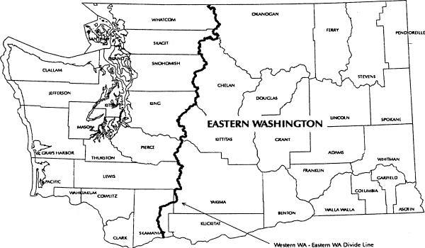
"Eastern Washington" means the geographic area in Washington east of the crest of the Cascade Mountains from the international border to the top of Mt. Adams, then east of the ridge line dividing the White Salmon River drainage from the Lewis River drainage and east of the ridge line dividing the Little White Salmon River drainage from the Wind River drainage to the Washington-Oregon state line.
 |
| Timber Habitat Types | Elevation Ranges |
| ponderosa pine | 0 - 2500 feet |
| mixed conifer | 2501 - 5000 feet |
| high elevation | above 5000 feet |
"End hauling" means the removal and transportation of excavated material, pit or quarry overburden, or landing or road cut material from the excavation site to a deposit site not adjacent to the point of removal.
"Equipment limitation zone" means a 30-foot wide zone measured horizontally from the outer edge of the bankfull width of a Type Np or Ns Water. It applies to all perennial and seasonal nonfish bearing streams.
"Erodible soils" means those soils that, when exposed or displaced by a forest practices operation, would be readily moved by water.
"Even-aged harvest methods" means the following harvest methods:
Clearcuts;
Seed tree harvests in which twenty or fewer trees per acre remain after harvest;
Shelterwood regeneration harvests in which twenty or fewer trees per acre remain after harvest;
Group or strip shelterwood harvests creating openings wider than two tree heights, based on dominant trees;
Shelterwood removal harvests which leave fewer than one hundred fifty trees per acre which are at least five years old or four feet in average height;
Partial cutting in which fewer than fifty trees per acre remain after harvest;
Overstory removal when more than five thousand board feet per acre is removed and fewer than fifty trees per acre at least ten feet in height remain after harvest; and
Other harvesting methods designed to manage for multiple age classes in which six or fewer trees per acre remain after harvest.
Except as provided above for shelterwood removal harvests and overstory removal, trees counted as remaining after harvest shall be at least ten inches in diameter at breast height and have at least the top one-third of the stem supporting green, live crowns. Except as provided in WAC 222-30-110, an area remains harvested by even-aged methods until it meets the minimum stocking requirements under WAC 222-34-010(2) or 222-34-020(2) and the largest trees qualifying for the minimum stocking levels have survived on the area for five growing seasons or, if not, they have reached an average height of four feet.
"Fen" means wetlands which have the following characteristics: Peat soils 16 inches or more in depth (except over bedrock); and vegetation such as certain sedges, hardstem bulrush and cattails; fens may have an overstory of spruce and may be associated with open water.
"Fertilizers" means any substance or any combination or mixture of substances used principally as a source of plant food or soil amendment.
"Fill" means the placement of earth material or aggregate for road or landing construction or other similar activities.
"Fish" means for purposes of these rules, species of the vertebrate taxonomic groups of Cephalospidomorphi and Osteichthyes.
"Fish habitat" means habitat, which is used by fish at any life stage at any time of the year including potential habitat likely to be used by fish, which could be recovered by restoration or management and includes off-channel habitat.
"Fish passage barrier" means any artificial in-stream structure that impedes the free passage of fish.
"Flood level - 100 year" means a calculated flood event flow based on an engineering computation of flood magnitude that has a 1 percent chance of occurring in any given year. For purposes of field interpretation, landowners may use the following methods:
Flow information from gauging stations;
Field estimate of water level based on guidance for "Determining the 100-Year Flood Level" in the forest practices board manual section 2.
The 100-year flood level shall not include those lands that can reasonably be expected to be protected from flood waters by flood control devices maintained by or under license from the federal government, the state, or a political subdivision of the state.
"Forest land" means all land which is capable of supporting a merchantable stand of timber and is not being actively used for a use which is incompatible with timber growing. Forest land does not include agricultural land that is or was enrolled in the conservation reserve enhancement program by contract if such agricultural land was historically used for agricultural purposes and the landowner intends to continue to use the land for agricultural purposes in the future. For small forest landowner road maintenance and abandonment planning only, the term "forest land" excludes the following:
(a) Residential home sites. A residential home site may be up to five acres in size, and must have an existing structure in use as a residence;
(b) Cropfields, orchards, vineyards, pastures, feedlots, fish pens, and the land on which appurtenances necessary to the production, preparation, or sale of crops, fruit, dairy products, fish, and livestock exist.
"Forest landowner" means any person in actual control of forest land, whether such control is based either on legal or equitable title, or on any other interest entitling the holder to sell or otherwise dispose of any or all of the timber on such land in any manner. However, any lessee or other person in possession of forest land without legal or equitable title to such land shall be excluded from the definition of "forest landowner" unless such lessee or other person has the right to sell or otherwise dispose of any or all of the timber located on such forest land. The following definitions apply only to road maintenance and abandonment planning:
(1) "Large forest landowner" is a forest landowner who is not a small forest landowner.
(2) "Small forest landowner" is a forest landowner who at the time of submitting a forest practices application or notification meets all of the following conditions:
• Has an average annual timber harvest level of two million board feet or less from their own forest lands in Washington state;
• Did not exceed this annual average harvest level in the three year period before submitting a forest practices application or notification;
• Certifies to the department that they will not exceed this annual harvest level in the ten years after submitting the forest practices application or notification.
However, the department will agree that an applicant is a small forest landowner if the landowner can demonstrate that the harvest levels were exceeded in order to raise funds to pay estate taxes or to meet equally compelling and unexpected obligations such as court-ordered judgments and extraordinary medical expenses.
"Forest practice" means any activity conducted on or directly pertaining to forest land and relating to growing, harvesting, or processing timber, including but not limited to:
Road and trail construction;
Harvesting, final and intermediate;
Precommercial thinning;
Reforestation;
Fertilization;
Prevention and suppression of diseases and insects;
Salvage of trees; and
Brush control.
"Forest practice" shall not include: Forest species seed orchard operations and intensive forest nursery operations; or preparatory work such as tree marking, surveying and road flagging; or removal or harvest of incidental vegetation from forest lands such as berries, ferns, greenery, mistletoe, herbs, mushrooms, and other products which cannot normally be expected to result in damage to forest soils, timber or public resources.
"Forest road" means ways, lanes, roads, or driveways on forest land used since 1974 for forest practices. "Forest road" does not include skid trails, highways, or local government roads except where the local governmental entity is a forest landowner. For road maintenance and abandonment planning purposes only, "forest road" does not include forest roads used exclusively for residential access located on a small forest landowner's forest land.
"Forest trees" does not include hardwood trees cultivated by agricultural methods in growing cycles shorter than 15 years if the trees were planted on land that was not in forest use immediately before the trees were planted and before the land was prepared for planting the trees. "Forest trees" includes Christmas trees but does not include Christmas trees that are cultivated by agricultural methods, as that term is defined in RCW 84.33.035.
"Full bench road" means a road constructed on a side hill without using any of the material removed from the hillside as a part of the road. This construction technique is usually used on steep or unstable slopes.
"Green recruitment trees" means those trees left after harvest for the purpose of becoming future wildlife reserve trees under WAC 222-30-020(11).
"Ground water recharge areas for glacial deep-seated slides" means the area upgradient that can contribute water to the landslide, assuming that there is an impermeable perching layer in or under a deep-seated landslide in glacial deposits. (See board manual section 16 for identification criteria.)
"Headwater spring" means a permanent spring at the head of a perennial channel. Where a headwater spring can be found, it will coincide with the uppermost extent of Type Np Water.
"Herbicide" means any substance or mixture of substances intended to prevent, destroy, repel, or mitigate any tree, bush, weed or algae and other aquatic weeds.
"Historic site" includes:
Sites, areas and structures or other evidence of human activities illustrative of the origins, evolution and development of the nation, state or locality; or
Places associated with a personality important in history; or
Places where significant historical events are known to have occurred even though no physical evidence of the event remains.
"Horizontal distance" means the distance between two points measured at a zero percent slope.
"Hyporheic" means an area adjacent to and below channels where interstitial water is exchanged with channel water and water movement is mainly in the downstream direction.
"Identified watershed processes" means the following components of natural ecological processes that may in some instances be altered by forest practices in a watershed:
Mass wasting;
Surface and road erosion;
Seasonal flows including hydrologic peak and low flows and annual yields (volume and timing);
Large organic debris;
Shading; and
Stream bank and bed stability.
"Inner gorges" means canyons created by a combination of the downcutting action of a stream and mass movement on the slope walls; they commonly show evidence of recent movement, such as obvious landslides, vertical tracks of disturbance vegetation, or areas that are concave in contour and/or profile. (See board manual section 16 for identification criteria.)
"Insecticide" means any substance or mixture of substances intended to prevent, destroy, repel, or mitigate any insect, other arthropods or mollusk pests.
"Interdisciplinary team" (ID Team) means a group of varying size comprised of individuals having specialized expertise, assembled by the department to respond to technical questions associated with a proposed forest practices activity.
"Islands" means any island surrounded by salt water in Kitsap, Mason, Jefferson, Pierce, King, Snohomish, Skagit, Whatcom, Island, or San Juan counties.
"Limits of construction" means the area occupied by the completed roadway or landing, including the cut bank, fill slope, and the area cleared for the purpose of constructing the roadway or landing.
"Load bearing portion" means that part of the road, landing, etc., which is supportive soil, earth, rock or other material directly below the working surface and only the associated earth structure necessary for support.
"Local governmental entity" means the governments of counties and the governments of cities and towns as defined in chapter 35.01 RCW.
"Low impact harvest" means use of any logging equipment, methods, or systems that minimize compaction or disturbance of soils and vegetation during the yarding process. The department shall determine such equipment, methods or systems in consultation with the department of ecology.
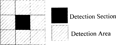
"Marbled murrelet detection area" means an area of land
associated with a visual or audible detection of a marbled
murrelet, made by a qualified surveyor which is documented and
recorded in the department of fish and wildlife data base. The marbled murrelet detection area shall be comprised of the
section of land in which the marbled murrelet detection was
made and the eight sections of land immediately adjacent to
that section.
 |
"Median home range circle" means a circle, with a specified radius, centered on a spotted owl site center. The radius for the median home range circle in the Hoh-Clearwater/Coastal Link SOSEA is 2.7 miles; for all other SOSEAs the radius is 1.8 miles.
"Merchantable stand of timber" means a stand of trees that will yield logs and/or fiber:
Suitable in size and quality for the production of lumber, plywood, pulp or other forest products;
Of sufficient value at least to cover all the costs of harvest and transportation to available markets.
"Multiyear permit" means a permit to conduct forest practices which is effective for longer than two years but no longer than five years.
"Northern spotted owl site center" means:
(1) Until ((June 30, 2007)) December 31, 2008, the
location of northern spotted owls:
(a) Recorded by the department of fish and wildlife as status 1, 2 or 3 as of November 1, 2005; or
(b) Newly discovered, and recorded by the department of fish and wildlife as status 1, 2 or 3 after November 1, 2005.
(2) After ((June 30, 2007)) December 31, 2008, the
location of status 1, 2 or 3 northern spotted owls based on
the following definitions:
| Status 1: | Pair or reproductive - a male and female heard and/or observed in close proximity to each other on the same visit, a female detected on a nest, or one or both adults observed with young. |
| Status 2: | Two birds, pair status unknown - the presence or response of two birds of opposite sex where pair status cannot be determined and where at least one member meets the resident territorial single requirements. |
| Status 3: | Resident territorial single - the presence or response of a single owl within the same general area on three or more occasions within a breeding season with no response by an owl of the opposite sex after a complete survey; or three or more responses over several years (i.e., two responses in year one and one response in year two, for the same general area). |
"Notice to comply" means a notice issued by the department pursuant to RCW 76.09.090 of the act and may require initiation and/or completion of action necessary to prevent, correct and/or compensate for material damage to public resources which resulted from forest practices.
"Occupied marbled murrelet site" means:
(1) A contiguous area of suitable marbled murrelet habitat where at least one of the following marbled murrelet behaviors or conditions occur:
(a) A nest is located; or
(b) Downy chicks or eggs or egg shells are found; or
(c) Marbled murrelets are detected flying below, through, into or out of the forest canopy; or
(d) Birds calling from a stationary location within the area; or
(e) Birds circling above a timber stand within one tree height of the top of the canopy; or
(2) A contiguous forested area, which does not meet the definition of suitable marbled murrelet habitat, in which any of the behaviors or conditions listed above has been documented by the department of fish and wildlife and which is distinguishable from the adjacent forest based on vegetative characteristics important to nesting marbled murrelets.
(3) For sites defined in (1) and (2) above, the sites will be presumed to be occupied based upon observation of circling described in (1)(e), unless a two-year survey following the 2003 Pacific Seabird Group (PSG) protocol has been completed and an additional third-year of survey following a method listed below is completed and none of the behaviors or conditions listed in (1)(a) through (d) of this definition are observed. The landowner may choose one of the following methods for the third-year survey:
(a) Conduct a third-year survey with a minimum of nine visits conducted in compliance with 2003 PSG protocol. If one or more marbled murrelets are detected during any of these nine visits, three additional visits conducted in compliance with the protocol of the first nine visits shall be added to the third-year survey. Department of fish and wildlife shall be consulted prior to initiating third-year surveys; or
(b) Conduct a third-year survey designed in consultation with the department of fish and wildlife to meet site specific conditions.
(4) For sites defined in (1) above, the outer perimeter of the occupied site shall be presumed to be the closer, measured from the point where the observed behaviors or conditions listed in (1) above occurred, of the following:
(a) 1.5 miles from the point where the observed behaviors or conditions listed in (1) above occurred; or
(b) The beginning of any gap greater than 300 feet wide lacking one or more of the vegetative characteristics listed under "suitable marbled murrelet habitat"; or
(c) The beginning of any narrow area of "suitable marbled murrelet habitat" less than 300 feet in width and more than 300 feet in length.
(5) For sites defined under (2) above, the outer perimeter of the occupied site shall be presumed to be the closer, measured from the point where the observed behaviors or conditions listed in (1) above occurred, of the following:
(a) 1.5 miles from the point where the observed behaviors or conditions listed in (1) above occurred; or
(b) The beginning of any gap greater than 300 feet wide lacking one or more of the distinguishing vegetative characteristics important to murrelets; or
(c) The beginning of any narrow area of suitable marbled murrelet habitat, comparable to the area where the observed behaviors or conditions listed in (1) above occurred, less than 300 feet in width and more than 300 feet in length.
(6) In determining the existence, location and status of occupied marbled murrelet sites, the department shall consult with the department of fish and wildlife and use only those sites documented in substantial compliance with guidelines or protocols and quality control methods established by and available from the department of fish and wildlife.
"Old forest habitat" see WAC 222-16-085 (1)(a).
"Operator" means any person engaging in forest practices except an employee with wages as his/her sole compensation.
"Ordinary high-water mark" means the mark on the shores of all waters, which will be found by examining the beds and banks and ascertaining where the presence and action of waters are so common and usual, and so long continued in all ordinary years, as to mark upon the soil a character distinct from that of the abutting upland, in respect to vegetation: Provided, That in any area where the ordinary high-water mark cannot be found, the ordinary high-water mark adjoining saltwater shall be the line of mean high tide and the ordinary high-water mark adjoining freshwater shall be the line of mean high-water.
"Other forest chemicals" means fire retardants when used to control burning (other than water), nontoxic repellents, oil, dust-control agents (other than water), salt, and other chemicals used in forest management, except pesticides and fertilizers, that may present hazards to the environment.
"Park" means any park included on the parks register maintained by the department pursuant to WAC 222-20-100(2). Developed park recreation area means any park area developed for high density outdoor recreation use.
"Partial cutting" means the removal of a portion of the merchantable volume in a stand of timber so as to leave an uneven-aged stand of well-distributed residual, healthy trees that will reasonably utilize the productivity of the soil. Partial cutting does not include seedtree or shelterwood or other types of regeneration cutting.
"Pesticide" means any insecticide, herbicide, fungicide, or rodenticide, but does not include nontoxic repellents or other forest chemicals.
"Plantable area" is an area capable of supporting a commercial stand of timber excluding lands devoted to permanent roads, utility rights of way, that portion of riparian management zones where scarification is not permitted, and any other area devoted to a use incompatible with commercial timber growing.
"Power equipment" means all machinery operated with fuel burning or electrical motors, including heavy machinery, chain saws, portable generators, pumps, and powered backpack devices.
"Preferred tree species" means the following species listed in descending order of priority for each timber habitat type:
| Ponderosa pine habitat type |
Mixed conifer habitat type |
| all hardwoods | all hardwoods |
| ponderosa pine | western larch |
| western larch | ponderosa pine |
| Douglas-fir | western red cedar |
| western red cedar | western white pine |
| Douglas-fir | |
| lodgepole pine |
"Qualified surveyor" means an individual who has successfully completed the marbled murrelet field training course offered by the department of fish and wildlife or its equivalent.
"Rehabilitation" means the act of renewing, or making usable and reforesting forest land which was poorly stocked or previously nonstocked with commercial species.
"Resource characteristics" means the following specific measurable characteristics of fish, water, and capital improvements of the state or its political subdivisions:
For fish and water:
Physical fish habitat, including temperature and turbidity;
Turbidity in hatchery water supplies; and
Turbidity and volume for areas of water supply.
For capital improvements of the state or its political subdivisions:
Physical or structural integrity.
If the methodology is developed and added to the manual to analyze the cumulative effects of forest practices on other characteristics of fish, water, and capital improvements of the state or its subdivisions, the board shall amend this list to include these characteristics.
"Riparian function" includes bank stability, the recruitment of woody debris, leaf litter fall, nutrients, sediment filtering, shade, and other riparian features that are important to both riparian forest and aquatic system conditions.
"Riparian management zone (RMZ)" means:
(1) For Western Washington
(a) The area protected on each side of a Type S or F Water measured horizontally from the outer edge of the bankfull width or the outer edge of the CMZ, whichever is greater (see table below); and
| Site Class | Western Washington Total RMZ Width |
| I | 200' |
| II | 170' |
| III | 140' |
| IV | 110' |
| V | 90' |
(2) For Eastern Washington
(a) The area protected on each side of a Type S or F Water measured horizontally from the outer edge of the bankfull width or the outer edge of the CMZ, whichever is greater (see table below); and
| Site Class | Eastern Washington Total RMZ Width |
| I | 130' |
| II | 110' |
| III | 90' or 100'* |
| IV | 75' or 100'* |
| V | 75' or 100'* |
| * | Dependent upon stream size. (See WAC 222-30-022.) |
(3) For exempt 20 acre parcels, a specified area alongside Type S and F Waters where specific measures are taken to protect water quality and fish and wildlife habitat.
"RMZ core zone" means:
(1) For Western Washington, the 50 foot buffer of a Type S or F Water, measured horizontally from the outer edge of the bankfull width or the outer edge of the channel migration zone, whichever is greater. (See WAC 222-30-021.)
(2) For Eastern Washington, the thirty foot buffer of a Type S or F Water, measured horizontally from the outer edge of the bankfull width or the outer edge of the channel migration zone, whichever is greater. (See WAC 222-30-022.)
"RMZ inner zone" means:
(1) For Western Washington, the area measured horizontally from the outer boundary of the core zone of a Type S or F Water to the outer limit of the inner zone. The outer limit of the inner zone is determined based on the width of the affected water, site class and the management option chosen for timber harvest within the inner zone. (See WAC 222-30-021.)
(2) For Eastern Washington, the area measured horizontally from the outer boundary of the core zone 45 feet (for streams less than 15 feet wide) or 70 feet (for streams more than 15 feet wide) from the outer boundary of the core zone. (See WAC 222-30-022.)
"RMZ outer zone" means the area measured horizontally between the outer boundary of the inner zone and the RMZ width as specified in the riparian management zone definition above. RMZ width is measured from the outer edge of the bankfull width or the outer edge of the channel migration zone, whichever is greater. (See WAC 222-30-021 and 222-30-022.)
"Road construction" means either of the following:
(a) Establishing any new forest road;
(b) Road work located outside an existing forest road prism, except for road maintenance.
"Road maintenance" means either of the following:
(a) All road work located within an existing forest road prism;
(b) Road work located outside an existing forest road prism specifically related to maintaining water control, road safety, or visibility, such as:
• Maintaining, replacing, and installing drainage structures;
• Controlling road-side vegetation;
• Abandoning forest roads according to the process outlined in WAC 222-24-052(3).
"Rodenticide" means any substance or mixture of substances intended to prevent, destroy, repel, or mitigate rodents or any other vertebrate animal which the director of the state department of agriculture may declare by regulation to be a pest.
"Salvage" means the removal of snags, down logs, windthrow, or dead and dying material.
"Scarification" means loosening the topsoil and/or disrupting the forest floor in preparation for regeneration.
"Sensitive sites" are areas near or adjacent to Type Np Water and have one or more of the following:
(1) Headwall seep is a seep located at the toe of a cliff or other steep topographical feature and at the head of a Type Np Water which connects to the stream channel network via overland flow, and is characterized by loose substrate and/or fractured bedrock with perennial water at or near the surface throughout the year.
(2) Side-slope seep is a seep within 100 feet of a Type Np Water located on side-slopes which are greater than 20 percent, connected to the stream channel network via overland flow, and characterized by loose substrate and fractured bedrock, excluding muck with perennial water at or near the surface throughout the year. Water delivery to the Type Np channel is visible by someone standing in or near the stream.
(3) Type Np intersection is the intersection of two or more Type Np Waters.
(4) Headwater spring means a permanent spring at the head of a perennial channel. Where a headwater spring can be found, it will coincide with the uppermost extent of Type Np Water.
(5) Alluvial fan means a depositional land form consisting of cone-shaped deposit of water-borne, often coarse-sized sediments.
(a) The upstream end of the fan (cone apex) is typically characterized by a distinct increase in channel width where a stream emerges from a narrow valley;
(b) The downstream edge of the fan is defined as the sediment confluence with a higher order channel; and
(c) The lateral margins of a fan are characterized by distinct local changes in sediment elevation and often show disturbed vegetation.
Alluvial fan does not include features that were formed under climatic or geologic conditions which are not currently present or that are no longer dynamic.
"Shorelines of the state" shall have the same meaning as in RCW 90.58.030 (Shoreline Management Act).
"Side casting" means the act of moving excavated material to the side and depositing such material within the limits of construction or dumping over the side and outside the limits of construction.
"Site class" means a grouping of site indices that are used to determine the 50-year or 100-year site class. In order to determine site class, the landowner will obtain the site class index from the state soil survey, place it in the correct index range shown in the two tables provided in this definition, and select the corresponding site class. The site class will then drive the RMZ width. (See WAC 222-30-021 and 222-30-022.)
(1) For Western Washington
| Site class | 50-year site index range (state soil survey) |
| I | 137+ |
| II | 119-136 |
| III | 97-118 |
| IV | 76-96 |
| V | <75 |
| Site class | 100-year site
index range (state soil survey) |
50-year site index range (state soil survey) |
| I | 120+ | 86+ |
| II | 101-120 | 72-85 |
| III | 81-100 | 58-71 |
| IV | 61-80 | 44-57 |
| V | ≤60 | <44 |
(a) If the site index in the soil survey is for red alder, and the whole RMZ width is within that site index, then use site class V. If the red alder site index is only for a portion of the RMZ width, or there is on-site evidence that the site has historically supported conifer, then use the site class for conifer in the most physiographically similar adjacent soil polygon.
(b) In Western Washington, if no site index is reported in the soil survey, use the site class for conifer in the most physiographically similar adjacent soil polygon.
(c) In Eastern Washington, if no site index is reported in the soil survey, assume site class III, unless site specific information indicates otherwise.
(d) If the site index is noncommercial or marginally commercial, then use site class V.
See also section 7 of the board manual.
"Site preparation" means those activities associated with the removal of slash in preparing a site for planting and shall include scarification and/or slash burning.
"Skid trail" means a route used by tracked or wheeled skidders to move logs to a landing or road.
"Slash" means pieces of woody material containing more than 3 cubic feet resulting from forest practices activities.
"Small forest landowner long-term application" means a proposal from a small forest landowner to conduct forest practices activities for terms of three to fifteen years. Small forest landowners as defined in WAC 222-21-010(13) are eligible to submit long-term applications.
"SOSEA goals" means the goals specified for a spotted owl special emphasis area as identified on the SOSEA maps (see WAC 222-16-086). SOSEA goals provide for demographic and/or dispersal support as necessary to complement the northern spotted owl protection strategies on federal land within or adjacent to the SOSEA.
"Spoil" means excess material removed as overburden or generated during road or landing construction which is not used within limits of construction.
"Spotted owl dispersal habitat" see WAC 222-16-085(2).
"Spotted owl special emphasis areas (SOSEA)" means the geographic areas as mapped in WAC 222-16-086. Detailed maps of the SOSEAs indicating the boundaries and goals are available from the department at its regional offices.
"Stop work order" means the "stop work order" defined in RCW 76.09.080 of the act and may be issued by the department to stop violations of the forest practices chapter or to prevent damage and/or to correct and/or compensate for damages to public resources resulting from forest practices.
"Stream-adjacent parallel roads" means roads (including associated right of way clearing) in a riparian management zone on a property that have an alignment that is parallel to the general alignment of the stream, including roads used by others under easements or cooperative road agreements. Also included are stream crossings where the alignment of the road continues to parallel the stream for more than 250 feet on either side of the stream. Not included are federal, state, county or municipal roads that are not subject to forest practices rules, or roads of another adjacent landowner.
"Sub-mature habitat" see WAC 222-16-085 (1)(b).
"Suitable marbled murrelet habitat" means a contiguous forested area containing trees capable of providing nesting opportunities:
(1) With all of the following indicators unless the department, in consultation with the department of fish and wildlife, has determined that the habitat is not likely to be occupied by marbled murrelets:
(a) Within 50 miles of marine waters;
(b) At least forty percent of the dominant and codominant trees are Douglas-fir, western hemlock, western red cedar or sitka spruce;
(c) Two or more nesting platforms per acre;
(d) At least 7 acres in size, including the contiguous forested area within 300 feet of nesting platforms, with similar forest stand characteristics (age, species composition, forest structure) to the forested area in which the nesting platforms occur.
"Suitable spotted owl habitat" see WAC 222-16-085(1).
"Temporary road" means a forest road that is constructed and intended for use during the life of an approved forest practices application/notification. All temporary roads must be abandoned in accordance to WAC 222-24-052(3).
"Threaten public safety" means to increase the risk to the public at large from snow avalanches, identified in consultation with the department of transportation or a local government, or landslides or debris torrents caused or triggered by forest practices.
"Threatened or endangered species" means all species of wildlife listed as "threatened" or "endangered" by the United States Secretary of the Interior or Commerce, and all species of wildlife designated as "threatened" or "endangered" by the Washington fish and wildlife commission.
"Timber" means forest trees, standing or down, of a commercial species, including Christmas trees. However, timber does not include Christmas trees that are cultivated by agricultural methods, as that term is defined in RCW 84.33.035.
"Unconfined avulsing stream" means generally fifth order or larger waters that experience abrupt shifts in channel location, creating a complex flood plain characterized by extensive gravel bars, disturbance species of vegetation of variable age, numerous side channels, wall-based channels, oxbow lakes, and wetland complexes. Many of these streams have dikes and levees that may temporarily or permanently restrict channel movement.
"Validation," as used in WAC 222-20-016, means the department's agreement that a small forest landowner has correctly identified and classified resources, and satisfactorily completed a roads assessment for the geographic area described in Step 1 of a long-term application.
"Water bar" means a diversion ditch and/or hump in a trail or road for the purpose of carrying surface water runoff into the vegetation duff, ditch, or other dispersion area so that it does not gain the volume and velocity which causes soil movement and erosion.
"Watershed administrative unit (WAU)" means an area shown on the map specified in WAC 222-22-020(1).
"Watershed analysis" means, for a given WAU, the assessment completed under WAC 222-22-050 or 222-22-060 together with the prescriptions selected under WAC 222-22-070 and shall include assessments completed under WAC 222-22-050 where there are no areas of resource sensitivity.
"Weed" is any plant which tends to overgrow or choke out more desirable vegetation.
"Western Washington" means the geographic area of Washington west of the Cascade crest and the drainages defined in Eastern Washington.
"Wetland" means those areas that are inundated or saturated by surface or ground water at a frequency and duration sufficient to support, and under normal circumstances do support, a prevalence of vegetation typically adapted for life in saturated soil conditions, such as swamps, bogs, fens, and similar areas. This includes wetlands created, restored, or enhanced as part of a mitigation procedure. This does not include constructed wetlands or the following surface waters of the state intentionally constructed from wetland sites: Irrigation and drainage ditches, grass lined swales, canals, agricultural detention facilities, farm ponds, and landscape amenities.
"Wetland functions" include the protection of water quality and quantity, providing fish and wildlife habitat, and the production of timber.
"Wetland management zone" means a specified area adjacent to Type A and B Wetlands where specific measures are taken to protect the wetland functions.
"Wildlife" means all species of the animal kingdom whose members exist in Washington in a wild state. The term "wildlife" includes, but is not limited to, any mammal, bird, reptile, amphibian, fish, or invertebrate, at any stage of development. The term "wildlife" does not include feral domestic mammals or the family Muridae of the order Rodentia (old world rats and mice).
"Wildlife reserve trees" means those defective, dead, damaged, or dying trees which provide or have the potential to provide habitat for those wildlife species dependent on standing trees. Wildlife reserve trees are categorized as follows:
Type 1 wildlife reserve trees are defective or deformed live trees that have observably sound tops, limbs, trunks, and roots. They may have part of the top broken out or have evidence of other severe defects that include: "Cat face," animal chewing, old logging wounds, weather injury, insect attack, or lightning strike. Unless approved by the landowner, only green trees with visible cavities, nests, or obvious severe defects capable of supporting cavity dependent species shall be considered as Type 1 wildlife reserve trees. These trees must be stable and pose the least hazard for workers.
Type 2 wildlife reserve trees are dead Type 1 trees with sound tops, limbs, trunks, and roots.
Type 3 wildlife reserve trees are live or dead trees with unstable tops or upper portions. Unless approved by the landowner, only green trees with visible cavities, nests, or obvious severe defects capable of supporting cavity dependent species shall be considered as Type 3 wildlife reserve trees. Although the roots and main portion of the trunk are sound, these reserve trees pose high hazard because of the defect in live or dead wood higher up in the tree.
Type 4 wildlife reserve trees are live or dead trees with unstable trunks or roots, with or without bark. This includes "soft snags" as well as live trees with unstable roots caused by root rot or fire. These trees are unstable and pose a high hazard to workers.
"Windthrow" means a natural process by which trees are uprooted or sustain severe trunk damage by the wind.
"Yarding corridor" means a narrow, linear path through a riparian management zone to allow suspended cables necessary to support cable logging methods or suspended or partially suspended logs to be transported through these areas by cable logging methods.
"Young forest marginal habitat" see WAC 222-16-085 (1)(b).
[Statutory Authority: RCW 76.09.040, 76.09.010 (2)(d). 07-20-044, § 222-16-010, filed 9/26/07, effective 10/27/07. Statutory Authority: [RCW 76.09.040]. 06-17-128, § 222-16-010, filed 8/21/06, effective 9/21/06; 06-11-112, § 222-16-010, filed 5/18/06, effective 6/18/06; 05-12-119, § 222-16-010, filed 5/31/05, effective 7/1/05; 04-05-087, § 222-16-010, filed 2/17/04, effective 3/19/04. Statutory Authority: Chapter 34.05 RCW, RCW 76.09.040, [76.09.]050, [76.09.]370, 76.13.120(9). 01-12-042, § 222-16-010, filed 5/30/01, effective 7/1/01. Statutory Authority: RCW 76.09.040 and chapter 34.05 RCW. 98-07-047, § 222-16-010, filed 3/13/98, effective 5/1/98; 97-24-091, § 222-16-010, filed 12/3/97, effective 1/3/98; 97-15-105, § 222-16-010, filed 7/21/97, effective 8/21/97. Statutory Authority: Chapters 76.09 and 34.05 RCW. 96-12-038, § 222-16-010, filed 5/31/96, effective 7/1/96. Statutory Authority: RCW 76.09.040 and chapter 34.05 RCW. 94-17-033, § 222-16-010, filed 8/10/94, effective 8/13/94; 93-12-001, § 222-16-010, filed 5/19/93, effective 6/19/93. Statutory Authority: RCW 76.09.040, 76.09.050 and chapter 34.05 RCW. 92-15-011, § 222-16-010, filed 7/2/92, effective 8/2/92. Statutory Authority: RCW 76.09.040, 76.09.050 and 34.05.350. 92-03-028, § 222-16-010, filed 1/8/92, effective 2/8/92; 91-23-052, § 222-16-010, filed 11/15/91, effective 12/16/91. Statutory Authority: RCW 76.09.040. 88-19-112 (Order 551, Resolution No. 88-1), § 222-16-010, filed 9/21/88, effective 11/1/88; 87-23-036 (Order 535), § 222-16-010, filed 11/16/87, effective 1/1/88. Statutory Authority: RCW 76.09.040 and 76.09.050. 82-16-077 (Resolution No. 82-1), § 222-16-010, filed 8/3/82, effective 10/1/82; Order 263, § 222-16-010, filed 6/16/76.]