PROPOSED RULES
Original Notice.
Preproposal statement of inquiry was filed as WSR 04-07-185.
Title of Rule and Other Identifying Information: Chapter 173-517 WAC, Water resources management program for the Quilcene-Snow water resources inventory area (WRIA 17).
Hearing Location(s): Fort Worden Commons, 210 Battery Way, Port Townsend, WA, on June 25, 2009, at 6:30 p.m.
Date of Intended Adoption: August 28, 2009.
Submit Written Comments to: Department of Ecology Water Resources webpage at http://www.ecy.wa.gov/programs/wr/instream-flows/quilsnowbasin.html, Ann Wessel, Department of Ecology, Water Resources Program, P.O. Box 47600, Olympia, WA 98504-7600, e-mail awes461@ecy.wa.gov, fax (360) 407-6574, by 5:00 p.m., July 10, 2009.
Assistance for Persons with Disabilities: Contact Judy Beitel by June 16, 2009. Persons with hearing loss, call 711 for Washington Relay Service. Persons with a speech disability, call (877) 833-6341.
Purpose of the Proposal and Its Anticipated Effects, Including Any Changes in Existing Rules: The primary purpose of the rule is to adopt instream flows and protect instream resources in the Quilcene-Snow watershed (WRIA 17). The local watershed planning unit recommended continuing efforts to gather information and reach consensus on instream flows. Jefferson County commissioners approved recommendations in the watershed plan on January 10, 2005. The planning unit achieved consensus on instream flow values for seven streams (Big Quilcene, Little Quilcene, Tarboo, Thorndyke, Snow, Salmon, and Chimacum) on January 25, 2005. The key rule elements include:
| • | Setting instream flow levels on 13 streams in the watershed to protect aquatic resources, including habitat for threatened and endangered salmonids; |
| • | Closing subbasins to future surface water and unmitigated groundwater withdrawals with the exception of seasonal water use from Chimacum Creek and the Big Quilcene River (and use of the reserves, below); |
| • | Establishing limited reserves of water for future use and specifying conditions of use for the reserves; |
| • | Establishing a conservation standard for new permit-exempt well use to benefit in-stream resources and better manage limited supply; and |
| • | Allowing the collection and use of rooftop rainwater. |
Reasons Supporting Proposal: The proposal furthers the state of Washington's water management goals and statutory obligations, contains many elements recommended by the local watershed planning group and ensures that water will be available for exempt well use well into the future.
Statutory Authority for Adoption: Chapters 90.54, 90.22, 90.82, 90.03, and 90.44 RCW.
Statute Being Implemented: Chapters 90.03, 90.22, 90.44, 90.54, 90.82 RCW.
Rule is not necessitated by federal law, federal or state court decision.
Name of Proponent: Department of ecology, governmental.
Name of Agency Personnel Responsible for Drafting: Ann Wessel, Headquarters, Department of Ecology, (360) 407-6785; Implementation and Enforcement: Tom Loranger, Southwest Regional Office, Department of Ecology, (360) 407-6058.
A small business economic impact statement has been prepared under chapter 19.85 RCW.
The purpose of this small business economic impact statement (SBEIS) is to identify and evaluate the various requirements and costs that the proposed rule might impose on businesses. In particular, the SBEIS examines whether the costs on businesses from the proposed rule impose a disproportionate impact on the state's small businesses. RCW 19.85.040 describes the specific purpose and required content of an SBEIS.1
To meet chapter 19.85 RCW, ecology is developing and issuing this SBEIS as part of our rule adoption process. Ecology intends to use the information in the SBEIS to ensure that the proposed rules are consistent with legislative policy.
Rule Proposal: The key elements of the proposed rule include:
| • | Setting instream flow levels in the watershed to protect aquatic resources, including habitat for threatened and endangered salmonids, and protect existing water users. |
| • | Closing most subbasins to new year-round withdrawals. |
| • | Establishing water reserves to provide a reliable water supply through 2025. |
| • | Specifying conditions for accessing the water reserves to benefit in-stream resources and better manage limited supply. |
| • | Establishing a conservation standard for new permit-exempt well withdrawals. |
| • | Allowing rain catchment for on-site water use. |
The proposed reserves give more access to reliable water supplies for permit-exempt uses in the watershed and permitted uses in three subbasins, consistent with RCW 90.54.020(8) and the Growth Management Act (GMA). The reserves ensure a year-round, reliable water supply to meet demands estimated to occur through 2025. Future users of the reserves can obtain their water primarily from groundwater sources.
Water uses, established after the instream flow rule and that do not use reserves, are junior water rights and may be interrupted when instream flows are not met.
Analysis of Compliance Costs for Washington Businesses: We have assessed the impacts of the proposed rule by comparing water right management under the proposed rule to current practices. The current framework or "baseline" includes the use of water by permit-exempt wells (RCW 90.44.050) and any administrative procedures for considering applications for both new water rights and changes to existing water rights. Baseline administrative procedures include technical and legal review to ensure the proposed use meets flow protection requirements of chapters 90.22, 90.54, and 90.82 RCW.
We provide a brief description of compliance requirements below. You can find further details of water management under existing practices and the proposed rule in the cost-benefit analysis.
Water Right Administration under the Proposed Rule: The proposed chapter 173-517 WAC will create "instream flows." Instream flows are water rights for in-stream resources. Once adopted, the instream flows would be protected from impairment by "junior" water rights - those with a later priority date. This means junior water rights must not further deplete surface waters when stream flows do not meet the instream flow levels. The instream flows will not affect senior uses established before the rule. Uses from the reserves will also have uninterruptible water rights.
Ecology and the department of fish and wildlife negotiated the size of the reserves, established to provide water for permit-exempt well use. Water in the reserves would also provide water for new noninterruptible water rights in three subbasins (Little Quilcene, Big Quilcene, and Thorndyke).
As well as setting the instream flows and creating reserves for new uses, the proposed rule clarifies other requirements that might affect future uses. We describe the expected changes to water management below. For more detail on changes to water right administration, see the cost-benefit analysis.
Surface Water: The proposed rule would close the watershed to further surface water diversions during periods of low flow. During such periods, water users wanting a new surface water right would need to either:
| • | Purchase or lease, and transfer an existing water right. |
| • | Suspend water use during periods of low flows. |
| • | Develop storage mechanisms. |
| • | Develop strategies, acceptable to ecology, to mitigate their impacts. |
| • | Get a new water right from the reserve. |
Groundwater Permits: As with surface water, following adoption of the rule, ecology can also make decisions on groundwater right applications similar to the baseline, except for permitted uses from the proposed reserves in three subbasins. Applications for groundwater in hydraulic continuity with rivers and streams in WRIA 17 would be subject to flow conditions under the baseline or to the instream flows under the proposed rule.
As with surface water, there may be minimal effects to those water users not qualifying for the reserve, but ecology does not expect such effects to change business practices. In particular, many small businesses may still be able to meet demands under the groundwater permit exemption and conservation standard.2 Groundwater users under the proposed rules are also able to avoid interruption by showing that their use is not in hydraulic continuity with closed surface water bodies.
Overall, the change in groundwater permitting does not significantly affect businesses, unless they qualify for one of the reserves' available water in Big Quilcene, Little Quilcene, or Thorndyke. The proposed rule will reduce the administrative costs of groundwater permitting. The rule closes certain/most groundwater areas, making case-by-case hydraulic connection determinations unnecessary. Applicants can still make these determinations and seek permits via traditional means if they choose.
Permit-Exempt Groundwater Uses: Under the proposed rules, permit-exempt well users would gain an uninterruptible water use through the reserves and in coastal management areas. Although exempt from permitting under RCW 90.44.050, permit-exempt wells remain subject to all other state water laws. Permit-exempt well use can be shut off if it impairs senior water rights, although this has not yet occurred in WRIA 17. Nonetheless, permit-exempt well users remain susceptible to future curtailment if withdrawals result in impairment of a senior water right.
The proposed rule reserves water for future permit-exempt wells subject to a restricted conservation standard of use, but are not subject to interruption to protect the created instream flows. The rule provides added assurances to small businesses that would rely on year-round water from permit-exempt wells.
Small businesses that locate outside a service area of municipal water suppliers are most likely to use permit-exempt wells.
Changes or Transfers of Water Rights: Ecology will continue to process changes or transfers of existing water rights as permitted by chapters 90.03 and 90.44 RCW. The process is the same with the proposed rule as with the baseline, although future decisions would also consider the potential of impairing the instream flows.
Reserves of Water: The use of water under the reserves, and the conditions of use, are part of the proposed rule. The reserves will allow eligible water users the benefit of having a continuous, reliable source of water during low flow periods, with a few limits. These limits primarily include the finite quantity of the reserves and the restricted amount of the conservation standard, which is a condition of accessing the reserves. The proposed rule also requires measuring water use from the reserves.
Coastal Management Areas: The proposed rule establishes coastal management areas to protect streams too small for setting instream flows, but that still provide valuable salmonid habitat. Surface water and connected groundwater are closed in these areas, however, permit-exempt well use is allowed subject to the conservation standard. The proposed rule will allow eligible water users in coastal management areas the benefit of having a continuous, reliable source of water during low flow periods. There is no finite limit as in the subbasins with reserves. Measuring water use is also required as in the reserve management areas.
Impacts to Businesses in WRIA 17: The element of the proposed rule that will have the greatest financial impact on businesses is creation of the reserves of water for future uses. The reserves would make water predictably and reliably available for more out-of-stream uses than under the baseline. The proposed reserves can provide water for water systems and permit-exempt uses, even during low flow periods. Businesses located in the Big Quilcene, Little Quilcene, or Thorndyke subbasins, may also be able to secure a reliable water right, which would have been very difficult to do without the rule.
Some businesses may also rely on rainwater collection and use on site, as this use is allowed under the proposed rule.
The proposed rule will not directly affect existing water right holders and is likely to have a positive effect on most of the affected businesses. An exception to this would be businesses that use water in the river - such as canoeing and fishing businesses. There are also potential costs to businesses from the conservation standard restricting permit-exempt well use and the requirements to measure new water uses. The possible impacts are described below.
Impacts to Businesses Dependent on Stream Flows: As stated above, the proposed rule creates a series of reserves. Accessing the reserves will allow entities to use water for various uses during low flow periods. In three subbasins, this will slightly reduce the amount of water in streams and could impact in-stream benefits such as ecosystem services, recreation, and so on. For farms that rely on stream flow for stockwatering, businesses that provide guide services such as fishing and bird watching, or those dependent on dilution for waste removal, there could be a very minor negative impact. Most impacts to businesses will be from gaining access to the volumes of water needed out-of-stream for the proposed future or expanding business, not from reduced stream flows.
Impacts to Existing Permitted Water Rights: Allowing access to water through the reserve could affect the value of existing permitted water rights held by some businesses. The exact effect will depend on the allowable use, volume, and point of diversion of the existing rights, the existing and desired uses, and the volumes needed. Ecology does not foresee any measureable impacts to existing water rights from this rule.
Costs to Firms and Required Professional Services: Businesses that depend on in-stream activities and potentially those that hold existing permits might incur very small impacts.
| • | The impacts to in-stream users would be specific to the firm, but is unlikely to be significant since few firms are dependent on instream flows. |
| • | Existing water right holders could be impacted if the proposed rule resulted in changes to the value of their water right. This would ultimately only affect those that want to sell or lease a right, and only for the period until the reserves are fully allocated to new uses. The exact cost is difficult to determine since it depends on many factors and very few if any transfers would happen in this fashion. |
For those that do not require water during low flow periods, an interruptible water right is an option under both the current practices and proposed rule in the Chimacum and Big Quilcene subbasins.
In order to have water available during low flow periods under the baseline, uninterrupted water would have to be obtained through purchase, lease, transfers, or on-site storage. On-site storage for a low flow period can cost approximately $0.75 per gallon for small water systems.3 This would be typical for a residence connected to a public water system; the proposed rule avoids this cost for those using the reserves. For other users, the cost of storage would likely preclude it as an option. Businesses who are able to locate outside the water service areas in the watershed are able to get uninterruptible water with some restrictions and costs identified below.
Required Professional Services: Ecology anticipates no added professional services as a result of requirements from this rule. For water users qualifying for the reserves, the proposed rule reduces the need for small businesses to obtain consulting services. The proposed reserves make a reliable water supply available, without the expense and uncertainty of demonstrating water exists on a case-by-case basis. The same is also true for permit-exempt well use in the coastal management areas.
Costs of Equipment, Supplies, Labor, and Increased Administrative Costs: We expect no additional equipment, supplies, labor, or administrative costs from the proposed rule except from required metering. This would include the cost of a meter for their groundwater well and minimal labor for maintaining the meter and reporting measured water use.
Other Compliance Requirements: The proposed rule establishes a five hundred-gallon per day maximum and three hundred fifty gpd annual average conservation standard for the use of permit-exempt wells. Group domestic uses are limited to 5,000 gallons per day and the conservation standard for each residence. This standard applies throughout the watershed - including subbasins with reserves and the coastal management areas.
The proposed rule includes an exception to the conservation standard for new permit-exempt wells to be used for small commercial agriculture. The rule would limit such use to no more than 5,000 gallons per day (3,000 gallons per day in the Snow Creek subbasin). The proposed rule would only allow these new permit-exempt agricultural uses in the Salmon Creek and Snow Creek subbasins and most parts of the Miller and Quimper peninsulas.
Quantification of Costs and Ratios: It is the purpose of this section to evaluate whether:
| • | Compliance with the proposed rule will cause businesses to lose sales or revenue. |
| • | The proposed rule will have a disproportionate impact on small businesses. |
| • | The reduction of flows in three subbasins is unlikely to significantly affect any firms within the subbasins. |
| • | Existing water right holders might see some loss in the value of existing water rights and this could lower revenues. However, this effect is likely to be relatively small. |
The net benefit to firms is the value of avoiding expensive storage, or purchasing or leasing water rights, or other mitigation options to access water during periods of low flow. This will likely lower costs to some potential water users and to that extent, may increase revenues.
Distribution of Compliance Costs: The distribution of compliance costs can be analyzed by evaluating those who would seek water under the permit-exempt well exceptions. To qualify for the reserve, those businesses would need to measure their water use and adhere to the conservation standard for permit-exempt wells. Local ordinances already require those businesses in municipal water services areas to hook up to a municipal supplier.
Small businesses could have added costs under the proposed rule if they pursue interruptible water rights in the Chimacum or Big Quilcene subbasins. However, gaining new allocations of water, that were not readily available before, would be a large net benefit.
Known Costs and Benefits: The rule would allow water rights to be issued from the reserves in the Big Quilcene, Little Quilcene, and Thorndyke subbasins. Businesses located in these subbasins may benefit from being able to obtain a permitted water right more easily. Under baseline conditions, few businesses were receiving additional permitted water rights in the watershed.
The rainwater catchment provisions may provide a benefit to small business. It provides an alternate source of water, of greatest benefit to those with a dry or contaminated well. Catchments can also provide additional water for landscaping.
Businesses wanting to use a new permit-exempt well are required to comply with the rule. These businesses must comply with the conservation standard and would have a total social cost of about $1000 on average.4
Businesses beginning new permit-exempt well uses and requesting water right permits from the reserves must measure their water use. Additional costs for buying and installing a meter for small water systems is estimated to range from $400 to $600.5 Ecology chooses to use $500 per meter, including any reporting costs.
Costs Per Employee for Large and Small Businesses: There are very few businesses in the affected area of this rule. Ecology found fifty-three small businesses in the potentially affected industries in the watershed. For small businesses in these industries, the average number of employees is 2.5. For the top 10% of potentially affected businesses, the average number of employees is seven.
| Average # of Employees | Cost Per Employee | ||||
| Estimated Costs | Small Business | 10% Largest | Small Business | 10% Largest | |
| Cost of the conservation standard, meters and reporting | $1500 | 2.5 | 7 | $600 | $214 |
Overall, the data suggests that the impacts of the proposed rule will impose disproportionate costs to the smaller businesses. However, there is clearly a very large net benefit to those who seek water and qualify for the reserve.
Conclusions: Only businesses needing new water supplies outside a public water service area or applying for a water right are required to comply with the rule. Businesses that choose to qualify for the benefits of the reserve or use a permit-exempt well in a coastal management area must measure their water use and may suffer a welfare loss adhering to the conservation standard. Those businesses that choose to seek water through this option would receive a net benefit of uninterruptible water. All businesses of all sizes that qualify to use the reserves will experience net benefits from the rule. When examining only the costs, the rule will have disproportional costs to small businesses.
Actions Taken to Reduce the Impact on Small Business: As noted above, it is unlikely that there will be significant adverse impacts on businesses (small or large) as part of this rule making compared to the baseline. Therefore, the proposed rule takes no specific measures to reduce or mitigate these rule impacts. In general, small businesses seeking reserved water through a permit-exempt well may have advantages over larger businesses with needs too large to be satisfied through a permit-exempt well.
Involvement of Small Businesses in the Development of the
Proposed Rules: The proposed rules have been developed as an
outcome of regular communication with a variety of
stakeholders including:
| • WRIA 17 watershed planning unit | • Jefferson County |
| • City of Port Townsend | • Jefferson County PUD #1 |
| • Three Klallam Tribes | • Jefferson County Water Utilities Coordinating Council |
| • Skokomish Tribe | •WSU Extension Office |
| • Clallam County | |
| • Quilcene Chamber of Commerce | |
| • Jefferson County Association of Realtors |
SIC Codes of Impacted Industries: No industries are required to comply with the proposed rules unless they seek to obtain new water right permits or permit-exempt water rights in the covered area. The following list shows standard industrial codes (SIC) codes for existing developable properties in the Quilcene-Snow watershed.6 This serves as a representative sample of potential future businesses that may be affected.
| Agriculture, forestry, fishing and hunting | Code 11 |
| Mining, Mineral extraction | Code 2123 |
| Residential building construction | Code 2361 |
| Nonresidential building construction | Code 2362 |
| Manufacturing | Code 33 |
| Health Care and Social Assistance | Code 62 |
| Accommodation and Food Services | Code 72 |
This extra water is capable of supporting six hundred ninety additional households with an uninterruptible water supply. Assuming $50,000 revenue from construction of each household, this could generate revenues of $34,500,000.
If further residential build out uses all of the water from the reserves, it could result in annual labor income of about $25 million to the area. This could create eight hundred nineteen new family-supporting jobs in the Quilcene-Snow watershed. (See Table 2.)
Office of financial management's NAICS based input/output
model8 provides estimates of interdependence among industrial
sectors in the state. Each sector not only produces and sells
goods or services, but also purchases goods or services for
use within its production process. Ecology expects jobs
created through the proposed rule in these areas:
| Table 2. | |
| Employment | |
| Crop production | 6 |
| Animal production | 2 |
| Forestry and fishing | 2 |
| Logging | 2 |
| Mining | 3 |
| Electric utilities | 2 |
| Gas utilities | 0 |
| Other utilities | 1 |
| Construction | 384 |
| Food manufacturing | 4 |
| Textiles and apparel | 1 |
| Wood product manufacturing | 5 |
| Paper manufacturing | 1 |
| Printing | 2 |
| Petroleum and products | 0 |
| Chemical manufacturing | 0 |
| Nonmetallic mineral products manufacturing | 11 |
| Primary metals | 1 |
| Fabricated metals | 4 |
| Machinery manufacturing | 1 |
| Computer and electronic product | 1 |
| Electrical equipment | 0 |
| Aircraft and parts | 0 |
| Ship and boat building | 0 |
| Other transportation equipment | 0 |
| Furniture | 2 |
| Other manufacturing | 3 |
| Wholesale trade | 14 |
| Retail trade | 85 |
| Transportation and warehousing | 11 |
| Information | 8 |
| Finance and insurance | 17 |
| Real estate | 20 |
| Professional services and management | 57 |
| Educational services | 10 |
| Health services | 67 |
| Arts, recreation, and accommodation | 16 |
| Food services and drinking places | 36 |
| Other services | 42 |
| Total Employment | 819 |
1 Due to size limits for filing documents with the code reviser, the SBEIS does not contain the appendices that further explain ecology's analysis. Nor does it contain the raw data used in this analysis, or all of ecology's analysis of this data. However, the rule-making file contains this information and it is available upon request.
2 In the state groundwater code, the "groundwater permit exemption" allows for certain uses of small quantities of groundwater; including domestic, industrial, stockwatering, and noncommercial irrigation of less than one-half acre of land. RCW 90.44.040, see also Washington attorney general opinion (2005 Op. Atty Gen. Wash. No. 17).
3 http://www.doh.wa.gov/ehp/dw/Publications/331-134-4-30-08.pdf.
4 Cost-benefit analysis and "A Methodological Case Study of the Cost of Restricting Outdoor Water Use by Exempt Wells, Zhang, Shidong and Reich, Dave. Northwest Journal of Business and Economics 2005."
5 [No information supplied by agency.]
6 Washington state employment security department was the basis for this table.
7 Ecology has used NAICS codes rather than standard industrial codes (SIC). It is a comparable system, used at the federal and state level, and has replaced SIC codes in common use.
8 http://www.ofm.wa.gov/economy/io/default.asp.
A copy of the statement may be obtained by contacting Department of Ecology Water Resource webpage at http://www.ecy.wa.gov/programs/wr/instream-flows/quilsnowbasin.html, or Lanessa Inman, Department of Ecology, P.O. Box 47600, Lacey, WA 98504-7600, phone (360) 407-6862, fax (360) 407-7162, e-mail linm461@ecy.wa.gov.
A cost-benefit analysis is required under RCW 34.05.328. A preliminary cost-benefit analysis may be obtained by contacting Department of Ecology Water Resource webpage at http://www.ecy.wa.gov/programs/wr/instream-flows/quilsnowbasin.html, or Lanessa Inman, Department of Ecology, P.O. Box 47600, Lacey, WA 98504-7600, phone (360) 407-6862, fax (360) 407-7162, e-mail linm461@ecy.wa.gov.
May 15, 2009
Polly Zehm
Deputy Director
OTS-2234.5
WATER RESOURCES MANAGEMENT PROGRAM FOR THE QUILCENE-SNOW WATER RESOURCES INVENTORY AREA (WRIA 17)
(2) WRIA 17 is located on the northeastern Olympic Peninsula and includes portions of Jefferson and Clallam counties. This chapter excludes part of the Clallam County portion of WRIA 17.
(3) This chapter sets forth the department of ecology's (ecology) policies to guide the protection, use and management of WRIA 17 surface water and ground water resources. It establishes instream flows and closures, and sets forth a program for the administration of future water appropriation and use. For the Chimacum subbasin, where water availability is severely limited, a small amount of water is reserved for restricted out of stream use to provide a transition until alternative sources of water can be developed. This chapter also includes provisions regarding the use of rainwater collected from rooftops.
(4) This chapter designates two types of management areas for administering future water appropriation and use:
(a) Reserve management areas. This chapter establishes reserves of water within specified reserve management areas.
(b) Coastal management areas. This chapter designates coastal management areas and sets limits on future ground water withdrawals in these areas.
(5) This chapter does not release anyone from complying with other relevant laws and rules.
[]
(2) Except as provided in subsection (3) of this section, this chapter applies to the use and appropriation of:
(a) All surface waters within WRIA 17, including all streams, and their tributaries, that drain to salt water; and
(b) All ground water within WRIA 17, including ground water hydraulically connected to surface water bodies, as well as ground water that drains to salt water.
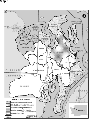
(3) The following portion of WRIA 17 located in Clallam County, as shown in Map B in WAC 173-517-070, will be addressed through future rule making and is excluded from coverage under this chapter:
• Johnson Creek;
• West Sequim Bay;
• Dean Creek;
• Jimmycomelately Creek;
• Chicken Coop Creek; and
• The portion of Miller Peninsula in Clallam County.
(4) This chapter shall not affect existing water rights, including perfected riparian rights, or other appropriative rights, existing on the effective date of this chapter, unless otherwise provided for in the conditions of the water right in question.
(5) This chapter shall not affect federal or Indian reserved rights. The Jamestown S'Klallam, Port Gamble S'Klallam, Lower Elwha Klallam, and Skokomish Tribes reserve the right to claim a treaty-derived off-reservation instream flow right with senior priority. The extent of such rights can only be determined in other forums outside of this chapter.
(6) This chapter does not limit ecology's authority to establish flow requirements or conditions under other laws, including hydropower licensing under RCW 90.48.260.
[]
(1) "Allocation" means the designating of specific amounts of water.
(2) "Appropriation" means the process of legally acquiring the right to specific amounts of water for beneficial uses, as consistent with ground and surface water codes and other applicable statutes. This term refers to both surface and ground water right permits and to ground water withdrawals exempted from permit requirements under RCW 90.44.050.
(3) "Commercial agriculture" means the production of crops for sale, crops intended for widespread distribution (e.g., markets), and nonfood crops such as hay and lavender. Commercial agriculture includes livestock production and livestock grazing. Commercial agriculture does not include crops grown for household consumption (e.g., household vegetable gardens or fruit trees).
(4) "Consumptive use" means a beneficial use of water that diminishes the amount or quality of water in the water source.
(5) "Domestic use" means use of water associated with human health and welfare requirements, including water used for drinking, bathing, sanitary requirements, cooking, laundering and other incidental household uses, including potable domestic water requirements associated with commercial and industrial purposes.
(6) "Ecology" means the Washington state department of ecology.
(7) "Group domestic system" means domestic use of the ground water exemption for two or more residences.
(8) "Hydraulically connected" means saturated conditions exist that allow water to move between two or more sources of water, either between surface water and ground water or two ground water sources.
(9) "Individual user" means all uses on an individual parcel or adjoining parcels under common ownership that do not qualify as a group domestic system.
(10) "Instream flow" means a stream flow level set in rule to protect and preserve wildlife, fish, scenic, aesthetic, recreation, water quality and other environmental values, and navigational values. The term "instream flow" means a base flow under chapter 90.54 RCW, a minimum flow under chapter 90.03 or 90.22 RCW, or a minimum instream flow under chapter 90.82 RCW.
(11) "Interruptible use" means a use, authorized under a water right, which must cease diversion or withdrawal when stream flows fall below the instream flow levels established in this rule.
(12) "Mitigation plan" means a plan, submitted to and approved by ecology, to offset the impacts of a proposed consumptive use. A mitigation plan may address impacts to a stream, basin, reach, or other area, for an individual withdrawal or for multiple withdrawals in a subbasin.
(a) A mitigation plan must show that the proposed withdrawal with mitigation in place, will not:
• Impair existing water rights, including instream flow rights;
• Be detrimental to the public interest; or
• Consume water from a closed source.
(b) The plan must include financial assurance, ensure mitigation measures for the duration of the water use and prohibit water provided for the purpose of mitigation from appropriation for any other purpose.
(c) The plan must include a monitoring and reporting plan, including a quality assurance/quality control plan.
(13) "Outdoor irrigation" means watering greenhouse or outdoor plants, lawns, or gardens.
(14) "Permit-exempt withdrawals" or "permit-exempt well" means a ground water withdrawal exempted from permit requirements under RCW 90.44.050, but otherwise subject to the surface and ground water statutes and other applicable laws, including this chapter.
(15) "Reserve" means a one-time, finite allocation of water for future appropriations.
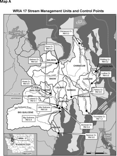
(16) "Stream management unit" means a stream segment, reach, or tributary used to describe the part of the relevant stream to which a particular instream flow level applies.
(17) "Subbasin" means a reserve management area or coastal management area as shown on Map B in WAC 173-517-070.
(18) "Withdrawal" means the appropriation or use of ground water, or the diversion or use of surface water. Withdrawal includes both withdrawals under a water right permit and permit-exempt withdrawals.
[]
(2) When ecology determines that a violation has occurred, it shall:
(a) First attempt to achieve voluntary compliance. One method is to offer information and technical assistance to the person, in writing, showing one or more means to legally accomplish the person's purposes.
(b) If education and technical assistance do not achieve compliance, ecology may issue a notice of violation, a formal administrative order under RCW 43.27A.190, or assess penalties under RCW 43.83B.336, 90.03.400, 90.03.410, 90.03.600, 90.44.120, and 90.44.130.
(3) Nothing in this section is intended to prevent ecology from taking immediate action to cause a violation to be ceased immediately if in the opinion of the department the nature of the violation is causing harm to other water rights or to public or tribal resources.
[]
[]
(2) Ecology, in consultation with the counties, the city of Port Townsend, Jefferson County PUD #1, tribal governments, other state agencies, and the WRIA 17 planning unit (if active), may initiate a review, and if necessary a modification through rule making, of this chapter as appropriate, including whenever:
• Applicable statutory changes are enacted.
• Significant new information becomes available.
• Significant changes in conditions such as population growth trends, water service areas and ground water levels occur.
• It appears that the collection and use of rainwater is causing impairment or adverse impacts to instream flows or existing water rights.
(3) Ecology, in consultation with the counties, Jefferson County PUD #1, tribal governments and the WRIA 17 planning unit (if active), will regularly review the allocated and unallocated amounts for each reserve management area.
[]
|
 |
 |
[]
PART B - INSTREAM FLOWS AND CLOSURES
Table 1
Stream Management Unit Information
| Stream Management Unit Name | Control Point by
River Mile (RM); Latitude North (Lat) and Longitude West (Long) |
Stream Management Reach |
| Big Quilcene River | RM 0.4 Lat 47° 49' 07" N, Long 122° 52' 17" W |
From mouth to headwaters, including tributaries. |
| Chimacum Creek | RM 0.3 Lat 48° 03' 00" N, Long 122° 47' 07" W |
From mouth to headwaters, including tributaries. |
| Donovan Creek | RM 0.4 Lat 47° 49' 58" N, Long 122° 51' 43" W |
From mouth to headwaters, including tributaries. |
| Howe Creek | RM 0.5 Lat 47° 52' 43" N, Long 122° 55' 24" W |
From mouth to headwaters, including tributaries. |
| Leland Creek | RM 0.1 Lat 47° 50' 18" N, Long 122° 53' 10" W |
From mouth to headwaters, including tributaries. |
| Little Quilcene River | RM 0.8 Lat 47° 49' 48" N, Long 122° 52' 30" W |
From mouth to headwaters, including tributaries except Leland and Howe creeks. |
| Ludlow Creek | RM 0.5 Lat 47° 55' 00" N, Long 122° 43' 00" W |
From mouth to headwaters, including tributaries. |
| Piddling Creek #17.0200 | RM 0.2 Lat 47° 57' 27" N, Long 122° 41' 54" W |
From mouth to headwaters, including tributaries. |
| Salmon Creek | RM 0.8 Lat 47° 58' 49" N, Long 122° 53' 49" W |
From mouth to headwaters, including tributaries. |
| Snow Creek | RM 0.4 Lat 47° 59' 02" N, Long 122° 53' 12" W |
From mouth to headwaters, including tributaries. |
| Spencer Creek | RM 0.0 Lat 47° 44' 45" N, Long 122° 52' 33" W |
From mouth to headwaters, including tributaries. |
| Tarboo Creek | RM 0.8 Lat 47° 52' 08" N, Long 122° 49' 03" W |
From mouth to headwaters, including tributaries. |
| Thorndyke Creek | RM 1.2 Lat 47° 49' 24" N, Long 122° 44' 23" W |
From mouth to headwaters, including tributaries. |
[]
(2) Instream flows established in this chapter are water rights, which protect instream values from future consumptive appropriations. The priority date of the instream flows is the effective date of this chapter.
(3) Instream flows will be protected from impairment by any new water rights commenced after the effective date of this chapter and by all future changes and transfers of senior and junior water rights, including both surface and ground water rights. The following water rights are not subject to instream flows:
(a) Water rights existing on the effective date of this chapter as explained in WAC 173-517-020(4).
(b) Water rights appropriated from the reserves of water established in WAC 173-517-150.
(c) Future withdrawals for environmental restoration purposes under WAC 173-517-200, unless included as a permit condition.
(4) Instream flows are expressed in cubic feet per second (cfs), and measured at the control points identified in WAC 173-517-080.
(5) Instream flows are established in Tables 2 through 4 below, for the stream management units identified in WAC 173-517-080.
Table 2
Instream Flows (in cfs) for Big and Little Quilcene Rivers,
with Ecology Gauge Number and River Mile (RM)
| Month | Big Quilcene River Ecology Gauge #17A060 RM 0.4 | Little Quilcene River Ecology Gauge #17D060 RM 0.8 | ||
| January | 120 | 61 | ||
| February | 120 | 61 | ||
| March | 190 | 100 | ||
| April | 190 | 100 | ||
| May | 190 | 92 | ||
| June | 190 | 66 | ||
| July | 190 | 66 | ||
| August | 167 | 27 | ||
| September | 94 | 30 | ||
| October | 180 | 48 | ||
| November | 120 | 61 | ||
| December | 120 | 61 | ||
Table 3
Instream Flows (in cfs) for Named Creeks with Ecology Stream Gauges
(including gauge number and River Mile (RM))
| Month | Chimacum
Creek Ecology
Gauge #17B050 RM 0.3 |
Salmon Creek
Ecology Gauge
#17F060 RM 0.8 |
Snow Creek
Ecology Gauge
#17E060 RM 0.4 |
Tarboo Creek
Ecology Gauge
#17G060 RM 0.8 |
Thorndyke
Creek Ecology
Gauge #17H060 RM 1.2 |
|||||
| January | 25 | 21 | 35 | 20 | 24 | |||||
| February | 25 | 21 | 35 | 20 | 24 | |||||
| March | 46 | 40 | 50 | 25 | 45 | |||||
| April | 46 | 35 | 50 | 16 | 45 | |||||
| May | 32 | 26 | 50 | 8 | 30 | |||||
| June | 10 | 26 | 35 | 8 | 30 | |||||
| July | 10 | 9 | 17 | 8 | 12 | |||||
| August | 10 | 9 | 15 | 8 | 12 | |||||
| September | 17 | 9 | 20 | 8 | 12 | |||||
| October | 20 | 12 | 35 | 8 | 12 | |||||
| November | 25 | 21 | 35 | 20 | 24 | |||||
| December | 25 | 21 | 35 | 20 | 24 | |||||
Table 4
Instream Flows (in cfs) for Other Named Creeks (including River Mile (RM))
| Month | Donovan
Creek RM 0.4 |
Howe Creek RM 0.5 |
Leland
Creek RM 0.1 |
Ludlow
Creek RM 0.5 |
Piddling
Creek RM 0.2 |
Spencer
Creek RM 0.0 |
||||||
| January | 15.5 | 17.1 | 33.1 | 32.1 | 5.8 | 13.3 | ||||||
| February | 10.2 | 11.3 | 21.8 | 21.2 | 3.8 | 8.8 | ||||||
| March | 29.8 | 32.6 | 58.3 | 56.8 | 12.4 | 26.1 | ||||||
| April | 29.8 | 32.6 | 58.3 | 56.8 | 12.4 | 26.1 | ||||||
| May | 19.7 | 21.5 | 38.5 | 37.9 | 8.2 | 17.2 | ||||||
| June | 19.7 | 21.5 | 38.5 | 37.9 | 8.2 | 17.2 | ||||||
| July | 6.1 | 6.8 | 13.9 | 13.5 | 2.1 | 5.2 | ||||||
| August | 6.1 | 6.8 | 13.9 | 13.5 | 2.1 | 5.2 | ||||||
| September | 6.1 | 6.8 | 13.9 | 13.5 | 2.1 | 5.2 | ||||||
| October | 6.1 | 6.8 | 13.9 | 13.5 | 2.1 | 5.2 | ||||||
| November | 15.5 | 17.1 | 33.1 | 32.1 | 5.8 | 13.3 | ||||||
| December | 15.5 | 17.1 | 33.1 | 32.1 | 5.8 | 13.3 | ||||||
[]
Ecology finds that there is some water available above the instream flows at specific locations and times of year in the Big Quilcene River and Chimacum Creek that could be appropriated for storage or other projects that do not require year-round water supplies. These withdrawals require a water right permit from ecology and are subject to the seasonal restrictions in Table 5, the instream flows established in WAC 173-517-090, and the allocation limits defined in WAC 173-517-140.
(2) Based on small stream size and the need to protect instream values, all streams within coastal management areas designated in WAC 173-517-130 are closed to new surface water withdrawals.
(3) Closures in subsections (1) and (2) of this section include future withdrawals from ground water that would have an adverse impact on closed surface water, including permit-exempt withdrawals.
(4) Exceptions to the closures are provided in WAC 173-517-110.
Table 5
Surface Water Closures
| Stream Management Unit Name | Affected Reach | Timing |
| Big Quilcene River | From mouth to headwaters, including tributaries. | June 16 to November 15 |
| Chimacum Creek | From mouth to headwaters, including tributaries. | March 1 to November 30 |
| Donovan Creek | From mouth to headwaters, including tributaries. | All Year |
| Howe Creek | From mouth to headwaters, including tributaries. | All Year |
| Leland Creek | From mouth to headwaters, including tributaries. | All Year |
| Little Quilcene River | From mouth to headwaters, including tributaries except Leland and Howe creeks. | All Year |
| Ludlow Creek | From mouth to headwaters, including tributaries. | All Year |
| Piddling Creek #17.0200 | From mouth to headwaters, including tributaries. | All Year |
| Salmon Creek | From mouth to headwaters, including tributaries. | All Year |
| Snow Creek | From mouth to headwaters, including tributaries. | All Year |
| Spencer Creek | From mouth to headwaters, including tributaries. | All Year |
| Tarboo Creek | From mouth to headwaters, including tributaries. | All Year |
| Thorndyke Creek | From mouth to headwaters, including tributaries. | All Year |
[]
PART C - FUTURE NEW WATER USE(1) The proposed use is nonconsumptive.
(2) The proposed surface water appropriation would not have an adverse effect on any of the surface waters closed in WAC 173-517-100 (1) and (2).
(3) The proposed ground water withdrawal is located where it would not adversely affect any of the surface waters closed in WAC 173-517-100 (1) and (2), by meeting either condition (a) or (b) of this subsection:
(a) The person or entity seeking to commence a proposed ground water appropriation shows, through scientifically sound studies and technical analysis, that the ground water use would not have an adverse effect on any of the surface waters closed in WAC 173-517-100 (1) and (2), and receives approval of a water right.
(b) The proposed ground water appropriation occurs in a coastal management area designated in WAC 173-517-130, and meets the criteria in that section.
(4) The person or entity seeking to commence the new appropriation chooses to submit a mitigation plan as defined in WAC 173-517-030(12), and such plan is approved by ecology. If monitoring shows the mitigation is not effective, use of water under the appropriation shall then be subject to the instream flows. In the case of a closed basin, the use shall cease until an effective mitigation plan is put in place.
(5) The proposed water appropriation qualifies as an interruptible use and meets the criteria in WAC 173-517-140.
(6) The proposed water appropriation qualifies for the reserves established and conditioned in WAC 173-517-150.
(7) The proposed water appropriation is for an environmental restoration project and meets the criteria in WAC 173-517-200.
(8) The proposed use relies on rainwater collected from the rooftop of a structure that serves another primary purpose (such as a house or barn) and all of the following criteria are met:
(a) The water is collected in barrels, cisterns, or lined impoundments that do not allow mixing with water from unauthorized sources;
(b) The water is used on site; and
(c) The usage is consistent with state and county health and storm water requirements. Ecology reserves the right to regulate water collected from rooftops under applicable laws.
[]
(1) For the purposes of this chapter the conservation standard for permit-exempt withdrawals is defined as follows:
(a) Water use from a permit-exempt well must be consistent with Jefferson County or Clallam County code, as applicable, and other applicable laws, including the statute on permit exemptions, RCW 90.44.050.
(b) A permit-exempt well serving an individual user shall not exceed a maximum of 500 gpd or an annual average more than 350 gpd, for all permit-exempt uses authorized under RCW 90.44.050.
(c) A well serving a group domestic system shall not exceed a maximum use of 500 gpd or an annual average more than 350 gpd, for each residence, and shall not exceed a total use of 5,000 gpd for the group. The design and construction of group domestic systems must be consistent with applicable state department of health requirements and applicable Jefferson County or Clallam County requirements.
(2) New permit-exempt well use exceeding 500 gpd for an individual use may occur provided all of the following are met:
(a) Water use greater than 500 gpd must be offset through implementation of an approved mitigation plan as described in WAC 173-517-030(12). If monitoring of a mitigation plan shows the mitigation is not effective, departmental approval of the mitigation plan shall be suspended and the water use shall cease until the department approves a new or revised mitigation plan; and
(b) Total water use shall not exceed 5,000 gpd.
(3) New permit-exempt withdrawals must measure water use in accordance with WAC 173-517-180.
[]
(2) Therefore ecology designates coastal management areas and establishes limits on future ground water withdrawals and well construction in those areas. The boundaries of these areas are shown on Map B in WAC 173-517-070. Table 6 lists the areas.
(3) Future ground water withdrawals from designated coastal management areas shall be subject to the following limits:
(a) Except for areas served by the city of Port Townsend water supply, future permit-exempt well use may not occur where connection to a public water supplier can be provided in a timely and reasonable manner. Determinations of what it means to provide water service in a timely and reasonable manner shall be consistent with public water system plans if applicable, and applicable state and local laws including, but not limited to, Jefferson County code;
(b) New water use from a permit-exempt well must be consistent with Jefferson County code and other applicable laws;
(c) New water use from a permit-exempt well is limited to the conservation standard defined in WAC 173-517-120, except as allowed in subsection (d) of this section; and
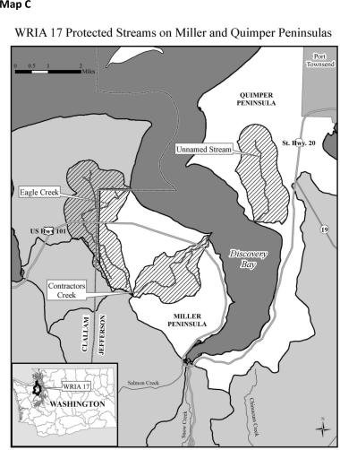
(d) In the Miller Peninsula and Quimper Peninsula designated coastal management areas, expanded permit-exempt well use up to 5,000 gpd for an industrial purpose consisting of commercial agricultural use is allowed if the withdrawal is located outside of three designated watersheds including: Contractors Creek and Eagle Creek on Miller Peninsula and an unnamed stream on Quimper Peninsula (#0215 Admiralty Inlet drainage), as shown on Map C in WAC 173-517-070. Such users must register with ecology or its designee. If the commercial agricultural use should cease, then water use must be limited to the conservation standard defined in WAC 173-517-120.
Table 6
Designated Coastal Management Areas
| Bolton Peninsula |
| Devil's Lake |
| Marple |
| Miller Peninsula (Jefferson) |
| Oak Bay/Mats Mats Bay |
| Quimper Peninsula |
| Squamish Harbor |
| Toandos Peninsula |
| All islands, including Marrowstone and Indian islands |
[]
(2) A person or entity seeking a new interruptible appropriation must provide assurances that any negative effects on surface water that may result from withdrawals will be limited to the above locations and times.
(3) In no case shall total cumulative appropriations exceed the allocation limit specified in Table 7 for each river. However, ecology may lower these allocation limits on a case-by-case basis, upon consultation with the state department of fish and wildlife and tribes, whenever more protection of habitat-forming functions is needed.
(4) Interruptible uses must not impair existing water rights and instream flows set in WAC 173-517-090.
Table 7
Open Period and Allocation Limit
| Water Source | Open Period | Allocation Limit in Cubic Feet Per Second (cfs) and Gallons Per Day (gpd) |
| Big Quilcene River | Open Period: November 16 to June 15 | Allocation Limit: 15 cfs; 9.69 million gpd |
| Chimacum Creek | Open Period: December 1 to February 29 | Allocation Limit: 3 cfs; 1.94 million gpd |
[]
Based on this finding, ecology hereby allocates an amount of water for each reserve management area as indicated in Table 8. These reserves of water are not subject to the instream flows established in WAC 173-517-090 or closures established in WAC 173-517-100. The priority date of an appropriation from a reserve is the effective date of this chapter.
These reserves are available to a user only if the conditions set forth in this section are met, as well as any applicable requirements of law, including, but not limited to, all water resource laws and regulations.
(2) These reserves shall be available for use only after the county with jurisdiction commits to ecology in writing confirming that determinations of adequate potable water for building permits and subdivision approvals will be consistent with this chapter.
(3) Permit-exempt well withdrawals from reserves may not occur where a public water supplier can provide a connection in a timely and reasonable manner. Determinations of what it means to provide water service in a timely and reasonable manner shall be consistent with public water system plans, if applicable, and applicable state and local laws including, but not limited to, Jefferson County or Clallam County code.
(4) Withdrawals from the reserves of water in Donovan, Ludlow, Piddling, Spencer, and Tarboo reserve management areas shall be limited to permit-exempt well use consistent with the conservation standard defined in WAC 173-517-120.
(5) Withdrawals from the reserves of water in Salmon and Snow reserve management areas shall be limited to permit-exempt well use consistent with the conservation standard defined in WAC 173-517-120, or the following: Up to 5,000 gallons per day of the Salmon Creek reserve, and up to 3,000 gallons per day of the Snow Creek reserve may be used for a permit-exempt withdrawal for commercial agriculture.
(a) Each user must register with ecology or its designee before water use for commercial irrigation begins.
(b) If the commercial agricultural use ceases, then the balance of the water returns to the reserve and use of the well shall be consistent with the conservation standard defined in WAC 173-517-120.
(6) Withdrawals from the reserves of water in Little Quilcene (includes Leland and Howe creeks), and Thorndyke reserve management areas shall be limited to permit-exempt well use consistent with the conservation standard defined in WAC 173-517-120, or the uses listed below through approval of a water right permit subject to a public interest evaluation that takes into account water availability for future domestic use in the subbasin:
(a) Municipal or community domestic water supply with domestic hookups consistent with the conservation standard defined in WAC 173-517-120.
(b) Agricultural irrigation.
(c) Industrial.
(7) Withdrawals from the reserve of water in the Big Quilcene reserve management area shall be limited to permit-exempt well use consistent with the conservation standard defined in WAC 173-517-120, or the following:
(a) Permit exempt withdrawal for commercial agriculture.
(i) Each user is limited to 5,000 gpd as a permit-exempt well under RCW 90.44.050.
(ii) Each user must register with ecology or its designee before water use for commercial irrigation begins.
(iii) If the commercial agricultural use ceases, then the balance of the water returns to the reserve and use of the well shall be consistent with the conservation standard defined in WAC 173-517-120.
(b) The uses listed below through approval of a water right permit subject to a public interest evaluation that takes into account water availability for future domestic use in the subbasin:
(i) Municipal or community domestic water supply with domestic hookups consistent with the conservation standard defined in WAC 173-517-120.
(ii) Agricultural irrigation.
(iii) Industrial.
(8) Future withdrawals from the reserve of water in the Chimacum reserve management area shall be limited to domestic permit-exempt well use, and such use shall not include outdoor irrigation, except for the following:
(a) When alternative water supply or a mitigation strategy is approved by ecology and implemented, this restriction on outdoor irrigation for the Chimacum basin no longer applies and permit-exempt well use consistent with the conservation standard defined in WAC 173-517-120 is allowed.
(b) If the report for U.S. Geological Survey ground water model currently under construction for the Chimacum Creek subbasin identifies specific areas where new well pumping will not have any effect on creek flows, withdrawals from new wells in those areas will not be deducted from the reserve and will not be subject to the restriction on outdoor irrigation. Instead, use of new permit-exempt wells will be regulated by the statutory permit exemption found in RCW 90.44.050. If such a change occurs, ecology shall notify the public of these findings through publication of a Chimacum Creek Water Supply Bulletin.
(9) The place of use of water taken from the reserve is limited to the reserve management area from which it is withdrawn unless ecology, in consultation with the applicable county, department of fish and wildlife, and the tribes allows specific transfers between subbasins. An applicant for a water right that includes out of subbasin water use must comply with WAC 173-517-210.
(10) When each reserve is fully appropriated, the applicable reserve management areas are hereby closed to any further consumptive appropriation. Under such circumstances water for new uses may be available if:
• Mitigation is provided;
• The use is nonconsumptive;
• Alternative sources of water are available; or
• An existing water right can be changed or transferred.
Table 8
Reserve Management Areas, Reserve Quantities and Allowed Uses
| Reserve Management Area Water Source (including tributaries) | Reserve Quantity Maximum Average Daily Use in Gallons (gpd) | Allowed Uses of Reserve* | |
| Big Quilcene | 200,400 gpd | • Permit-exempt uses under the conservation standard per WAC 173-517-120 | |
| • Permit-exempt withdrawals for agriculture | |||
| • Water right permits subject to public interest test for domestic availability | |||
| Chimacum | 1,940 gpd | • Permit-exempt withdrawals for domestic use, no outdoor irrigation | |
| Donovan | 2,326 gpd | • Permit-exempt uses under the conservation standard per WAC 173-517-120 | |
| Little Quilcene (includes Leland and Howe creeks) | 38,800 gpd | • Permit-exempt uses under the conservation standard per WAC 173-517-120 | |
| • Water right permits subject to public interest test for domestic availability | |||
| Ludlow | 7,830 gpd | • Permit-exempt uses under the conservation standard per WAC 173-517-120 | |
| Piddling | 1,845 gpd | • Permit-exempt uses under the conservation standard per WAC 173-517-120 | |
| Salmon | 9,050 gpd | • Permit-exempt uses under the conservation standard per WAC 173-517-120 | |
| • Permit-exempt withdrawals for agriculture | |||
| Snow | 4,140 gpd | • Permit-exempt uses under the conservation standard per WAC 173-517-120 | |
| • Permit-exempt withdrawals for agriculture | |||
| Spencer | 2,200 gpd | • Permit-exempt uses under the conservation standard per WAC 173-517-120 | |
| Tarboo | 7,110 gpd | • Permit-exempt uses under the conservation standard per WAC 173-517-120 | |
| Thorndyke | 31,670 gpd | • Permit-exempt uses under the conservation standard per WAC 173-517-120 | |
| • Water right permits subject to public interest test for domestic availability | |||
| *This table lists the types of allowed uses. See the text of the rule for specific requirements for each use. |
[]
(2) For an appropriation under a permit, ecology will account for water use under the reserve based on authorized quantities under water right permits or certificates, and metering data.
(3) For permit-exempt ground water appropriations from reserves other than Chimacum subbasin, ecology will deduct a standard amount of 250 gpd for each single domestic use. For a permit-exempt agricultural use, ecology will deduct 5,000 gpd for the Big Quilcene and Salmon Creek subbasins and 3,000 gpd for the Snow Creek subbasin. The amounts deducted from the reserves may be adjusted periodically by ecology, to reflect actual use during low flow conditions based on metering data or other measurements.
(4) For permit-exempt ground water appropriations from the Chimacum reserve, ecology will deduct a standard amount of 13 gpd for each single domestic use.
(5) If a water user permanently ceases use of water from a reserve, ecology may credit the water back to the appropriate reserve, upon demonstration, through written certification, that the well or surface water diversion has been decommissioned.
(6) Ecology shall notify the county (or counties) with jurisdiction when it determines that fifty percent, seventy-five percent, and one hundred percent, respectively, of a reserve is appropriated.
(7) If a new appropriation, located in a subbasin with a reserve, is fully offset through implementation of an approved mitigation plan as described in WAC 173-517-030(12), then ecology will not deduct the amount of new water use from the reserve.
[]
Any withdrawal from a lake or pond in WRIA 17 requires a water right permit from ecology, and must be consistent with the provisions of this chapter.
[]
[]
(a) If a float or demand type valve is not used, the tank overflow must return to the same source, at or near the point of diversion.
(b) The stock tank must serve no greater number of stock than historically range that parcel of property. The quantity consumed from the stock tank should not exceed the quantity consumed if the stock drank directly from the stream.
(c) Stock water tanks shall be located close to the surface water source, and have as short a bypass reach as possible, not more than is necessary to provide gravity flow.
(d) The purpose in modifying an existing direct access to the stream by stock must be to afford protection to the water body, stream bank, and associated vegetative zone.
(2) The decision to divert stock water from the stream and into a tank does not constitute an adjudication of any claim to the right to the use of the water as between the claimant and the state, or as between one or more water use claimants and another or others.
[]
(1) Ecology may approve a future withdrawal for an ERP only if it meets all the following:
(a) The proposed water use is for a bypass flow for salmonid habitat restoration, or for riparian planting, and the primary purpose of the project is restoration of salmonids;
(b) The proposed project will result in aquatic habitat benefits, and such benefits will exceed any detriment to aquatic habitat that may be caused by reductions in flow at specific locations and times of withdrawal; and
(c) The proposed use qualifies for a temporary permit.
(2) Ecology, in consultation with the department of fish and wildlife and tribes, will evaluate proposed ERPs. ERPs approved by ecology are not subject to closures or instream flows set in this chapter, unless otherwise conditioned by the permit.
[]
(2) An applicant for a water right that includes out of subbasin water use shall:
(a) Provide the public an opportunity to review and comment on the proposed application. The applicant shall:
• Advertise and convene a public meeting to explain the proposal; and
• Allow for public comment on the potential for the proposed use to be harmful to the public interest.
(b) The applicant shall provide ecology a report which identifies:
• Alternatives examined;
• Any alternatives/modifications that the applicant has rejected and why; and
• Any alternatives/modifications that the applicant accepts and, if relevant, have been made.
(c) The report in (b) of this subsection shall also summarize the comments received through the public meeting in (a) of this subsection on the potential for the proposed use to be harmful to the public interest.
[]