WSR 18-03-145
PROPOSED RULES
DEPARTMENT OF
FISH AND WILDLIFE
[Filed January 22, 2018, 12:19 p.m.]
Original Notice.
Preproposal statement of inquiry was filed as WSR 17-20-109 on October 4, 2017.
Title of Rule and Other Identifying Information: Amendments to chapter 220-660 WAC, Hydraulic code rules.
Hearing Location(s): On March 16-17, 2018, at 8:00 a.m., at North Wenatchee Avenue, Wenatchee, Washington 98801.
Date of Intended Adoption: April 20, 2018.
Submit Written Comments to: Randi Thurston, P.O. Box 43234, Olympia, WA 98504-3234, email HPARules@dfw.wa.gov, fax 360-902-2946, by March 17, 2018.
Assistance for Persons with Disabilities: Contact Delores Noyes, phone 360-902-2349, TTY 360-902-2207, email Delores.Noyes@dfw.wa.gov, by March 17, 2018.
Purpose of the Proposal and Its Anticipated Effects, Including Any Changes in Existing Rules: The Washington department of fish and wildlife (WDFW) proposes to amend sections in chapter 220-660 WAC, Hydraulic code rules. These rules regulate aspects of construction projects in state waters for the protection of fish life. The purpose of this rule making is to incorporate statutory changes, accommodate other changed conditions to protect fish life, or respond to requests by customers and other interested parties for improved clarity.
WDFW's primary objective for initiating rule making at this time is to adopt emergency rule (WSR 17-22-013) modifying authorized work times under WAC 220-660-300 for the Sultan River as a permanent rule.
Other subjects WDFW has identified for rule making include the following:
• | Consistency with chapter 77.55 RCW with respect to the curtailment of application fees (WAC 220-660-050); |
• | Ensure authorized work times in WAC 220-660-300 are based on the best available science; |
• | Update the department's mailing address published in WAC 220-660-460 and 220-660-470; and |
• | Make other essential changes to WAC 220-660-050 and 220-660-300 that clarify language or accommodate administrative changes. |
The rule making as proposed will amend the following sections:
WAC 220-660-050 Procedures, 220-660-300 Mineral prospecting, 220-660-460 Informal appeals, and 220-660-470 Formal appeals.
Hydraulic code rules in chapter 220-660 WAC are significant legislative rules under RCW 34.05.328.
Note that a proposal for changes to authorized work times in WAC 220-660-300(7) for the Lower Columbia River mainstem were removed from this package after the preproposal statement of inquiry (CR-101) and before prefiling outreach occurred because the proposal requires additional technical development and stakeholder collaboration.
Reasons Supporting Proposal: WDFW's primary objective for initiating rule making at this time is to adopt an emergency rule (WSR 17-14-079) as a permanent rule, modifying authorized work times under WAC 220-660-300(7) for the Sultan River.
Other objectives WDFW has identified for this rule-making activity include the following:
• | Provide consistency with chapter 77.55 RCW regarding the curtailment of application fees (WAC 220-660-050); |
• | Ensure authorized work times in WAC 220-660-300(7) are based on the best available science; |
• | Update the department's mailing address published in WAC 220-660-460 and 220-660-470; and |
• | Make other changes to 220-660-050 and 220-660-300 that clarify language or accommodate administrative changes without changing the intent of the rules. |
WDFW extensively analyzed proposed rule changes prior to filing a preproposal statement of inquiry. We considered goals and objectives of the authorizing statutes as well as objectives for rule making at this particular time. Throughout development of the proposed rule changes, and as part of prefiling outreach, WDFW considered alternatives to rule making as well as alternative rule language for each element determined to require amendment. Elements that did not meet the specific objectives for this rule-making activity or for which alternatives could be found, were placed on hold and not included in this CR-102 package of proposed rule changes. WDFW anticipates future rule change activities will occur until all the modifications initially identified by the department as necessary can be brought through the rule-making process. We think this is a more efficient and less burdensome approach than waiting to conduct an overhaul of all the hydraulic code rules at once, as was necessary back in 2014.
After considering all these aspects of the decision to propose rule amendments, WDFW determined that the proposed rule represents the minimum set of rule changes required to meet rule-making objectives at this time.
Statutory Authority for Adoption: RCW 77.04.012, directs the department to preserve, protect, perpetuate, and manage fish life.
RCW 77.04.020 grants the fish and wildlife commission the authority to delegate to the director any of the powers and duties vested in the commission.
RCW 77.12.047 grants the fish and wildlife commission authority to adopt, amend, or repeal rules necessary to carry out Title 77 RCW.
RCW 77.55.021 charges WDFW with approving the adequacy of means proposed for protection of fish life in association with the construction of a hydraulic project and authorizes formal and informal appeals.
RCW 77.55.091 prescribes that WDFW establish rules for small scale prospecting and mining.
RCW 77.55.051 and [77.55.]081 authorize the removal or control of aquatic noxious weeks [weeds] through rules published in a pamphlet format.
RCW 34.05.350 compels the department to actively undertake procedures to adopt emergency rules as permanent.
Statute Being Implemented: Chapter 77.55 RCW, Construction projects in state waters.
Rule is not necessitated by federal law, federal or state court decision.
Name of Proponent: WDFW, habitat program, protection division, governmental.
Name of Agency Personnel Responsible for Drafting: Teresa Scott, 1111 Washington Street, Olympia, WA 98501, 360-902-2713; Implementation: Randi Thurston, 1111 Washington Street, Olympia, WA 98501, 360-902-2602; and Enforcement: Chief Steve Bear, 1111 Washington Street, Olympia, WA 98501, 360-902-2373.
A school district fiscal impact statement is not required under RCW 28A.305.135.
A cost-benefit analysis is required under RCW 34.05.328. A preliminary cost-benefit analysis may be obtained by contacting Randi Thurston, P.O. Box 43234, Olympia, WA 98504-3234, phone 360-902-2602, fax 360-902-2946, TTY 360-902-2207, email HPARules@dfw.wa.gov, hydraulic project approval (HPA) rule-making web site http://wdfw.wa.gov/licensing/hpa/rulemaking/.
The preliminary cost-benefit analysis is contained in the 2018 hydraulic code rule change proposals - preliminary regulatory analyses document that also contains the least burdensome alternative analysis, Regulatory Fairness Act compliance discussion, and significant legislative rule procedural requirements. This document is available at the HPA rule-making web site http://wdfw.wa.gov/licensing/hpa/rulemaking/.
This rule proposal, or portions of the proposal, is exempt from requirements of the Regulatory Fairness Act because the proposal:
Is exempt under RCW 19.85.025(3) as the rules relate only to internal governmental operations that are not subject to violation by a nongovernment party; rules only correct typographical errors, make address or name changes, or clarify language of a rule without changing its effect; rules set or adjust fees under the authority of RCW 19.02.075 or that set or adjust fees or rates pursuant to legislative standards, including fees set or adjusted under the authority of RCW 19.80.045; and rules adopt, amend, or repeal a procedure, practice, or requirement relating to agency hearings; or a filing or related process requirement for applying to an agency for a license or permit.
Is exempt under RCW 19.85.025(4).
Explanation of exemptions: Proposed rule does not affect small businesses.
January 22, 2018
Scott Bird
Rules Coordinator
AMENDATORY SECTION (Amending WSR 15-02-029, filed 12/30/14, effective 7/1/15)
WAC 220-660-050 Procedures—Hydraulic project approvals.
(1) Description:
(a) There are six categories of HPAs: Standard, emergency, imminent danger, chronic danger, expedited, and pamphlet. These categories are discussed in more detail throughout this section. Most HPAs issued by the department are standard HPAs. Guidance for applying for an HPA is provided on the department's web site.
(b) HPAs do not exempt a person from obtaining other necessary permits and following the rules and regulations of local, federal, and other Washington state agencies.
(2) Fish life concerns: Construction and other work activities in or near water bodies can kill or injure fish life directly and can damage or destroy habitat that supports fish life. Damaged or destroyed habitat can continue to cause lost fish life production for as long as the habitat remains altered. HPAs help ensure construction and other work is done in a manner that protects fish life.
(3) Standard HPA:
(a) The department issues a standard HPA when a hydraulic project does not qualify for an emergency, imminent danger, chronic danger, expedited or pamphlet HPA. An individual standard HPA is limited to a single project site. Some special types of standard HPAs may cover multiple project sites.
(b) Special types of standard HPAs:
(i) Fish habitat enhancement project (FHEP) HPA.
(A) Projects must satisfy the requirements in RCW 77.55.181(1) to be processed as a fish habitat enhancement project.
(B) Projects that are compensatory mitigation for a development or other impacting project are not eligible. This includes proposals for mitigation banks or in-lieu fee mitigation proposals. The sole purpose of the project must be for fish habitat enhancement.
(C) The department may reject an FHEP proposed under RCW 77.55.181 if the local government raises concerns during the comment period that impacts from the project cannot be mitigated by conditioning the HPA. The department will reject an FHEP if the department determines that the size and the scale of the project raises public health or safety concerns. If the department rejects a project for streamlined processing, the department must provide written notice to the applicant and local government within forty-five days of receiving the application.
(D) An applicant whose fish habitat enhancement project is rejected may submit a new complete written application with project modifications or additional information required for streamlined processing. An applicant may request that the department consider the project under standard HPA processing procedures by submitting a new complete written application for standard processing.
(ii) Multisite HPA.
(A) A standard HPA may authorize work at multiple project sites if:
(I) All project sites are within the same water resource inventory area (WRIA) or tidal reference area;
(II) The primary hydraulic project is the same at each site so there is little variability in HPA provisions across all sites; and
(III) Work will be conducted at no more than five project sites to ensure department staff has sufficient time to conduct site reviews.
(B) The department may make an exception for projects the department has scoped prior to application submittal or when no prepermit issuance site visits are needed.
(iii) General HPA.
(A) The department may issue general HPAs to government agencies, organizations, or companies to perform the same work in multiple water bodies across a large geographic area.
(B) To qualify for a general HPA, projects must protect fish life:
(I) Technical provisions in the HPA must fully mitigate impacts to fish life;
(II) The projects must be relatively simple so that the HPA provisions are the same across all sites, and can therefore be permitted without site-specific provisions; and
(III) The projects must have little or no variability over time in site conditions or work performed.
(C) The general HPA will include a requirement that notice be given to the department when activities utilizing heavy equipment begin. The department may waive this requirement if the permittee and department meet annually to review scheduled activities for the upcoming year.
(D) The department and the applicant may negotiate the scope and scale of the project types covered. The department and the applicant must agree on the fish protection provisions required before the application is submitted.
(E) The department may reject applications for a general HPA if:
(I) The proposed project does not meet the eligibility requirements described in subsection (3)(b)(iii)(B) of this section; or
(II) The department and the applicant cannot agree on the fish protection provisions.
(F) The department must provide written notice of rejection of a general HPA application to the applicant. The applicant may submit a new complete written application with project modifications or additional information required for department consideration under standard HPA processing procedures.
(iv) "Model" HPA.
(A) The department will establish a "model" HPA application and permitting process for qualifying hydraulic projects. To qualify, an individual project must comply with the technical provisions established in the application. Hydraulic projects that qualify for the model process must:
(I) Fully mitigate impacts to fish life in the technical provisions of the HPA;
(II) Be a low complexity project that minimizes misinterpretation of the HPA provisions allowing the HPA to be permitted without site-specific provisions; and
(III) Meet all of the eligibility requirements described in the model application.
(B) If needed to confirm project eligibility, the department may conduct a site visit before approving or rejecting a model application.
(C) The department may reject applications for model HPAs if:
(I) The plans and specifications for the project are insufficient to show that fish life will be protected; or
(II) The applicant or authorized agent does not fill out the application completely or correctly.
(D) The department must provide written notice of rejection of an application to the applicant. The applicant may submit a new complete written application with project modifications or additional information required for department consideration under standard HPA processing procedures under this section, or may submit a new model application if the department rejected the application because the person did not fill out the original application correctly.
(4) Emergency HPA:
(a) Declaring an emergency.
(i) Authority to declare an emergency, or continue an existing declaration of emergency, is conveyed to the governor, the department, or to a county legislative authority by statute. An emergency declaration may be made when there is an immediate threat to life, the public, property, or of environmental degradation;
(ii) The county legislative authority must notify the department, in writing, if it declares an emergency;
(iii) Emergency declarations made by the department must be documented in writing;
(iv) When an emergency is declared, the department must immediately grant verbal approval upon request for work to protect life or property threatened by waters of the state because of the emergency, including repairing or replacing a stream crossing, removing obstructions, or protecting stream banks. The department may also grant written approval if the applicant agrees.
(b) If the department issues a verbal HPA, the department must follow up with a written HPA documenting the exact provisions of the verbal HPA within thirty days of issuing the verbal HPA.
(c) Compliance with the provisions of chapter 43.21C RCW (State Environmental Policy Act) is not required for emergency HPAs.
(d) The department may require a person to submit an as-built drawing within thirty days after the hydraulic project authorized in the emergency HPA is completed.
(e) Within ninety days after a hydraulic project authorized in an emergency HPA is completed, any remaining impacts must be mitigated or a mitigation plan must be submitted to the department for approval.
(5) Imminent danger HPA:
(a) Authority to declare imminent danger is conveyed to the department or county legislative authority by statute. The county legislative authority must notify the department in writing if it determines that an imminent danger exists.
(b) Imminent danger declarations made by the department must be documented in writing.
(c) When imminent danger exists, the department must issue an expedited HPA upon request for work to remove obstructions, repair existing structures, restore banks, and to protect fish life or property.
(d) When imminent danger exists, and before starting work, a person must submit a complete written application to the department to obtain an imminent danger HPA. Compliance with the provisions of chapter 43.21C RCW (State Environmental Policy Act) is not required for imminent danger HPAs.
(e) Imminent danger HPAs must be issued by the department within fifteen calendar days after receiving a complete written application. Work under an imminent danger HPA must be completed within sixty calendar days of the date the HPA is issued.
(f) Within ninety days after a hydraulic project authorized in an imminent danger HPA is completed, any remaining impacts must be mitigated or a mitigation plan must be submitted to the department for approval.
(6) Chronic danger HPA:
(a) The department must issue a chronic danger HPA upon request for work required to abate the chronic danger. This work may include removing obstructions, repairing existing structures, restoring banks, restoring road or highway access, protecting fish life, or protecting property.
(b) Authority to declare when a chronic danger exists is conveyed to a county legislative authority by statute. A chronic danger is a condition in which any property, except for property located on a marine shoreline, has experienced at least two consecutive years of flooding or erosion that has damaged or has threatened to damage a major structure, water supply system, septic system, or access to any road or highway.
(c) The county legislative authority must notify the department in writing when it determines a chronic danger exists.
(d) When chronic danger is declared, and before starting work, a person must submit a complete written application to the department to obtain a chronic danger HPA. Unless the project also satisfies the requirements for fish habitat enhancement projects identified in RCW 77.55.181 (1)(a)(ii), compliance with the provisions of chapter 43.21C RCW (State Environmental Policy Act) is required. Projects that meet the requirements in RCW 77.55.181 (1)(a)(ii), will be processed under RCW 77.55.181(3), and the provisions of chapter 43.21C RCW will not be required.
(7) Expedited HPA:
(a) The department may issue an expedited HPA when normal processing would result in significant hardship for the applicant or unacceptable environmental damage would occur.
(b) Before starting work, a person must submit a complete written application to the department to obtain an HPA.
(c) Compliance with the provisions of chapter 43.21C RCW (State Environmental Policy Act) is not required for expedited HPAs. The department must issue expedited HPAs within fifteen calendar days after receipt of a complete written application. Work under an expedited HPA must be completed within sixty calendar days of the date the HPA is issued.
(d) Within ninety days after a hydraulic project authorized in an expedited HPA is completed, any remaining impacts must be mitigated or a mitigation plan must be submitted to the department for approval.
(8) Pamphlet HPA:
(a) There are two pamphlet HPAs, Gold and Fish and Aquatic Plants and Fish, that cover the most common types of mineral prospecting and removing or controlling aquatic plants, respectively. A person must follow the provisions in the pamphlet. If a person cannot follow the provisions, or disagrees with any provision, the permittee must apply for a standard HPA before starting the hydraulic project.
(b) A person must review a pamphlet HPA before conducting the authorized hydraulic project.
(c) When a pamphlet HPA is used, the permittee must have the pamphlet HPA on the job site when conducting work and the pamphlet must be immediately available for inspection by the department upon request.
(d) All persons conducting the project must follow all provisions of the pamphlet HPA.
(e) The department may grant exceptions to a pamphlet HPA only if a person applies for a standard individual HPA for the project.
(f) Pamphlet HPAs do not exempt a person from obtaining other appropriate permits and following the rules and regulations of local, federal, and other Washington state agencies.
(9) How to get an HPA:
(a) How to get a pamphlet HPA: A person can download and save or print a pamphlet HPA from the department's web site. A person may also request a pamphlet HPA from the department either verbally or in writing.
(b) How to get an emergency HPA: Upon an emergency declaration, and before starting emergency work, a person must obtain a verbal or written HPA from the department. A complete written application is not required. However, a person must provide adequate information describing the proposed action. Compliance with the provisions of chapter 43.21C RCW (State Environmental Policy Act), is not required for emergency HPAs. A person may request a verbal or written emergency HPA from the biologist who issues HPAs for the geographic area where the emergency is located ((during normal business hours,)) Monday through Friday((,)) from 8:00 a.m. to 5:00 p.m. If the biologist cannot be contacted or it is after business hours, a person must contact the emergency hotline at 360-902-2537 to request an emergency HPA.
(c) How to get a standard, expedited, or chronic danger HPA:
(i) A person must submit a complete written application to the department to obtain an HPA unless the project qualifies for one of the following:
(A) A pamphlet HPA, subsection (3) of this section; or
(B) An emergency HPA, subsection (5) of this section.
(ii) When applying for an HPA, a person must submit one of the following application forms to the department:
(A) The electronic online application developed by the department;
(B) The current version of the JARPA;
(C) The current version of the JARPA including the most recent version of the application for streamlined processing of fish habitat enhancement projects when applying for streamlined processing under RCW 77.55.181. These may be submitted to the department as attachments to the online application form;
(D) The most recent version of the model HPA application or other department-approved alternative applications available from the department's public web site; or
(E) The current version of the JARPA if applying for approval of a watershed restoration project under RCW 77.55.171. This may be submitted to the department as an attachment to the online application form.
(iii) A complete application package for an HPA must contain:
(A) A completed application form signed and dated by the applicant, ((landowner)) landowner(s) or landowner ((representative)) representative(s) of any project site or off-site mitigation location, and the authorized agent, if any. Completing and submitting the application forms through the department's online permitting system is the same as providing signature and date, if all documents required during the online application process are submitted to the department. A copy of an easement granted to the applicant by the landowner that includes an allowance for the department to access the project location(s) and any off-site mitigation location(s) for prepermit or postpermit inspection may be substituted for landowner or landowner representative signature;
(B) Plans for the overall project;
(C) Complete plans and specifications for all aspects of the proposed construction or work waterward of the mean higher high water line in salt water, or waterward of the ordinary high water line in fresh water;
(D) A description of the measures that will be implemented for the protection of fish life, including any reports assessing impacts from the hydraulic project to fish life and habitat that supports fish life, and plans to mitigate those impacts to ensure the project results in no net loss;
(E) For a standard or chronic danger HPA application, a copy of the written notice from the lead agency demonstrating compliance with any applicable requirements of the State Environmental Policy Act under chapter 43.21C RCW, unless otherwise provided for in chapter 77.55 RCW; or the project qualifies for a specific categorical exemption under chapter 197-11 WAC;
(F) Written approval by one of the entities specified in RCW 77.55.181 if the applicant is proposing a fish enhancement project;
(G) ((Payment of the application fee required under chapter 77.55 RCW. This fee must be submitted with the application or paid under a billing agreement established in advance with the department unless the project is one of the following project types that are exempt from the application fee:
(I) Project type approved under pamphlet permits;
(II) Mineral prospecting and mining;
(III) Projects on farm and agricultural land, as defined in RCW 84.34.020;
(IV) Projects reviewed by a department biologist on contract with the applicant; or
(V) Modification of permits issued for projects applied for before July 10, 2012; and
(H) Applicants seeking approval under the farm and agricultural land fee exemption must provide a copy of the county assessor's classification of the property on which the project occurs as farm and agricultural land as that term is defined in RCW 84.34.020.)) For an expedited application, an explanation of why normal processing would result in significant hardship for the applicant or unacceptable environmental damage.
(iv) HPA application submission:
(A) A person must submit the complete application package:
(I) Using the department's online permitting system;
(II) Sending the package via mail to:
Department of Fish and Wildlife
P.O. Box 43234
Olympia, ((Washington)) WA 98504-3234;
(III) Email: HPAapplications@dfw.wa.gov;
(IV) Fax: 360-902-2946;
(V) Uploading to a file transfer protocol site acceptable to the department; or
(VI) ((Hand-delivering)) Hand delivering to the department at 1111 Washington Street S.E., Olympia, WA 98504, Habitat Program, Fifth Floor. The department will not accept applications submitted elsewhere or by other than the applicant or authorized agent.
(B) Dimensions of printed documents submitted with the application package may not be larger than eleven inches by seventeen inches. Pages of documents submitted may not be bound except by paper clips or other temporary fastening.
(C) A person must submit applications and supporting documents with a combined total of thirty or more pages as digital files rather than printed documents. All digital files must be in formats compatible with Microsoft Word, Microsoft Excel, or Microsoft Access programs or in PDF, TIFF, JPEG, or GIF formats.
(D) Applications submitted to the habitat program during normal business hours are deemed received on the date the habitat program receives the application. The department may declare applications received by the habitat program after normal business hours as received on the next business day.
(10) Incomplete applications:
(a) Within ten days of receipt of the application, the department must determine whether an application meets the requirements of this section. If the department determines the application does not meet the requirements, the department will provide written or emailed notification of an incomplete application to the applicant or authorized agent. This written or emailed notification must include a description of information needed to make the application complete. The department may return the incomplete application to the applicant or authorized agent or hold the application on file until it receives the missing information. The department will not begin to process the application until it receives all information needed to complete the application.
(b) The applicant or authorized agent must submit additional information in response to a written notification of incomplete application through the department's online permitting system or to the department's habitat program, Olympia headquarters office. The department will not accept additional information submitted elsewhere or by other than the applicant or authorized agent.
(c) The department may ((not process)) close any application that has been incomplete for more than ((six)) twelve months. The department must provide the applicant or authorized agent with written notification at least one week before closing the application and must provide the option for the applicant or authorized agent to postpone the closure for up to one year. The department must provide the applicant with written notification at the time it closes the application ((expires)). After an application is closed, the applicant or authorized agent must submit a new complete application to receive further consideration of the project.
(11) ((Refund of application fee: The application fee is nonrefundable except when the application fee was paid but the proposed project is not a hydraulic project and therefore does not require an HPA, or the project is exempt from the fee. Upon determination that an application qualifies for a refund, the department must issue the refund within one week.
(12))) Application review period:
(a) Once the department determines an application is complete, the department will provide to tribes and local, state, and federal permitting or authorizing agencies a seven-calendar-day review and comment period. The department will not issue the HPA permit before the end of the review period to allow all interested tribes and agencies to provide comments to the department. The department may consider all written comments received when issuing or provisioning the HPA. The review period is concurrent with the department's overall review period. Emergency, imminent danger, expedited, and modified HPAs are exempt from the review period requirement.
(b) Except for emergency, imminent danger, and expedited HPAs, the department will grant or deny approval within forty-five calendar days of the receipt of a complete written application. The department will grant approval of imminent danger and expedited HPAs within fifteen days of the receipt of a complete written application. The department will grant approval of emergency HPAs immediately upon request if an emergency declaration has been made.
(((13))) (c) If the department declares an imminent danger, applicant hardship, or immediate threat regarding an application for expedited or emergency HPA, the department must place written documentation of that declaration and justification for it in the application record prior to issuing the HPA.
(12) Suspending the review period:
(a) An applicant or authorized agent may request a delay in processing a standard HPA. The applicant or authorized agent must submit a written request for the delay through the department's online permitting system or to the habitat program's Olympia headquarters office. The department may not accept delay requests submitted elsewhere or by a person other than the applicant or authorized agent.
(b) If the department suspends the review period, the department must immediately notify the applicant in writing of the reasons for the delay. The department may suspend the review period (with or without the applicant's concurrence) if:
(i) The site is physically inaccessible for inspection or not in a condition to be evaluated (i.e., snow cover, frozen);
(ii) The applicant or authorized agent remains unavailable or unable to arrange for a field evaluation of the proposed project within ten working days of the department's receipt of the application;
(iii) The applicant or authorized agent submits a written request for a delay;
(iv) The department is issuing a permit for a stormwater discharge and is complying with the requirements of RCW 77.55.161 (3)(b); or
(v) The department is reviewing the application as part of a multiagency permit streamlining effort, and all participating permitting and authorizing agencies and the permit applicant agree to an extended timeline longer than forty-five calendar days.
(c) The department may ((not process)) close any application if the application has been delayed for processing more than ((six)) twelve months for any of the reasons identified in subsection (((13))) (12)(a) or (b) of this section. The department must provide the applicant or authorized agent with written notification at least one week before closing the application and must provide the option for the applicant or authorized agent to postpone the closure for up to one year. The department must provide the applicant with written notification at the time it closes the application ((expires)). After an application is closed, the applicant or authorized agent must submit a new complete application to receive further consideration of the project.
(((14))) (13) Issuing or denying a hydraulic project approval:
(a) Protection of fish life is the only grounds upon which the department may deny or provision an HPA, as provided in RCW 77.55.021. The department may not unreasonably withhold or condition approval of a permit. The HPA provisions must reasonably relate to the project and must ensure that the project provides proper protection for fish life. The department may not impose provisions that attempt to optimize conditions for fish life that are out of proportion to the impact of the proposed project.
(b) The department may not deny an emergency, imminent danger, chronic danger, or an expedited HPA, as provided in RCW 77.55.021. In addition, the department may not deny an HPA for a project that complies with the conditions of RCW 77.55.141. However, these projects must meet the mitigation provisions in WAC 220-660-080 and the provisions in WAC 220-660-100 through 220-660-450 that are included in an HPA. The department will deny any other type of HPA or request to change an existing HPA when the project will not protect fish life, unless enough mitigation can be assured by provisioning the HPA or modifying the proposal. If the department denies approval, the department must provide the applicant with a written statement of the specific reasons why and how the proposed project would adversely affect fish life, as provided in RCW 77.55.021.
(c) The department may place specific time limitations on project activities in an HPA to protect fish life.
(d) The department may require a person to notify the department before construction starts, upon project completion, or at other times that the department deems necessary while the permit is in effect. The department may also require a person to provide periodic written reports to assess permit compliance.
(e) The HPA must contain provisions that allow for minor modifications to the work timing, plans, and specifications of the project without requiring the reissuance of the permit, as long as the modifications do not adversely affect fish life or the habitat that supports fish life. The permittee should contact the habitat program's Olympia headquarters office through email or the department's online permit application system to request a minor modification.
(f) A person may propose or conduct a hydraulic project under an environmental excellence program agreement authorized under chapter 43.21K RCW. These projects must be applied for and permitted under the requirements of chapter 43.21K RCW.
(((15))) (14) Hydraulic project approval expiration time periods:
(a) Except for emergency, imminent danger, expedited, and pamphlet HPAs, the department may grant standard HPAs that are valid for up to five years. The permittee must demonstrate substantial progress on construction of the portion of the project authorized in the HPA within two years of the date of issuance.
(b) Imminent danger and expedited HPAs are valid for up to sixty days, and emergency HPAs are valid for the expected duration of the emergency hydraulic project.
(c) Pamphlet HPAs remain in effect indefinitely until modified or rescinded by the department.
(d) The following types of agricultural hydraulic project HPAs remain in effect without the need for periodic renewal; however, a person must notify the department before starting work each year:
(i) Seasonal work that diverts water for irrigation or stock watering; and
(ii) Stream bank stabilization projects to protect farm and agricultural land if the applicant can show that the problem causing the erosion occurs annually or more frequently. Evidence of erosion may include history of permit application, approval, or photographs. Periodic floodwaters alone do not constitute a problem that requires an HPA.
(((16))) (15) Requesting a time extension, renewal, ((or)) modification, or transfer of a hydraulic project approval:
(a) The permittee may request a time extension, renewal, ((or)) modification, or transfer of an active HPA. Before the HPA expires, the permittee or authorized agent must submit a written request through the department's online permitting system or to the habitat program's Olympia headquarters office. The department may not accept requests for delay, renewal, ((or)) modification, or transfer of an HPA submitted elsewhere or by a person other than the permittee or authorized agent. Written requests must include the name of the applicant, the name of the authorized agent if one is acting for the applicant, the ((control)) permit number or application identification number of the HPA, the date issued, the permitting biologist, the requested changes to the HPA if requesting a time extension, renewal, or modification, the reason for the requested change, the date of the request, ((payment of the application fee if the request is for a major modification and the original application was subject to an application fee,)) and the requestor's signature. Requests for transfer of an HPA to a new permittee or authorized agent must additionally include a signed, written statement that the new permittee or authorized agent agrees to the conditions of the HPA, that they agree to allow the department access to the project location to inspect the project site, mitigation site, or any work related to the project, and that they will not conduct any project activities until the department has issued approval.
(b) Requests for time extensions, renewals, or modifications of HPAs are deemed received on the date received by the department. The department may declare applications submitted to habitat program after normal business hours as received on the next business day.
(c) Within forty-five days of the requested change, the department must approve or deny the request for a time extension, renewal, ((or)) modification ((to)), or transfer of an approved HPA.
(d) Unless the new permittee or authorized agent requests a time extension, renewal, or modification of an approved HPA, the department may change only the name and contact information of the permittee or authorized agent and must not alter any provisions of the HPA except the project or location start dates when granting a transfer.
(e) A permittee may request a modification or renewal of an emergency HPA until the emergency declaration expires or is rescinded. Requests for changes to emergency HPAs may be verbal, but must contain all of the information in (a) of this subsection ((except that modifications requiring an application fee do not require payment of the fee at the time of the request. The department will invoice the permittee upon committing the HPA to writing)).
(((e))) (f) The department must not modify or renew an HPA beyond the applicable five-year or sixty-day periods. A person must submit a new complete application for a project needing further authorization beyond these time periods.
(((f))) (g) The department will issue a letter documenting an approved minor modification(s) and a written HPA documenting an approved major modification(s) or transfer.
(((17))) (16) Modifications of a hydraulic project approval initiated by the department:
(a) After consulting with the permittee, the department may modify an HPA because of changed conditions. The modification becomes effective immediately upon issuance of a new HPA.
(b) For hydraulic projects that divert water for agricultural irrigation or stock watering, or when the hydraulic project or other work is associated with stream bank stabilization to protect farm and agricultural land as defined in RCW 84.34.020, the department must show that changed conditions warrant the modification in order to protect fish life.
(((c) The department may not charge an application fee for modifications to HPAs initiated by the department.
(18) Requesting a transfer of a hydraulic project approval: An HPA is not transferable to another person. A person wishing to conduct a hydraulic project must submit a new complete application package.))
(17) Revoking an HPA.
(a) The department may revoke an HPA under the following conditions:
(i) At the written request of the permittee or authorized agent;
(ii) As the result of an informal or formal appeal decision;
(iii) As the result of a court ruling finding that the department issued the HPA in error;
(iv) Following change of a determination of nonsignificance or mitigated determination of nonsignificance to a determination of significance by a lead agency under chapter 43.21C RCW that applies to the hydraulic project approved by the HPA;
(v) The applicant did not correctly identify compliance with the requirements of chapter 43.21C RCW in the application for an HPA and the department was unaware of the error until after the permit was issued;
(vi) Changed physical or biological conditions at the site of the hydraulic project have occurred before project initiation such that fish life cannot be protected if the project proceeds under the requirements of the existing HPA;
(vii) The permittee has not demonstrated substantial progress on construction of the hydraulic project within two years of the date of issuance as required in RCW 77.55.021 (9)(a). Substantial progress means initiation of work at any of the project locations identified in the HPA;
(viii) Duplicate HPAs have been issued for the same hydraulic project.
(b) The department must provide the permittee or authorized agent with written notification before revoking the HPA.
(c) The department must notify the permittee or authorized agent in writing immediately upon revoking the HPA.
AMENDATORY SECTION (Amending WSR 15-02-029, filed 12/30/14, effective 7/1/15)
WAC 220-660-300 Mineral prospecting.
(1) Description: Mineral prospecting projects excavate, process, or classify aggregate using hand-held mineral prospecting tools and mineral prospecting equipment. When prospectors locate valuable minerals through prospecting, they may attempt to recover larger quantities of the minerals using a variety of small motorized equipment, including suction dredges, high bankers, and heavy equipment. The rules in this section apply to using hand-held mineral prospecting tools and small motorized equipment.
(2) Fish life concerns: Mineral prospecting and mining activities can harm fish life and habitat that supports fish life.
(a) Direct impacts from mineral prospecting and mining activities may include:
(i) Mortality from the physical effects of disturbing eggs or fry incubating within the bed;
(ii) Mortality from passing vulnerable fish through mineral prospecting equipment; and
(iii) Lower environmental productivity resulting from habitat modifications such as altered stream beds or lowered water quality.
(b) Indirect impacts may include changes in food resources and human disturbances.
(c) The department minimizes impacts of mineral prospecting by restricting the type of mining equipment allowed, limiting excavation zones within streams, and setting allowable timing windows.
(3) General requirements:
(a) A copy of the current Gold and Fish pamphlet is available from the department, and it contains the rules that a person must follow when using the pamphlet as the HPA for the mineral prospecting project.
(b) Alternatively, a person may request exceptions to the Gold and Fish pamphlet by applying for a standard individual written HPA as described in WAC ((220-660-060)) 220-660-050. The department must deny an HPA when, in the judgment of the department, the project will result in direct or indirect harm to fish life, unless enough mitigation can be assured by provisioning the HPA or modifying the proposal. The department may apply saltwater provisions to written HPAs for tidally influenced areas upstream of river mouths and the mainstem Columbia River downstream of Bonneville Dam.
(c) Nothing in chapter 220-660 WAC relieves a person of the duty to obtain landowner permission and any other required permits before conducting any mineral prospecting activity.
(4) Mineral prospecting in freshwater without timing restrictions:
(a) A person may mineral prospect year-round in all fresh waters of the state, except lakes. A person must follow the rules listed below, but does not need to have the Gold and Fish pamphlet on the job site when working in fresh waters of the state.
(b) When mineral prospecting without timing restrictions, a person may use only hand-held mineral prospecting tools and the following mineral prospecting equipment:
(i) Pans;
(ii) Spiral wheels; and
(iii) Sluices, concentrators, mini rocker boxes, and mini high-bankers with riffle areas totaling three square feet or less, including ganged equipment.
(c) A person may not use vehicle-mounted winches. A person may use one hand-operated winch to move boulders or large woody material that is not embedded or located within the wetter perimeter. A person may use additional cables, chains, or ropes to stabilize boulders, or large woody material that is not embedded.
(d) A person may work within the wetted perimeter only from one-half hour before official sunrise to one-half hour after official sunset.
(e) A person may not disturb fish life or redds within the bed. If a person observes or encounters fish life or redds within the bed, or actively spawning fish when collecting or processing aggregate, a person must relocate their operation. A person must avoid areas containing live freshwater mussels. If a person encounters live mussels during excavation, a person must relocate the operation.
(f) Aggregate excavation, collection, and removal:
(i) A person may excavate only by hand or with hand-held mineral prospecting tools.
(ii) A person may not excavate, collect, or remove aggregate from within the wetted perimeter. See Figures 1 and 2.
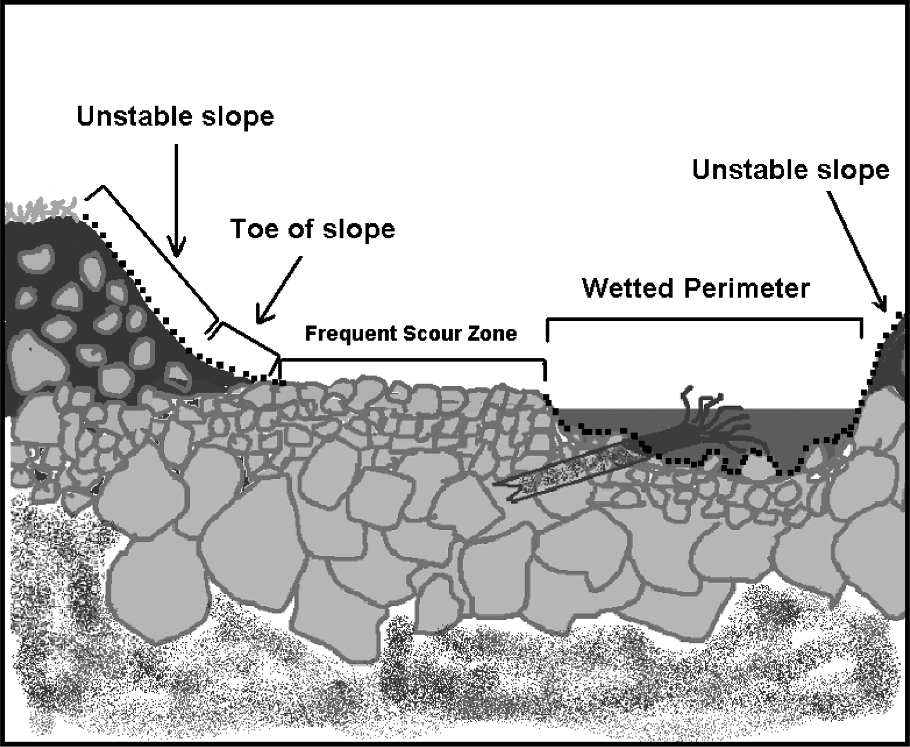 |
Figure 1: Cross section of a typical body of water, showing areas where excavation is not permitted under rules for mineral prospecting without timing restrictions. Dashed lines indicate areas where excavation is not permitted.
(iii) A person may work in only one excavation site at a time. However, a person may use a second excavation site as a settling pond. Multiple persons may work within a single excavation site.
(iv) When collecting or excavating aggregate, a person may not stand within, or allow aggregate to enter, the wetted perimeter.
(v) A person must fill all excavation sites and level all tailing piles before moving to another excavation site or abandoning an excavation site. If a person moves boulders, a person must return them, as well as possible, to their original location.
(vi) A person may not undermine, move, or disturb large woody material embedded in the slopes or located wholly or partially within the wetted perimeter. A person may move large woody material and boulders located entirely within the frequent scour zone, but a person must keep them within the frequent scour zone. A person may not cut large woody material. See Figure 2.
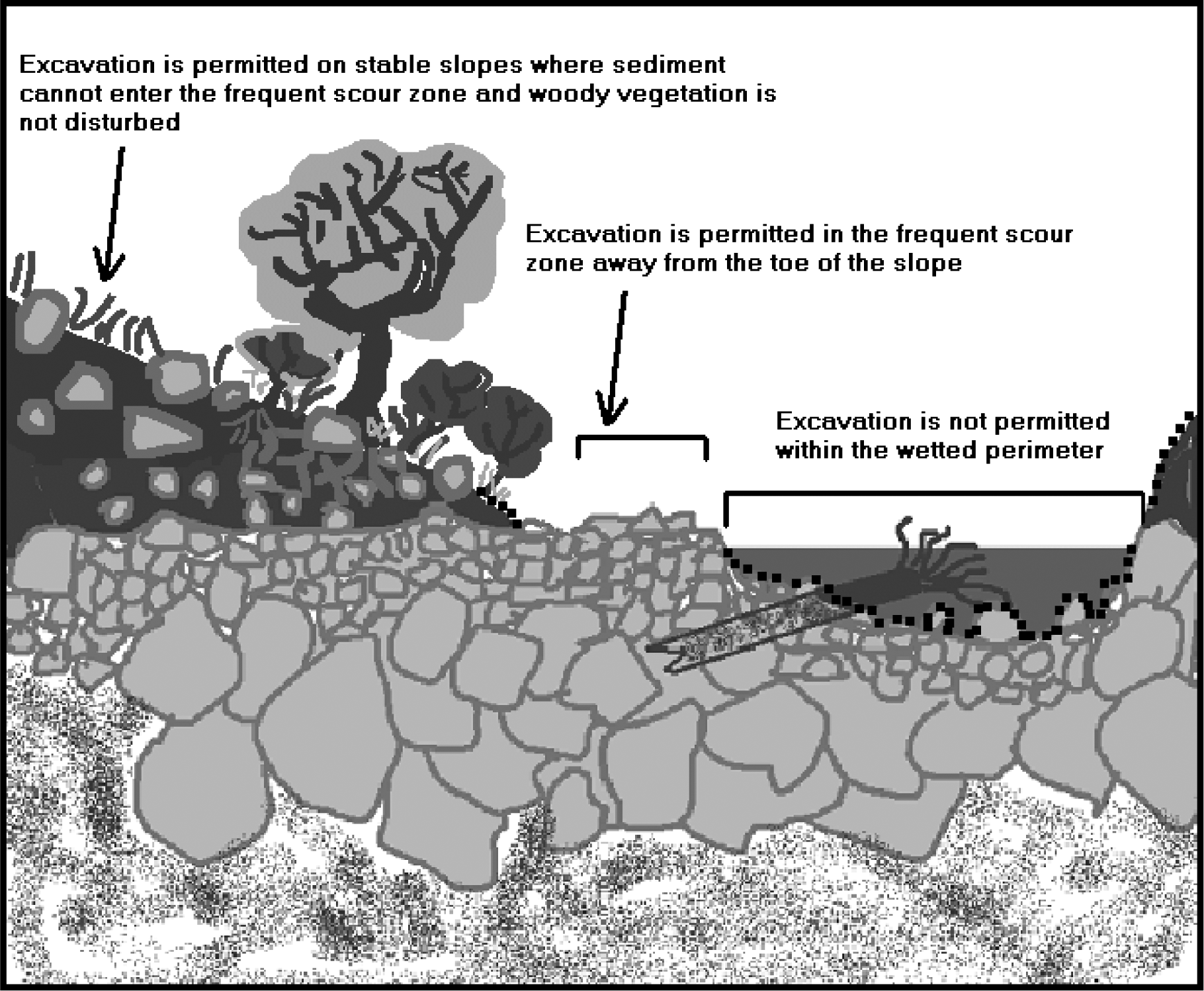 |
Figure 2: Permitted and prohibited excavation sites in a typical body of water under rules for mineral prospecting without timing restrictions. Dashed lines indicate areas where excavation is not permitted.
(vii) A person may not undermine, cut, or disturb live, rooted woody vegetation of any kind.
(viii) A person may not excavate, collect, or remove aggregate from the toe of the slope. A person also may not excavate, collect, or remove aggregate from an unstable slope or any slope that delivers, or might deliver sediment to the wetted perimeter or frequent scour zone. See Figures 3 and 4.
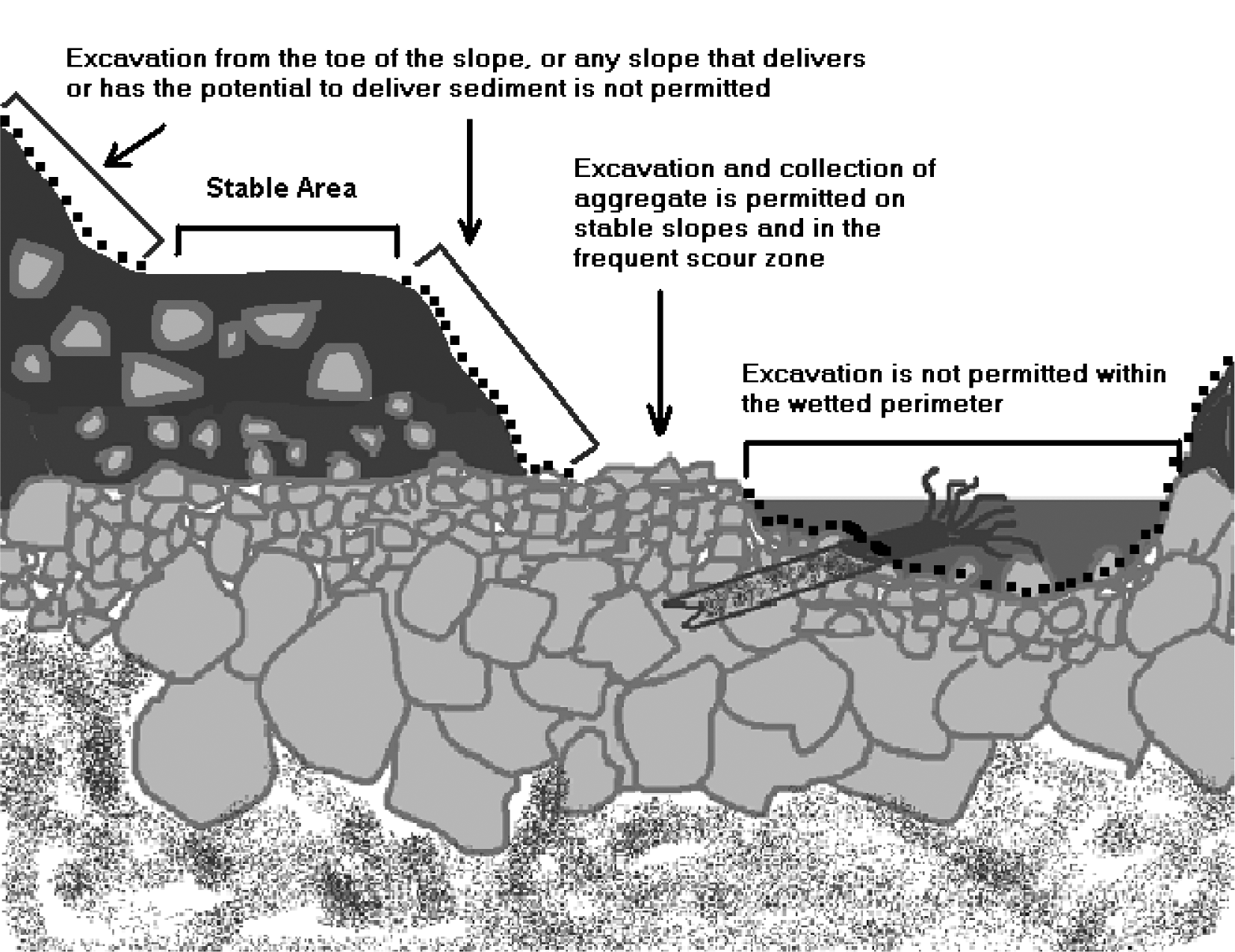 |
Figure 3: Limits on excavating, collecting, and removing aggregate on stream banks.
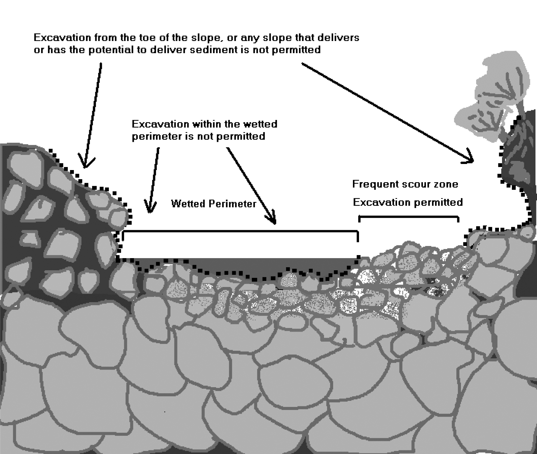 |
Figure 4: Excavating, collecting and removing aggregate within the wetted perimeter is not permitted.
(g) Processing aggregate:
(i) A person may stand within the wetted perimeter when processing aggregate with pans, spiral wheels, and sluices.
(ii) A person may not stand on or process directly on redds, or disturb incubating fish life. A person may not allow tailings or visible sediment plumes (visibly muddy water) to enter redds or areas where fish life are located within the bed.
(iii) A person may not level or disturb tailing piles that remain within the wetted perimeter after processing aggregate.
(iv) If a person collected or excavated aggregate outside of the frequent scour zone, a person must classify it at the collection or excavation site before processing.
(v) When using a sluice, a person may process only classified aggregate within the wetted perimeter.
(vi) The maximum width of a sluice, measured at its widest point, including attachments, must not exceed twenty-five percent of the width of the wetted perimeter at the point of placement.
(vii) A person may process with a sluice only in areas within the wetted perimeter that are composed mainly of boulders and bedrock. A person must separate sluice locations by at least fifty feet. A person may not place structures within the wetted perimeter to check or divert the water flow.
(viii) A person may operate mini high-bankers or other concentrators only outside the wetted perimeter. A person may not allow visible sediment or muddy water to enter the wetted perimeter. A second excavation site may be used as a settling pond.
(ix) As provided in RCW 77.57.010 and 77.57.070, any device a person uses for pumping water from fish-bearing waters must be equipped with a fish guard to prevent fish from entering the pump intake. A person must screen the pump intake with material that has openings no larger than five sixty-fourths inch for square openings, measured side to side, or three thirty-seconds inch diameter for round openings, and the screen must have at least one square inch of functional screen area for every gallon per minute (gpm) of water drawn through it. For example, a one hundred gpm-rated pump would require a screen with a surface area of at least one hundred square inches.
(x) A person may not excavate, collect, remove, or process aggregate within four hundred feet of any fishway, dam, or hatchery water intake.
(xi) A person may not disturb existing fish habitat improvement structures or stream channel improvements.
(xii) All equipment fueling and servicing must be done so that petroleum products do not enter the wetted perimeter or frequent scour zone. If a petroleum sheen or spill is observed, a person must immediately stop work, remove the equipment from the body of water, and contact the Washington military department emergency management division. A person may not return the equipment to the water until the problem is corrected. A person must store fuel and lubricants outside the frequent scour zone, and in the shade when possible.
(xiii) If at any time, as a result of project activities, a person observes a fish kill or fish life in distress, a person must immediately cease operations and notify the department and the Washington military department emergency management division of the problem. A person may not resume work until the department gives approval. The department will require additional measures to mitigate the prospecting impacts.
(5) Mineral prospecting in fresh waters with timing restrictions:
(a) A person may mineral prospect in fresh waters of the state only during the times and with the mineral prospecting equipment limitations identified in subsection (7) of this section. A person must have the Gold and Fish pamphlet on the job site and comply with the provisions listed below.
(b) When mineral prospecting with timing restrictions, a person may use only hand-held mineral prospecting tools and the following mineral prospecting equipment:
(i) Pans;
(ii) Spiral wheels;
(iii) Sluices, concentrators, rocker boxes, and high-bankers with riffle areas totaling ten square feet or less, including ganged equipment;
(iv) Suction dredges that have suction intake nozzles with inside diameters that should be five inches or less, but must be no greater than five and one-quarter inches to account for manufacturing tolerances and possible deformation of the nozzle. The inside diameter of the dredge hose attached to the nozzle may be no greater than one inch larger than the nozzle size. See Figure 5.
 |
Figure 5: Dredge intake nozzle
(v) Power sluice/suction dredge combinations that have riffle areas totaling ten square feet or less, including ganged equipment; suction intake nozzles with inside diameters that should be five inches or less, but must be no greater than five and one-quarter inches to account for manufacturing tolerances and possible deformation of the nozzle; and pump intake hoses with inside diameters of four inches or less. The inside diameter of the dredge hose attached to the suction intake nozzle may be no greater than one inch larger than the nozzle size. See Figure 5; and
(vi) High-bankers and power sluices that have riffle areas totaling ten square feet or less, including ganged equipment, and pump intake hoses with inside diameters of four inches or less.
(c) The widest point of a sluice, including attachments, must not exceed twenty-five percent of the width of the wetted perimeter at the point of placement.
(d) The suction intake nozzle and hose of suction dredges and power sluice/suction dredge combinations must not exceed the diameters allowed in the listing for the stream or stream reach where a person is operating, as identified in subsection (7) of this section.
(e) A person may not use vehicle-mounted winches. A person may use one motorized winch and one hand-operated winch to move boulders and large woody material that is not embedded, and additional cables, chains, or ropes to stabilize them.
(f) Equipment separation:
(i) A person may use hand-held mineral prospecting tools; pans; spiral wheels; or sluices, mini rocker boxes, or mini high-bankers with riffle areas totaling three square feet or less, including ganged equipment, as close to other mineral prospecting equipment as desired.
(ii) When operating any sluice or rocker box with a riffle area larger than three square feet (including ganged equipment), suction dredge, power sluice/suction dredge combination, high-banker, or power sluice within the wetted perimeter, a person's equipment must be at least two hundred feet from all others also operating this type of equipment. This separation is measured as a radius from the center of the equipment the person is operating. A person may locate this equipment closer than two hundred feet if only one piece of equipment is actually operating within that two hundred foot radius. See Figure 6.
(iii) When operating any sluice or rocker box with a riffle area larger than three square feet (including ganged equipment), suction dredge, power sluice/suction dredge combination, high-banker, or power sluice outside of the wetted perimeter that discharges tailings or wastewater to the wetted perimeter, a person's equipment must be at least two hundred feet from all others also operating this type of equipment. This separation is measured as a radius from the center of the equipment the person is operating. A person may locate this equipment closer than two hundred feet if only one piece of equipment is actually operating within that two hundred-foot radius. See Figure 6.
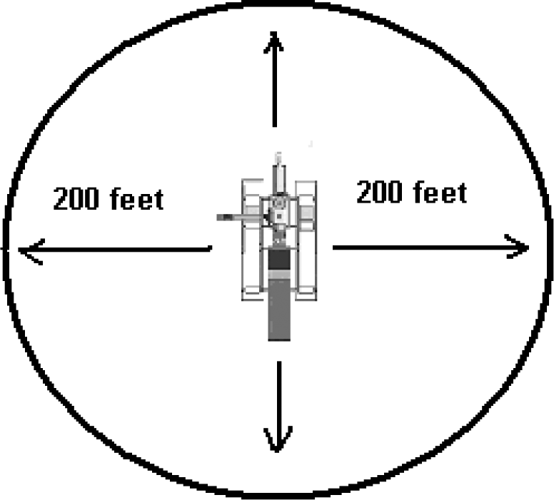 |
Figure 6: Equipment separation requirement.
(g) As provided in RCW 77.57.010 and 77.57.070, any device a person uses for pumping water from fish-bearing waters must be equipped with a fish guard to prevent fish from entering the pump intake. A person must screen the pump intake with material that has openings no larger than five sixty-fourths inch for square openings, measured side to side, or three thirty-seconds inch diameter for round openings, and the screen must have at least one square inch of functional screen area for every gallon per minute (gpm) of water drawn through it. For example, a one hundred gpm-rated pump would require a screen with a surface area of at least one hundred square inches.
(h) All equipment fueling and servicing must be done so that petroleum products do not enter the wetted perimeter or frequent scour zone. If a petroleum sheen or spill is observed, a person must immediately stop work, remove the equipment from the body of water, and contact the Washington military department emergency management division. A person may not return the equipment to the water until the problem is corrected. A person must store fuel and lubricants outside the frequent scour zone, and in the shade when possible.
(i) A person may work within the wetted perimeter or frequent scour zone only from one-half hour before official sunrise to one-half hour after official sunset. If a person's mineral prospecting equipment exceeds one-half the width of the wetted perimeter of the stream, a person must remove the equipment from the wetted perimeter or move it so that at least fifty percent of the wetted perimeter is free of equipment from one-half hour after official sunset to one-half hour before official sunrise.
(j) A person may not excavate, collect, remove, or process aggregate within four hundred feet of any fishway, dam, or hatchery water intake.
(k) A person must not disturb existing fish habitat improvement structures or stream channel improvements.
(l) A person may not undermine, move, or disturb large woody material embedded in the slopes or located wholly or partially within the wetted perimeter. A person may move large woody material and boulders located entirely within the frequent scour zone, but a person must keep them within the frequent scour zone. A person may not cut large woody material.
(m) A person may not undermine, cut, or disturb live, rooted woody vegetation of any kind.
(n) A person may work in only one excavation site at a time. However, a person may use a second excavation site as a settling pond. Multiple individuals may work within a single excavation site.
(o) A person must fill all excavation sites and level all tailing piles before moving to another excavation site or abandoning an excavation site.
(p) A person may not excavate, collect, or remove aggregate from the toe of the slope. A person also may not excavate, collect, or remove aggregate from an unstable slope or any slope that delivers, or might deliver, sediment to the wetted perimeter or frequent scour zone. See Figures 7 and 8.
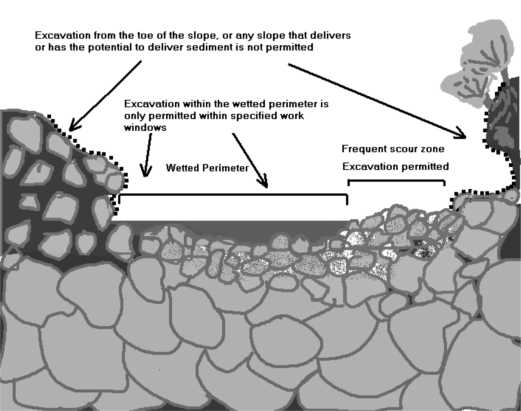 |
Figure 7: Cross section of a typical body of water showing unstable slopes, stable areas, and permitted or prohibited excavation sites under rules for mineral prospecting with timing restrictions. Dashed line indicates areas where excavation is not permitted.
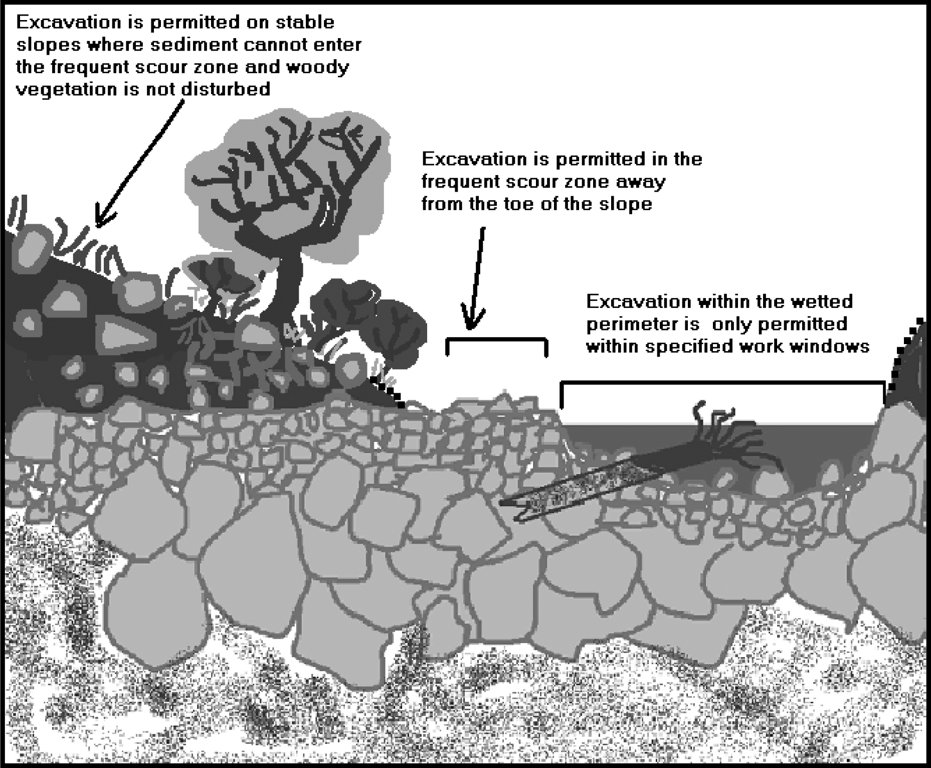 |
Figure 8: ((Cross section of a typical body of water showing unstable slopes, stable areas, and)) Permitted ((or)) and prohibited excavation sites in a typical body of water under rules for mineral prospecting with timing restrictions. Dashed lines indicates areas where excavation is not permitted.
(q) A person may partially divert a body of water into mineral prospecting equipment. However, at no time may the diversion structure be greater than fifty percent of the width of the wetted perimeter, including the width of the equipment. A person may not divert the body of water outside of the wetted perimeter.
(r) A person may use materials only from within the wetted perimeter, or artificial materials from outside the wetted perimeter, to construct the diversion structure by hand. Before abandoning the site, a person must remove artificial materials used to construct a diversion structure and restore the site to its approximate original condition.
(s) A person may process aggregate collected from the frequent scour zone:
(i) At any location if a person uses pans; spiral wheels; mini rocker boxes; mini high-bankers; or sluices or other concentrators with riffle areas three square feet or less, including ganged equipment.
(ii) Only in the frequent scour zone or upland areas landward of the frequent scour zone if a person uses power sluice/suction dredge combinations, high-bankers, or power sluices with riffle areas totaling ten square feet or less, including ganged equipment; or sluices or rocker boxes that have riffle areas larger than three, but less than ten square feet, including ganged equipment. A person may not discharge tailings to the wetted perimeter when using this equipment. However, a person may discharge wastewater to the wetted perimeter if its entry point into the wetted perimeter is at least two hundred feet from any other wastewater discharge entry point.
(t) A person may process aggregate collected from upland areas landward of the frequent scour zone:
(i) At any location if a person uses pans; spiral wheels; or sluices, concentrators, mini rocker boxes, and mini high-bankers with riffle areas totaling three square feet or less, including ganged equipment. A person must classify the aggregate at the excavation site before processing with this equipment within the wetted perimeter or frequent scour zone.
(ii) Only at an upland location landward of the frequent scour zone if a person uses power sluice/suction dredge combinations; high-bankers; power sluices; or rocker boxes. A person may not allow tailings or wastewater to enter the wetted perimeter or frequent scour zone.
(iii) Within the wetted perimeter or frequent scour zone if a person uses a sluice with a riffle area greater than three square feet. A person must classify the aggregate at the excavation site prior to processing with a sluice with a riffle area exceeding three square feet.
(u) A person may use pressurized water only for crevicing or for redistributing dredge tailings within the wetted perimeter. No other use of pressurized water is permitted.
(v) A person may conduct crevicing in the wetted perimeter, in the frequent scour zone, or landward of the frequent scour zone. The hose connecting fittings of pressurized water tools used for crevicing may not have an inside diameter larger than three-quarters of an inch. If a person crevices landward of the frequent scour zone, no sediment or wastewater may be discharged into the wetted perimeter or the frequent scour zone.
(w) A person must avoid areas containing live freshwater mussels. If a person encounters live mussels during excavation, a person must relocate the operation.
(x) A person may not disturb redds. If a person observes or encounters redds or actively spawning fish when collecting or processing aggregate, a person must relocate the operation.
(y) If at any time, as a result of project activities, a person observes a fish kill or fish life in distress, a person must immediately stop operations and notify the department and the Washington military department emergency management division of the problem. A person may not resume work until the department gives approval. The department will require additional measures to mitigate the prospecting impacts.
(6) Mineral prospecting on ocean beaches:
(a) A person may mineral prospect year-round on ocean beaches of the state. A person must follow the rules listed below, and must have the Gold and Fish pamphlet on the job site when working on ocean beaches of the state, except as noted in this subsection.
(b) A person may mineral prospect only between the line of ordinary high tide and the line of extreme low tide on beaches within the Seashore Conservation Area set under RCW 79A.05.605 and managed by Washington state parks and recreation commission.
(c) No written or pamphlet HPA is required to mineral prospect south of the Copalis River, if a person operates landward of the upper limit of ghost shrimp burrowing in the beach; waterward of the ordinary high tide line; and a person does not use fresh water from fish-bearing streams during operations. See Figure 9.
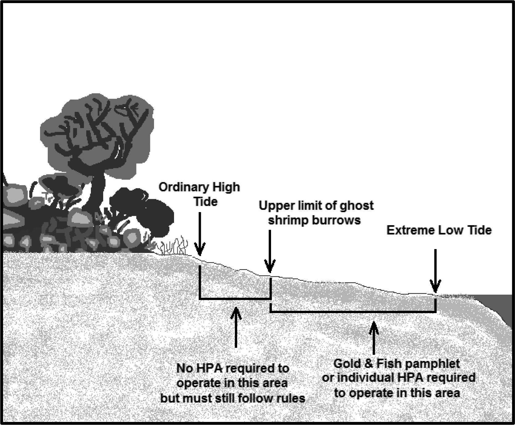 |
Figure 9. Beach area where no written or pamphlet HPA is required.
(d) A person may use only hand-held mineral prospecting tools and the following mineral prospecting equipment:
(i) Pans;
(ii) Spiral wheels;
(iii) Sluices, concentrators, rocker boxes, and high-bankers with riffle areas totaling ten square feet or less, including ganged equipment;
(iv) Suction dredges that have suction intake nozzles with inside diameters that should be five inches or less, but must be no greater than five and one-quarter inches to account for manufacturing tolerances and possible deformation of the nozzle. The inside diameter of the dredge hose attached to the nozzle may be no greater than one inch larger than the nozzle size;
(v) Power sluice/suction dredge combinations that have riffle areas totaling ten square feet or less, including ganged equipment; suction intake nozzles with inside diameters that should be five inches or less, but must be no greater than five and one-quarter inches to account for manufacturing tolerances and possible deformation of the nozzle; and pump intake hoses with inside diameters of four inches or less. The inside diameter of the dredge hose attached to the suction intake nozzle may be no greater than one inch larger than the nozzle size; and
(vi) High-bankers and power sluices that have riffle areas totaling ten square feet or less, including ganged equipment, and pump intake hoses with inside diameters of four inches or less.
(e) When operated in fish-bearing freshwater streams, the widest point of a sluice, including attachments, must not exceed twenty-five percent of the width of the wetted perimeter at the point of placement.
(f) A person may not use vehicle-mounted winches. A person may use one motorized winch and one hand-operated winch to move boulders and large woody material that is not embedded, and additional cables, chains, or ropes to stabilize them.
(g) Under RCW 77.57.010 and 77.57.070, any device a person uses for pumping water from fish-bearing waters must be equipped with a fish guard to prevent fish from entering the pump intake. A person must screen the pump intake with material that has openings no larger than five sixty-fourths inch for square openings, measured side to side, or three thirty-seconds inch diameter for round openings, and the screen must have at least one square inch of functional screen area for every gallon per minute (gpm) of water drawn through it. For example, a one hundred gpm-rated pump would require a screen with a surface area of at least one hundred square inches.
(h) All equipment fueling and servicing must be done so that petroleum products do not enter the wetted perimeter. If a petroleum sheen or spill is observed, a person must immediately stop work, remove the equipment from the body of water and beach, and contact the Washington military department emergency management division. A person may not return the equipment to the water or beach until the problem is corrected. A person must store fuel and lubricants away from the water inside a vehicle or landward of the beach, and in the shade when possible.
(i) A person may work only from one-half hour before official sunrise to one-half hour after official sunset. If a person uses mineral prospecting equipment in a fish-bearing freshwater stream and the equipment exceeds one-half the width of the wetted perimeter of the stream, a person must remove the equipment from the wetted perimeter or move it so that at least fifty percent of the wetted perimeter is free of equipment from one-half hour after official sunset to one-half hour before official sunrise.
(j) A person may not undermine, cut, disturb, or move embedded large woody material or woody debris jams.
(k) A person may work in only one excavation site at a time. However, a person may use a second excavation site as a settling pond. Multiple persons may work within a single excavation site.
(l) A person must backfill all trenches, depressions, or holes created in the beach during project activities before moving to another excavation site (except during use as a settling pond) or leaving an excavation site.
(m) A person may partially divert a body of water into mineral prospecting equipment. However, at no time may the diversion structure be greater than fifty percent of the width of the wetted perimeter of a fish-bearing freshwater stream, including the width of the equipment. A person may not divert the body of water outside of the wetted perimeter.
(n) A person may use materials only from within the wetted perimeter, or artificial materials from outside the wetted perimeter, to construct the diversion structure by hand. Before abandoning the site, a person must remove artificial materials used to construct a diversion structure and restore the site to its approximate original condition.
(o) A person may use pressurized water only for redistributing dredge tailings within the wetted perimeter. No other use of pressurized water is permitted.
(p) A person may not disturb live razor clams or other shellfish within the bed. If a person observes or encounters live razor clams or other shellfish during excavation, the person must relocate the operation.
(q) If at any time, as a result of project activities, a person observes a fish kill or fish life in distress, a person must immediately stop operations and notify the department, and the Washington military department emergency management division of the problem. A person may not resume work until the department gives approval. The department will require additional measures to mitigate the prospecting impacts.
(7) Authorized work times and mineral prospecting equipment restrictions by specific state waters for mineral prospecting and placer mining projects:
(a) A person may conduct mineral prospecting and placer mining under subsections (5) and (6) of this section only in the state waters, with the equipment restrictions, and during the times specified in the following table of authorized work times.
(b) The general work time for a county applies to all state waters within that county, unless otherwise indicated in the table.
(c) The work time for state waters identified in the table of authorized work times applies to all its tributaries, unless otherwise indicated. Some state waters occur in multiple counties. Check the table for the county in which mineral prospecting or placer mining is to be conducted to determine the work time for that water body.
(d) Where a tributary is identified as a boundary, that boundary is the line perpendicular to the receiving stream that is projected from the most upstream point of the tributary mouth to the opposite bank of the receiving stream. See Figure 10.
(e) Mineral prospecting and placer mining within water bodies identified in the table of authorized work times as "submit application" are not authorized under the Gold and Fish pamphlet. A person must obtain a written individual HPA to work in these water bodies.
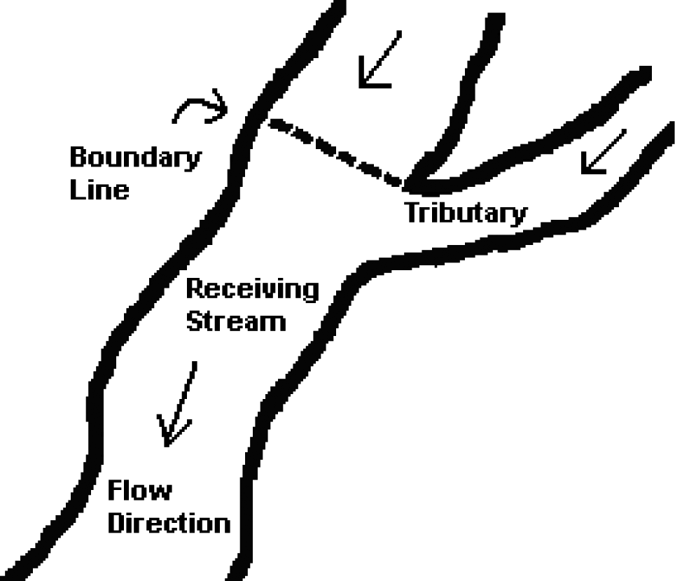 |
Figure 10: Where the boundary is located if a tributary listed as a boundary.
(f) Mineral prospecting using mineral prospecting equipment that has suction intake nozzles with inside diameters that should be four inches or less, but must be no greater than four and one-quarter inches to account for manufacturing tolerances and possible deformation of the nozzle, is authorized only in the state waters identified in the table of authorized work times, and any tributaries to them, unless otherwise indicated in the table. The inside diameter of the dredge hose attached to the nozzle may be no greater than one inch larger than the nozzle size.
(g) Mineral prospecting using mineral prospecting equipment that has suction intake nozzles with inside diameters that should be five inches or less, but must be no greater than five and one-quarter inches to account for manufacturing tolerances and possible deformation of the nozzle is authorized only in the state waters specifically identified in the table of authorized work times. The inside diameter of the dredge hose attached to the nozzle may be no greater than one inch larger than the nozzle size. A person may use only mineral prospecting equipment with suction intake nozzle inside diameters of four and one-quarter inches or less in tributaries of these state waters. The inside diameter of the dredge hose attached to the nozzle may be no greater than one inch larger than the nozzle size.
Table 3
Authorized Work Times and Mineral Prospecting Equipment Restrictions by Specific State Waters for Mineral Prospecting and Placer Mining Projects
Washington Counties and State Waters (Water Resource Inventory Area (WRIA) in parentheses) |
Mineral Prospecting is Allowed Only Between These Dates |
State Waters (and tributaries, unless otherwise indicated) in Which a Person May Use Mineral Prospecting Equipment With a Four and One-Quarter Inch Maximum Suction Intake Nozzle Inside Diameter |
State Waters (NOT including tributaries) in Which a Person May Use Mineral Prospecting Equipment With a Five and One-Quarter Inch Maximum Suction Intake Nozzle Inside Diameter |
Adams County |
July 1 - October 31 |
X |
– |
Crab Creek (41.0002) |
July 16 - February 28 |
X |
X |
Esquatzel Creek (36.MISC) |
June 1 - February 28 |
X |
X |
Palouse River (34.0003) |
July 16 - February 28 |
X |
X |
Asotin County |
July 16 - September 15 |
X |
– |
Snake River (35.0002) |
See Below |
– |
– |
Alpowa Creek (35.1440) |
July 16 - December 15 |
X |
– |
Asotin Creek (35.1716) |
July 16 - August 15 |
X |
– |
Couse Creek (35.2147) |
July 16 - December 15 |
X |
– |
Grande Ronde River (35.2192) |
July 16 - September 15 |
X |
X |
Ten Mile Creek (35.2100) |
July 16 - December 15 |
X |
– |
Benton County |
June 1 - September 30 |
X |
– |
Columbia River |
See Below |
– |
– |
Glade Creek (31.0851) |
August 1 - September 30 |
X |
– |
Yakima River (37.0002) |
June 1 - September 15 |
X |
X |
Amon Wasteway (37.0009) |
June 1 - September 30 |
X |
– |
Corral Creek (37.0002) |
June 1 - September 30 |
X |
– |
Spring Creek (37.0205) |
June 1 - September 30 |
X |
– |
Chelan County |
July 16 - August 15 |
X |
– |
Columbia River |
See Below |
– |
– |
Antoine Creek (49.0294) - Mouth to falls at river mile 1.0 |
July 1 - February 28 |
X |
– |
Antoine Creek (49.0294) - Upstream of falls at river mile 1.0 |
July 1 - March 31 |
X |
– |
Chelan River (47.0052) - Mouth to Chelan Dam |
July 16 - September 30 |
X |
X |
Colockum Creek (40.0760) |
July 1 - October 31 |
X |
– |
Entiat River (46.0042) - Mouth to Entiat Falls |
July 16 - July 31 |
X |
X |
Entiat River (46.0042) - Upstream of Entiat Falls |
July 16 - March 31 |
X |
– |
Crum Canyon (46.0107) |
July 16 - March 31 |
X |
– |
Mad River (46.0125) |
July 16 - July 31 |
X |
– |
Indian Creek (46.0128) |
July 16 - February 28 |
X |
– |
Lake Chelan (47.0052) |
Submit Application |
– |
– |
Railroad Creek (47.0410) |
July 16 - September 30 |
X |
– |
Stehekin River (47.0508) |
Submit Application |
– |
– |
Twenty-Five Mile Creek (47.0195) |
July 16 - September 30 |
X |
– |
Other Lake Chelan tributaries outside of North Cascades National Park |
July 1 - August 15 |
X |
– |
Other Lake Chelan tributaries within North Cascades National Park |
Submit Application |
– |
– |
Number 1 Canyon (45.0011) |
July 1 - February 28 |
X |
– |
Number 2 Canyon (45.0012) |
July 1 - February 28 |
X |
– |
Squilchuck Creek (40.0836) - Mouth to South Wenatchee Avenue |
July 1 - September 30 |
X |
– |
Squilchuck Creek (40.0836) - Upstream of South Wenatchee Avenue |
July 1 - February 28 |
X |
– |
Stemilt Creek (40.0808) - Mouth to falls |
July 1 - September 30 |
X |
– |
Stemilt Creek (40.0808) - Upstream of falls |
July 1 - February 28 |
X |
– |
Wenatchee River (45.0030) - Mouth to Hwy 2 Bridge in Leavenworth |
July 15 - September 30 |
X |
X |
Wenatchee River (45.0030) - Hwy 2 Bridge in Leavenworth to Lake Wenatchee |
July 15 - August 15 |
X |
X |
Beaver Creek (45.0751) |
July 1 - September 30 |
X |
– |
Chiwaukum Creek (45.0700) |
July 1 - July 31 |
X |
– |
Chiwawa River (45.0759) - Mouth to Phelps Creek |
July 1 - July 31 |
X |
X |
Chiwawa River (45.0759) - Upstream of Phelps Creek |
July 1 - July 31 |
X |
– |
Deep Creek (45.0764) |
July 1 - February 28 |
X |
– |
Phelps Creek (45.0875) |
July 16 - August 15 |
X |
– |
Icicle Creek (45.0474) - Mouth to Johnny Creek |
July 1 - July 31 |
X |
X |
Icicle Creek (45.0474) - Upstream of Johnny Creek |
July 1 - July 31 |
X |
– |
Fourth of July Creek (45.0525) |
July 1 - February 28 |
X |
– |
Lake Wenatchee (45.0030) |
Submit Application |
– |
– |
Little Wenatchee (45.0985) - Mouth to Wilderness Boundary |
July 1 - July 31 |
X |
X |
Little Wenatchee (45.0985) - Upstream of Wilderness Boundary |
Submit Application |
– |
– |
White River (45.1116) - Mouth to White River Falls |
July 1 - July 31 |
X |
X |
White River (45.1116) - Upstream of White River Falls |
July 1 - February 28 |
X |
– |
Nason Creek (45.0888) |
July 1 - July 31 |
X |
– |
Peshastin Creek (45.0232) - Mouth to ((Negro)) Etienne Creek |
July 16 - August 15 |
X |
– |
Peshastin Creek (45.0232) - Upstream of ((Negro)) Etienne Creek |
August 1 - February 28 |
X |
– |
Ingalls Creek (45.0273) - Mouth to Cascade Creek |
Submit Application |
– |
– |
Ingalls Creek (45.0273) - Upstream of Cascade Creek |
July 16 - February 28 |
X |
– |
((Negro)) Etienne Creek (45.0323) - Mouth to falls at stream mile 2.9 |
Submit Application |
– |
– |
((Negro)) Etienne Creek (45.0323) - Upstream of falls at stream mile 2.9 |
July 16 - February 28 |
X |
– |
Ruby Creek (45.0318) |
July 16 - February 28 |
X |
– |
Tronson Creek (45.0346) |
August 1 - February 28 |
X |
– |
Scotty Creek (45.0376) |
August 1 - February 28 |
X |
– |
Shaser Creek (45.0365) |
August 1 - February 28 |
X |
– |
Clallam County |
July 16 - September 15 |
X |
– |
Clallam River (19.0129) |
August 1 - August 15 |
X |
– |
Dungeness River (18.0018) |
Submit Application |
– |
– |
Independent Creek (18.MISC) |
August 1 - August 31 |
X |
– |
Elwha River (18.0272) |
August 1 - August 15 |
X |
X |
Hoko River (19.0148) |
August 1 - September 15 |
X |
– |
Jimmycomelately Creek (17.0285) |
August 1 - August 31 |
X |
– |
Lake Ozette (20.0046) |
Submit Application |
– |
– |
Little Quilcene River (17.0076) |
July 16 - August 31 |
X |
– |
Lake Ozette tributaries |
July 16 - September 15 |
X |
– |
Lyre River (19.0031) |
August 1 - September 15 |
X |
– |
McDonald Creek (18.0160) |
August 1 - September 15 |
X |
– |
Morse Creek (18.0185) |
August 1 - August 15 |
X |
– |
Ozette River (20.0046) |
July 16 - September 15 |
X |
– |
Pysht River (19.0113) |
August 1 - September 15 |
X |
– |
Quillayute River (20.0096, 20.0162, 20.0175) |
August 1 - August 15 |
X |
X |
Bogachiel River (20.0162) |
Submit Application |
– |
– |
Calawah River (20.0175) |
August 1 - August 15 |
X |
X |
Salmon Creek (17.0245) |
July 16 - August 31 |
X |
– |
Sekiu River (19.0203) |
August 1 - September 15 |
X |
– |
Snow Creek (17.0219) |
July 16 - August 31 |
X |
– |
Sol Duc River (20.0096) |
Submit Application |
– |
– |
Lake Pleasant (20.0313) |
Submit Application |
– |
– |
Lake Pleasant tributaries |
July 16 - September 15 |
X |
– |
Sooes River (20.0015) |
July 16 - September 15 |
X |
– |
Clark County |
July 16 - September 30 |
– |
– |
Columbia River |
See Below |
– |
– |
Lacamas Creek (28.0160) - Mouth to dam |
August 1 - August 31 |
X |
– |
Lacamas Creek (28.0160) - Upstream of dam |
August 1 - September 30 |
X |
– |
Lewis River (27.0168) |
August 1 - August 15 |
X |
X |
East Fork Lewis River (27.0173) - Mouth to Lucia Falls |
August 1 - August 15 |
X |
X |
East Fork Lewis River (27.0173) - Lucia Falls to Sunset Falls |
August 1 - February 28 |
X |
X |
East Fork Lewis River (27.0173) - Upstream of Sunset Falls |
August 1 - February 28 |
X |
– |
Lake River (28.0020) |
January 1 - December 31 |
X |
X |
Burnt Bridge Creek (28.0143) |
August 1 - August 31 |
X |
– |
Salmon Creek (28.0059) |
August 1 - August 31 |
X |
– |
Whipple Creek (28.0038) |
August 1 - September 30 |
X |
– |
North Fork Lewis River (27.0334) - Confluence of East Fork to Merwin Dam |
August 1 - August 15 |
X |
X |
Cedar Creek (27.0339) |
August 1 - September 15 |
X |
– |
North Fork Lewis River (27.0334) - Merwin Dam to Lower Falls |
July 16 - August 15 |
X |
X |
Canyon Creek (27.0442) |
July 16 - February 28 |
X |
– |
North Fork Lewis River (27.0168) - Upstream of Lower Falls |
July 16 - August 15 |
X |
X |
Washougal River (28.0159) - Mouth to headwaters |
August 1 - August 31 |
X |
X |
Columbia County |
July 16 - September 30 |
X |
– |
Touchet River (32.0097) |
August 1 - August 15 |
X |
X |
Grande Ronde River tributaries (35.2192) |
July 16 - August 15 |
X |
– |
North Fork Touchet/Wolf Fork (32.0761) |
Submit Application |
– |
– |
South Fork Touchet (32.0708) |
Submit Application |
– |
– |
Tucannon River (35.0009) |
July 16 - August 15 |
X |
X |
Walla Walla River (32.0008) - Mouth to Oregon state line |
July 16 - September 15 |
X |
X |
Mill Creek (32.1436) - Mouth to Oregon state line |
August 1 - August 15 |
X |
– |
Cowlitz County |
July 16 - September 30 |
X |
– |
Chehalis River (22.0190/23.0190) - South Fork Chehalis River - Mouth to Fisk Falls |
August 1 - August 31 |
X |
X |
Chehalis River (22.0190/23.0190) - South Fork Chehalis River - Upstream of Fisk Falls |
August 1 - August 31 |
X |
– |
Columbia River |
See Below |
– |
– |
Abernathy Creek (25.0297) |
July 16 - September 15 |
X |
– |
Burke Creek (27.0148) |
August 1 - August 31 |
X |
– |
Burris Creek (27.0151) |
August 1 - August 31 |
X |
– |
Bybee Creek (27.0142) |
August 1 - August 31 |
X |
– |
Canyon Creek (27.0147) |
August 1 - August 31 |
X |
– |
Coal Creek (25.0340) |
July 16 - September 15 |
X |
– |
Clark Creek (25.0371) |
August 1 - August 31 |
X |
– |
Cowlitz River (26.0002) - Mouth to barrier dam at river mile 49.5 |
July 16 - August 15 |
X |
X |
Coweeman River (26.0003) - Mouth to Baird Creek |
August 1 - August 31 |
X |
X |
Coweeman River (26.0003) - Upstream of Baird Creek |
August 1 - August 31 |
X |
– |
Cowlitz River (26.0002) - Tributaries below barrier dam to mouth |
July 16 - September 30 |
X |
– |
Owl Creek (26.1441) |
July 16 - September 15 |
X |
– |
Toutle River (26.0227) |
July 16 - August 15 |
X |
X |
North Fork Toutle River (26.0314) - Mouth to Debris Dam |
July 16 - August 15 |
X |
X |
North Fork Toutle River (26.0314) - Upstream of Debris Dam |
July 16 - August 15 |
X |
– |
Green River (26.0323) - Mouth to Shultz Creek |
July 16 - September 30 |
X |
X |
Green River (26.0323) - Upstream of Shultz Creek |
July 16 - September 30 |
X |
– |
South Fork Toutle (26.0248) - Mouth to Bear Creek |
July 16 - September 15 |
X |
X |
South Fork Toutle (26.0248) - Upstream of Bear Creek |
July 16 - September 15 |
X |
– |
Tributaries to Silver Lake |
July 16 - September 30 |
X |
– |
Germany Creek (25.0313) |
July 16 - September 15 |
X |
– |
Kalama River (27.0002) - Mouth to Kalama Falls |
August 1 - August 15 |
X |
X |
Kalama River (27.0002) - Upstream of Kalama Falls |
August 1 - August 15 |
X |
– |
Lewis River (27.0168) - Mouth to East Fork Lewis River |
August 1 - August 15 |
X |
X |
North Fork Lewis River (27.0334) - Confluence of East Fork to Merwin Dam |
August 1 - August 15 |
X |
X |
North Fork Lewis River (27.0334) - Merwin Dam to Lower Falls |
July 16 - August 15 |
X |
X |
Mill Creek (25.0284) |
July 16 - September 15 |
X |
– |
Schoolhouse Creek (27.0139) |
August 1 - August 31 |
X |
– |
Douglas County |
July 1 - September 30 |
X |
– |
Columbia River |
See Below |
– |
– |
Douglas Creek Canyon (44.0146) |
May 16 - January 31 |
X |
– |
Foster Creek (50.0065) |
August 1 - April 15 |
X |
– |
McCarteney Creek (44.0002) |
July 1 - February 28 |
X |
– |
Pine/Corbaley Canyon Creek (44.0779) |
September 16 - April 15 |
X |
– |
Rock Island Creek (44.0630) |
July 1 - September 30 |
X |
– |
Ferry County |
July 1 - August 31 |
X |
– |
Columbia River |
See Below |
– |
– |
Kettle River (60.0002) |
June 16 - August 31 |
X |
X |
Boulder Creek (60.0130) - Mouth to Hodgson Road Bridge |
Submit Application |
– |
– |
Boulder Creek (60.0130) - Upstream of Hodgson Road Bridge |
June 16 - February 28 |
X |
– |
Deadman Creek (60.0008) - Mouth to SR395 Crossing |
Submit Application |
– |
– |
Deadman Creek (60.0008) - Upstream of SR395 |
June 16 - February 28 |
X |
– |
Goosmus Creek (60.0254) |
June 16 - February 28 |
X |
– |
Toroda Creek (60.0410) |
July 1 - September 30 |
X |
– |
San Poil River (52.0004) |
June 16 - September 30 |
X |
X |
Granite Creek (52.0099) - Mouth to Powerhouse Dam |
June 16 - September 30 |
X |
– |
Granite Creek (52.0099) - Upstream of Powerhouse Dam |
June 16 - February 28 |
X |
– |
West Fork San Poil River (52.0192) - Mouth to Deep Creek |
June 16 - September 30 |
X |
X |
West Fork San Poil River (52.0192) - Upstream of Deep Creek |
June 16 - September 30 |
X |
– |
Gold Creek (52.0197) |
June 16 - February 28 |
X |
– |
Franklin County |
June 1 - September 30 |
X |
– |
Columbia River |
See Below |
– |
– |
Snake River |
See Below |
– |
– |
Palouse River (34.0003) |
July 16 - February 28 |
X |
X |
North bank tributaries of the lower Snake River between Palouse River and the mouth of the Snake River |
June 16 - October 31 |
X |
– |
Garfield County |
July 16 - September 30 |
X |
– |
Snake River (35.0003) |
See Below |
– |
– |
Alpowa Creek (35.1440) |
July 16 - December 15 |
X |
– |
Asotin Creek (35.1716) |
July 16 - August 15 |
X |
– |
Deadman Creek (35.0688) |
July 16 - December 15 |
X |
– |
Grande Ronde River tributaries (35.2192) |
July 16 - August 15 |
X |
– |
Meadow Creek (35.0689) |
July 16 - December 15 |
X |
– |
Tucannon River (35.0009) - Mouth to Panjab Creek |
July 16 - August 15 |
X |
X |
Tucannon River (35.0009) - Upstream of Panjab Creek |
July 16 - August 15 |
X |
– |
Pataha Creek (35.0123) - Mouth to Pataha Creek |
January 1 - December 31 |
X |
– |
Pataha Creek (35.0123) - Upstream of Pataha Creek |
July 16 - December 31 |
X |
– |
Grant County |
July 1 - October 31 |
X |
– |
Columbia River |
See Below |
– |
– |
Crab Creek (41.0002) |
July 16 - September 15 |
X |
X |
Grays Harbor County |
July 16 - October 15 |
X |
– |
Chehalis River (22.0190/23.0190) - Mouth to Porter Creek |
August 1 - August 31 |
X |
X |
Chehalis River (22.0190/23.0190) - Porter Creek to Fisk Falls |
August 1 - August 15 |
X |
X |
Chehalis River (22.0190/23.0190) - Upstream of Fisk Falls |
August 1 - August 15 |
X |
– |
Cedar Creek (23.0570) |
August 1 - September 30 |
X |
– |
Cloquallum Creek (22.0501) |
August 1 - September 30 |
X |
– |
Porter Creek (23.0543) |
August 1 - September 30 |
X |
– |
Satsop River (22.0360) |
August 1 - August 31 |
X |
X |
Wishkah River (22.0191) |
August 1 - October 15 |
X |
X |
Wynoochee River (22.0260) |
August 1 - September 30 |
X |
X |
Copalis River (21.0767) |
August 1 - October 15 |
X |
X |
Elk River (22.1333) |
July 1 - October 31 |
X |
X |
Hoquiam River (22.0137) |
August 1 - October 15 |
X |
X |
Humptulips River (22.0004) - Mouth to Forks |
August 1 - September 30 |
X |
X |
Humptulips River (22.0004) - Upstream of Forks |
August 1 - September 30 |
X |
– |
Johns River (22.1270) |
August 1 - September 30 |
X |
X |
Moclips River (21.0731) |
August 1 - October 15 |
X |
X |
North River (24.0034) |
August 1 - September 30 |
X |
X |
Queets River (21.0001) |
August 1 - August 15 |
X |
X |
Quinault River (21.0398) |
August 1 - August 15 |
X |
X |
Raft River (21.0337) |
August 1 - October 15 |
X |
X |
Island County |
June 16 - October 15 |
X |
– |
Cavalero Creek (06.0065) |
June 16 - December 15 |
X |
– |
Chapman Creek (06.0070) |
June 16 - December 15 |
X |
– |
Crescent Creek (06.0002) |
June 16 - December 15 |
X |
– |
Cultus Creek (06.0026) |
June 16 - March 15 |
X |
– |
Deer Creek (06.0024) |
June 16 - March 15 |
X |
– |
Dugualla Creek (06.0001) |
June 16 - March 15 |
X |
– |
Glendale Creek (06.0025) |
June 16 - December 15 |
X |
– |
Kristoferson Creek (06.0062-06.0063) |
May 1 - December 15 |
X |
– |
Maxwelton Creek (06.0029) |
June 16 - December 15 |
X |
– |
North Bluff Creek (06.0006) |
June 16 - March 15 |
X |
– |
Old Clinton Creek (06.0023) |
June 16 - March 15 |
X |
– |
Jefferson County |
July 16 - October 31 |
X |
– |
Big Quilcene River (17.0012) - Mouth to falls |
July 16 - August 31 |
X |
X |
Big Quilcene River (17.0012) - Falls to Forks |
August 1 - February 28 |
X |
X |
Big Quilcene River (17.0012) - Upstream of Forks |
August 1 - February 28 |
X |
– |
Bogachiel River (20.0162) |
Submit Application |
– |
– |
Chimacum Creek (17.0203) |
July 16 - September 15 |
X |
– |
Donovan Creek (17.0115) |
July 1 - October 15 |
X |
– |
Dosewallips River (16.0442) |
July 16 - August 15 |
X |
– |
Duckabush River (16.0351) |
July 16 - August 15 |
X |
– |
Dungeness River (18.0018) |
August 1 - August 15 |
X |
– |
Elwha River (18.0272) |
August 1 - August 15 |
X |
X |
Goodman Creek (20.0406) |
August 1 - September 15 |
X |
– |
Hoh River (20.0422) |
August 1 - August 15 |
X |
X |
Little Quilcene River (17.0076) |
July 16 - August 31 |
X |
– |
Queets River (21.0001) |
August 1 - August 15 |
X |
X |
Matheny Creek (21.0165) |
August 1 - August 15 |
X |
– |
Sams River (21.0205) |
August 1 - August 15 |
X |
X |
Quinault River (21.0398) |
August 1 - August 15 |
X |
X |
Salmon Creek (17.0245) |
July 16 - August 31 |
X |
– |
Skokomish River (16.0001) |
August 1 - August 31 |
X |
X |
Snow Creek (17.0219) |
July 16 - August 31 |
X |
– |
Tarboo Creek (17.0129) |
August 1 - September 30 |
X |
– |
Thorndyke Creek (17.0170) |
August 1 - October 15 |
X |
– |
King County |
July 16 - September 30 |
X |
– |
Cedar River (08.0299) - Mouth to Forks |
August 1 - August 31 |
X |
X |
Cedar River (08.0299) - Upstream of Forks |
August 1 - August 31 |
X |
– |
Issaquah Creek (08.0178) |
August 1 - August 31 |
X |
– |
Sammamish River (08.0057) |
August 1 - August 31 |
X |
– |
Steele Creek (08.0379) |
July 16 - February 28 |
X |
– |
Green River (Duwamish River) (09.0001) - Mouth to Sawmill Creek |
August 1 - August 31 |
X |
X |
Green River (Duwamish River) (09.0001) - Upstream of Sawmill Creek |
August 1 - August 31 |
X |
– |
Lake Washington tributaries (08.LKWA) |
August 1 - August 31 |
X |
– |
Snoqualmie River (07.0219) - Mouth to Snoqualmie Falls |
August 1 - August 15 |
X |
X |
Snoqualmie River (07.0219) - Snoqualmie Falls to mouth of South Fork |
July 16 - February 28 |
X |
X |
Patterson Creek (07.0376) |
July 16 - September 30 |
X |
– |
Middle Fork Snoqualmie River (07.0219) - Mouth to Taylor Creek |
July 16 - February 28 |
X |
X |
Middle Fork Snoqualmie River (07.0219) - Upstream of Taylor Creek |
July 16 - February 28 |
X |
– |
Goat Creek (07.0754) |
July 16 - February 28 |
X |
– |
North Fork Snoqualmie River (07.0527) - Mouth to Lennox Creek |
July 16 - February 28 |
X |
X |
North Fork Snoqualmie River (07.0527) - Upstream of Lennox Creek |
July 16 - February 28 |
X |
– |
Deep Creek (07.0562) |
July 16 - February 28 |
X |
– |
Illinois Creek (07.0624) |
July 16 - February 28 |
X |
– |
Lennox Creek (07.0596) |
July 16 - February 28 |
X |
– |
Bear Creek (07.0606) |
July 16 - February 28 |
X |
– |
Raging River (07.0384) |
August 1 - September 15 |
X |
X |
South Fork Skykomish River (07.0012) - Mouth to Sunset Falls |
August 1 - August 15 |
X |
X |
South Fork Skykomish River (07.0012) - Upstream of Sunset Falls |
August 1 - August 15 |
X |
– |
Beckler River (07.1413) - Mouth to Boulder Creek |
August 1 - August 15 |
X |
X |
Beckler River (07.1413) - Upstream of Boulder Creek |
July 16 - February 28 |
X |
– |
Rapid River (07.1461) - Mouth to Meadow Creek |
August 1 - August 31 |
X |
X |
Rapid River (07.1461) - Upstream of Meadow Creek |
August 1 - February 28 |
X |
– |
Index Creek (07.1264) - Mouth to Mud Lake Creek |
August 1 - August 31 |
X |
– |
Index Creek (07.1264) - Upstream of Mud Lake Creek including Salmon Creek |
July 16 - February 28 |
X |
– |
Miller River (07.1329) - Mouth to Forks |
August 1 - August 15 |
X |
X |
Miller River (07.1329) - Upstream of Forks |
August 1 - August 15 |
X |
– |
Coney Creek (07.1347) |
July 16 - February 28 |
X |
– |
East Fork Miller River (07.1329) - Mouth to Great Falls Creek |
July 16 - August 15 |
X |
– |
East Fork Miller River (07.1329) - Upstream of Great Falls Creek |
July 16 - February 28 |
X |
– |
Foss River (07.1562) - Mouth to Forks |
July 16 - August 31 |
X |
X |
East Fork Foss River (07.1562) - Mouth to Burn Creek |
July 16 - August 15 |
X |
X |
East Fork Foss River (07.1562) - Upstream of Burn Creek |
July 16 - February 28 |
X |
– |
West Fork Foss River (07.1573) - Mouth to falls at river mile 2.0 |
July 16 - August 31 |
X |
– |
West Fork Foss River (07.1573) - Upstream of falls at river mile 2.0 |
July 16 - February 28 |
X |
– |
West Fork Miller River (07.1335) |
July 16 - February 28 |
X |
X |
Money Creek (07.1300) - Mouth to 0.5 mile upstream of Kimball Creek |
August 1 - August 31 |
X |
– |
Money Creek (07.1300) - Upstream of 0.5 mile upstream of Kimball Creek |
August 1 - February 28 |
X |
– |
Kimball Creek (07.1301) |
August 1 - August 31 |
X |
– |
Tye River (07.0012) - Mouth to Alpine Falls |
August 1 - August 31 |
X |
X |
Tye River (07.0012) - Upstream of Alpine Falls |
July 16 - February 28 |
X |
– |
South Fork Snoqualmie River (07.0467) |
July 16 - February 28 |
X |
X |
Denny Creek (07.0517) |
July 16 - February 28 |
X |
– |
Tolt River (07.0291) - Mouth to Forks |
August 1 - August 31 |
X |
X |
North Fork Tolt River (07.0291) - Mouth to Yellow Creek |
July 16 - September 15 |
X |
X |
North Fork Tolt River (07.0291) - Upstream of Yellow Creek |
July 16 - February 28 |
X |
– |
South Fork Tolt River (07.0302) - Mouth to dam |
July 16 - September 15 |
X |
X |
South Fork Tolt River (07.0302) - Upstream of Tolt Reservoir |
July 16 - February 28 |
X |
– |
Yellow Creek (07.0337) |
July 16 - February 28 |
X |
– |
White River (10.0031) |
July 16 - August 15 |
X |
X |
Greenwater River (10.0122) |
July 16 - August 15 |
X |
X |
Kittitas County |
July 1 - September 30 |
X |
– |
Brushy Creek (40.0612) |
July 1 - February 28 |
X |
– |
Colockum Creek (40.0760) |
July 1 - October 31 |
X |
– |
Quilomene Creek (40.0613) |
July 1 - October 31 |
X |
– |
Stemilt Creek (40.0808) - Upstream of falls |
July 1 - February 28 |
X |
– |
Tarpiscan Creek (40.0723) |
July 1 - February 28 |
X |
– |
Tekiason Creek (40.0686) |
July 1 - February 28 |
X |
– |
Whisky Dick Creek (40.0591) |
July 1 - February 28 |
X |
– |
Yakima River (39.0002) - Roza Dam to Teanaway River |
August 1 - August 31 |
X |
X |
Naches River (38.0003) - Tieton River to Bumping River |
July 1 - August 15 |
X |
X |
Little Naches River (38.0852) - Mouth to Matthew Creek |
July 16 - August 15 |
X |
X |
Little Naches River (38.0852) - Upstream of Matthew Creek |
July 16 - August 15 |
X |
– |
Pileup Creek (38.0932) |
July 16 - August 31 |
X |
– |
Gold Creek (38.MISC) |
July 16 - February 28 |
X |
– |
Swauk Creek (39.1157) |
July 16 - September 30 |
X |
– |
Baker Creek (39.1157) |
July 16 - September 30 |
X |
– |
First Creek (39.1157) |
July 16 - September 30 |
X |
– |
Iron Creek (39.1157) |
July 16 - September 30 |
X |
– |
Williams Creek (39.1157) |
July 16 - September 30 |
X |
– |
Boulder Creek (39.1157) |
July 16 - February 28 |
X |
– |
Cougar Gulch (39.1157) |
July 16 - February 28 |
X |
– |
Lion Gulch (39.1157) |
July 16 - February 28 |
X |
– |
Yakima River (39.0002) - Teanaway River to Easton Dam |
August 1 - August 31 |
X |
X |
Yakima River (39.0002) - Upstream of Easton Dam |
August 1 - August 31 |
X |
X |
Cle Elum River (39.1434) - Mouth to dam |
July 16 - August 31 |
X |
X |
Cle Elum River (39.1434) - Upstream of Cle Elum Dam |
Submit Application |
– |
– |
Big Boulder Creek (39.1434MISC) |
August 1 - February 28 |
X |
– |
Camp Creek (39.1434MISC) |
August 1 - February 28 |
X |
– |
Fortune Creek (39.1434MISC) |
August 1 - August 15 |
X |
– |
South Fork Fortune Creek (39.1434MISC) |
August 1 - February 28 |
X |
– |
Howson Creek (39.1434) |
July 16 - February 28 |
X |
– |
Little Salmon Le Sac Creek (39.1482) |
August 1 - August 15 |
X |
– |
Paris Creek (39.1434MISC) |
August 1 - February 28 |
X |
– |
Salmon Le Sac Creek (39.1520) |
August 1 - February 28 |
X |
– |
Kachess River (39.1739) - Upstream of Lake Kachess |
Submit Application |
– |
– |
Kachess River (39.1739) - Below dam |
July 16 - August 15 |
X |
X |
Box Canyon Creek (39.1765) |
Submit Application |
– |
– |
Mineral Creek (39.1792) |
August 1 - August 15 |
X |
– |
Lake Keechelus (39.1842) tributaries |
July 16 - August 15 |
X |
– |
Gold Creek (Lake Keechelus) (39.1842) |
Submit Application |
– |
– |
Manastash Creek (39.0988) |
July 16 - September 30 |
X |
– |
Naneum Creek (39.0821) |
July 16 - September 30 |
X |
– |
Taneum Creek (39.1081) - Mouth to I-90 |
July 16 - August 31 |
X |
– |
Taneum Creek (39.1157) - Upstream of I-90 |
July 16 - September 30 |
X |
– |
Teanaway River (39.1236) |
July 16 - August 31 |
X |
X |
NF Teanaway River (39.1260) |
Submit Application |
– |
– |
Umtanum Creek (39.0553) |
July 16 - September 30 |
X |
– |
Wenas Creek, Below dam (39.0032) |
July 16 - October 15 |
X |
– |
Wenas Creek, Upstream of Wenas Lake (39.0032) |
July 16 - February 28 |
X |
– |
Other Yakima River tributaries not listed |
July 16 - August 31 |
X |
– |
Kitsap County |
July 16 - October 15 |
X |
– |
Anderson Creek (15.0211) |
August 1 - November 15 |
X |
– |
Barker Creek (15.0255) |
August 1 - September 30 |
X |
– |
Big Beef Creek (15.0389) |
August 1 - August 15 |
X |
– |
Big Scandia Creek (15.0280) |
August 1 - September 30 |
X |
– |
Blackjack Creek (15.0203) |
August 1 - September 30 |
X |
– |
Burley Creek (15.0056) |
August 1 - September 30 |
X |
– |
Chico Creek (15.0229) |
August 1 - October 15 |
X |
– |
Clear Creek (15.0249) |
August 1 - September 30 |
X |
– |
Curley Creek (15.0185) |
August 1 - September 30 |
X |
– |
Dewatto River (15.0420) |
August 1 - August 15 |
X |
– |
Dogfish Creek (15.0285) |
August 1 - August 15 |
X |
– |
Gorst Creek (15.0216) |
August 1 - August 15 |
X |
– |
Grovers Creek (15.0299) |
August 1 - August 31 |
X |
– |
Johnson Creek (15.0387) |
August 1 - October 31 |
X |
– |
Ollala Creek (15.0107) |
August 1 - September 30 |
X |
– |
Ross Creek (15.0209) |
August 1 - November 15 |
X |
– |
Salmonberry Creek (15.0188) |
August 1 - November 30 |
X |
– |
Seabeck Creek (15.0400) |
August 1 - August 15 |
X |
– |
Steele Creek (15.0273) |
August 1 - September 30 |
X |
– |
Tahuya River (15.0446) |
August 1 - August 31 |
X |
X |
Union River (15.0503) |
August 1 - August 31 |
X |
X |
Klickitat County |
July 15 - September 30 |
X |
– |
Alder Creek (31.0459) |
August 1 - September 30 |
X |
– |
Chapman Creek (31.0192) |
August 1 - September 30 |
X |
– |
Glade Creek (31.0851) |
August 1 - September 30 |
X |
– |
Juniper Canyon Creek (31.0378) |
August 1 - September 30 |
X |
– |
Klickitat River (30.0002) - Mouth to Klickitat hatchery |
Submit Application |
– |
– |
Klickitat River (30.0002) - Upstream of Klickitat hatchery |
Submit Application |
– |
– |
Little White Salmon River (29.0131) - Mouth to Cabbage Creek |
July 16 - January 31 |
X |
X |
Little White Salmon River (29.0131) - Upstream of Cabbage Creek |
July 16 - January 31 |
X |
– |
Pine Creek (31.0354) |
August 1 - September 30 |
X |
– |
Rock Creek (31.0014) |
August 1 - September 30 |
X |
– |
Six Prong Creek (31.0465) |
August 1 - September 30 |
X |
– |
White Salmon River (29.0160) - Mouth to Cascade Creek |
July 16 - August 15 |
X |
X |
White Salmon River (29.0160) - Upstream of Cascade Creek |
July 16 - August 15 |
X |
– |
Wood Gulch Creek (31.0263) |
August 1 - September 30 |
X |
– |
Lewis County |
August 1 - September 30 |
X |
– |
Chehalis River (22.0190/23.0190) - Mouth to South Fork Chehalis River |
August 1 - August 15 |
X |
X |
Chehalis River (22.0190/23.0190) - Upstream of South Fork Chehalis River |
August 1 - August 31 |
X |
X |
Newaukum River (23.0882) - Mouth to South Fork |
August 1 - August 31 |
X |
X |
Newaukum River (23.0882) - Upstream of South Fork |
August 1 - August 31 |
X |
– |
Skookumchuck River (23.0761) |
August 1 - August 31 |
X |
X |
Cowlitz River (26.0002) |
August 1 - August 15 |
X |
X |
Cispus River (26.0668) - Mouth to Squaw Creek (26.1010) |
August 1 - August 15 |
X |
X |
Cispus River (26.0668) - Squaw Creek to Chambers Creek |
July 16 - February 28 |
X |
X |
Cispus River (26.0668) - Upstream of Chambers Creek |
July 16 - February 28 |
X |
– |
Yellowjacket Creek (26.0757) |
August 1 - August 15 |
X |
– |
McCoy Creek (26.0766) - Mouth to lower falls |
August 1 - August 15 |
X |
– |
McCoy Creek (26.0766) - Upstream of lower falls |
July 16 - February 28 |
X |
– |
Walupt Creek (26.1010) |
Submit Application |
– |
– |
Packwood Lake tributaries |
August 16 - September 15 |
X |
– |
Tilton River (26.0560) - Mouth to North Fork |
August 1 - September 30 |
X |
X |
Tilton River (26.0560) - Upstream of North Fork |
August 1 - September 30 |
X |
– |
Toutle River (26.0227) |
August 1 - August 31 |
X |
X |
North Fork Toutle River (26.0314) |
July 16 - August 15 |
X |
X |
Green River (26.0323) |
July 16 - September 30 |
X |
X |
Deschutes River (13.0028) |
July 16 - August 31 |
X |
X |
Little Deschutes River (13.0110) |
July 16 - February 28 |
X |
– |
Nisqually River (11.0008) - Upstream of Alder Lake |
July 16 - September 30 |
X |
X |
Lincoln County |
June 16 - February 28 |
X |
– |
Columbia River |
See Below |
– |
– |
Hawk Creek (53.0101) - Mouth to falls |
June 16 - August 31 |
X |
– |
Hawk Creek (53.0101) - Upstream of falls |
June 16 - February 28 |
X |
– |
Upper Crab Creek (42.0001) |
June 16 - February 28 |
X |
– |
Wilson Creek (43.0020) |
June 16 - February 28 |
X |
– |
Mason County |
August 1 - October 15 |
X |
– |
Cloquallum Creek (22.0501) |
August 1 - September 30 |
X |
– |
Coulter Creek (15.0002) |
August 1 - August 31 |
X |
– |
Dewatto River (15.0420) |
August 1 - August 31 |
X |
– |
Goldsborough Creek (14.0035) |
August 1 - October 15 |
X |
– |
John Creek (16.0253) |
August 1 - August 31 |
X |
– |
Hamma Hamma River (16.0251) - Mouth to falls |
August 1 - August 31 |
X |
– |
Johns Creek (14.0049) |
August 1 - August 15 |
X |
– |
Lilliwaup River (16.0230) - Mouth to falls |
August 1 - August 31 |
X |
X |
Lilliwaup River (16.0230) - Upstream of falls |
August 1 - February 28 |
X |
– |
Mill Creek (14.0029) |
August 1 - August 15 |
X |
– |
Satsop River (22.0360) |
August 1 - August 31 |
X |
– |
Schaerer Creek (16.0326) |
August 1 - August 31 |
X |
– |
Sherwood Creek (14.0094) |
August 1 - August 15 |
X |
– |
Skokomish River (16.0001) - Mouth to Forks |
August 1 - August 31 |
X |
X |
Skokomish River (16.0001) - Upstream of Forks |
August 1 - August 31 |
X |
– |
Tahuya River (15.0446) |
August 1 - August 31 |
X |
– |
Twanoh Creek (14.0134) |
August 1 - October 31 |
X |
– |
Union River (15.0503) |
August 1 - August 31 |
X |
X |
Okanogan County |
July 1 - August 15 |
X |
– |
Aneas Creek (49.0243) - Mouth to falls |
July 16 - August 31 |
X |
– |
Aneas Creek (49.0243) - Upstream of falls |
July 1 - March 31 |
X |
– |
Chewiliken Creek (49.0232) - Mouth to falls |
July 16 - August 31 |
X |
– |
Chewiliken Creek (49.0232) - Upstream of falls |
July 1 - March 31 |
X |
– |
Chiliwist Creek (49.0034) - Mouth to falls |
July 16 - August 31 |
X |
– |
Chiliwist Creek (49.0034) - Upstream of falls |
July 1 - March 31 |
X |
– |
Foster Creek (50.0065) |
July 1 - February 28 |
X |
– |
Methow River (48.0007) - Columbia confluence to Twisp River |
July 1 - July 31 |
X |
X |
Methow River tributaries between Black Canyon Creek and Gold Creek |
July 1 - February 28 |
X |
– |
Black Canyon Creek (48.0015) - Mouth to Left Fork |
Submit Application |
– |
– |
Black Canyon Creek (48.0015) - Upstream of Left Fork |
July 1 - February 28 |
X |
– |
Gold Creek (48.0104) - Mouth to Foggy Dew Creek |
Submit Application |
– |
– |
Foggy Dew Creek (48.0153) - Mouth to Foggy Dew Falls |
Submit Application |
– |
– |
Foggy Dew Creek (48.0153) - Upstream of Foggy Dew Falls |
July 1 - February 28 |
X |
– |
Middle Fork Gold Creek (48.0139) |
July 1 - February 28 |
X |
– |
North Fork Gold Creek (48.0104) |
Submit Application |
– |
– |
Crater Creek (48.0177) - Mouth to Martin Creek |
Submit Application |
– |
– |
Crater Creek (48.0177) - Upstream of Martin Creek |
July 1 - February 28 |
X |
– |
Martin Creek (48.0177) |
July 1 - February 28 |
X |
– |
South Fork Gold Creek (48.0105) - Mouth to Rainy Creek |
Submit Application |
– |
– |
South Fork Gold Creek (48.0105) - Upstream of Rainy Creek |
July 1 - February 28 |
X |
– |
Rainy Creek (48.0105) |
July 1 - February 28 |
X |
– |
McFarland Creek (48.0090) - Mouth to Vinegar Gulch |
Submit Application |
– |
– |
McFarland Creek (48.0090) - Upstream of Vinegar Gulch |
July 1 - February 28 |
X |
– |
Methow River tributaries between Libby Creek and Beaver Creek |
July 1 - February 28 |
X |
– |
Beaver Creek (48.0307) |
Submit Application |
– |
– |
Frazer Creek (48.0309) |
July 1 - February 28 |
X |
– |
Lightning Creek (48.0361) |
July 1 - February 28 |
X |
– |
Middle Fork Beaver Creek (48.0307) |
July 1 - February 28 |
X |
– |
South Fork Beaver Creek (48.0342) |
July 1 - February 28 |
X |
– |
Libby Creek (48.0203) - Mouth to Hornet Draw Creek |
Submit Application |
– |
– |
Libby Creek (48.0203) - Upstream of Hornet Draw |
July 1 - February 28 |
X |
– |
Methow River (48.0007) - Twisp River to Goat Creek |
July 1 - July 31 |
X |
X |
Methow River (48.0007) - Upstream of Goat Creek |
July 1 - July 31 |
X |
– |
Chewuch River (48.0728) - Mouth to Meadow Creek |
July 1 - July 31 |
X |
X |
Chewuch River (48.0728) - Upstream of Meadow Creek |
July 1 - February 28 |
X |
– |
Early Winters Creek (48.1408) - Mouth to Silver Star Creek |
Submit Application |
– |
– |
Early Winters Creek (48.1408) - Upstream of Silver Star Creek |
July 1 - February 28 |
X |
– |
Goat Creek (48.1364) - Mouth to 500 feet upstream of Montana Creek |
Submit Application |
– |
– |
Goat Creek (48.1364) - 500 feet Upstream of Montana Creek to Roundup Creek |
July 1 - February 28 |
X |
– |
Goat Creek (48.1364) - Upstream of Roundup Creek |
Submit Application |
– |
– |
Lost River (48.0592) |
July 16 - August 15 |
X |
X |
Twisp River (48.0374) |
July 1 - July 31 |
X |
X |
Buttermilk Creek (48.0466) |
Submit Application |
– |
– |
North Creek (48.0674) |
Submit Application |
– |
– |
North Fork Twisp River (48.0691) |
July 1 - February 28 |
X |
– |
South Creek (48.0641) - Upstream of Louis Creek |
July 1 - February 28 |
X |
– |
South Creek (48.0641) - Mouth to Louis Creek |
Submit Application |
– |
– |
South Fork Twisp River (48.0698) |
July 1 - February 28 |
X |
– |
Wolf Creek (48.1300) |
Submit Application |
– |
– |
Myers Creek (60.0517) |
July 1 - February 28 |
X |
– |
Bolster Creek (60.0517) |
July 1 - February 28 |
X |
– |
Ethel Creek (60.0517) |
July 1 - February 28 |
X |
– |
Gold Creek (60.0517) |
July 1 - February 28 |
X |
– |
Mary Ann Creek (60.0517) |
July 1 - February 28 |
X |
– |
North Fork Mary Ann Creek (60.0517) |
July 1 - February 28 |
X |
– |
Okanogan River (49.0019) - Mouth to Zosel Dam |
July 1 - August 31 |
X |
X |
Antoine Creek (49.0294) - Mouth to velocity gradient at river mile 1.0 |
July 1 - February 28 |
X |
– |
Antoine Creek (49.0294) - Upstream of falls |
July 1 - March 31 |
X |
– |
Bonaparte Creek (49.0246) - Upstream of falls |
July 1 - March 31 |
X |
– |
Bonaparte Creek (49.0246) - Mouth to Bonaparte Falls at river mile 1.0 |
July 1 - February 28 |
X |
– |
Loup Loup Creek (49.0048) - Mouth to Loup Loup Falls at river mile 2.4 |
July 1 - February 28 |
X |
– |
Loup Loup Creek (49.0048) - Upstream of Loup Loup Falls at river mile 2.4 |
July 1 - March 31 |
X |
– |
Mosquito Creek (49.0321) - Mouth to falls |
July 1 - August 31 |
X |
– |
Mosquito Creek (49.0321) - Upstream of falls |
July 1 - March 31 |
X |
– |
Nine Mile Creek (49.0516) |
July 1 - February 28 |
X |
– |
Omak Creek (49.0138) - Mouth to Mission Falls at river mile 5.4 |
July 1 - February 28 |
X |
– |
Omak Creek (49.0138) - Upstream of falls |
July 1 - March 31 |
X |
– |
Salmon Creek (49.0079) - Mouth to diversion |
July 1 - August 31 |
X |
– |
Salmon Creek (49.0079) - Upstream of diversion |
July 1 - February 28 |
X |
– |
Similkameen River (49.0325) - Mouth to Enloe Dam |
July 1 - August 31 |
X |
X |
Similkameen River (49.0325) - ((Upstream of)) Enloe Dam to Palmer Creek |
((July)) June 1 - October 31 |
X |
X |
Similkameen River (49.0325) - Upstream of Palmer Creek |
July 1 - October 31 |
X |
X |
Sinlahekin Creek (49.0349) - Mouth to barrier dam at Connors Lake |
July 1 - August 31 |
X |
– |
Cecile Creek (49.0447) |
July 1 - February 28 |
X |
– |
Chopaka Creek (49.0357) |
July 1 - February 28 |
X |
– |
Toats Coulee Creek (49.0368) |
July 1 - February 28 |
X |
– |
Cougar Creek (49.0368) |
July 1 - February 28 |
X |
– |
Siwash Creek (49.0284) - Falls to headwaters |
July 1 - March 31 |
X |
– |
Siwash Creek (49.0284) - Mouth to falls at river mile 1.4 |
July 1 - February 28 |
X |
– |
Tonasket Creek (49.0501) - Mouth to Tonasket Falls at river mile 1.8 |
July 1 - February 28 |
X |
– |
Tonasket Creek (49.0501) - Upstream of Tonasket Falls at river mile 1.8 |
July 1 - March 31 |
X |
– |
Tunk Creek (49.0211) - Mouth to falls |
July 1 - February 28 |
X |
– |
Tunk Creek (49.0211) - Upstream of falls |
July 1 - March 31 |
X |
– |
San Poil River (52.0004) |
June 16 - September 30 |
X |
X |
West Fork San Poil (52.0192) |
June 16 - September 30 |
X |
X |
Gold Creek (52.0197) |
June 16 - February 28 |
X |
– |
Toroda Creek (60.0410) |
July 1 - September 30 |
X |
– |
Pacific County |
August 1 - September 30 |
X |
– |
Bear River (24.0689) |
August 1 - September 30 |
X |
X |
Bone River (24.0405) |
August 1 - September 30 |
X |
– |
Chehalis River (22.0190/23.0190) |
August 1 - August 15 |
X |
X |
Columbia River |
See Below |
– |
– |
Chinook River (24.MISC) |
August 1 - September 30 |
X |
X |
Grays River (25.0093) |
July 16 - September 15 |
X |
X |
Naselle River (24.0543) |
August 1 - September 15 |
X |
X |
Nemah River (24.0460) |
August 1 - September 30 |
X |
X |
Niawiakum River (24.0417) |
August 1 - September 30 |
X |
– |
North River (24.0034) |
August 1 - September 30 |
X |
X |
Palix River (24.0426) |
August 1 - September 30 |
X |
– |
Willapa River (24.0251) |
August 1 - September 30 |
X |
X |
Pend Oreille County |
July 1 - August 31 |
X |
– |
Little Spokane River (55.0003) |
August 1 - March 15 |
X |
– |
West Branch Little Spokane River (55.0439) |
August 1 - March 15 |
X |
– |
Harvey Creek (62.0310) - Mouth to Rocky Fork of Harvey Creek |
August 1 - August 31 |
X |
– |
Harvey Creek (62.0310) - Upstream of Rocky Fork of Harvey Creek |
July 16 - February 28 |
X |
– |
Pend Oreille River (62.0002) |
Submit Application |
– |
– |
Big Muddy Creek (62.0279) |
August 1 - March 15 |
X |
– |
Bracket Creek (62.0815) |
August 1 - March 15 |
X |
– |
Calispel Creek (62.0628) |
August 1 - August 31 |
X |
– |
Exposure Creek (62.0261) |
August 1 - August 31 |
X |
– |
Kent Creek (62.0819) |
August 1 - March 15 |
X |
– |
Le Clerc Creek (62.0415) |
August 1 - August 31 |
X |
– |
Lime Creek (62.0014) |
August 1 - March 15 |
X |
– |
Lodge Creek (62.0859) |
August 1 - August 31 |
X |
– |
Lost Creek (62.0322) |
August 1 - March 15 |
X |
– |
Marmust Creek (62.0842) |
August 1 - March 15 |
X |
– |
Pee Wee Creek (62.0007) - Mouth to falls |
August 1 - August 31 |
X |
– |
Pee Wee Creek (62.0007) - Upstream of falls |
August 1 - March 15 |
X |
– |
Renshaw Creek (62.0310) |
August 1 - March 15 |
X |
– |
Sullivan (O'Sullivan) Creek (62.0074) |
August 1 - August 31 |
X |
– |
North Fork Sullivan Creek (62.0075) |
August 1 - August 31 |
X |
– |
Tributaries of Deep Creek in Pend Oreille County (61.0195) |
July 16 - August 15 |
X |
– |
Currant Creek (61.0249) |
July 16 - August 15 |
X |
– |
Meadow Creek (61.0351) |
July 16 - August 15 |
X |
– |
Rocky Creek (61.0364) |
July 16 - August 15 |
X |
– |
Silver Creek (61.0195) |
July 16 - August 15 |
X |
– |
Smackout Creek (61.0226) |
July 16 - August 15 |
X |
– |
Pierce County |
July 16 - August 31 |
X |
– |
Chambers/Clover Creek Watershed (12.MISC) |
July 16 - September 30 |
X |
– |
Flett Creek (12.0009) |
July 16 - October 31 |
X |
– |
Leach Creek (12.0008) |
July 16 - September 30 |
X |
– |
Nisqually River (11.0008) - Mouth to Alder Lake |
July 16 - August 31 |
X |
X |
Nisqually River (11.0008) - Upstream of Alder Lake |
July 16 - September 30 |
X |
X |
Mashel River (11.0101) - Mouth to Busy Wild Creek |
July 16 - September 30 |
X |
X |
Mashel River (11.0101) - Upstream of Busy Wild Creek |
July 16 - September 30 |
X |
– |
Puyallup River (10.0021) - Mouth to PSE Electron Powerhouse Outfall |
July 16 - August 31 |
X |
X |
Puyallup River (10.0021) - Upstream of PSE Electron Powerhouse Outfall |
July 16 - August 15 |
X |
X |
Carbon River (10.0413) |
July 16 - August 15 |
X |
X |
Cayada Creek (10.0525) - Mouth to falls about 800 feet upstream |
July 16 - August 31 |
X |
– |
Cayada Creek (10.0525) - Upstream of the falls |
January 1 - December 31 |
X |
– |
South Prairie Creek (10.0429) |
July 16 - August 15 |
X |
– |
Voight Creek (10.0414) - Mouth to falls at river mile 4.0 |
July 16 - August 31 |
X |
– |
Voight Creek (10.0414) - Upstream of falls river mile 4.0 |
July 16 - February 28 |
X |
– |
White River (10.0031) |
July 16 - August 15 |
X |
X |
Clearwater River (10.0080) |
July 16 - August 15 |
X |
X |
Greenwater River (10.0122) |
July 16 - August 15 |
X |
X |
Huckleberry Creek (10.0253) |
July 16 - August 15 |
X |
– |
West Fork White River (10.0186) |
July 16 - August 15 |
X |
X |
Sequalitchew Creek (12.0019) |
July 16 - September 30 |
X |
– |
San Juan County |
July 1 - August 31 |
X |
– |
Cascade Creek (02.0057), Orcas Island - Upstream of Lower Falls |
July 1 - February 28 |
X |
– |
Cascade Creek (02.0057), Orcas Island, Buck Bay to falls located approximately 300 feet above mouth |
July 1 - October 31 |
X |
– |
Doe Creek (02.MISC), San Juan Island, Westcott Bay to falls (approximately 250 feet from mouth) |
June 16 - October 15 |
X |
– |
False Bay Creek (02.MISC) - San Juan Island; mouth to lake |
July 1 - October 31 |
X |
– |
Glenwood Springs, Orcas Island; direct tributary to Eastsound Bay |
July 1 - October 15 |
X |
– |
Moran Creek (02.MISC) - Orcas Island; from Cascade Lake delta upstream 1/4 mile |
July 1 - October 15 |
X |
– |
Unnamed Creek (02.0041) - San Juan Island; mouth to lake |
July 1 - October 15 |
X |
– |
Skagit County |
August 1 - September 15 |
X |
– |
Granite Creek (04.2313) - Upstream of East Creek |
July 16 - February 28 |
X |
– |
North Fork Stillaguamish River (05.0135) - Mouth to Squire Creek |
August 1 - August 15 |
X |
X |
North Fork Stillaguamish River (05.0135) - Squire Creek to Cascade Creek |
August 1 - August 15 |
X |
– |
North Fork Stillaguamish River (05.0135) - Upstream of Cascade Creek |
July 16 - February 28 |
X |
– |
Samish River (03.0005) |
August 1 - September 15 |
X |
– |
Skagit River (03.0176/04.0176) |
Submit Application |
– |
– |
Baker River (04.0435) - Mouth to Baker Dam |
Submit Application |
– |
– |
Cascade River (04.1411) |
Submit Application |
– |
– |
Day Creek (03.1435) |
July 16 - February 28 |
X |
– |
Lookout Creek (04.1447) |
July 16 - February 28 |
X |
– |
Sibley Creek (04.1481) |
July 16 - February 28 |
X |
– |
Day Creek (03.0299) - Mouth to Rocky Creek |
Submit Application |
– |
– |
Day Creek (03.0299) - Upstream of Rocky Creek |
August 1 - February 28 |
X |
– |
Finney Creek (04.0392) - Mouth to Big Fir Creek |
Submit Application |
– |
– |
Finney Creek (04.0392) - Upstream of Big Fir Creek |
July 16 - February 28 |
X |
– |
Illabot Creek (04.1346) |
Submit Application |
– |
– |
Sauk River (04.0673) - Mouth to Forks |
Submit Application |
– |
– |
Sauk River (04.0673) - Upstream of Forks |
August 1 - August 15 |
X |
– |
Suiattle River (04.0710) |
Submit Application |
X |
X |
Wiseman Creek (03.0280) - Mouth to SR20 |
Submit Application |
– |
– |
Wiseman Creek (03.0280) - Upstream of SR20 |
July 16 - February 28 |
X |
– |
South Fork Nooksack River (01.0246) - Mouth to falls at river mile 30 |
Submit Application |
– |
– |
South Fork Nooksack River (01.0246) - Falls at river mile 30 to Wanlick Creek |
Submit Application |
– |
– |
South Fork Nooksack River (01.0246) - Upstream of Wanlick Creek |
Submit Application |
– |
– |
Skamania County |
July 15 - September 15 |
X |
– |
Columbia River |
See Below |
– |
– |
Cispus River (26.0668) |
August 1 - August 15 |
X |
X |
Cispus River (26.0668) tributaries located in Skamania County |
August 1 - October 31 |
X |
– |
East Fork Lewis River (27.0173) - Lucia Falls to Sunset Falls |
August 1 - February 28 |
X |
X |
East Fork Lewis River (27.0173) - Upstream of Sunset Falls |
August 1 - February 28 |
X |
– |
Green River (26.0323) (Tributary of North Fork Toutle River) |
July 16 - September 30 |
X |
X |
Hamilton Creek (28.0303) |
August 1 - August 31 |
X |
– |
Hardy Creek (28.0303) |
August 1 - August 31 |
X |
– |
Little White Salmon River (29.0131) - Mouth to Hatchery |
July 16 - August 15 |
X |
X |
Little White Salmon River (29.0131) - Hatchery to Cabbage Creek |
July 16 - January 31 |
X |
X |
Little White Salmon River (29.0131) - Upstream of Cabbage Creek |
July 16 - January 31 |
X |
– |
North Fork Lewis River (27.0168) - Merwin Dam to Lower Falls |
July 16 - August 15 |
X |
X |
Canyon Creek (27.0442) |
July 16 - February 28 |
X |
– |
North Fork Lewis River (27.0168) - Upstream of Lower Falls |
July 16 - February 28 |
X |
X |
Washougal River (28.0159) - Mouth to Stebbins Creek |
August 1 - August 31 |
X |
X |
Washougal River (28.0159) - Upstream of Stebbins Creek |
August 1 - August 31 |
X |
– |
White Salmon River (29.0160) - Mouth to Cascade Creek |
July 16 - August 15 |
X |
X |
White Salmon River (29.0160) - Upstream of Cascade Creek |
July 16 - August 15 |
X |
– |
Wind River (29.0023) |
August 1 - August 15 |
X |
X |
Woodward Creek (28.0298) |
August 1 - August 31 |
X |
– |
Snohomish County |
July 16 - September 15 |
X |
– |
Lake Washington tributaries |
August 1 - August 15 |
X |
– |
Sauk River (04.0673) - Mouth to Forks |
August 1 - August 15 |
X |
X |
Sauk River (04.0673) - Upstream of Forks |
August 1 - August 15 |
X |
– |
Suiattle River (04.0710) |
August 1 - August 15 |
X |
X |
Snohomish River (07.0012) - Mouth to Highway 9 |
August 1 - October 31 |
X |
X |
Snohomish River (07.0012) - Upstream of Highway 9 |
August 1 - August 15 |
X |
X |
Pilchuck River (07.0125) - Mouth to city of Snohomish Diversion Dam |
August 1 - August 31 |
X |
X |
Pilchuck River (07.0125) - City of Snohomish Diversion Dam to Boulder Creek |
August 1 - September 15 |
X |
X |
Pilchuck River (07.0125) - Upstream of Boulder Creek |
August 1 - September 15 |
X |
– |
Skykomish River (07.0012) - Mouth to Forks |
August 1 - August 15 |
X |
X |
Deer Creek (05.0173) - Mouth to stream mile 0.5 |
August 1 - August 31 |
X |
– |
Deer Creek (05.0173) - Upstream of stream mile 0.5 |
August 1 - February 28 |
X |
– |
North Fork Skykomish River (07.0982) - Mouth to Bear Creek Falls |
August 1 - August 31 |
X |
X |
North Fork Skykomish River (07.0982) - Bear Creek Falls to Deer Falls |
August 1 - August 31 |
X |
X |
North Fork Skykomish River (07.0982) - Deer Falls to West Cady Creek |
August 1 - February 28 |
X |
X |
North Fork Skykomish River (07.0982) - Upstream of West Cady Creek |
August 1 - February 28 |
X |
– |
Howard Creek (07.1042) |
July 16 - February 28 |
X |
– |
Silver Creek (07.1053) - Mouth to Lake Gulch |
August 1 - August 31 |
X |
– |
Silver Creek (07.1053) - Upstream of Lake Gulch |
August 1 - February 28 |
X |
– |
Troublesome Creek (07.1085) |
August 1 - February 28 |
X |
– |
West Fork Troublesome Creek (07.1092) |
August 1 - August 31 |
X |
– |
South Fork Skykomish River (07.0012) - Mouth to Sunset Falls |
August 1 - August 15 |
X |
X |
Beckler River (07.1413) - Mouth to Boulder Creek |
August 1 - August 15 |
X |
X |
Beckler River (07.1413) - Upstream of Boulder Creek |
July 16 - February 28 |
X |
– |
Rapid River (07.1461) - Mouth to Meadow Creek |
August 1 - August 31 |
X |
X |
Rapid River (07.1461) - Upstream of Meadow Creek |
August 1 - February 28 |
X |
X |
Sultan River (07.0881) - Mouth to Diversion Dam at river mile 9.4 |
August 1 - August 15 |
X |
X |
Sultan River (07.0881) - Diversion Dam to ((Elk Creek)) anadromous fish blockage at river mile 15.7 (0.7 river miles downstream from Culmback Dam) |
((July 16 - February 28)) August 1 - August 31 |
X |
X |
Sultan River (07.0881) anadromous fish blockage at river mile 15.7 (0.7 river miles downstream from Culmback Dam) to Elk Creek |
July 16 - February 28 |
X |
X |
Sultan River (07.0881) - Upstream of Elk Creek |
July 16 - February 28 |
X |
– |
Wallace River (07.0940) - Mouth to Wallace Falls |
August 1 - August 31 |
X |
X |
Wallace River (07.0940) - Upstream of Wallace Falls |
August 1 - February 28 |
X |
– |
Olney Creek (07.0946) - Mouth to Olney Falls |
August 1 - August 31 |
X |
– |
Olney Creek (07.0946) - Upstream of Olney Falls |
August 1 - February 28 |
X |
– |
Snoqualmie River Mouth to falls (07.0219) |
August 1 - August 15 |
X |
X |
All other Snohomish River tributaries |
August 1 - August 31 |
X |
– |
Stillaguamish River (05.0001) - Mouth to Forks |
August 1 - August 31 |
X |
X |
North Fork Stillaguamish River (05.0135) - Mouth to Squire Creek |
August 1 - August 15 |
X |
X |
North Fork Stillaguamish River (05.0135) - Squire Creek to Cascade Creek |
August 1 - August 15 |
X |
– |
North Fork Stillaguamish River (05.0135) - Upstream of Cascade Creek |
July 16 - February 28 |
X |
– |
South Fork Stillaguamish River (05.0001) - Mouth to Deer Creek |
August 1 - August 15 |
X |
X |
South Fork Stillaguamish River (05.0001) - Upstream of Deer Creek |
August 1 - August 15 |
X |
– |
Spokane County |
June 16 - August 31 |
X |
– |
Latah Creek (56.0003) |
June 16 - August 31 |
X |
– |
Little Spokane River (55.0600) - Mouth to Deer Creek |
June 16 - August 31 |
X |
X |
Little Spokane River (55.0600) - Upstream of Deer Creek |
June 16 - August 31 |
X |
– |
Spokane River (57.0001) |
June 16 - August 31 |
X |
X |
Stevens County |
July 16 - August 31 |
X |
– |
Columbia River |
See Below |
– |
– |
Big Sheep Creek (61.0150) |
July 16 - August 15 |
X |
– |
Colville River (59.0002) - Mouth to the falls |
July 16 - September 30 |
X |
X |
Colville River (59.0002) - Upstream of the falls |
July 16 - September 30 |
X |
X |
Deep Creek (61.0195) |
July 16 - August 15 |
X |
– |
Onion Creek (61.0098) |
July 16 - August 15 |
X |
– |
Sheep Creek (59.0861) |
July 16 - September 30 |
X |
– |
Lake Roosevelt tributaries from the mouth of the Spokane River to mouth of the Colville River |
July 16 - February 28 |
X |
– |
Lake Roosevelt tributaries from the mouth of the Colville River north to the B.C. border |
July 16 - February 28 |
X |
– |
Tributaries of Little Spokane River (55.0600) |
June 16 - August 31 |
X |
– |
Calispel Creek (62.0628) |
August 1 - August 31 |
X |
– |
Other tributaries to the Pend Oreille River in Stevens County |
July 1 - August 31 |
X |
– |
Thurston County |
July 16 - September 15 |
X |
– |
Cedar Creek (23.0570) |
August 1 - September 30 |
X |
– |
Chehalis River (22.0190/23.0190) - Upstream of Porter Creek |
August 1 - August 15 |
X |
X |
Skookumchuck River (23.0761) - Mouth to Skookumchuck Reservoir |
August 1 - August 31 |
X |
X |
Skookumchuck River (23.0761) - Upstream of Skookumchuck Reservoir |
August 1 - August 31 |
X |
– |
Deschutes River (13.0028) - Mouth to Deschutes Falls |
July 16 - August 31 |
X |
X |
Deschutes River (13.0028) - Upstream of Deschutes Falls |
July 16 - August 31 |
X |
– |
Ellis Creek (13.0022) |
May 16 - September 30 |
X |
– |
Little Deschutes River (13.0110) |
July 16 - February 28 |
X |
– |
McLane Creek (13.0138) |
August 1 - October 31 |
X |
– |
Percival Creek (13.0029) |
July 16 - August 31 |
X |
– |
Nisqually River (11.0008) |
July 16 - August 31 |
X |
X |
Tributaries of Nisqually River (11.0008) |
July 16 - August 31 |
X |
– |
Porter Creek (23.0543) |
August 1 - September 30 |
X |
– |
Schneider Creek (14.0009) |
August 1 - October 31 |
X |
– |
Waddell Creek (23.0677) |
August 1 - September 30 |
X |
– |
Woodard Creek (13.0012) |
July 16 - August 31 |
X |
– |
Woodland Creek (13.0006) |
July 16 - September 30 |
X |
– |
Wahkiakum County |
July 16 - September 15 |
X |
– |
Columbia River |
See Below |
– |
– |
Abernathy Creek (25.0297) |
July 16 - September 15 |
X |
– |
Deep River (25.0011) |
July 16 - September 15 |
X |
X |
Elochoman River (25.0236) |
July 16 - September 15 |
X |
X |
Grays River (25.0093) |
July 16 - September 15 |
X |
X |
Mill Creek (25.0284) |
July 16 - September 15 |
X |
– |
Naselle River (24.0543) |
July 16 - September 15 |
X |
X |
Skamokowa Creek (25.0194) |
July 16 - September 15 |
X |
– |
Walla Walla County |
July 16 - September 30 |
X |
– |
Walla Walla River (32.0008) - Mouth to Oregon state line |
July 16 - September 15 |
X |
X |
Mill Creek (32.1436) - Mouth to Oregon state line |
August 1 - August 15 |
X |
– |
Touchet River (32.0097) - Mouth to Forks |
August 1 - August 15 |
X |
X |
North Fork Touchet/Wolf Fork (32.0761) |
Submit Application |
– |
– |
South Fork Touchet (32.0708) |
Submit Application |
– |
– |
Whatcom County |
July 16 - August 15 |
X |
– |
Damfino Creek (00.0032) |
July 16 - August 31 |
X |
– |
Nooksack River (01.0120) |
Submit Application |
– |
– |
Cascade Creek (02.0057) - Mouth to FR 37 |
Submit Application |
– |
– |
Cascade Creek (02.0057) - Upstream of FR 37 |
July 16 - February 28 |
X |
– |
Middle Fork Nooksack River (01.0339) - Mouth to city of Bellingham Diversion Dam |
Submit Application |
– |
– |
Middle Fork Nooksack River (01.0339) - Upstream of city of Bellingham Diversion Dam |
Submit Application |
– |
– |
North Fork Nooksack River (01.0120) - Mouth to Nooksack Falls |
Submit Application |
– |
– |
North Fork Nooksack River (01.0120) - Upstream of Nooksack Falls |
Submit Application |
– |
– |
Barometer Creek (01.0513) |
July 16 - February 28 |
X |
– |
Ruth Creek (01.0531) |
July 16 - February 28 |
X |
– |
Swamp Creek (01.0518) |
July 16 - February 28 |
X |
– |
Wells Creek (02.0057) |
Submit Application |
– |
– |
Bar Creek (01.0500) |
July 16 - February 28 |
X |
– |
South Fork Nooksack (01.0246) - Mouth to Wanlick Creek |
Submit Application |
– |
– |
South Fork Nooksack (01.0246) - Upstream of Wanlick Creek |
Submit Application |
– |
– |
Samish River (03.0005) |
July 16 - August 15 |
X |
– |
Skagit River (03.0176/04.0176) |
Submit Application |
– |
– |
Baker River (04.0435) - Mouth to Baker Lake Dam (04.0435) |
Submit Application |
– |
– |
Baker River (04.0435) - Baker Lake to National Park boundary |
Submit Application |
– |
– |
Boulder Creek (04.0499) |
July 16 - February 28 |
X |
– |
Park Creek (04.0506) - Mouth to fish passage barrier at river mile 1.6 |
Submit Application |
– |
– |
Park Creek (04.0506) - Upstream of river mile 1.6 |
July 16 - February 28 |
X |
– |
Swift Creek (04.0509) - Mouth to Rainbow Creek |
Submit Application |
– |
– |
Swift Creek (04.0509) - Upstream of Rainbow Creek |
July 16 - February 28 |
X |
– |
Ross Lake tributaries (03.0176/04.0176) |
Submit Application |
– |
– |
Ruby Creek (04.2199) |
Submit Application |
– |
– |
Canyon Creek (04.2458) - Mouth to Barron Creek |
Submit Application |
– |
– |
Canyon Creek (04.2458) - Upstream of Barron Creek and tributaries |
October 1 - February 28 |
X |
– |
Barron Creek (04.2591) |
October 1 - February 28 |
X |
– |
Boulder Creek (04.2478) - Mouth to 300 feet upstream |
Submit Application |
– |
– |
Boulder Creek (04.2478) - 300 feet upstream of mouth to headwaters |
October 1 - February 28 |
X |
– |
Friday Creek (04.2549) - Mouth to 300 feet upstream |
Submit Application |
– |
– |
Friday Creek (04.2549) - 300 feet upstream of mouth to headwaters |
October 1 - February 28 |
X |
– |
Holmes Creek (04.2473) - Mouth to 300 feet upstream |
Submit Application |
– |
– |
Holmes Creek (04.2473) - 300 feet upstream of mouth to headwaters |
October 1 - February 28 |
X |
– |
Mill Creek (04.2504) - Mouth to 300 feet upstream |
Submit Application |
– |
– |
Mill Creek (04.2504) - 300 feet upstream of mouth to headwaters |
October 1 - February 28 |
X |
– |
Nickol Creek (04.2476) - Mouth to 300 feet upstream |
Submit Application |
– |
– |
Nickol Creek (04.2476) - 300 feet upstream of mouth to headwaters |
October 1 - February 28 |
X |
– |
North Fork Canyon Creek (04.2583) - Mouth to Elk Creek |
Submit Application |
– |
– |
Cascade Creek (05.2584) |
October 1 - February 28 |
X |
– |
North Fork Canyon Creek (04.2583) - Upstream of Elk Creek |
October 1 - February 28 |
X |
– |
Slate Creek (04.2557) - Mouth to falls at river mile 0.6 |
Submit Application |
– |
– |
Slate Creek (04.2557) - Upstream of falls at river mile 0.6 |
October 1 - February 28 |
X |
– |
Granite Creek (04.2313) - Mouth to East Creek |
Submit Application |
– |
– |
Granite Creek (04.2313) - Upstream of East Creek and tributaries |
October 1 - February 28 |
X |
– |
Saar Creek (00.0003) |
August 1 - September 30 |
X |
– |
Silesia Creek (00.0042) - Canadian border to Middle Fork |
July 16 - August 15 |
X |
– |
Silesia Creek (00.0042) - Middle Fork to National Park boundary |
July 16 - February 28 |
X |
– |
Rapid Creek (00.0048) |
July 16 - February 28 |
X |
– |
West Fork Silesia Creek (00.0044) |
July 16 - February 28 |
X |
– |
Winchester Creek (00.0045) |
July 16 - February 28 |
X |
– |
Whitman County |
July 16 - December 15 |
X |
– |
Snake River (35.0002) |
See Below |
– |
– |
Alkali Flats Creek (35.0570) |
July 16 - December 15 |
X |
– |
Almota Creek (35.1017) |
July 16 - December 15 |
X |
– |
Little Almota Creek (35.1018) |
July 16 - December 15 |
X |
– |
Palouse River (34.0003) - Mouth to Palouse Falls |
July 16 - September 30 |
X |
X |
Palouse River (34.0003) - Upstream of Palouse Falls |
July 16 - February 28 |
X |
X |
Penewawa Creek (35.0916) |
July 16 - December 15 |
X |
– |
Wawawi Canyon Creek (35.1165) |
July 16 - December 15 |
X |
– |
Yakima County |
June 1 - September 15 |
X |
– |
Glade Creek (31.0851) |
August 1 - September 30 |
X |
– |
Klickitat River (30.0002) |
Submit Application |
– |
– |
Yakima River (37.0002/38.0002/39.0002) - Mouth to Roza Dam |
June 1 - September 15 |
X |
X |
Ahtanum Creek (37.1382) |
June 16 - September 30 |
X |
– |
North Fork Ahtanum Creek (37.1382) |
Submit Application |
– |
– |
South Fork Ahtanum Creek (37.1382) |
Submit Application |
– |
– |
Naches River (38.0003) - Mouth to Tieton River |
July 1 - October 15 |
X |
X |
Naches River (38.0003) - Upstream of mouth of Tieton River to Bumping River |
July 1 - August 15 |
X |
X |
Bumping River (38.0998) |
July 16 - August 15 |
X |
X |
American River (38.1000) |
Submit Application |
– |
– |
Gold Creek (38.MISC) |
July 16 - February 28 |
X |
– |
Kettle Creek (38.1033) |
Submit Application |
– |
– |
Miner Creek (38.1027) |
July 16 - February 28 |
X |
– |
Morse Creek (38.1072) - Mouth to SR410 crossing |
August 1 - August 15 |
X |
– |
Morse Creek (38.1072) - Upstream of SR410 crossing |
August 1 - February 28 |
X |
– |
Rock Creek (38.MISC) |
July 16 - February 28 |
X |
– |
Timber Creek (38.1062) |
August 1 - August 15 |
X |
– |
Union Creek (38.1045) - Upstream of 500 feet above falls |
August 1 - February 28 |
X |
– |
Union Creek (38.1045) - Mouth to 500 feet above falls |
Submit Application |
– |
– |
Other American River tributaries not listed |
August 1 - February 28 |
X |
– |
Deep Creek (38.MISC) |
Submit Application |
– |
– |
Copper Creek (38.MISC) |
August 1 - August 15 |
X |
– |
Cowiche Creek (38.0005) - Mouth to South Fork Cowiche Creek |
July 1 - September 30 |
X |
– |
North Fork Cowiche Creek (38.0008) |
July 1 - February 28 |
X |
– |
South Fork Cowiche Creek (38.0031) - Mouth to Reynolds Creek |
July 1 - September 30 |
X |
– |
South Fork Cowiche Creek (38.0031) - Upstream of Reynolds Creek |
July 16 - October 31 |
X |
– |
Granite Creek (38.MISC) |
August 1 - August 15 |
X |
– |
Little Naches River (38.0852) - Mouth to Matthews Creek |
July 16 - August 15 |
X |
X |
Little Naches River (38.0852) - Upstream of Matthews Creek |
July 16 - August 15 |
X |
– |
Crow Creek (38.0858) |
July 16 - August 15 |
X |
– |
Nile Creek (38.0692) |
July 16 - October 15 |
X |
– |
Rattlesnake Creek (38.0518) |
July 16 - August 15 |
X |
– |
Tieton River (38.0166) - Mouth to Rimrock Dam |
July 1 - August 31 |
X |
X |
North Fork Tieton River (38.0291) - Below Clear Lake Dam |
Submit Application |
– |
– |
North Fork Tieton River (38.0291) - Upstream of Clear Lake |
July 1 - August 15 |
X |
– |
Clear Creek (38.0317) |
July 16 - February 28 |
X |
– |
South Fork Tieton River (38.0374) - Below South Fork Falls |
Submit Application |
– |
– |
South Fork Tieton River (38.0374) - Upstream of South Fork Falls |
July 16 - February 28 |
X |
– |
Indian Creek (38.0302) |
Submit Application |
– |
– |
Tributaries of Tieton River below Rimrock Dam |
July 16 - February 28 |
X |
– |
Umtanum Creek (39.0553) |
July 16 - September 30 |
X |
– |
Wenas Creek (39.0032) |
July 16 - October 15 |
X |
– |
Other Yakima River tributaries |
July 16 - August 31 |
X |
– |
Columbia River |
– |
– |
– |
Mouth to the I-205 Bridge |
August 1 - March 31 |
X |
X |
I-205 Bridge to Bonneville Dam |
July 16 - September 15 |
X |
X |
Bonneville Dam to Snake River |
July 16 - February 28 |
X |
X |
Snake River to Priest Rapids Dam |
July 16 - September 30 |
X |
X |
Priest Rapids Dam to Mouth of Crab Creek |
July 16 - February 28 |
X |
X |
Mouth of Crab Creek to Wanapum Dam |
July 16 - September 30 |
X |
X |
Wanapum Dam to the SR 285 bridge in South Wenatchee |
July 16 - February 28 |
X |
X |
SR 285 bridge in South Wenatchee to the SR 2 bridge |
July 16 - September 30 |
X |
X |
SR 2 bridge to one mile downstream of the Chelan River |
July 16 - February 28 |
X |
X |
From one mile downstream of the Chelan River to the SR 97 bridge |
July 16 - September 30 |
X |
X |
From SR 97 bridge to Chief Joseph Dam |
July 16 - February 28 |
X |
X |
Chief Joseph Dam to Grand Coulee Dam |
June 16 - March 31 |
X |
X |
Grand Coulee Dam to Canadian border |
Submit Application |
– |
– |
All Columbia River tributaries |
See County Listings |
– |
– |
Snake River |
– |
X |
– |
Mouth to Ice Harbor Dam |
July 16 - September 30 |
X |
X |
Ice Harbor Dam to Mouth of Clearwater River |
July 16 - March 31 |
X |
X |
Mouth of Clearwater River to state line |
August 1 - August 31 |
X |
X |
All Snake River tributaries |
See County Listings |
– |
– |
Lakes |
Submit Application |
– |
– |
Strait of Juan de Fuca, Puget Sound, Hood Canal |
Submit Application |
– |
– |
Ocean beaches within the Seashore Conservation Area established under RCW 79A.05.605 |
January 1 - December 31 |
X |
X |
All waters within Indian tribal reservation, National Park, state park, or wilderness boundaries, except those within the Seashore Conservation Area established under RCW 79A.05.605 |
Submit Application |
– |
– |
Reviser's note: The spelling error in the above section occurred in the copy filed by the agency and appears in the Register pursuant to the requirements of RCW 34.08.040.
AMENDATORY SECTION (Amending WSR 15-02-029, filed 12/30/14, effective 7/1/15)
WAC 220-660-460 Informal appeal of administrative actions.
An informal appeal is an appeal to the department pursuant to chapter 34.05 RCW (Administrative Procedure Act).
(1) The department recommends that a person aggrieved by the issuance, denial, provisioning, or modification of an HPA contact the department employee responsible for making the decision on the HPA before initiating an informal appeal. Discussion of concerns with the department employee often results in a resolution of the problem without the need for an informal appeal.
(2) The department encourages aggrieved persons to take advantage of the informal appeal process before initiating a formal appeal. However, the informal appeal process is not mandatory, and a person may proceed directly to a formal appeal under WAC 220-660-470.
This rule does not apply to any provisions in pamphlet HPAs. A person who disagrees with a provision in a pamphlet HPA may apply for an individual, written HPA.
(3) Any person with legal standing may request an informal appeal of the following department actions:
(a) The issuance, denial, provisioning, or modification of an HPA; or
(b) An order imposing civil penalties.
(4) A request for an informal appeal must be in writing and must be received by the department within thirty days from the date of receipt of the decision or order. "Date of receipt" means:
(a) Five business days after the date of mailing; or
(b) The date of actual receipt, when the actual receipt date can be proven by a preponderance of the evidence. A person's sworn affidavit or declaration indicating the date of receipt, which is unchallenged by the department, must constitute enough evidence of actual receipt. The date of actual receipt; however, may not exceed forty-five days from the date of mailing.
(5) A request for informal appeal must be submitted in one of the following ways:
(a) Mailed to the:
HPA Appeals Coordinator
Department of Fish and Wildlife
Habitat Program
((600 Capitol Way N.)) P.O. Box 43234
Olympia, ((Washington 98501-1091)) WA 98504-3234;
(b) Email: HPAapplications@dfw.wa.gov;
(c) Fax: 360-902-2946; or
(d) ((Hand-delivered)) Hand delivered to the Natural Resources Building, 1111 Washington Street S.E., Habitat Program, Fifth Floor.
(6) The request must be plainly labeled as "Request for Informal Appeal" and must include the following:
(a) The appellant's name, address, email address (if available), and phone number;
(b) The specific department action that the appellant contests;
(c) The date the department issued, denied, provisioned, or modified an HPA, or the date the department issued the order imposing civil penalties;
(d) The log number or a copy of the HPA, or a copy of the order imposing civil penalties;
(e) A short and plain statement explaining why the appellant considers the department action or order to provide inadequate protection of fish life or to be otherwise unlawful;
(f) A clear and concise statement of facts to explain the appellant's grounds for appeal;
(g) Whether the appellant is the permittee, HPA applicant, landowner, resident, or another person with an interest in the department action in question;
(h) The specific relief requested;
(i) The attorney's name, address, email address (if available), and phone number, if the appellant is represented by legal counsel; and
(j) The signature of the appellant or his or her attorney.
(7) Upon receipt of a valid request for an informal appeal, the department may initiate a review of the department action.
(8) Informal conference. If the appellant agrees, and the appellant applied for the HPA, resolution of the appeal may be facilitated through an informal conference. The informal conference is an optional part of the informal appeal and is normally a discussion between the appellant, the department employee responsible for the decision, and a supervisor. The time period for the department to issue a decision on an informal appeal is suspended during the informal conference process.
(9) Informal appeal hearing. If the appeal is received from a person who is not the permittee, or if the appeal involves an order imposing civil penalties, or if a resolution is not reached through the informal conference process, then the HPA appeals coordinator or designee may conduct an informal appeal hearing or review. Upon completion of the informal appeal hearing or review, the HPA appeals coordinator or designee must recommend a decision to the director or designee. The director or designee must approve or decline to approve the recommended decision within sixty days of the date the department received the request for informal appeal, unless the appellant agrees to an extension of time. The department must notify the appellant in writing of the decision of the director or designee.
(10) If the department declines to initiate an informal review of its action after receipt of a valid request, or the appellant still wishes to contest the department action following completion of the informal appeal process, the appellant may initiate a formal appeal under WAC 220-660-470. Formal review must be requested within the time periods specified in WAC 220-660-470.
AMENDATORY SECTION (Amending WSR 15-02-029, filed 12/30/14, effective 7/1/15)
WAC 220-660-470 Formal appeal of administrative actions.
A formal appeal is an appeal to the pollution control hearings board pursuant to chapters 34.05 RCW and 371-08 WAC.
(1) The department recommends that a person aggrieved by the issuance, denial, provisioning, or modification of an HPA contact the department employee responsible for making the decision on the HPA before initiating a formal appeal. Discussion of concerns with the department employee often results in a resolution of the problem without the need for a formal appeal.
(2) The department encourages aggrieved persons to take advantage of the informal appeal process under WAC 220-660-460 before initiating a formal appeal. However, the informal appeal process is not mandatory, and a person may proceed directly to a formal appeal.
This rule does not apply to any provisions in pamphlet HPAs. A person who disagrees with a provision in a pamphlet HPA may apply for an individual, written HPA.
(3) Any person with standing may request a formal appeal of the following department actions:
(a) The issuance, denial, provisioning, or modification of an HPA; or
(b) An order imposing civil penalties.
(4) As required by the Administrative Procedure Act, chapter 34.05 RCW, the department must inform the HPA permittee or applicant, or person subject to civil penalty order of the department, of the opportunity for appeal, the time within which to file a written request for an appeal, and the place to file it.
(5) A request for formal appeal must be in writing and must be filed with the clerk of the pollution control hearings board (PCHB) and served on the department within thirty days from the date of receipt of the decision or order. "Date of receipt" means:
(a) Five business days after the date of mailing; or
(b) The date of actual receipt, when the actual receipt date can be proven by a preponderance of the evidence. The recipient's sworn affidavit or declaration indicating the date of receipt, which is unchallenged by the department, must constitute enough evidence of actual receipt. The date of actual receipt; however, may not exceed forty-five days from the date of mailing.
(6) The request must be plainly labeled as "Request for Formal Appeal" and, pursuant to WAC 371-08-340, must include the following:
(a) The appellant's name, mailing address, email address (if available), and phone number; and if represented by another, the representative's name, mailing address, email address, and phone number;
(b) The specific department action that the appellant contests;
(c) The date the department issued, denied, provisioned, or modified an HPA, or the date the department issued the order imposing civil penalties;
(d) A copy of the order or permit you are appealing, and if appealing a permit decision, a copy of the permit application;
(e) A short and plain statement explaining why the appellant considers the department action or order to provide inadequate protection of fish life or to be otherwise unjust or unlawful;
(f) A clear and concise statement of facts to explain the appellant's grounds for appeal;
(g) Whether the appellant is the permittee, HPA applicant, landowner, resident, or another person with an interest in the department action in question;
(h) The specific relief requested;
(i) The signature of the appellant or his or her representative.
(7) Service on the department must be submitted in one of the following ways:
(a) Mailed to:
HPA Appeals Coordinator
Department of Fish and Wildlife
Habitat Program
((600 Capitol Way N.)) P.O. Box 43234
Olympia, ((Washington 98501-1091)) WA 98504-3234;
(b) Email: HPAapplications@dfw.wa.gov;
(c) Fax: 360-902-2946; or
(d) ((Hand-delivered)) Hand delivered to the Natural Resources Building, 1111 Washington Street S.E., Habitat Program, Fifth Floor.
(8) The time period for requesting a formal appeal is suspended during consideration of a timely informal appeal. If there has been an informal appeal, the deadline for requesting a formal appeal must be within thirty days from the date of receipt of the department's written decision in response to the informal appeal.
(9) The department at its discretion may stay the effectiveness of any decision or order that has been appealed to the PCHB. The department will use the standards in WAC 371-08-415(4) to make a decision on any stay request. At any time during the appeal to the PCHB, the appellant may apply to the PCHB for a stay of the decision or order, or removal of a stay imposed by the department.
(10) If there is no timely request for an appeal, the department action will be final and nonappealable.