(1) Table 602 lists uses for fresh waters. All surface waters of the state have designated uses assigned to them for protection under this chapter. Table 602 lists use designations for specific fresh waters. Fresh waters not assigned designated uses in Table 602 have their designated uses assigned in accordance with WAC 173-201A-600 and 173-201A-260(3). In Table 602, the Columbia River is listed first, followed by other water bodies listed by WRIA. Only the uses with the most stringent criteria are listed. The criteria notes in Table 602 take precedence over the criteria in WAC 173-201A-200 for same parameter.
(2) Table 602 is necessary to determine and fully comply with the requirements of this chapter. If you are viewing a paper copy of the rule from the office of the code reviser or are using their website, Table 602 may be missing (it will instead say "place illustration here"). In this situation, you may view Table 602 at the department of ecology's website at www.ecology.wa.gov, or request a paper copy of the rule with Table 602 from the department of ecology or the office of the code reviser.
(3) The department has identified waterbodies, or portions thereof, in Table 602 use designations which have additional requirements for supplemental spawning and incubation protection for salmonid species. See WAC 173-201A-200 (1)(c)(iv) for more information.
(4) The coordinates listed in Table 602 are defined in the North American 1983 Datum High Accuracy Reference Network (NAD83 HARN).
Illustration 1: Water Resources Inventory Area Map
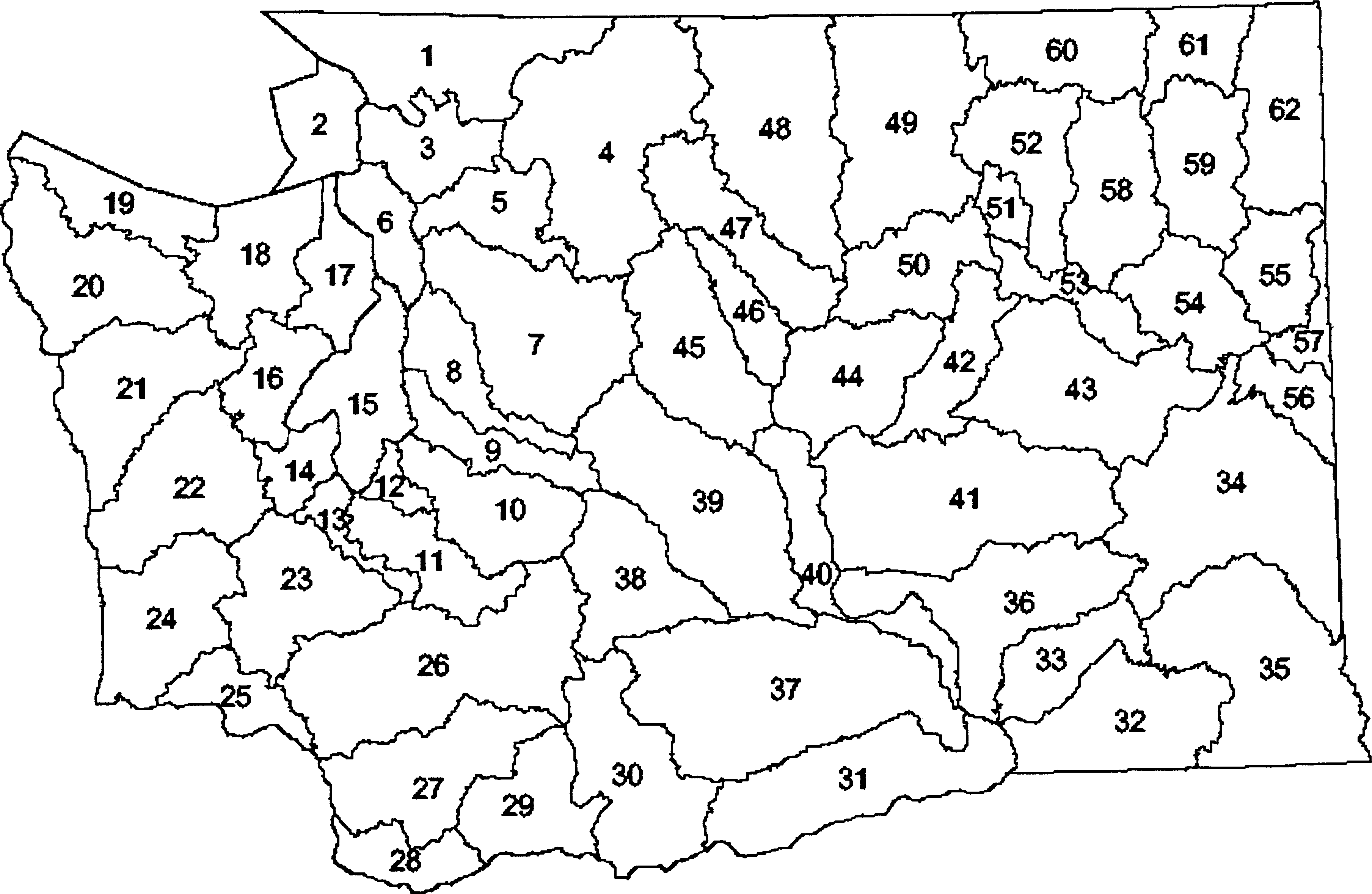 |
Key: | |||
1. Nooksack | 21. Queets/Quinault | 41. Lower Crab | 61. Upper Lake Roosevelt |
2. San Juan | 22. Lower Chehalis | 42. Grand Coulee | 62. Pend Oreille |
3. Lower Skagit/Samish | 23. Upper Chehalis | 43. Upper Crab/Wilson | |
4. Upper Skagit | 24. Willapa | 44. Moses Coulee | |
5. Stillaguamish | 25. Grays/Elochoman | 45. Wenatchee | |
6. Island | 26. Cowlitz | 46. Entiat | |
7. Snohomish | 27. Lewis | 47. Chelan | |
8. Cedar/Sammamish | 28. Salmon/Washougal | 48. Methow | |
9. Duwamish/Green | 29. Wind/White Salmon | 49. Okanogan | |
10. Puyallup/White | 30. Klickitat | 50. Foster | |
11. Nisqually | 31. Rock/Glade | 51. Nespelem | |
12. Chambers/Clover | 32. Walla | 52. Sandpile | |
13. Deschutes | 33. Lower Snake | 53. Lower Lake Roosevelt | |
14. Kennedy/Goldsborough | 34. Palouse | 54. Lower Spokane | |
15. Kitsap | 35. Middle Snake | 55. Little Spokane | |
16. Skokomish/ Dosewallips | 36. Esquatzel Coulee | 56. Hangman | |
17. Quilcene/Snow | 37. Lower Yakima | 57. Middle Spokane | |
18. Elwha/Dungeness | 38. Naches | 58. Middle Lake Roosevelt | |
19. Lyre/Hoko | 39. Upper Yakima | 59. Colville | |
20. Soleduck/Hoh | 40. Alkaki/Squilchuck | 60. Kettle | |
Table 602: Columbia River | Aquatic Life Uses | Recreation Uses | Water Supply Uses | Misc. Uses | Additional info for waterbody |
Columbia River: From mouth (latitude 46.2502, longitude -124.0829) to the Washington-Oregon border (latitude 46.0002, longitude -118.9809).1 | Spawning/Rearing | Primary Contact | All | All | - |
Columbia River: From Washington-Oregon border (latitude 46.0002, longitude -118.9809) to Grand Coulee Dam (latitude 47.957, longitude -118.9825).2,3 | Spawning/Rearing | Primary Contact | All | All | 173-201A-200 (1)(c)(iv) |
Columbia River: From Grand Coulee Dam (latitude 47.957, longitude -118.9825) to Canadian border (latitude 49.007, longitude -117.6313). | Core Summer Habitat | Primary Contact | All | All | - |
Notes for Columbia River: | ||
1. | Temperature shall not exceed a 1-day maximum (1-DMax) of 20.0°C due to human activities. When natural conditions exceed a 1-DMax of 20.0°C, no temperature increase will be allowed which will raise the receiving water temperature by greater than 0.3°C; nor shall such temperature increases, at any time, exceed 0.3°C due to any single source or 1.1°C due to all such activities combined. Dissolved oxygen shall exceed 90 percent of saturation. Special condition - Special fish passage exemption as described in WAC 173-201A-200 (1)(f). | |
2. | From Washington-Oregon border (latitude 46.0002, longitude -118.9809) to Priest Rapids Dam (latitude 46.6443, longitude -119.9103). Temperature shall not exceed a 1-DMax of 20.0°C due to human activities. When natural conditions exceed a 1-DMax of 20.0°C, no temperature increase will be allowed which will raise the receiving water temperature by greater than 0.3°C; nor shall such temperature increases, at any time, exceed t = 34/(T + 9). | |
3. | From Washington-Oregon border (latitude 46.0002, longitude -118.9809) to Grand Coulee Dam (latitude 47.957, longitude -118.9825). Special condition - Special fish passage exemption as described in WAC 173-201A-200 (1)(f). | |
4. | This WRIA contains waters requiring supplemental spawning and incubation protection for salmonid species per WAC 173-201A-200 (1)(c)(iv). See ecology publication 06-10-038 for further information. | |
Table 602: WRIA 1 - Nooksack | Aquatic Life Uses | Recreation Uses | Water Supply Uses | Misc. Uses | Additional info for waterbody |
Bertrand Creek: Upstream from the mouth (latitude 48.9121, longitude -122.5352) to Canadian border. | Core Summer Habitat | Primary Contact | All | All | 173-201A-200 (1)(c)(iv) |
Breckenridge Creek: Upstream from the mouth (latitude 48.9267, longitude -122.3129), including tributaries. | Core Summer Habitat | Primary Contact | All | All | - |
Chilliwack River and Little Chilliwack River: All waters above the confluence (latitude 48.9929, longitude -121.4086), including tributaries. | Char Spawning/Rearing | Primary Contact | All | All | - |
Chuckanut Creek: Upstream from the mouth (latitude 48.7002, longitude -122.4949) to headwaters. | Core Summer Habitat | Primary Contact | All | All | 173-201A-200 (1)(c)(iv) |
Colony Creek: Upstream from the mouth (latitude 48.5966, longitude -122.4193) to headwaters, including tributaries. | Core Summer Habitat | Primary Contact | All | All | - |
Dakota Creek: Upstream from the mouth (latitude 48.9721, longitude -122.7291), including tributaries. | Core Summer Habitat | Primary Contact | All | All | 173-201A-200 (1)(c)(iv) |
Dale Creek: Upstream from the mouth (latitude 48.8938, longitude -122.3023). | Core Summer Habitat | Primary Contact | All | All | - |
Deer Creek (tributary to Barrett Lake): Upstream from the mouth (latitude 48.8471, longitude -122.5615), including tributaries. | Core Summer Habitat | Primary Contact | All | All | 173-201A-200 (1)(c)(iv) |
Depot Creek: Upstream from the mouth (latitude 49.0296, longitude -121.4021), including tributaries. | Char Spawning/Rearing | Primary Contact | All | All | - |
Fishtrap Creek: Upstream from the mouth (latitude 48.912, longitude -122.5229) to Canadian border. | Core Summer Habitat | Primary Contact | All | All | 173-201A-200 (1)(c)(iv) |
Hutchinson Creek: Upstream from the mouth (latitude 48.7078, longitude -122.1812), including tributaries. | Char Spawning/Rearing | Primary Contact | All | All | 173-201A-200 (1)(c)(iv) |
Johnson Creek's unnamed tributary: Upstream from the mouth (latitude 48.978, longitude -122.3223) just north of Pangborn Road. | Core Summer Habitat | Primary Contact | All | All | - |
Nooksack River mainstem: Upstream from the mouth to the confluence with Anderson Creek (latitude 48.8646, longitude -122.3157). | Core Summer Habitat | Primary Contact | All | All | 173-201A-200 (1)(c)(iv) |
Nooksack River: Upstream from, and including, Anderson Creek (latitude 48.8646, longitude -122.3157) to the confluence with South Fork (latitude 48.8094, longitude -122.2039) except where otherwise designated char, including tributaries. | Core Summer Habitat | Primary Contact | All | All | 173-201A-200 (1)(c)(iv) |
Nooksack River, North Fork: Upstream from the confluence with South Fork (latitude 48.8094, longitude -122.2039) upstream to the confluence with Maple Creek (latitude 48.9119, longitude -122.0792), including tributaries. | Core Summer Habitat | Primary Contact | All | All | 173-201A-200 (1)(c)(iv) |
Nooksack River, North Fork: Upstream from and including Maple Creek (latitude 48.9119, longitude -122.0792), including all tributaries. | Char Spawning/Rearing | Primary Contact | All | All | 173-201A-200 (1)(c)(iv) |
Nooksack River, Middle Fork: Upstream from the confluence with mainstem (latitude 48.8341, longitude -122.1549) to headwaters, including tributaries. | Char Spawning/Rearing | Primary Contact | All | All | 173-201A-200 (1)(c)(iv) |
Nooksack River, South Fork: Upstream from the mouth (latitude 48.8075, longitude -122.2024) to Skookum Creek (latitude 48.6701, longitude -122.1417). | Core Summer Habitat | Primary Contact | All | All | 173-201A-200 (1)(c)(iv) |
Nooksack River, South Fork: Upstream from Skookum Creek (latitude 48.6701, longitude -122.1417) to Fobes Creek (latitude 48.6237, longitude -122.1123). | Core Summer Habitat | Primary Contact | All | All | 173-201A-200 (1)(c)(iv) |
Nooksack River, South Fork: Upstream from the confluence with Fobes Creek (latitude 48.6237, longitude -122.1123), including tributaries. | Char Spawning/Rearing | Primary Contact | All | All | 173-201A-200 (1)(c)(iv) |
Padden Creek: Upstream from the mouth (latitude 48.7202, longitude -122.5073) to headwaters, including tributaries. | Core Summer Habitat | Primary Contact | All | All | - |
Pepin Creek: From the mouth (latitude 48.9417, longitude -122.4748) to Canadian border (latitude 49.0023, longitude -122.4738). | Core Summer Habitat | Primary Contact | All | All | 173-201A-200 (1)(c)(iv) |
Saar Creek: From the mouth (latitude 48.9818, longitude -122.2386) to headwaters. | Core Summer Habitat | Primary Contact | All | All | - |
Silesia Creek: South of Canadian border (latitude 48.9985, longitude -121.6125), including tributaries. | Char Spawning/Rearing | Primary Contact | All | All | - |
Skookum Creek: Upstream from the mouth (latitude 48.6702, longitude -122.1417), including tributaries. | Char Spawning/Rearing | Primary Contact | All | All | 173-201A-200 (1)(c)(iv) |
Squaw Creek: Upstream from the mouth (latitude 48.969, longitude -122.3291). | Core Summer Habitat | Primary Contact | All | All | - |
Squalicum Creek's unnamed tributary: Upstream from latitude 48.7862, longitude -122.4864 to headwaters. | Core Summer Habitat | Primary Contact | All | All | 173-201A-200 (1)(c)(iv) |
Stickney Creek (Slough) and Kamm Ditch: Upstream from the confluence with mainstem Nooksack River (latitude 48.938, longitude -122.441) to headwaters. | Core Summer Habitat | Primary Contact | All | All | - |
Sumas River: From the Canadian border (latitude 49.0024, longitude -122.2324) to headwaters (latitude 48.888, longitude -122.3087) except where designated otherwise. | Spawning /Rearing | Primary Contact | All | All | - |
Tenmile Creek: Upstream from the mouth (latitude 48.8559, longitude -122.5771) to Barrett Lake (latitude 48.8513, longitude -122.5718). | Core Summer Habitat | Primary Contact | All | All | - |
Tomyhoi Creek: From the Canadian border (latitude 48.9991, longitude -121.7318) to headwaters. | Char Spawning/Rearing | Primary Contact | All | All | - |
Whatcom Creek: Upstream from the mouth (latitude 48.7549, longitude -122.4824) to outlet of Lake Whatcom (latitude 48.7575, longitude -122.4226), including tributaries. | Core Summer Habitat | Primary Contact | All | All | 173-201A-200 (1)(c)(iv) |
Note for WRIA 1: | ||
1. | This WRIA contains waters requiring supplemental spawning and incubation protection for salmonid species per WAC 173-201A-200 (1)(c)(iv). See ecology publication 06-10-038 for further information. | |
Table 602: WRIA 2 - San Juan | Aquatic Life Uses | Recreation Uses | Water Supply Uses | Misc. Uses | Additional info for waterbody |
There are no specific waterbody entries for this WRIA. | - | - | - | - | - |
Table 602: WRIA 3 - Lower Skagit-Samish | Aquatic Life Uses | Recreation Uses | Water Supply Uses | Misc. Uses | Additional info for waterbody |
Fisher and Carpenter creeks: Upstream from the mouth (latitude 48.3222, longitude -122.3363), including tributaries. | Core Summer Habitat | Primary Contact | All | All | - |
Hansen Creek: Upstream from the mouth (latitude 48.4902, longitude -122.2086), including tributaries. | Core Summer Habitat | Primary Contact | All | All | 173-201A-200 (1)(c)(iv) |
Nookachamps Creek: Upstream from the mouth (latitude 48.4709, longitude -122.2954) except where designated char, including tributaries. | Core Summer Habitat | Primary Contact | All | All | 173-201A-200 (1)(c)(iv) |
Nookachamps Creek, East Fork, and unnamed creek: Upstream from the confluence (latitude 48.4091, longitude -122.1702), including tributaries. | Char Spawning/Rearing | Primary Contact | All | All | - |
Samish River: Upstream from latitude 48.547, longitude -122.3373, including tributaries. | Core Summer Habitat | Primary Contact | All | All | 173-201A-200 (1)(c)(iv) |
Skagit River mainstem: Upstream from the mouth to Skiyou Slough-lower end (latitude 48.4974, longitude -122.1811). | Core Summer Habitat | Primary Contact | All | All | 173-201A-200 (1)(c)(iv) |
Skagit River, all tributaries to the mainstem: Upstream from the mouth to Skiyou Slough-lower end (latitude 48.4974, longitude -122.1811); except where designated otherwise. | Spawning /Rearing | Primary Contact | All | All | 173-201A-200 (1)(c)(iv) |
Skagit River: Upstream Skiyou Slough-lower end (latitude 48.4974, longitude -122.1811) to the boundary of WRIA 3 and 4 (latitude 48.5106, longitude -121.8973), except the other waters listed for this WRIA, including tributaries.1 | Core Summer Habitat | Primary Contact | All | All | 173-201A-200 (1)(c)(iv) |
Walker Creek and unnamed creek: Upstream of the confluence (latitude 48.3808, longitude -122.164), including tributaries. | Char Spawning/Rearing | Primary Contact | All | All | - |
Notes for WRIA 3: | ||
1. | Skagit River (Gorge bypass reach) from Gorge Dam (latitude 48.6978, longitude -121.2082) to Gorge Powerhouse (latitude 48.677, longitude -121.2422). Temperature shall not exceed a 1-DMax of 21°C due to human activities. When natural conditions exceed a 1-DMax of 21°C, no temperature increase will be allowed which will raise the receiving water temperature by greater than 0.3°C, nor shall such temperature increases, at any time, exceed t = 34/(T + 9). | |
2. | This WRIA contains waters requiring supplemental spawning and incubation protection for salmonid species per WAC 173-201A-200 (1)(c)(iv). See ecology publication 06-10-038 for further information. | |
Table 602: WRIA 4 - Upper Skagit | Aquatic Life Uses | Recreation Uses | Water Supply Uses | Misc. Uses | Additional info for waterbody |
Bacon Creek: Upstream from the mouth (latitude 48.5858, longitude -121.3934), including tributaries. | Char Spawning/Rearing | Primary Contact | All | All | 173-201A-200 (1)(c)(iv) |
Baker Lake: From dam (latitude 48.649, longitude -121.6906), including tributaries. | Char Spawning/Rearing | Primary Contact | All | All | 173-201A-200 (1)(c)(iv) |
Bear Creek and the unnamed outlet creek of Blue Lake: Upstream of the confluence (latitude 48.6204, longitude -121.7488), including tributaries. | Char Spawning/Rearing | Primary Contact | All | All | - |
Big Beaver Creek: Upstream from the mouth (latitude 48.7747, longitude -121.065), including tributaries. | Char Spawning/Rearing | Primary Contact | All | All | - |
Big Creek: Upstream from the mouth (latitude 48.3457, longitude -121.451), including tributaries. | Char Spawning/Rearing | Primary Contact | All | All | 173-201A-200 (1)(c)(iv) |
Buck Creek: Upstream from the mouth (latitude 48.2635, longitude -121.3374), including tributaries. | Char Spawning/Rearing | Primary Contact | All | All | 173-201A-200 (1)(c)(iv) |
Cascade River and Boulder Creek: All waters above the confluence (latitude 48.5177, longitude -121.3643), including tributaries. | Char Spawning/Rearing | Primary Contact | All | All | 173-201A-200 (1)(c)(iv); 173-201A-332 |
Circle Creek: Upstream from the mouth (latitude 48.2593, longitude -121.339), including tributaries. | Char Spawning/Rearing | Primary Contact | All | All | 173-201A-200 (1)(c)(iv) |
Clear Creek: Upstream from the mouth (latitude 48.2191, longitude -121.5684), including tributaries. | Char Spawning/Rearing | Primary Contact | All | All | 173-201A-200 (1)(c)(iv) |
Diobsud Creek and unnamed tributary: All waters above the confluence (latitude 48.5846, longitude -121.4422), including tributaries. | Char Spawning/Rearing | Primary Contact | All | All | - |
Goodell Creek: Upstream from the mouth (latitude 48.6725, longitude -121.2649), including tributaries. | Char Spawning/Rearing | Primary Contact | All | All | 173-201A-200 (1)(c)(iv) |
Hozomeen Creek: Upstream from the mouth (latitude 48.9869, longitude -121.0717), including tributaries. | Char Spawning/Rearing | Primary Contact | All | All | - |
Illabot Creek: Upstream from the mouth (latitude 48.49597, longitude -121.53164), including tributaries. | Char Spawning/Rearing | Primary Contact | All | All | 173-201A-200 (1)(c)(iv) |
Jordan Creek: Upstream from the mouth (latitude 48.5228, longitude -121.4229), including tributaries. | Char Spawning/Rearing | Primary Contact | All | All | 173-201A-200 (1)(c)(iv) |
Lightning Creek: Upstream from the mouth, including tributaries. | Char Spawning/Rearing | Primary Contact | All | All | - |
Little Beaver Creek: Upstream from the mouth (latitude 48.9162, longitude -121.0825), including tributaries. | Char Spawning/Rearing | Primary Contact | All | All | - |
Murphy Creek: Upstream from the mouth (latitude 48.191, longitude -121.5157), including tributaries. | Char Spawning/Rearing | Primary Contact | All | All | 173-201A-200 (1)(c)(iv) |
Newhalem Creek: Upstream from the mouth (latitude 48.6714, longitude -121.2561), including tributaries. | Char Spawning/Rearing | Primary Contact | All | All | 173-201A-200 (1)(c)(iv) |
Rocky Creek: Upstream from the mouth (latitude 48.6461, longitude -121.702), including tributaries. | Char Spawning/Rearing | Primary Contact | All | All | - |
Ruby Creek: Upstream from the mouth (latitude 48.7125, longitude -120.9868), including tributaries. | Char Spawning/Rearing | Primary Contact | All | All | - |
Sauk River and Dutch Creek: All waters above the confluence (latitude 48.1812, longitude -121.488), including tributaries. | Char Spawning/Rearing | Primary Contact | All | All | 173-201A-200 (1)(c)(iv) |
Silver Creek: Upstream from the mouth (latitude 48.9702, longitude -121.1039), including tributaries. | Char Spawning/Rearing | Primary Contact | All | All | - |
Skagit River: Upstream from latitude 48.5106, longitude -121.8973, including tributaries, except where listed otherwise for this WRIA.1 | Core Summer Habitat | Primary Contact | All | All | 173-201A-200 (1)(c)(iv) |
Stetattle Creek: Upstream from the mouth (latitude 48.7172, longitude -121.1498), including tributaries. | Char Spawning/Rearing | Primary Contact | All | All | - |
Straight Creek: Upstream from the mouth (latitude 48.2719, longitude -121.4004), including tributaries. | Char Spawning/Rearing | Primary Contact | All | All | 173-201A-200 (1)(c)(iv) |
Suiattle River: Above the confluence with Harriet Creek (latitude 48.2507, longitude -121.3018), including tributaries. | Char Spawning/Rearing | Primary Contact | All | All | 173-201A-200 (1)(c)(iv) |
Sulphur Creek: Upstream of the mouth (latitude 48.6482, longitude -121.6997), including tributaries. | Char Spawning/Rearing | Primary Contact | All | All | - |
Tenas Creek: Upstream of the mouth (latitude 48.3236, longitude -121.4395), including tributaries. | Char Spawning/Rearing | Primary Contact | All | All | 173-201A-200 (1)(c)(iv) |
Thunder Creek: Upstream of Lake Shannon (latitude 48.5978, longitude -121.7138), including tributaries. | Char Spawning/Rearing | Primary Contact | All | All | - |
Thunder Creek: Upstream of Diablo Lake (latitude 48.69469, longitude -121.09830), including tributaries. | Char Spawning/Rearing | Primary Contact | All | All | - |
White Chuck River: Upstream of the mouth (latitude 48.1729, longitude -121.4723), including tributaries. | Char Spawning/Rearing | Primary Contact | All | All | 173-201A-200 (1)(c)(iv) |
Notes for WRIA 4: | ||
1. | Skagit River (Gorge bypass reach) from the Gorge Dam (river mile 96.6) to the Gorge Powerhouse (river mile 94.2). Temperature shall not exceed a 1-DMax of 21°C due to human action. When natural conditions exceed a 1-DMax of 21°C, no temperature increase will be allowed which will raise the receiving water temperature by greater than 0.3°C, nor shall such temperature increases, at any time, exceed t = 34/(T + 9). | |
2. | This WRIA contains waters requiring supplemental spawning and incubation protection for salmonid species per WAC 173-201A-200 (1)(c)(iv). See ecology publication 06-10-038 for further information. | |
Table 602: WRIA 5 - Stillaguamish | Aquatic Life Uses | Recreation Uses | Water Supply Uses | Misc. Uses | Additional info for waterbody |
Brooks Creek and unnamed tributary: Upstream of the confluence (latitude 48.296, longitude -121.905), including tributaries. | Char Spawning/Rearing | Primary Contact | All | All | - |
Canyon Creek: Upstream of the confluence with unnamed tributary (latitude 48.1245, longitude -121.8892) to headwaters, including tributaries. | Char Spawning/Rearing | Primary Contact | All | All | 173-201A-200 (1)(c)(iv) |
Canyon Creek's unnamed tributaries: Upstream from latitude 48.1516, longitude -121.9677. | Char Spawning/Rearing | Primary Contact | All | All | - |
Unnamed tributaries: Upstream from the mouth of tributary (latitude 48.1463, longitude -121.9653) of unnamed tributary of Canyon Creek (latitude 48.12145, longitude -121.94482). | Char Spawning/Rearing | Primary Contact | All | All | - |
Crane Creek and unnamed tributary: Upstream of the confluence (latitude 48.3298, longitude -121.1005), including tributaries. | Char Spawning/Rearing | Primary Contact | All | All | - |
Crane Creek's unnamed tributaries: Upstream of the confluence (latitude 48.3324, longitude -122.1059), including tributaries. | Char Spawning/Rearing | Primary Contact | All | All | - |
Cub Creek and unnamed tributary: Upstream of the confluence (latitude 48.1677, longitude -121.9428), including tributaries. | Char Spawning/Rearing | Primary Contact | All | All | - |
Deer Creek (on N.F. Stillaguamish) and unnamed tributary: Upstream of the confluence (latitude 48.3194, longitude -121.9582), including tributaries. | Char Spawning/Rearing | Primary Contact | All | All | - |
Dicks Creek and unnamed outlet of Myrtle Lake: Upstream of the confluence (latitude 48.3185, longitude -121.8147), including tributaries. | Char Spawning/Rearing | Primary Contact | All | All | - |
Jim Creek and Little Jim Creek: Upstream of the confluence (latitude 48.1969, longitude -121.902), including tributaries. | Char Spawning/Rearing | Primary Contact | All | All | - |
Jorgenson Slough: Upstream from the confluence with Church Creek (latitude 48.2341, longitude -122.3235), between West Pass and Hat Slough, including tributaries. | Core Summer Habitat | Primary Contact | All | All | - |
Lake Cavanaugh and all tributaries: All waters above the outlet (latitude 48.3126, longitude -121.9803). | Char Spawning/Rearing | Primary Contact | All | All | - |
Pilchuck Creek and Bear Creek: Upstream of the confluence (latitude 48.3444, longitude -122.0691), including tributaries. | Char Spawning/Rearing | Primary Contact | All | All | - |
Pilchuck Creek's unnamed tributaries: Upstream of the confluence (latitude 48.309, longitude -122.1303), including tributaries. | Char Spawning/Rearing | Primary Contact | All | All | - |
Pilchuck Creek: Upstream from latitude 48.2395, longitude -122.2015 (above 268th St) to headwaters, including tributaries (except where designated char). | Core Summer Habitat | Primary Contact | All | All | 173-201A-200 (1)(c)(iv) |
Unnamed tributary to Portage Creek: Upstream of the confluence (latitude 48.1836, longitude -122.2314), including tributaries. | Core Summer Habitat | Primary Contact | All | All | 173-201A-200 (1)(c)(iv) |
Stillaguamish River: Upstream from the mouth (latitude 48.2082, longitude -122.323) to confluence of north and south forks (latitude 48.2036, longitude -122.1279). | Spawning/Rearing | Primary Contact | All | All | 173-201A-200 (1)(c)(iv) |
Stillaguamish River, North Fork: Upstream from the mouth (latitude 48.2039, longitude -122.128) to Boulder River (latitude 48.2822, longitude -121.7876), including tributaries (except where designated char). | Core Summer Habitat | Primary Contact | All | All | 173-201A-200 (1)(c)(iv) |
Stillaguamish River, North Fork, and Boulder River: Upstream from the confluence (latitude 48.2822, longitude -121.7876) to Squire Creek (latitude 48.2802, longitude -121.686), and downstream of the Mt. Baker Snoqualmie National Forest, including tributaries. | Char Spawning/Rearing | Primary Contact | All | All | 173-201A-200 (1)(c)(iv) |
Stillaguamish River, North Fork, and Boulder River: Upstream from the confluence (latitude 48.2802, longitude -121.686) up to Squire Creek (latitude 48.2802, longitude -121.686) that are in or above the Mt. Baker Snoqualmie National Forest, including tributaries. | Char Spawning/Rearing | Primary Contact | All | All | 173-201A-200 (1)(c)(iv) |
Stillaguamish River, North Fork: Upstream from the confluence with Squire Creek (latitude 48.2802, longitude -121.686) to headwaters, including all tributaries. | Char Spawning/Rearing | Primary Contact | All | All | 173-201A-200 (1)(c)(iv) |
Stillaguamish River, South Fork: Upstream from the mouth (latitude 48.2034, longitude -122.1277) to Canyon Creek (latitude 48.0972, longitude -121.9711). | Core Summer Habitat | Primary Contact | All | All | 173-201A-200 (1)(c)(iv) |
Stillaguamish River, South Fork: Upstream from Canyon Creek (latitude 48.0972, longitude -121.9711) to the unnamed tributary at latitude 48.092 longitude -121.8812 (near Cranberry Creek). | Core Summer Habitat | Primary Contact | All | All | 173-201A-200 (1)(c)(iv) |
Stillaguamish River, South Fork, and the unnamed tributary: Upstream of the confluence (latitude 48.092, longitude -121.8812) near Cranberry Creek, including tributaries. | Char Spawning/Rearing | Primary Contact | All | All | 173-201A-200 (1)(c)(iv) |
Note for WRIA 5: | ||
1. | This WRIA contains waters requiring supplemental spawning and incubation protection for salmonid species per WAC 173-201A-200 (1)(c)(iv). See ecology publication 06-10-038 for further information. | |
Table 602: WRIA 6 - Island | Aquatic Life Uses | Recreation Uses | Water Supply Uses | Misc. Uses | Additional info for waterbody |
There are no specific waterbody entries for this WRIA. | - | - | - | - | - |
Table 602: WRIA 7 - Snohomish | Aquatic Life Uses | Recreation Uses | Water Supply Uses | Misc. Uses | Additional info for waterbody |
Cherry Creek: Upstream from the mouth (latitude 47.7684, longitude -121.9603) to headwaters, including tributaries. | Core Summer Habitat | Primary Contact | All | All | 173-201A-200 (1)(c)(iv) |
Cripple Creek: Upstream from the mouth (latitude 47.523, longitude -121.4728), including tributaries. | Char Spawning/Rearing | Primary Contact | All | All | - |
Kelly Creek: Upstream from the mouth (latitude 47.9849, longitude -121.5034), including tributaries. | Char Spawning/Rearing | Primary Contact | All | All | - |
Miller River, East Fork, and West Fork Miller River: Upstream of the confluence (latitude 47.675, longitude -121.3892), including tributaries. | Char Spawning/Rearing | Primary Contact | All | All | 173-201A-200 (1)(c)(iv) |
North Fork Creek and unnamed creek: Upstream of the confluence (latitude 47.7406, longitude -121.8246), including tributaries. | Char Spawning/Rearing | Primary Contact | All | All | - |
Pilchuck River: Upstream from the mouth (latitude 47.9006, longitude -122.0919) to the confluence with Boulder Creek (latitude 48.0248, longitude -121.8217). | Core Summer Habitat | Primary Contact | All | All | 173-201A-200 (1)(c)(iv) |
Pilchuck River and Boulder Creek: Upstream on the confluence (latitude 48.0248, longitude -121.8217), including tributaries. | Char Spawning/Rearing | Primary Contact | All | All | 173-201A-200 (1)(c)(iv) |
Pratt River: Upstream from the mouth (latitude 47.5261, longitude -121.5873), including tributaries. | Char Spawning/Rearing | Primary Contact | All | All | - |
Skykomish River: Upstream from the mouth (latitude 47.8213, longitude -122.0327) to May Creek (above Gold Bar at latitude 47.8471, longitude -121.6954), including tributaries. | Core Summer Habitat | Primary Contact | All | All | 173-201A-200 (1)(c)(iv) |
Skykomish River and May Creek: Upstream from the confluence above Gold Bar at latitude 47.8471, longitude -121.6954, including tributaries (except where designated char). | Core Summer Habitat | Primary Contact | All | All | 173-201A-200 (1)(c)(iv) |
Skykomish River, North Fork: Upstream from below Salmon Creek at latitude 47.8790, longitude -121.4594 to headwaters, including tributaries. | Char Spawning/Rearing | Primary Contact | All | All | 173-201A-200 (1)(c)(iv) |
Skykomish River, South Fork, and Beckler River: Upstream from the confluence (latitude 47.715, longitude -121.3398), including tributaries. | Char Spawning/Rearing | Primary Contact | All | All | 173-201A-200 (1)(c)(iv) |
Snohomish River: Upstream from the mouth (latitude 48.0202, longitude -122.1989) to the southern tip of Ebey Island (latitude 47.942, longitude -122.1719).1 | Spawning/Rearing | Primary Contact | All | All | - |
Snohomish River: Upstream the southern tip of Ebey Island (latitude 47.942, longitude -122.1719) to below Pilchuck Creek at (latitude 47.9005, longitude -122.0925). | Spawning/Rearing | Primary Contact | All | All | 173-201A-200 (1)(c)(iv) |
Snohomish River: Upstream from below Pilchuck Creek (latitude 47.9005, longitude -122.0925) to the confluence with Skykomish and Snoqualmie River (latitude 47.8212, longitude -122.0331). | Core Summer Habitat | Primary Contact | All | All | 173-201A-200 (1)(c)(iv) |
Snoqualmie River: Upstream from the mouth (latitude 47.8208, longitude -122.0321) to the confluence with Harris Creek (latitude 47.6772, longitude -121.9382). | Spawning/Rearing | Primary Contact | All | All | 173-201A-200 (1)(c)(iv) |
Snoqualmie River and Harris Creek: Upstream from the confluence (latitude 47.6772, longitude -121.9382) to west boundary of Twin Falls State Park on south fork (latitude 47.4525, longitude -121.7063). | Core Summer Habitat | Primary Contact | All | All | 173-201A-200 (1)(c)(iv) |
Snoqualmie River, South Fork: Upstream from the west boundary of Twin Falls State Park (latitude 47.4525, longitude -121.7063) to headwaters, including tributaries. | Core Summer Habitat | Primary Contact | All | All | - |
Snoqualmie River, North Fork: Upstream from the mouth (latitude 47.5203, longitude -121.7746) to Sunday Creek (latitude 47.6556, longitude -121.6419). | Core Summer Habitat | Primary Contact | All | All | - |
Snoqualmie River, North Fork, and Sunday Creek: Upstream of the confluence (latitude 47.6556, longitude -121.6419), including tributaries. | Char Spawning/Rearing | Primary Contact | All | All | - |
Snoqualmie River, Middle Fork: Upstream from the mouth (latitude 47.52, longitude -121.7767) to Dingford Creek at latitude 47.5156, longitude -121.4545 (except where designated char). | Core Summer Habitat | Primary Contact | All | All | - |
Snoqualmie River, Middle Fork, and Dingford Creek: Upstream of the confluence (latitude 47.5156, longitude -121.4545), including tributaries. | Char Spawning/Rearing | Primary Contact | All | All | - |
Snoqualmie River's Middle Fork's unnamed tributaries: Upstream of the mouth at latitude 47.539, longitude -121.5645. | Char Spawning/Rearing | Primary Contact | All | All | - |
Sultan River: Upstream from the mouth (latitude 47.8605, longitude -121.8206) to Chaplain Creek (latitude 47.9211, longitude -121.8033), including tributaries. | Core Summer Habitat | Primary Contact | All | All | 173-201A-200 (1)(c)(iv) |
Sultan River: From the confluence with Chaplain Creek (latitude 47.9211, longitude -121.8033) to headwaters, including tributaries.2 | Core Summer Habitat | Primary Contact | All | All | - |
Taylor River: Upstream from the mouth (latitude 47.5468, longitude -121.5355), including tributaries. | Char Spawning/Rearing | Primary Contact | All | All | - |
Tolt River, North Fork, and unnamed creek: Upstream from the confluence (latitude 47.718, longitude -121.7788), including tributaries. | Char Spawning/Rearing | Primary Contact | All | All | - |
Tolt River, South Fork: Upstream from the mouth (latitude 47.6957, longitude -121.8213) to the unnamed creek at latitude 47.6921, longitude -121.7408, including tributaries. | Core Summer Habitat | Primary Contact | All | All | 173-201A-200 (1)(c)(iv) |
Tolt River, South Fork, and unnamed creek: Upstream of the confluence (latitude 47.6921, longitude -121.7408), including tributaries.3 | Char Spawning/Rearing | Primary Contact | All | All | - |
Tolt River's South Fork's unnamed tributaries: Upstream of the mouth at latitude 47.6888, longitude -121.7869. | Char Spawning/Rearing | Primary Contact | All | All | - |
Trout Creek: Upstream from the mouth (latitude 47.8643, longitude -121.4877), including tributaries. | Char Spawning/Rearing | Primary Contact | All | All | 173-201A-200 (1)(c)(iv) |
Notes for WRIA 7: | ||
1. | Fecal coliform organism levels shall both not exceed a geometric mean value of 200 colonies/100 mL and not have more than 10 percent of the samples obtained for calculating the mean value exceeding 400 colonies/100 mL. | |
2. | No waste discharge will be permitted above city of Everett Diversion Dam (latitude 47.9599, longitude -121.7962). | |
3. | No waste discharge will be permitted for the South Fork Tolt River and tributaries from latitude 47.6957, longitude -121.8213 to headwaters. | |
4. | This WRIA contains waters requiring supplemental spawning and incubation protection for salmonid species per WAC 173-201A-200 (1)(c)(iv). See ecology publication 06-10-038 for further information. | |
Table 602: WRIA 8 - Cedar-Sammamish | Aquatic Life Uses | Recreation Uses | Water Supply Uses | Misc. Uses | Additional info for waterbody |
Cedar River: Upstream from the confluence with Lake Washington (latitude 47.5005, longitude -122.2159) to the Maplewood Bridge (latitude 47.4693, longitude -122.1596). | Core Summer Habitat | Primary Contact | All | All | 173-201A-200 (1)(c)(iv) |
Cedar River: Upstream from the Maplewood Bridge (latitude 47.4693, longitude -122.1596) to Landsburg Dam (latitude 47.3759, longitude -121.9615), including tributaries. | Core Summer Habitat | Primary Contact | All | All | 173-201A-200 (1)(c)(iv) |
Cedar River: From Landsburg Dam (latitude 47.3759, longitude -121.9615) to Chester Morse Lake (latitude 47.4121, longitude -121.7526), including tributaries.1 | Core Summer Habitat | Primary Contact | All | All | 173-201A-200 (1)(c)(iv) |
Cedar River at Chester Morse Lake Cedar Falls Dam: All waters above the dam (latitude 47.4121, longitude -121.7526) to headwaters, including tributaries.2 | Char Spawning/Rearing | Primary Contact | All | All | - |
Holder Creek and unnamed tributary: Upstream from the confluence (latitude 47.4576, longitude -121.9505), including tributaries. | Char Spawning/Rearing | Primary Contact | All | All | - |
Issaquah Creek: Upstream from the confluence with Lake Sammamish (latitude 47.562, longitude -122.0651) to headwaters, including tributaries (except where designated char). | Core Summer Habitat | Primary Contact | All | All | 173-201A-200 (1)(c)(iv) |
Lake Washington Ship Canal: From Government Locks (latitude 47.6652, longitude -122.3973) to Lake Washington (latitude 47.6471, longitude -122.3003).3,4 | Core Summer Habitat | Primary Contact | All | All | - |
Notes for WRIA 8: | ||
1. | No waste discharge will be permitted. | |
2. | No waste discharge will be permitted. | |
3. | Salinity shall not exceed one part per thousand (1.0 ppt) at any point or depth along a line that transects the ship canal at the University Bridge (latitude 47.65284, longitude -122.32029). | |
4. | This waterbody is to be treated as a lake for purposes of applying this chapter. | |
5. | This WRIA contains waters requiring supplemental spawning and incubation protection for salmonid species per WAC 173-201A-200 (1)(c)(iv). See ecology publication 06-10-038 for further information. | |
Table 602: WRIA 9 - Duwamish-Green | Aquatic Life Uses | Recreation Uses | Water Supply Uses | Misc. Uses | Additional info for waterbody |
Duwamish River: From mouth south of a line bearing 254° true from the NW corner of berth 3, terminal No. 37 to the Black River (latitude 47.4737, longitude -122.2521) (Duwamish River continues as the Green River above the Black River). | Rearing/Migration Only | Primary Contact | All, Except Domestic Water | All | - |
Green River: From and including the Black River (latitude 47.4737, longitude -122.2521, and point where Duwamish River continues as the Green River) to latitude 47.3699, longitude -122.246 above confluence with Mill Creek. | Spawning/Rearing | Primary Contact | All | All | - |
Green River: Upstream from above confluence with Mill Creek at latitude 47.3699, longitude -122.2461 (east of the West Valley highway) to west boundary of Flaming Geyser State Park, including tributaries. | Core Summer Habitat | Primary Contact | All | All | 173-201A-200 (1)(c)(iv) |
Green River: Upstream from the west boundary of Flaming Geyser State Park (latitude 47.2805, longitude -122.0379) to headwaters, including tributaries (except where designated char and core). | Core Summer Habitat | Primary Contact | All | All | 173-201A-200 (1)(c)(iv) |
Green River and Sunday Creek: Upstream from the confluence (latitude 47.2164, longitude -121.4494), including tributaries.1 | Char Spawning/Rearing | Primary Contact | All | All | 173-201A-200 (1)(c)(iv) |
Smay Creek and West Fork Smay Creek: Upstream from the confluence, (latitude 47.2458, longitude -121.592) including tributaries.1 | Char Spawning/Rearing | Primary Contact | All | All | - |
Notes for WRIA 9: | ||
1. | No waste discharge will be permitted for the Green River and tributaries (King County) from west boundary of Sec. 13-T21N-R7E (river mile 59.1) to headwaters. | |
2. | This WRIA contains waters requiring supplemental spawning and incubation protection for salmonid species per WAC 173-201A-200 (1)(c)(iv). See ecology publication 06-10-038 for further information. | |
Table 602: WRIA 10 - Puyallup-White | Aquatic Life Uses | Recreation Uses | Water Supply Uses | Misc. Uses | Additional info for waterbody |
Carbon River: Waters above latitude 47.0001, longitude -121.9796, downstream of the Snoqualmie National Forest or Mt. Rainier National Park, including tributaries. | Char Spawning/Rearing | Primary Contact | All | All | 173-201A-200 (1)(c)(iv) |
Carbon River: Waters upstream from latitude 47.0001, longitude -121.9796 that are in or above the Snoqualmie National Forest or Mt. Rainier National Park, including tributaries. | Char Spawning/Rearing | Primary Contact | All | All | 173-201A-200 (1)(c)(iv) |
Clarks Creek: Upstream from the mouth (latitude 47.2137, longitude -122.3415), including tributaries. | Core Summer Habitat | Primary Contact | All | All | 173-201A-200 (1)(c)(iv) |
Clear Creek: Upstream from the mouth (latitude 47.2342, longitude -122.3942), including tributaries. | Core Summer Habitat | Primary Contact | All | All | - |
Clearwater River and Milky Creek: Upstream from the confluence (latitude 47.0978, longitude -121.7835), including tributaries. | Char Spawning/Rearing | Primary Contact | All | All | - |
Greenwater River: Upstream from the confluence with White River (latitude 47.1586, longitude -121.6596) to headwaters, including all tributaries. | Char Spawning/Rearing | Primary Contact | All | All | 173-201A-200 (1)(c)(iv) |
Puyallup River: Upstream from the mouth (latitude 47.2685, longitude -122.4269) to river mile 1.0 (latitude 47.2562, longitude -122.4173).1 | Rearing/Migration Only | Primary Contact | All, Except Domestic Water | All | - |
Puyallup River: Upstream from river mile 1.0 (latitude 47.2562, longitude -122.4173) to the confluence with White River (latitude 47.1999, longitude -122.2591).1 | Core Summer Habitat | Primary Contact | All | All | - |
Puyallup River: Upstream from the confluence with White River (latitude 47.1999, longitude -122.2591) to Mowich River (latitude 46.9005, longitude -122.031), including tributaries (except where designated char). | Core Summer Habitat | Primary Contact | All | All | 173-201A-200 (1)(c)(iv) |
Puyallup River at and including Mowich River: All waters upstream from the confluence (latitude 46.9005, longitude -122.031), including tributaries. | Char Spawning/Rearing | Primary Contact | All | All | 173-201A-200 (1)(c)(iv) |
South Prairie Creek: Upstream from the Kepka Fishing Pond (latitude 47.1197, longitude -122.0128), including tributaries, except those waters in or above the Snoqualmie National Forest. | Char Spawning/Rearing | Primary Contact | All | All | 173-201A-200 (1)(c)(iv) |
South Prairie Creek: Upstream from the Kepka Fishing Pond (latitude 47.1197, longitude -122.0128) in or above the Snoqualmie National Forest, including tributaries. | Char Spawning/Rearing | Primary Contact | All | All | - |
Swam Creek: Upstream from the mouth (latitude 47.2361, longitude -122.3928). | Core Summer Habitat | Primary Contact | All | All | - |
Voight Creek and Bear Creek: Upstream from the confluence (latitude 47.0493, longitude -122.1173) and downstream of the Snoqualmie National Forest or Mt. Rainier National Park, including tributaries. | Char Spawning/Rearing | Primary Contact | All | All | - |
Voight Creek and Bear Creek: Upstream from the confluence (latitude 47.0493, longitude -122.1173) and in or above the Snoqualmie National Forest or Mt. Rainier National Park, including tributaries. | Char Spawning/Rearing | Primary Contact | All | All | - |
White River: Upstream from the mouth (latitude 47.2001, longitude -122.2585) to latitude 47.2438, longitude -122.2422. | Spawning/Rearing | Primary Contact | All | All | - |
White River: Upstream from latitude 47.2438, longitude -122.2422 to Mud Mountain dam (latitude 47.1425, longitude -121.931), including tributaries. | Core Summer Habitat | Primary Contact | All | All | 173-201A-200 (1)(c)(iv) |
White River: Upstream from the Mud Mountain Dam (latitude 47.1425, longitude -121.931) to West Fork White River (latitude 47.1259, longitude -121.62), except where designated char. | Core Summer Habitat | Primary Contact | All | All | - |
White River and West Fork White River: Upstream from the confluence (latitude 47.1259, longitude -121.62), including tributaries. | Char Spawning/Rearing | Primary Contact | All | All | 173-201A-200 (1)(c)(iv) |
Wilkeson Creek and Gale Creek: Upstream from the confluence (latitude 47.0897, longitude -122.0171), including tributaries. | Char Spawning/Rearing | Primary Contact | All | All | 173-201A-200 (1)(c)(iv) |
Notes for WRIA 10: | ||
1. | The Puyallup Tribe regulates water quality from the mouth of the Puyallup River to the up-river boundary of the 1873 Survey Area of the Puyallup Reservation. | |
2. | This WRIA contains waters requiring supplemental spawning and incubation protection for salmonid species per WAC 173-201A-200 (1)(c)(iv). See ecology publication 06-10-038 for further information. | |
Table 602: WRIA 11 - Nisqually | Aquatic Life Uses | Recreation Uses | Water Supply Uses | Misc. Uses | Additional info for waterbody |
Big Creek: Upstream from the mouth (latitude 46.7424, longitude -122.0396), including tributaries. | Char Spawning/Rearing | Primary Contact | All | All | - |
Copper Creek: Upstream from the mouth (latitude 46.7542, longitude -121.9615), including tributaries. | Char Spawning/Rearing | Primary Contact | All | All | - |
East Creek: Upstream from the mouth (latitude 46.761, longitude -122.2078), including tributaries. | Char Spawning/Rearing | Primary Contact | All | All | - |
Horn Creek: Upstream from the mouth (latitude 46.9048, longitude -122.4945), including tributaries. | Spawning/Rearing | Primary Contact | All | All | 173-201A-200 (1)(c)(iv) |
Little Nisqually River: Upstream from the mouth (latitude 46.7945, longitude -122.3123), including tributaries. | Char Spawning/Rearing | Primary Contact | All | All | - |
Mashel River and Little Mashel River: Upstream from the confluence (latitude 46.8574, longitude -122.2802), including tributaries. | Char Spawning/Rearing | Primary Contact | All | All | 173-201A-200 (1)(c)(iv) |
Mineral Creek: Upstream from the mouth (latitude 46.7522, longitude -122.1462), including tributaries. | Char Spawning/Rearing | Primary Contact | All | All | - |
Muck Creek: Upstream from the mouth (latitude 46.9971, longitude -122.6293), including tributaries. | Core Summer Habitat | Primary Contact | All | All | - |
Murray Creek: Upstream from the mouth (latitude 46.9234, longitude -122.5269), including tributaries. | Spawning/Rearing | Primary Contact | All | All | 173-201A-200 (1)(c)(iv) |
Nisqually River mainstem: Upstream from the mouth (latitude 47.0858, longitude -122.7075) to Alder Dam (latitude 46.801, longitude -122.3106). | Core Summer Habitat | Primary Contact | All | All | - |
Nisqually River: Upstream from the Alder Dam (latitude 46.801, longitude -122.3106) to Tahoma Creek (latitude 46.7372, longitude -121.9022), including tributaries (except where designated char). | Core Summer Habitat | Primary Contact | All | All | 173-201A-200 (1)(c)(iv) |
Nisqually River and Tahoma Creek: Upstream from the confluence (latitude 46.7372, longitude -121.9022), including tributaries. | Char Spawning/Rearing | Primary Contact | All | All | - |
Rocky Slough: From latitude 46.8882, longitude -122.4339 to latitude 46.9109, longitude -122.4012. | Spawning/Rearing | Primary Contact | All | All | - |
Tanwax Creek: Upstream from the mouth (latitude 46.8636, longitude -122.4582) and downstream of lakes, including tributaries. | Spawning/Rearing | Primary Contact | All | All | 173-201A-200 (1)(c)(iv) |
Note for WRIA 11: | ||
1. | This WRIA contains waters requiring supplemental spawning and incubation protection for salmonid species per WAC 173-201A-200 (1)(c)(iv). See ecology publication 06-10-038 for further information. | |
Table 602: WRIA 12 - Chambers-Clover | Aquatic Life Uses | Recreation Uses | Water Supply Uses | Misc. Uses | Additional info for waterbody |
Clover Creek: Upstream from the inlet to Lake Steilacoom (latitude 47.1569, longitude -122.5287), including Spanaway Creek to the outlet of Spanaway Lake (latitude 47.1209, longitude -122.4464). | Spawning/Rearing | Primary Contact | All | All | - |
Table 602: WRIA 13 - Deschutes | Aquatic Life Uses | Recreation Uses | Water Supply Uses | Misc. Uses | Additional info for waterbody |
Deschutes River: Upstream from the mouth (latitude 47.0436, longitude -122.9091) to, and including, the tributary to Offutt Lake at latitude 46.9236, longitude -122.8123. | Spawning/Rearing | Primary Contact | All | All | - |
Deschutes River: Upstream of the tributary to Offutt Lake at latitude 46.9236, longitude -122.8123. All waters in or above the national forest boundary, including tributaries. | Core Summer Habitat | Primary Contact | All | All | - |
Deschutes River: Upstream of the tributary to Offutt Lake at latitude 46.9236, longitude -122.8123. All waters below the national forest boundary, including tributaries. | Core Summer Habitat | Primary Contact | All | All | - |
McLane Creek: Upstream from the mouth (latitude 47.0347, longitude -122.9904), including tributaries. | Core Summer Habitat | Primary Contact | All | All | - |
Table 602: WRIA 14 - Kennedy-Goldsborough | Aquatic Life Uses | Recreation Uses | Water Supply Uses | Misc. Uses | Additional info for waterbody |
Campbell Creek: Upstream from the mouth (latitude 47.2221, longitude -123.0252), including tributaries. | Core Summer Habitat | Primary Contact | All | All | - |
Coffee Creek: Upstream from the mouth (latitude 47.2093, longitude -123.1248), including tributaries. | Core Summer Habitat | Primary Contact | All | All | - |
Cranberry Creek: Upstream from the mouth (latitude 47.2625, longitude -123.0159), including tributaries. | Core Summer Habitat | Primary Contact | All | All | 173-201A-200 (1)(c)(iv) |
Deer Creek: Upstream from the mouth (latitude 47.2594, longitude -123.0094), including tributaries. | Core Summer Habitat | Primary Contact | All | All | 173-201A-200 (1)(c)(iv) |
Goldsborough Creek: Upstream from the mouth (latitude 47.2095, longitude -123.0952), including tributaries. | Core Summer Habitat | Primary Contact | All | All | - |
Hiawata Creek: Upstream from the mouth (latitude 47.2877, longitude -122.9204), including tributaries. | Spawning/Rearing | Primary Contact | All | All | - |
Jarrell Creek: Upstream from the mouth (latitude 47.2771, longitude -122.8909), including tributaries. | Spawning/Rearing | Primary Contact | All | All | - |
John's Creek: Upstream from the mouth (latitude 47.2461, longitude -123.043), including tributaries. | Core Summer Habitat | Primary Contact | All | All | 173-201A-200 (1)(c)(iv) |
Jones Creek: Upstream from the mouth (latitude 47.263, longitude -122.9321), including tributaries. | Spawning/Rearing | Primary Contact | All | All | - |
Malaney Creek: Upstream from the mouth (latitude 47.2514, longitude -123.0197). | Core Summer Habitat | Primary Contact | All | All | - |
Mill Creek: Upstream from the mouth (latitude 47.1955, longitude -122.9964), including tributaries. | Core Summer Habitat | Primary Contact | All | All | - |
Perry Creek: Upstream from the mouth (latitude 47.0492, longitude -123.0052), including tributaries. | Core Summer Habitat | Primary Contact | All | All | - |
Shelton Creek: Upstream from the mouth (latitude 47.2139, longitude -123.0952), including tributaries. | Core Summer Habitat | Primary Contact | All | All | - |
Uncle John Creek: Upstream from the mouth (latitude 47.2234, longitude -123.029), including tributaries. | Core Summer Habitat | Primary Contact | All | All | - |
Unnamed stream at Peale Passage inlet, on west side of Hartstene Island: Upstream from the mouth (latitude 47.2239, longitude -122.9135). | Spawning/Rearing | Primary Contact | All | All | - |
Note for WRIA 14: | ||
1. | This WRIA contains waters requiring supplemental spawning and incubation protection for salmonid species per WAC 173-201A-200 (1)(c)(iv). See ecology publication 06-10-038 for further information. | |
Table 602: WRIA 15 - Kitsap | Aquatic Life Uses | Recreation Uses | Water Supply Uses | Misc. Uses | Additional info for waterbody |
Anderson Creek: Upstream from the mouth (latitude 47.5278, longitude -122.6831), including tributaries. | Core Summer Habitat | Primary Contact | All | All | - |
Barker Creek: Upstream from Dyes Inlet (latitude 47.6378, longitude -122.6701) to Island Lake (latitude 47.6781, longitude -122.6603), including tributaries. | Core Summer Habitat | Primary Contact | All | All | - |
Blackjack Creek: Upstream from the mouth (latitude 47.5422, longitude -122.6272) and downstream of Square Lake (latitude 47.4826, longitude -122.6847), including tributaries. | Core Summer Habitat | Primary Contact | All | All | - |
Chico Creek: Above confluence with Kitsap Creek (latitude 47.5869, longitude -122.7127), including tributaries. | Core Summer Habitat | Primary Contact | All | All | - |
Clear Creek: Upstream from Dyes Inlet (latitude 47.6524, longitude -122.6863) to headwaters, including tributaries. | Core Summer Habitat | Primary Contact | All | All | - |
Gamble Creek: Upstream from the mouth (latitude 47.8116, longitude -122.5797), including tributaries. | Core Summer Habitat | Primary Contact | All | All | - |
Gorst Creek: Upstream from the mouth (latitude 47.5279, longitude -122.6979), including tributaries. | Core Summer Habitat | Primary Contact | All | All | - |
Martha John Creek: Upstream from the mouth (latitude 47.8263, longitude -122.5637), including tributaries. | Core Summer Habitat | Primary Contact | All | All | - |
Ross Creek: Upstream from the mouth (latitude 47.5387, longitude -122.6565), including tributaries. | Core Summer Habitat | Primary Contact | All | All | - |
Strawberry Creek: Upstream from the mouth (latitude 47.6459, longitude -122.6939), including tributaries. | Core Summer Habitat | Primary Contact | All | All | - |
Union River: From the Bremerton Waterworks Dam (latitude 47.5371, longitude -122.7796) to headwaters, including tributaries.1 | Core Summer Habitat | Primary Contact | All | All | - |
Unnamed tributary to Sinclair Inlet (between Gorst and Anderson Creeks): Upstream from the mouth (latitude 47.5270, longitude -122.6932). | Core Summer Habitat | Primary Contact | All | All | - |
Unnamed tributary to Sinclair Inlet, east of Blackjack Creek): Upstream from the mouth (latitude 47.5468, longitude -122.6131). | Spawning/Rearing | Primary Contact | All | All | - |
Unnamed tributary, west of Port Gamble Bay: Upstream from the mouth (latitude 47.8220, longitude -122.5831). | Core Summer Habitat | Primary Contact | All | All | - |
Notes for WRIA 15: | ||
1. | No waste discharge will be permitted. | |
2. | This WRIA contains waters requiring supplemental spawning and incubation protection for salmonid species per WAC 173-201A-200 (1)(c)(iv). See ecology publication 06-10-038 for further information. | |
Table 602: WRIA 16 - Skokomish-Dosewallips | Aquatic Life Uses | Recreation Uses | Water Supply Uses | Misc. Uses | Additional info for waterbody |
Dosewallips River: Upstream from the mouth (latitude 47.6852, longitude -122.8965), including tributaries. | Core Summer Habitat | Primary Contact | All | All | 173-201A-200 (1)(c)(iv) |
Duckabush River: Upstream from the mouth (latitude 47.6501, longitude -122.936), including tributaries. | Core Summer Habitat | Primary Contact | All | All | 173-201A-200 (1)(c)(iv) |
Hamma Hamma River: Upstream from the mouth (latitude 47.547, longitude -123.0453), including tributaries. | Core Summer Habitat | Primary Contact | All | All | 173-201A-200 (1)(c)(iv) |
Rock Creek and unnamed tributary: Upstream from the confluence (latitude 47.3894, longitude -123.3512), including tributaries. | Char Spawning/Rearing | Primary Contact | All | All | - |
Skokomish River: Upstream from the mouth (latitude 47.3294, longitude -123.1189), including tributaries, except where designated char. | Core Summer Habitat | Primary Contact | All | All | 173-201A-200 (1)(c)(iv) |
Skokomish River, North Fork: Upstream from latitude 47.416, longitude -123.2151 (below Cushman Upper Dam) to headwaters, including tributaries. | Char Spawning/Rearing | Primary Contact | All | All | - |
Skokomish River, South Fork, and Brown Creek: Upstream from the confluence (latitude 47.4113, longitude -123.3188), including tributaries. | Char Spawning/Rearing | Primary Contact | All | All | 173-201A-200 (1)(c)(iv) |
Vance Creek and Cabin Creek: Upstream from the confluence (latitude 47.3651, longitude -123.3837). | Char Spawning/Rearing | Primary Contact | All | All | - |
Note for WRIA 16: | ||
1. | This WRIA contains waters requiring supplemental spawning and incubation protection for salmonid species per WAC 173-201A-200 (1)(c)(iv). See ecology publication 06-10-038 for further information. | |
Table 602: WRIA 17 - Quilcene-Snow | Aquatic Life Uses | Recreation Uses | Water Supply Uses | Misc. Uses | Additional info for waterbody |
Big Quilcene River: Upstream from the mouth (latitude 47.8186, longitude -122.8618), including tributaries. | Core Summer Habitat | Primary Contact | All | All | 173-201A-200 (1)(c)(iv) |
Note for WRIA 17: | ||
1. | This WRIA contains waters requiring supplemental spawning and incubation protection for salmonid species per WAC 173-201A-200 (1)(c)(iv). See ecology publication 06-10-038 for further information. | |
Table 602: WRIA 18 - Elwha-Dungeness | Aquatic Life Uses | Recreation Uses | Water Supply Uses | Misc. Uses | Additional info for waterbody |
Boulder Creek and Deep Creek: Upstream from the confluence (latitude 47.9835, longitude -123.6441), including tributaries. | Char Spawning/Rearing | Primary Contact | All | All | - |
Dungeness River mainstem: Upstream from the mouth (latitude 48.1524, longitude -123.1294) to Canyon Creek (latitude 47.0254, longitude -123.137). | Core Summer Habitat | Primary Contact | All | All | 173-201A-200 (1)(c)(iv) |
Dungeness River, tributaries to mainstem: Above and between confluence with Matriotti Creek (latitude 48.1384, longitude -123.1349) to Canyon Creek (latitude 47.0254, longitude -123.137). | Spawning/Rearing | Primary Contact | All | All | 173-201A-200 (1)(c)(iv) |
Dungeness River and Canyon Creek: Upstream from the confluence (latitude 47.0254, longitude -123.137), including tributaries. | Char Spawning/Rearing | Primary Contact | All | All | 173-201A-200 (1)(c)(iv) |
Elwha River: Upstream from the mouth (latitude 48.1421, longitude -123.5646) to Cat Creek (latitude 47.9729, longitude -123.5919), including tributaries, except where designated char. | Core Summer Habitat | Primary Contact | All | All | 173-201A-200 (1)(c)(iv) |
Elwha River and Cat Creek: Upstream from the confluence (latitude 47.9729, longitude -123.5919), including tributaries. | Char Spawning/Rearing | Primary Contact | All | All | - |
Ennis Creek and White Creek: Upstream from the confluence with the Strait of Juan De Fuca (latitude 48.1172, longitude -123.4051) to the Olympic National Park Boundary, including tributaries. | Core Summer Habitat | Primary Contact | All | All | 173-201A-200 (1)(c)(iv) |
Ennis Creek: All waters lying above the Olympic National Park Boundary, including tributaries. | Core Summer Habitat | Primary Contact | All | All | - |
Griff Creek and unnamed tributary: All waters above the confluence (latitude 48.0134, longitude -123.5455), including tributaries. | Char Spawning/Rearing | Primary Contact | All | All | - |
Hughes Creek and unnamed tributary: All waters above the confluence (latitude 48.0297, longitude -123.6335), including tributaries. | Char Spawning/Rearing | Primary Contact | All | All | - |
Little River: Upstream from the mouth (latitude 48.063, longitude -123.5772), including tributaries. | Char Spawning/Rearing | Primary Contact | All | All | - |
Matriotti Creek: Upstream from the mouth (latitude 48.1385, longitude -123.1352). | Core Summer Habitat | Primary Contact | All | All | 173-201A-200 (1)(c)(iv) |
Wolf Creek and unnamed tributary: All waters above the confluence (latitude 47.9652, longitude -123.5386), including tributaries. | Char Spawning/Rearing | Primary Contact | All | All | - |
Note for WRIA 18: | ||
1. | This WRIA contains waters requiring supplemental spawning and incubation protection for salmonid species per WAC 173-201A-200 (1)(c)(iv). See ecology publication 06-10-038 for further information. | |
Table 602: WRIA 19 - Lyre-Hoko | Aquatic Life Uses | Recreation Uses | Water Supply Uses | Misc. Uses | Additional info for waterbody |
There are no specific waterbody entries for this WRIA. | - | - | - | - | - |
Table 602: WRIA 20 - Sol Duc | Aquatic Life Uses | Recreation Uses | Water Supply Uses | Misc. Uses | Additional info for waterbody |
Dickey River: Upstream from the mouth (latitude 47.9208, longitude -124.6209), including tributaries. | Core Summer Habitat | Primary Contact | All | All | 173-201A-200 (1)(c)(iv) |
Hoh River: Upstream from the mouth (latitude 47.749, longitude -124.429) to the confluence with the South Fork Hoh River (latitude 47.8182, longitude -124.0207). | Core Summer Habitat | Primary Contact | All | All | 173-201A-200 (1)(c)(iv) |
Hoh River and South Fork Hoh River: All waters above the confluence (latitude 47.8182, longitude -124.0207). | Char Spawning/Rearing | Primary Contact | All | All | 173-201A-200 (1)(c)(iv) |
Quillayute and Bogachiel rivers: Upstream from the mouth (latitude 47.9198, longitude -124.633). | Core Summer Habitat | Primary Contact | All | All | 173-201A-200 (1)(c)(iv) |
Sol Duc River: Upstream from the mouth (latitude 47.9147, longitude -124.542) to Canyon Creek (latitude 47.9513, longitude -123.8271), including tributaries. | Core Summer Habitat | Primary Contact | All | All | 173-201A-200 (1)(c)(iv) |
Sol Duc River: Upstream from the confluence with Canyon Creek (latitude 47.9513, longitude -123.8271), including tributaries. | Char Spawning/Rearing | Primary Contact | All | All | 173-201A-200 (1)(c)(iv) |
Note for WRIA 20: | ||
1. | This WRIA contains waters requiring supplemental spawning and incubation protection for salmonid species per WAC 173-201A-200 (1)(c)(iv). See ecology publication 06-10-038 for further information. | |
Table 602: WRIA 21 - Queets-Quinault | Aquatic Life Uses | Recreation Uses | Water Supply Uses | Misc. Uses | Additional info for waterbody |
Clearwater River and unnamed tributary: All waters above the confluence (latitude 47.7272, longitude -124.0365), including tributaries. | Char Spawning/Rearing | Primary Contact | All | All | - |
Kunamakst Creek and unnamed tributary: All waters above the confluence (latitude 47.7284, longitude -124.0793), including tributaries. | Char Spawning/Rearing | Primary Contact | All | All | - |
Matheny Creek and unnamed tributary: All waters above the confluence (latitude 47.5589, longitude -123.9548), including tributaries. | Char Spawning/Rearing | Primary Contact | All | All | - |
Queets River: Upstream from the mouth (latitude 47.535, longitude -124.3463) to Tshletshy Creek (latitude 47.6659, longitude -123.9277). | Core Summer Habitat | Primary Contact | All | All | 173-201A-200 (1)(c)(iv) |
Queets River: Upstream from the confluence with Tshletshy Creek (latitude 47.6659, longitude -123.9277). | Char Spawning/Rearing | Primary Contact | All | All | 173-201A-200 (1)(c)(iv) |
Quinault River: Upstream from the mouth (latitude 47.3488, longitude -124.2926) to the confluence with the North Fork Quinault River (latitude 47.5369, longitude -123.6718). | Core Summer Habitat | Primary Contact | All | All | 173-201A-200 (1)(c)(iv) |
Quinault River and North Fork Quinault: All waters above the confluence (latitude 47.5369, longitude -123.6718), including tributaries. | Char Spawning/Rearing | Primary Contact | All | All | 173-201A-200 (1)(c)(iv) |
Salmon River, Middle Fork, and unnamed tributary: All waters above the confluence (latitude 47.5206, longitude -123.9908), including tributaries. | Char Spawning/Rearing | Primary Contact | All | All | - |
Sams River and unnamed tributary: All waters above the confluence (latitude 47.6055, longitude -123.8939), including tributaries. | Char Spawning/Rearing | Primary Contact | All | All | - |
Solleks River and unnamed tributary: All waters above the confluence (latitude 47.694, longitude -124.0135), including tributaries. | Char Spawning/Rearing | Primary Contact | All | All | - |
Stequaleho Creek and unnamed tributary: All waters above the confluence (latitude 47.662, longitude -124.0439), including tributaries. | Char Spawning/Rearing | Primary Contact | All | All | - |
Tshletshy Creek and unnamed tributary: All waters above the confluence (latitude 47.6586, longitude -123.868), including tributaries. | Char Spawning/Rearing | Primary Contact | All | All | - |
Note for WRIA 21: | ||
1. | This WRIA contains waters requiring supplemental spawning and incubation protection for salmonid species per WAC 173-201A-200 (1)(c)(iv). See ecology publication 06-10-038 for further information. | |
Table 602: WRIA 22 - Lower Chehalis | Aquatic Life Uses | Recreation Uses | Water Supply Uses | Misc. Uses | Additional info for waterbody |
Andrews Creek: Upstream from the confluence with West Fork (latitude 46.823, longitude -124.0234), including tributaries. | Core Summer Habitat | Primary Contact | All | All | 173-201A-200 (1)(c)(iv) |
Baker Creek and unnamed tributary: All waters above the confluence (latitude 47.3302, longitude -123.4142), including tributaries. | Char Spawning/Rearing | Primary Contact | All | All | - |
Big Creek and Middle Fork Big Creek: All waters above the confluence (latitude 47.4041, longitude -123.6583), including tributaries. | Char Spawning/Rearing | Primary Contact | All | All | 173-201A-200 (1)(c)(iv) |
Canyon River and unnamed tributary: All waters above the confluence (latitude 47.3473, longitude -123.4949), including tributaries. | Char Spawning/Rearing | Primary Contact | All | All | - |
Chehalis River: From upper boundary of Grays Harbor at Cosmopolis (latitude 46.9579, longitude -123.7625) to latitude 46.6004, longitude -123.1472 on main stem and to latitude 46.6013, longitude -123.1253 on South Fork. | Spawning/Rearing | Primary Contact | All | All | 173-201A-200 (1)(c)(iv) |
Chester Creek and unnamed tributary: All waters above the confluence (latitude 47.4192, longitude -123.7856), including tributaries. | Char Spawning/Rearing | Primary Contact | All | All | - |
Cloquallum Creek: Upstream from the mouth (latitude 46.986, longitude -123.3951). | Core Summer Habitat | Primary Contact | All | All | 173-201A-200 (1)(c)(iv) |
Decker Creek: Upstream from the mouth (latitude 47.0964, longitude -123.4735). | Core Summer Habitat | Primary Contact | All | All | 173-201A-200 (1)(c)(iv) |
Delezene Creek: Upstream from the mouth (latitude 46.9413, longitude -123.3893). | Core Summer Habitat | Primary Contact | All | All | 173-201A-200 (1)(c)(iv) |
Elk River, West Branch: Upstream from latitude 46.8111, longitude -123.9774. | Core Summer Habitat | Primary Contact | All | All | 173-201A-200 (1)(c)(iv) |
Goforth Creek and unnamed tributary: All waters above the confluence (latitude 47.3559, longitude -123.7325), including tributaries. | Char Spawning/Rearing | Primary Contact | All | All | - |
Hoquiam River, East Fork: Upstream from the confluence with Lytle Creek (latitude 47.0523, longitude -123.8428), including tributaries. | Core Summer Habitat | Primary Contact | All | All | 173-201A-200 (1)(c)(iv) |
Hoquiam River: Upstream from latitude 47.0573, longitude -123.9278 (the approximate upper limit of tidal influence at Dekay Road Bridge), including tributaries. | Core Summer Habitat | Primary Contact | All | All | 173-201A-200 (1)(c)(iv) |
Hoquiam River, Middle Fork: Upstream from latitude 47.0418, longitude -123.9052, including tributaries. | Core Summer Habitat | Primary Contact | All | All | 173-201A-200 (1)(c)(iv) |
Hoquiam River mainstem (continues as west fork above east fork): Upstream from the mouth (latitude 46.9825, longitude -123.8781) to latitude 47.0573, longitude -123.9278 (the approximate upper limit of tidal influence at Dekay Road Bridge). | Rearing/Migration Only | Primary Contact | All, Except Domestic Water | All | 173-201A-200 (1)(c)(iv) |
Humptulips River: Upstream from the mouth (latitude 47.0413, longitude -124.0522) to latitude 47.0810, longitude -124.0655, including tributaries. | Spawning/Rearing | Primary Contact | All | All | - |
Humptulips River: Upstream from latitude 47.0810, longitude -124.0655 to Olympic National Forest boundary, including tributaries (except where designated char). | Core Summer Habitat | Primary Contact | All | All | - |
Humptulips River: Upstream from Olympic National Forest boundary to headwaters, including tributaries (except where designated char). | Core Summer Habitat | Primary Contact | All | All | 173-201A-200 (1)(c)(iv) |
Humptulips River, East Fork, and unnamed tributary: All waters above the confluence (latitude 47.3816, longitude -123.7175), including tributaries. | Char Spawning/Rearing | Primary Contact | All | All | 173-201A-200 (1)(c)(iv) |
Humptulips River, West Fork, and Petes Creek: All waters above the confluence (latitude 47.4487, longitude -123.7257), including tributaries. | Char Spawning/Rearing | Primary Contact | All | All | 173-201A-200 (1)(c)(iv) |
Johns River and North Fork Johns River: All waters above the confluence (latitude 46.8597, longitude -123.9049). | Core Summer Habitat | Primary Contact | All | All | 173-201A-200 (1)(c)(iv) |
Little Hoquiam River, North Fork: Upstream from latitude 47.0001, longitude -123.9269, including tributaries. | Core Summer Habitat | Primary Contact | All | All | 173-201A-200 (1)(c)(iv) |
Little Hoquiam River: Upstream from latitude 46.9934, longitude -123.9364, including tributaries. | Core Summer Habitat | Primary Contact | All | All | 173-201A-200 (1)(c)(iv) |
Mox Chehalis Creek: Upstream from latitude 46.9680, longitude -123.3083, including tributaries. | Core Summer Habitat | Primary Contact | All | All | 173-201A-200(1)(c)(iv) |
Newskah Creek: Upstream from latitude 46.9163, longitude -123.8235, including tributaries. | Core Summer Habitat | Primary Contact | All | All | 173-201A-200 (1)(c)(iv) |
Satsop River: Upstream from latitude 46.9828, longitude -123.4887 to headwaters, including tributaries (except where designated char). | Core Summer Habitat | Primary Contact | All | All | 173-201A-200 (1)(c)(iv) |
Satsop River, West Fork, and Robertson Creek: All waters above the confluence (latitude 47.3324, longitude -123.5557), including tributaries. | Char Spawning/Rearing | Primary Contact | All | All | - |
Satsop River, Middle Fork, and unnamed tributary: All waters above the confluence (latitude 47.3333, longitude -123.4463), including tributaries. | Char Spawning/Rearing | Primary Contact | All | All | - |
Wildcat Creek: Upstream from the confluence with Cloquallum Creek (latitude 47.0204, longitude -123.3619), including tributaries. | Core Summer Habitat | Primary Contact | All | All | 173-201A-200 (1)(c)(iv) |
Wishkah River, East Fork: Upstream from above latitude 47.0801, longitude -123.7560, including tributaries. | Core Summer Habitat | Primary Contact | All | All | 173-201A-200 (1)(c)(iv) |
Wishkah River: Upstream from the mouth (latitude 46.9739, longitude -123.8092) to river mile 6 (latitude 47.0337, longitude -123.8023). | Rearing/Migration Only | Primary Contact | All, Except Domestic Water | All | - |
Wishkah River: Upstream from river mile 6 (latitude 47.0337, longitude -123.8023) to latitude 47.1089, longitude -123.7908. | Spawning/Rearing | Primary Contact | All | All | - |
Wishkah River: From latitude 47.1089, longitude -123.7908 to confluence with West Fork (latitude 47.1227, longitude -123.7779), including tributaries. | Core Summer Habitat | Primary Contact | All | All | 173-201A-200 (1)(c)(iv) |
Wishkah River and West Fork: Upstream from the confluence (latitude 47.1227, longitude -123.7779) to headwaters, including tributaries.1 | Core Summer Habitat | Primary Contact | All | All | 173-201A-200 (1)(c)(iv) |
Wynoochee River: Upstream from latitude 46.9709, longitude -123.6252 (near railroad crossing) to Olympic National Forest boundary (latitude 47.3452, longitude -123.6452), including tributaries. | Core Summer Habitat | Primary Contact | All | All | 173-201A-200 (1)(c)(iv) |
Wynoochee River: Upstream from Olympic National Forest boundary (latitude 47.3452, longitude -123.6452) to Wynoochee Dam (latitude 47.3851, longitude -123.6055), including tributaries. | Core Summer Habitat | Primary Contact | All | All | 173-201A-200 (1)(c)(iv) |
Wynoochee River: Above Wynoochee Dam (latitude 47.3851, longitude -123.6055), including tributaries. | Char Spawning/Rearing | Primary Contact | All | All | 173-201A-200 (1)(c)(iv) |
Notes for WRIA 22: | ||
1. | No waste discharge will be permitted from south boundary of Sec. 33-T21N-R8W (river mile 32.0) to headwaters. | |
2. | This WRIA contains waters requiring supplemental spawning and incubation protection for salmonid species per WAC 173-201A-200 (1)(c)(iv). See ecology publication 06-10-038 for further information. | |
Table 602: WRIA 23 - Upper Chehalis | Aquatic Life Uses | Recreation Uses | Water Supply Uses | Misc. Uses | Additional info for waterbody |
Bunker Creek: Upstream from the mouth (latitude 46.6438, longitude -123.1092), including tributaries. | Core Summer Habitat | Primary Contact | All | All | 173-201A-200 (1)(c)(iv) |
Cedar Creek: Upstream from latitude 46.8795, longitude -123.2714 (near intersection with Highway 12), including tributaries. | Core Summer Habitat | Primary Contact | All | All | 173-201A-200 (1)(c)(iv) |
Chehalis River, South Fork: Upstream from latitude 46.6018, longitude -123.1251 (near junction with State Route 6), including tributaries (except where specifically designated char). | Core Summer Habitat | Primary Contact | All | All | 173-201A-200 (1)(c)(iv) |
Chehalis River: Upstream from latitude 46.6004, longitude -123.1473, including tributaries (except where specifically designated char). | Core Summer Habitat | Primary Contact | All | All | 173-201A-200 (1)(c)(iv) |
Chehalis River mainstem: Upstream from the upper boundary of Grays Harbor at Cosmopolis (latitude 46.95801, longitude -123.76252) to latitude 46.6004, longitude -123.1473 on main stem and to latitude 46.6018, longitude -123.125 on South Fork.1 | Spawning/Rearing | Primary Contact | All | All | 173-201A-200 (1)(c)(iv) |
Chehalis River, South Fork, and unnamed tributary: All waters above the confluence (latitude 46.4514, longitude -123.2919), including tributaries. | Char Spawning/Rearing | Primary Contact | All | All | 173-201A-200 (1)(c)(iv) |
Chehalis River, West Fork, and East Fork Chehalis River: All waters above the confluence (latitude 46.4514, longitude -123.2919), including tributaries. | Char Spawning/Rearing | Primary Contact | All | All | 173-201A-200 (1)(c)(iv) |
Coffee Creek: Upstream from the mouth (latitude 46.7313, longitude -122.9658), including tributaries. | Core Summer Habitat | Primary Contact | All | All | 173-201A-200 (1)(c)(iv) |
Eight Creek and unnamed tributary: All waters above the confluence (latitude 46.621, longitude -123.4137), including tributaries. | Char Spawning/Rearing | Primary Contact | All | All | 173-201A-200 (1)(c)(iv) |
Fall Creek and unnamed tributary: All waters above the confluence (latitude 46.7669, longitude -122.6741), including tributaries. | Char Spawning/Rearing | Primary Contact | All | All | - |
Garrard Creek, South Fork: Upstream from latitude 46.8013, longitude -123.3060, including tributaries. | Core Summer Habitat | Primary Contact | All | All | 173-201A-200 (1)(c)(iv) |
Hanaford Creek: Upstream from the mouth to (latitude 46.7604, longitude -122.8662), including tributaries.2 | Spawning/Rearing | Primary Contact | All | All | 173-201A-200 (1)(c)(iv) |
Hanaford Creek: Upstream from (latitude 46.7604, longitude -122.8662) to the unnamed tributary at latitude 46.7301, longitude -122.6829, including tributaries (except where designated char). | Spawning/Rearing | Primary Contact | All | All | 173-201A-200 (1)(c)(iv) |
Hanaford Creek and unnamed tributary: All waters above the confluence (latitude 46.7301, longitude -122.6829), including tributaries. | Char Spawning/Rearing | Primary Contact | All | All | - |
Kearney Creek and unnamed tributary: All waters above the confluence (latitude 46.6255, longitude -122.5699), including tributaries. | Char Spawning/Rearing | Primary Contact | All | All | - |
Laramie Creek and unnamed tributary: All waters above the confluence (latitude 46.7902, longitude -122.5914), including tributaries. | Char Spawning/Rearing | Primary Contact | All | All | - |
Lincoln Creek, North Fork: Upstream from latitude 46.7371, longitude -123.2462, including tributaries. | Core Summer Habitat | Primary Contact | All | All | 173-201A-200 (1)(c)(iv) |
Lincoln Creek, South Fork: Upstream from latitude 46.7253, longitude -123.2306, including tributaries. | Core Summer Habitat | Primary Contact | All | All | 173-201A-200 (1)(c)(iv) |
Mima Creek: Upstream from latitude 46.8588, longitude -123.0856, including tributaries. | Core Summer Habitat | Primary Contact | All | All | 173-201A-200 (1)(c)(iv) |
Newaukum River: Upstream from the mouth (latitude 46.6512, longitude -122.9815), including tributaries (except where designated char). | Core Summer Habitat | Primary Contact | All | All | 173-201A-200 (1)(c)(iv) |
Newaukum River, North Fork, and unnamed tributary: All waters above the confluence (latitude 46.6793, longitude -122.6685), including tributaries. | Char Spawning/Rearing | Primary Contact | All | All | 173-201A-200 (1)(c)(iv) |
Newaukum River, South Fork, and Frase Creek: All waters above the confluence (latitude 46.6234, longitude -122.6321), including tributaries. | Char Spawning/Rearing | Primary Contact | All | All | 173-201A-200(1)(c)(iv) |
Pheeny Creek and unnamed tributary: All waters above the confluence (latitude 46.7834, longitude -122.6291), including tributaries. | Char Spawning/Rearing | Primary Contact | All | All | - |
Porter Creek and Jamaica Day Creek: All waters above the confluence (latitude 46.9416, longitude -123.3011). | Core Summer Habitat | Primary Contact | All | All | 173-201A-200 (1)(c)(iv) |
Rock Creek (upstream of Callow): All waters above confluence with Chehalis River (latitude 46.8805, longitude -123.2946), except where designated otherwise in this table. | Core Summer Habitat | Primary Contact | All | All | 173-201A-200 (1)(c)(iv) |
Rock Creek (upstream of Pe Ell) and unnamed tributary: All waters above the confluence (latitude 46.5283, longitude -123.3791), including tributaries. | Char Spawning/Rearing | Primary Contact | All | All | - |
Scatter Creek: Upstream from latitude 46.8025, longitude -123.0863 (near mouth) to headwaters, including tributaries. | Core Summer Habitat | Primary Contact | All | All | 173-201A-200 (1)(c)(iv) |
Seven Creek and unnamed tributary: All waters above the confluence (latitude 46.6192, longitude -123.3736), including tributaries. | Char Spawning/Rearing | Primary Contact | All | All | - |
Skookumchuck River: Upstream from the confluence with Hanaford Creek (latitude 46.7446, longitude -122.9402) to headwaters, including tributaries (except where designated char). | Core Summer Habitat | Primary Contact | All | All | 173-201A-200 (1)(c)(iv) |
Skookumchuck River mainstem: Upstream from the mouth (latitude 46.7194, longitude -122.9803) to Hanaford Creek (latitude 46.7446, longitude -122.9402). | Core Summer Habitat | Primary Contact | All | All | 173-201A-200 (1)(c)(iv) |
Skookumchuck River and Hospital Creek: All waters above the confluence (latitude 46.7194, longitude -122.9803), including tributaries. | Char Spawning/Rearing | Primary Contact | All | All | 173-201A-200 (1)(c)(iv) |
Stearns Creek's unnamed tributary: Upstream from the mouth (latitude 46.5713, longitude -122.9698). | Core Summer Habitat | Primary Contact | All | All | 173-201A-200 (1)(c)(iv) |
Stearns Creek's unnamed tributary to West Fork: Upstream from the mouth (latitude 46.5824, longitude -123.0226). | Core Summer Habitat | Primary Contact | All | All | 173-201A-200 (1)(c)(iv) |
Stillman Creek and Little Mill Creek: All waters above the confluence (latitude 46.5044, longitude -123.1407), including tributaries. | Char Spawning/Rearing | Primary Contact | All | All | 173-201A-200 (1)(c)(iv) |
Thrash Creek: Upstream from the mouth (latitude 46.4751, longitude -123.2996), including tributaries. | Char Spawning/Rearing | Primary Contact | All | All | 173-201A-200 (1)(c)(iv) |
Waddel Creek: Upstream from the mouth (latitude 46.9027, longitude -123.024), including tributaries. | Core Summer Habitat | Primary Contact | All | All | 173-201A-200 (1)(c)(iv) |
Notes for WRIA 23: | ||
1. | Chehalis River from Scammon Creek (RM 65.8) to Newaukum River (RM 75.2); dissolved oxygen shall exceed 5.0 mg/L from June 1st to September 15th. For the remainder of the year, the dissolved oxygen shall meet standard criteria. | |
2. | Dissolved oxygen shall exceed 6.5 mg/L. | |
3. | This WRIA contains waters requiring supplemental spawning and incubation protection for salmonid species per WAC 173-201A-200 (1)(c)(iv). See ecology publication 06-10-038 for further information. | |
Table 602: WRIA 24 - Willapa | Aquatic Life Uses | Recreation Uses | Water Supply Uses | Misc. Uses | Additional info for waterbody |
Bear River's unnamed south flowing tributary: Upstream from the mouth at latitude 46.3342, longitude -123.9394. | Core Summer Habitat | Primary Contact | All | All | 173-201A-200 (1)(c)(iv) |
Bear River: Upstream from latitude 46.3284, longitude -123.9172 to headwaters, including tributaries. | Core Summer Habitat | Primary Contact | All | All | 173-201A-200 (1)(c)(iv) |
Canon River: Upstream from latitude 46.5879, longitude -123.8672, including tributaries. | Core Summer Habitat | Primary Contact | All | All | 173-201A-200 (1)(c)(iv) |
Lower Salmon Creek: Upstream from the mouth (latitude 46.7937, longitude -123.851), including tributaries. | Core Summer Habitat | Primary Contact | All | All | 173-201A-200 (1)(c)(iv) |
Middle Nemah River: Upstream from latitude 46.4873, longitude -123.8855, including tributaries. | Core Summer Habitat | Primary Contact | All | All | 173-201A-200 (1)(c)(iv) |
Mill Creek: Upstream from latitude 46.6448, longitude -123.6251, including tributaries. | Core Summer Habitat | Primary Contact | All | All | 173-201A-200 (1)(c)(iv) |
Naselle River: Upstream from O'Conner Creek (latitude 46.3746, longitude -123.7971) to headwaters, including tributaries. | Core Summer Habitat | Primary Contact | All | All | 173-201A-200 (1)(c)(iv) |
North Nemah River: Upstream from latitude 46.5172, longitude -123.8665, including tributaries. | Core Summer Habitat | Primary Contact | All | All | 173-201A-200 (1)(c)(iv) |
North River and Fall River: All waters above the confluence (latitude 46.7773, longitude -123.5038). | Core Summer Habitat | Primary Contact | All | All | 173-201A-200 (1)(c)(iv) |
Pioneer Creek: Upstream from latitude 46.8147, longitude -123.5498, including tributaries. | Core Summer Habitat | Primary Contact | All | All | 173-201A-200 (1)(c)(iv) |
Salmon Creek: Upstream from latitude 46.8905, longitude -123.6828, including tributaries. | Core Summer Habitat | Primary Contact | All | All | 173-201A-200 (1)(c)(iv) |
Smith Creek: Upstream from latitude 46.7554, longitude -123.8424, including tributaries. | Core Summer Habitat | Primary Contact | All | All | 173-201A-200 (1)(c)(iv) |
South Naselle River: upstream from latitude 46.3499, longitude -123.8093. | Core Summer Habitat | Primary Contact | All | All | 173-201A-200 (1)(c)(iv) |
South Nemah River: Upstream from latitude 46.4406, longitude -123.8630. | Core Summer Habitat | Primary Contact | All | All | 173-201A-200 (1)(c)(iv) |
Stringer Creek: Upstream from the mouth (latitude 46.5905, longitude -123.6316), including tributaries. | Core Summer Habitat | Primary Contact | All | All | 173-201A-200 (1)(c)(iv) |
Willapa River South Fork: Upstream from latitude 46.6479, longitude -123.7267, including tributaries. | Core Summer Habitat | Primary Contact | All | All | 173-201A-200 (1)(c)(iv) |
Willapa River and Oxbow Creek: All waters upstream of the confluence (latitude 46.5805, longitude -123.6343). | Core Summer Habitat | Primary Contact | All | All | 173-201A-200 (1)(c)(iv) |
Williams Creek: Upstream from latitude 46.5284, longitude -123.8668, including tributaries. | Core Summer Habitat | Primary Contact | All | All | 173-201A-200 (1)(c)(iv) |
Note for WRIA 24: | ||
1. | This WRIA contains waters requiring supplemental spawning and incubation protection for salmonid species per WAC 173-201A-200 (1)(c)(iv). See ecology publication 06-10-038 for further information. | |
Table 602: WRIA 25 - Grays-Elochoman | Aquatic Life Uses | Recreation Uses | Water Supply Uses | Misc. Uses | Additional info for waterbody |
Abernathy Creek and Cameron Creek: All waters above the confluence (latitude 46.197, longitude -123.1632). | Core Summer Habitat | Primary Contact | All | All | 173-201A-200 (1)(c)(iv) |
Coal Creek: Upstream from latitude 46.1836, longitude -123.0338 (just below Harmony Creek), including tributaries. | Core Summer Habitat | Primary Contact | All | All | 173-201A-200 (1)(c)(iv) |
Elochoman River: Upstream from the mouth (latitude 46.2267, longitude -123.4008) to latitude 46.2292, longitude -123.3606, including tributaries. | Spawning/Rearing | Primary Contact | All | All | - |
Elochoman River: Upstream from latitude 46.2292, longitude -123.3606 to headwaters. | Core Summer Habitat | Primary Contact | All | All | 173-201A-200 (1)(c)(iv) |
Germany Creek: Upstream from latitude 46.1946, longitude -123.1259 (near mouth) to headwaters. | Core Summer Habitat | Primary Contact | All | All | 173-201A-200 (1)(c)(iv) |
Grays River: Upstream from latitude 46.3454, longitude -123.6099 to headwaters. | Core Summer Habitat | Primary Contact | All | All | 173-201A-200 (1)(c)(iv) |
Hull Creek: Upstream from the mouth (latitude 46.3533, longitude -123.6088), including tributaries. | Core Summer Habitat | Primary Contact | All | All | 173-201A-200 (1)(c)(iv) |
Mill Creek: Upstream from latitude 46.1906, longitude -123.1802 (near mouth), including tributaries. | Core Summer Habitat | Primary Contact | All | All | 173-201A-200 (1)(c)(iv) |
Skomokawa Creek and Wilson Creek: All waters above the confluence (latitude 46.2889, longitude -123.4456). | Core Summer Habitat | Primary Contact | All | All | 173-201A-200 (1)(c)(iv) |
Note for WRIA 25: | ||
1. | This WRIA contains waters requiring supplemental spawning and incubation protection for salmonid species per WAC 173-201A-200 (1)(c)(iv). See ecology publication 06-10-038 for further information. | |
Table 602: WRIA 26 - Cowlitz | Aquatic Life Uses | Recreation Uses | Water Supply Uses | Misc. Uses | Additional info for waterbody |
Cispus River: Upstream from the mouth (latitude 46.4713, longitude -122.0727), including tributaries. | Core Summer Habitat | Primary Contact | All | All | 173-201A-200 (1)(c)(iv) |
Coweeman River: Upstream from the mouth (latitude 46.1076, longitude -122.8901) to latitude 46.1405, longitude -122.8532, including tributaries. | Spawning/Rearing | Primary Contact | All | All | 173-201A-200 (1)(c)(iv) |
Coweeman River: Upstream from latitude 46.1405, longitude -122.8532 to Mulholland Creek (latitude 46.1734, longitude -122.7152), including tributaries. | Core Summer Habitat | Primary Contact | All | All | 173-201A-200 (1)(c)(iv) |
Coweeman River: Upstream from Mulholland Creek (latitude 46.1734, longitude -122.7152) to headwaters. | Core Summer Habitat | Primary Contact | All | All | 173-201A-200 (1)(c)(iv) |
Cowlitz River: Upstream from the mouth (latitude 46.0967, longitude -122.9173) to latitude 46.2622, longitude -122.9001, including tributaries. | Spawning/Rearing | Primary Contact | All | All | - |
Cowlitz River: Upstream from latitude 46.2622, longitude -122.9001 to the base of Mayfield Dam (latitude 46.5031, longitude -122.5883). | Core Summer Habitat | Primary Contact | All | All | 173-201A-200 (1)(c)(iv) |
Cowlitz River: Upstream from the base of Mayfield Dam (latitude 46.5031, longitude -122.5883) to headwaters, including tributaries. | Core Summer Habitat | Primary Contact | All | All | 173-201A-200 (1)(c)(iv) |
Green River: Upstream from the mouth (latitude 46.3717, longitude -122.586), including tributaries. | Core Summer Habitat | Primary Contact | All | All | 173-201A-200 (1)(c)(iv); 173-201A-332 |
Toutle River: Upstream from the mouth (latitude 46.3101, longitude -122.9196) to Green River (latitude 46.3717, longitude -122.586) on North Fork, including tributaries. | Core Summer Habitat | Primary Contact | All | All | 173-201A-200 (1)(c)(iv) |
Toutle River, North Fork: Upstream from the Green River (latitude 46.3717, longitude -122.586) to headwaters, including tributaries. | Core Summer Habitat | Primary Contact | All | All | 173-201A-200 (1)(c)(iv) |
Toutle River, South Fork: Upstream from the mouth (latitude 46.3286, longitude -122.7211), including tributaries. | Core Summer Habitat | Primary Contact | All | All | 173-201A-200 (1)(c)(iv) |
Note for WRIA 26: | ||
1. | This WRIA contains waters requiring supplemental spawning and incubation protection for salmonid species per WAC 173-201A-200 (1)(c)(iv). See ecology publication 06-10-038 for further information. | |
Table 602: WRIA 27 - Lewis | Aquatic Life Uses | Recreation Uses | Water Supply Uses | Misc. Uses | Additional info for waterbody |
Alec Creek: Upstream from the mouth (latitude 46.1757, longitude -121.8534), including tributaries. | Char Spawning/Rearing | Primary Contact | All | All | - |
Big Creek: Upstream from the mouth (latitude 46.097, longitude -121.921), including tributaries. | Char Spawning/Rearing | Primary Contact | All | All | - |
Chickoon Creek: Upstream from the mouth (latitude 46.1534, longitude -121.8843), including tributaries. | Char Spawning/Rearing | Primary Contact | All | All | - |
Clear Creek: Upstream from the mouth (latitude 46.1133, longitude -122.0048), including tributaries. | Char Spawning/Rearing | Primary Contact | All | All | - |
Clearwater Creek and unnamed creek: All waters above the confluence (latitude 46.1666, longitude -122.0322), including tributaries. | Char Spawning/Rearing | Primary Contact | All | All | - |
Curly Creek: Upstream from the mouth (latitude 46.0593, longitude -121.9732), including tributaries. | Char Spawning/Rearing | Primary Contact | All | All | - |
Cussed Hollow Creek: Upstream from the mouth (latitude 46.144, longitude -121.9015), including tributaries. | Char Spawning/Rearing | Primary Contact | All | All | - |
Kalama River: Upstream of Interstate 5 (latitude 46.035, longitude -122.8571) to Kalama River Falls (latitude 46.0207, longitude -122.7323), including tributaries. | Core Summer Habitat | Primary Contact | All | All | 173-201A-200 (1)(c)(iv) |
Kalama River: Upstream of the lower Kalama River Falls (latitude 46.0207, longitude -122.7323) to headwaters, including tributaries. | Core Summer Habitat | Primary Contact | All | All | 173-201A-200 (1)(c)(iv) |
Lewis River: Upstream from Houghton Creek (latitude 45.9374, longitude -122.6698) to Lake Merwin (latitude 45.9568, longitude -122.5562), including tributaries. | Core Summer Habitat | Primary Contact | All | All | 173-201A-200 (1)(c)(iv) |
Lewis River and Pass Creek (alternately known as Swamp Creek): All waters above the confluence (latitude 46.201, longitude -121.7085), including tributaries. | Char Spawning/Rearing | Primary Contact | All | All | - |
Lewis River's unnamed tributaries: Upstream from latitude 46.112, longitude -121.9188. | Char Spawning/Rearing | Primary Contact | All | All | - |
Lewis River, East Fork: Upstream from, and including, Mason Creek (latitude 45.8366, longitude -122.6435) to Multon Falls (latitude 45.8314, longitude -122.3896), including tributaries. | Core Summer Habitat | Primary Contact | All | All | 173-201A-200 (1)(c)(iv) |
Lewis River, East Fork: Upstream from Multon Falls (latitude 45.8314, longitude -122.3896) to headwaters, including tributaries. | Core Summer Habitat | Primary Contact | All | All | 173-201A-200 (1)(c)(iv) |
Little Creek: Upstream from the mouth (latitude 46.0821, longitude -121.9235), including tributaries. | Char Spawning/Rearing | Primary Contact | All | All | - |
Panamaker Creek: Upstream from the mouth (latitude 46.0595, longitude -122.2936), including tributaries. | Char Spawning/Rearing | Primary Contact | All | All | 173-201A-200 (1)(c)(iv) |
Pin Creek: Upstream from the mouth (latitude 46.2002, longitude -121.712), including tributaries. | Char Spawning/Rearing | Primary Contact | All | All | - |
Pine Creek: Upstream from the mouth (latitude 46.0718, longitude -122.0173), including tributaries. | Char Spawning/Rearing | Primary Contact | All | All | 173-201A-200 (1)(c)(iv) |
Quartz Creek: Upstream from the mouth (latitude 46.1795, longitude -121.847), including tributaries. | Char Spawning/Rearing | Primary Contact | All | All | - |
Rush Creek: Upstream from the mouth (latitude 46.0746, longitude -121.9378), including tributaries. | Char Spawning/Rearing | Primary Contact | All | All | 173-201A-200 (1)(c)(iv) |
Spencer Creek: Upstream from the mouth (latitude 46.1397, longitude -121.9063), including tributaries. | Char Spawning/Rearing | Primary Contact | All | All | - |
Steamboat Creek: Upstream from the mouth (latitude 46.1945, longitude -121.7293), including tributaries. | Char Spawning/Rearing | Primary Contact | All | All | - |
Tillicum Creek: Upstream from the mouth (latitude 46.1803, longitude -121.8329), including tributaries. | Char Spawning/Rearing | Primary Contact | All | All | - |
Note for WRIA 27: | ||
1. | This WRIA contains waters requiring supplemental spawning and incubation protection for salmonid species per WAC 173-201A-200 (1)(c)(iv). See ecology publication 06-10-038 for further information. | |
Table 602: WRIA 28 - Salmon-Washougal | Aquatic Life Uses | Recreation Uses | Water Supply Uses | Misc. Uses | Additional info for waterbody |
Burnt Bridge Creek: Upstream from the mouth (latitude 45.6752, longitude -122.6925). | Spawning/Rearing | Primary Contact | All | All | - |
Duncan Creek and unnamed tributary just east of Duncan Creek: All waters north of highway 14 (latitude 45.6133, longitude -122.0549). | Core Summer Habitat | Primary Contact | All | All | 173-201A-200 (1)(c)(iv) |
Green Leaf Creek and Hamilton Creek: All waters above the confluence (latitude 45.6416, longitude -121.9775). | Core Summer Habitat | Primary Contact | All | All | 173-201A-200 (1)(c)(iv) |
Hardy Creek: Upstream of the lake inlet (latitude 45.6331, longitude -121.9969), including tributaries. | Core Summer Habitat | Primary Contact | All | All | 173-201A-200 (1)(c)(iv) |
Lawton Creek: Upstream from latitude 45.5707, longitude -122.2574, including tributaries. | Core Summer Habitat | Primary Contact | All | All | 173-201A-200 (1)(c)(iv) |
Salmon Creek: Upstream from latitude 45.7176, longitude -122.6958 (below confluence with Cougar Creek), including tributaries. | Core Summer Habitat | Primary Contact | All | All | 173-201A-200 (1)(c)(iv) |
Washougal River: Upstream from latitude 45.5883, longitude -122.3711, including tributaries. | Core Summer Habitat | Primary Contact | All | All | 173-201A-200 (1)(c)(iv) |
Woodward Creek: Upstream of highway 14 (latitude 45.6214, longitude -122.0297), including tributaries. | Core Summer Habitat | Primary Contact | All | All | 173-201A-200 (1)(c)(iv) |
Note for WRIA 28: | ||
1. | This WRIA contains waters requiring supplemental spawning and incubation protection for salmonid species per WAC 173-201A-200 (1)(c)(iv). See ecology publication 06-10-038 for further information. | |
Table 602: WRIA 29 - Wind-White Salmon | Aquatic Life Uses | Recreation Uses | Water Supply Uses | Misc. Uses | Additional info for waterbody |
Bear Creek (tributary to White Salmon River): Upstream from latitude 45.98290, longitude -121.52946, and below National Forest boundary. | Spawning/Rearing | Primary Contact | All | All | - |
Buck Creek: Upstream from the mouth (latitude 46.0754, longitude -121.5667), including tributaries. | Char Spawning/Rearing | Primary Contact | All | All | - |
Carson Creek: Upstream from the mouth (latitude 45.7134, longitude -121.823). | Core Summer Habitat | Primary Contact | All | All | 173-201A-200 (1)(c)(iv) |
Catherine Creek: Upstream from the mouth (latitude 45.7071, longitude -121.3582), including tributaries. | Core Summer Habitat | Primary Contact | All | All | 173-201A-200 (1)(c)(iv) |
Cave Creek: Upstream from the mouth (latitude 45.9886, longitude -121.4928), and below National Forest boundary. | Spawning/Rearing | Primary Contact | All | All | - |
Gilmer Creek: Upstream from the mouth (latitude 45.8569, longitude -121.5085), including tributaries, except as noted otherwise. | Char Spawning/Rearing | Primary Contact | All | All | - |
Gilmer Creek's unnamed tributary: Upstream from the mouth (latitude 45.8733, longitude -121.4587). | Spawning/Rearing | Primary Contact | All | All | - |
Gotchen Creek: Upstream from the mouth (latitude 46.0013, longitude -121.5051), including tributaries, except those waters in or above the Gifford Pinchot National Forest. | Char Spawning/Rearing | Primary Contact | All | All | - |
Gotchen Creek: Upstream from latitude 46.04409 longitude -121.51538 (in or above the Gifford Pinchot National Forest), including tributaries. | Char Spawning/Rearing | Primary Contact | All | All | - |
Green Canyon Creek: Upstream from the mouth (latitude 46.0489, longitude -121.5485), including tributaries. | Char Spawning/Rearing | Primary Contact | All | All | - |
Jewett Creek: Upstream from the mouth (latitude 45.7164, longitude -121.4773), including tributaries. | Core Summer Habitat | Primary Contact | All | All | 173-201A-200 (1)(c)(iv) |
Killowatt Canyon Creek: Below National Forest Boundary and unnamed creek at latitude 45.963, longitude -121.5154. | Spawning/Rearing | Primary Contact | All | All | - |
Little White Salmon River: Upstream from the mouth (latitude 45.72077, longitude -121.64081), and downstream of National Forest boundary, including tributaries. | Core Summer Habitat | Primary Contact | All | All | 173-201A-200 (1)(c)(iv) |
Little White Salmon River (mouth at latitude 45.72077, longitude -121.64081): Waters in or above National Forest boundary, including tributaries. | Core Summer Habitat | Primary Contact | All | All | - |
Major Creek: Upstream from the mouth (latitude 45.709, longitude -121.3515), including tributaries. | Core Summer Habitat | Primary Contact | All | All | 173-201A-200 (1)(c)(iv) |
Morrison Creek: Upstream from the mouth (latitude 46.0744, longitude -121.5351), including tributaries. | Char Spawning/Rearing | Primary Contact | All | All | - |
Rattlesnake Creek and unnamed tributary: All waters above the confluence (latitude 45.8471, longitude -121.4123), including tributaries. | Char Spawning/Rearing | Primary Contact | All | All | - |
Rock Creek: Upstream from the mouth (latitude 45.69020, longitude -121.88923) and downstream of Gifford Pinchot National Forest boundaries, including tributaries. | Core Summer Habitat | Primary Contact | All | All | 173-201A-200 (1)(c)(iv) |
Spring Creek: Upstream from the mouth (latitude 45.9908, longitude -121.5687), and below National Forest boundary. | Spawning/Rearing | Primary Contact | All | All | - |
Trout Lake Creek: Upstream from the mouth (latitude 45.9948, longitude -121.5019), and below Trout Lake (latitude 46.0072, longitude -121.5455), including tributaries. | Char Spawning/Rearing | Primary Contact | All | All | - |
Trout Lake Creek: At and above Trout Lake (latitude 46.0072, longitude -121.5455), including tributaries. | Char Spawning/Rearing | Primary Contact | All | All | - |
White Salmon River: Upstream from the mouth (latitude 45.7283, longitude -121.5219), and downstream of the National Forest boundary, including all natural tributaries (not otherwise designated char). | Core Summer Habitat | Primary Contact | All | All | 173-201A-200 (1)(c)(iv) |
White Salmon River (mouth at latitude 45.7283, longitude -121.5219): Occurring in or upstream of National Forest boundary, including all natural tributaries (not otherwise designated char). | Core Summer Habitat | Primary Contact | All | All | - |
White Salmon River drainage's unnamed tributaries: Waters originating in Section 13 T6N R10E; all portions occurring downstream of the Gifford Pinchot National Forest boundary. | Char Spawning/Rearing | Primary Contact | All | All | - |
White Salmon River drainage's unnamed tributaries: Waters originating in Section 13 T6N R10E; all portions occurring upstream of the Gifford Pinchot National Forest boundary. | Char Spawning/Rearing | Primary Contact | All | All | - |
White Salmon River and Cascade Creek: All waters above the confluence (latitude 46.1042, longitude -121.6081), including tributaries. | Char Spawning/Rearing | Primary Contact | All | All | - |
Wind River: Upstream from the mouth (latitude 45.718, longitude -121.7908) and downstream of Gifford Pinchot National Forest boundaries, including tributaries. | Core Summer Habitat | Primary Contact | All | All | 173-201A-200 (1)(c)(iv) |
Wind River (mouth at latitude 45.718, longitude -121.7908): Waters in or upstream of Gifford Pinchot National Forest, including tributaries. | Core Summer Habitat | Primary Contact | All | All | 173-201A-200 (1)(c)(iv) |
Note for WRIA 29: | ||
1. | This WRIA contains waters requiring supplemental spawning and incubation protection for salmonid species per WAC 173-201A-200 (1)(c)(iv). See ecology publication 06-10-038 for further information. | |
Table 602: WRIA 30 - Klickitat | Aquatic Life Uses | Recreation Uses | Water Supply Uses | Misc. Uses | Additional info for waterbody |
Clearwater Creek and Trappers Creek: All waters above the confluence (latitude 46.2788, longitude -121.3325), including tributaries. | Char Spawning/Rearing | Primary Contact | All | All | - |
Cougar Creek and Big Muddy Creek: All waters above the confluence (latitude 46.1294, longitude -121.2895), including tributaries. | Char Spawning/Rearing | Primary Contact | All | All | - |
Diamond Fork and Cuitin Creek: All waters above the confluence (latitude 46.451, longitude -121.1729), including tributaries. | Char Spawning/Rearing | Primary Contact | All | All | - |
Diamond Fork's unnamed tributaries: Upstream from latitude 46.4205, longitude -121.1562. | Char Spawning/Rearing | Primary Contact | All | All | - |
Diamond Fork's unnamed tributaries (outlet of Maiden Springs): Upstream from the mouth (latitude 46.4353, longitude -121.16). | Char Spawning/Rearing | Primary Contact | All | All | - |
Fish Lake Stream: Upstream from the mouth (latitude 46.2749, longitude -121.3126), including tributaries. | Char Spawning/Rearing | Primary Contact | All | All | - |
Frasier Creek and Outlet Creek: All waters above the confluence (latitude 45.9953, longitude -121.2569), including tributaries. | Char Spawning/Rearing | Primary Contact | All | All | - |
Klickitat River mainstem: Upstream from the mouth (latitude 45.6961, longitude -121.292) to the Little Klickitat River (latitude 45.845, longitude -121.0636). | Core Summer Habitat | Primary Contact | All | All | 173-201A-200 (1)(c)(iv) |
Klickitat River from Little Klickitat River: Upstream from the confluence (latitude 45.845, longitude -121.0636) to Diamond Fork (latitude 46.374, longitude -121.1943). | Core Summer Habitat | Primary Contact | All | All | 173-201A-200 (1)(c)(iv) |
Klickitat River: Upstream from the confluence with Diamond Fork (latitude 46.374, longitude -121.1943), including tributaries. | Char Spawning/Rearing | Primary Contact | All | All | - |
Little Klickitat River: Upstream from the confluence with Cozy Nook Creek (latitude 45.8567, longitude -120.7701), including tributaries. | Spawning/Rearing | Primary Contact | All | All | 173-201A-200 (1)(c)(iv) |
Little Muddy Creek: Upstream from the mouth (latitude 46.2769, longitude -121.3386), including tributaries. | Char Spawning/Rearing | Primary Contact | All | All | - |
McCreedy Creek: Upstream from the mouth (latitude 46.323, longitude -121.2527), including tributaries. | Char Spawning/Rearing | Primary Contact | All | All | - |
Note for WRIA 30: | ||
1. | This WRIA contains waters requiring supplemental spawning and incubation protection for salmonid species per WAC 173-201A-200 (1)(c)(iv). See ecology publication 06-10-038 for further information. | |
Table 602: WRIA 31 - Rock-Glade | Aquatic Life Uses | Recreation Uses | Water Supply Uses | Misc. Uses | Additional info for waterbody |
Squaw Creek and unnamed tributary: All waters above confluence (latitude 45.8761, longitude -120.4324). | Core Summer Habitat | Primary Contact | All | All | 173-201A-200 (1)(c)(iv) |
Rock Creek and Quartz Creek: All waters above confluence (latitude 45.8834, longitude -120.5569). | Core Summer Habitat | Primary Contact | All | All | 173-201A-200 (1)(c)(iv) |
Note for WRIA 31: | ||
1. | This WRIA contains waters requiring supplemental spawning and incubation protection for salmonid species per WAC 173-201A-200 (1)(c)(iv). See ecology publication 06-10-038 for further information. | |
Table 602: WRIA 32 - Walla Walla | Aquatic Life Uses | Recreation Uses | Water Supply Uses | Misc. Uses | Additional info for waterbody |
Blue Creek and tributaries: Waters above latitude 46.0581, longitude -118.0971. | Char Spawning/Rearing | Primary Contact | All | All | 173-201A-200 (1)(c)(iv) |
Coppei Creek, North and South Forks: Upstream from the confluence (latitude 46.1906, longitude -118.1113), including tributaries. | Core Summer Habitat | Primary Contact | All | All | 173-201A-200 (1)(c)(iv) |
Dry Creek and tributaries: Upstream from the confluence with unnamed creek at latitude 46.1195, longitude -118.1375 (Seaman Rd). | Core Summer Habitat | Primary Contact | All | All | 173-201A-200 (1)(c)(iv) |
Mill Creek: Upstream from the mouth (latitude 46.0383, longitude -118.4795) to 13th Street Bridge in Walla Walla (latitude 46.0666, longitude -118.3565).1 | Rearing/Migration Only | Primary Contact | All, Except Domestic Water | All | 173-201A-200 (1)(c)(iv) |
Mill Creek: Upstream from the 13th Street Bridge in Walla Walla (latitude 46.0666, longitude -118.3565) to diversion structure at confluence of Mill Creek and unnamed creek (latitude 46.0798, longitude -118.2541). | Spawning/Rearing | Primary Contact | All | All | 173-201A-200 (1)(c)(iv) |
Mill Creek: Upstream from latitude 46.0798, longitude -118.2541 to headwaters, including tributaries (except where otherwise designated char). | Core Summer Habitat | Primary Contact | All | All | 173-201A-200 (1)(c)(iv) |
Mill Creek and Railroad Canyon: All waters above the confluence (latitude 46.0066, longitude -118.1185) to the Oregon state line (latitude 46.00061, longitude -118.11525), including tributaries. | Char Spawning/Rearing | Primary Contact | All | All | 173-201A-200 (1)(c)(iv) |
Mill Creek: Waters within Washington that are above the city of Walla Walla Waterworks Dam (latitude 45.9896, longitude -118.0525) to headwaters, including tributaries.2 | Char Spawning/Rearing | Primary Contact | All | All | 173-201A-200 (1)(c)(iv) |
Touchet River: Upstream from latitude 46.3172, longitude -118.0000, including tributaries (not otherwise designated char). | Core Summer Habitat | Primary Contact | All | All | 173-201A-200 (1)(c)(iv) |
Touchet River, North Fork, and Wolf Creek: All waters above the confluence (latitude 46.2922, longitude -117.9397), including tributaries. | Char Spawning/Rearing | Primary Contact | All | All | 173-201A-200 (1)(c)(iv) |
Touchet River, South Fork, and unnamed tributary: All waters above the confluence (latitude 46.2297, longitude -117.9412), except those waters in or above the Umatilla National Forest, including tributaries. | Char Spawning/Rearing | Primary Contact | All | All | 173-201A-200 (1)(c)(iv) |
Touchet River, South Fork, and unnamed tributary: All waters above the confluence (latitude 46.2297, longitude -117.9412) that are in or above the Umatilla National Forest, including tributaries. | Char Spawning/Rearing | Primary Contact | All | All | 173-201A-200 (1)(c)(iv) |
Walla Walla River: Upstream from the mouth (latitude 46.0642, longitude -118.9152) to Lowden (Dry Creek at latitude 46.0506, longitude -118.5944). | Rearing/Migration Only | Primary Contact | All, Except Domestic Water | All | - |
Walla Walla River: From Lowden (Dry Creek at latitude 46.0506, longitude -118.5944) to Oregon border (latitude 46, longitude -118.3796).3 | Spawning/Rearing | Primary Contact | All | All | 173-201A-200 (1)(c)(iv) |
Whiskey Creek and unnamed tributary system: All waters above confluence (latitude 46.2176, longitude -118.0661). | Core Summer Habitat | Primary Contact | All | All | 173-201A-200 (1)(c)(iv) |
Notes for WRIA 32: | ||
1. | Dissolved oxygen concentration shall exceed 5.0 mg/L. | |
2. | No waste discharge will be permitted for Mill Creek and tributaries in Washington from city of Walla Walla Waterworks Dam (latitude 45.9896, longitude -118.0525) to headwaters. | |
3. | Temperature shall not exceed a 1-DMax of 20.0°C due to human activities. When natural conditions exceed a 1-DMax of 20.0°C, no temperature increase will be allowed which will raise the receiving water temperature by greater than 0.3°C; nor shall such temperature increases, at any time, exceed t = 34/(T + 9). | |
4. | This WRIA contains waters requiring supplemental spawning and incubation protection for salmonid species per WAC 173-201A-200 (1)(c)(iv). See ecology publication 06-10-038 for further information. | |
Table 602: WRIA 33 - Lower Snake | Aquatic Life Uses | Recreation Uses | Water Supply Uses | Misc. Uses | Additional info for waterbody |
Snake River: Upstream from the mouth (latitude 46.1983, longitude -119.0368) to Washington-Idaho-Oregon border (latitude 45.99599, longitude -116.91705).1 | Spawning/Rearing | Primary Contact | All | All | - |
Note for WRIA 33: | ||
1. | Below Clearwater River (latitude 46.42711, longitude -119.04021). Temperature shall not exceed a 1-DMax of 20.0°C due to human activities. When natural conditions exceed a 1-DMax of 20.0°C, no temperature increase will be allowed which will raise the receiving water temperature by greater than 0.3°C; nor shall such temperature increases, at any time, exceed t = 34/(T + 9). Special condition - Special fish passage exemption as described in WAC 173-201A-200 (1)(f). | |
Table 602: WRIA 34 - Palouse | Aquatic Life Uses | Recreation Uses | Water Supply Uses | Misc. Uses | Additional info for waterbody |
Palouse River mainstem: Upstream from the mouth (latitude 46.5909, longitude -118.2153) to Palouse Falls (latitude 46.6635, longitude -118.2236). | Spawning/Rearing | Primary Contact | All | All | - |
Palouse River: Upstream from Palouse Falls (latitude 46.6635, longitude -118.2236) to south fork (Colfax, latitude 46.8898, longitude -117.3675). | Rearing/Migration Only | Primary Contact | All, Except Domestic Water | All | - |
Palouse River mainstem: Upstream from the confluence with south fork (Colfax, latitude 46.8898, longitude -117.3675) to Idaho border (latitude 46.9124, longitude -117.0395).1 | Spawning/Rearing | Primary Contact | All | All | - |
Note for WRIA 34: | ||
1. | Temperature shall not exceed a 1-DMax of 20.0°C due to human activities. When natural conditions exceed a 1-DMax of 20.0°C, no temperature increase will be allowed which will raise the receiving water temperature by greater than 0.3°C; nor shall such temperature increases, at any time, exceed t = 34/(T + 9). | |
Table 602: WRIA 35 - Middle Snake | Aquatic Life Uses | Recreation Uses | Water Supply Uses | Misc. Uses | Additional info for waterbody |
All streams flowing into Oregon: From North Fork Wenaha River (upstream from latitude 46.00025, longitude -117.85942) east to, and including, Fairview Creek (upstream from latitude 45.999, longitude -117.60893). | Char Spawning/Rearing | Primary Contact | All | All | 173-201A-200 (1)(c)(iv) |
Asotin River and Charley Creek: Upstream from the confluence(latitude 46.2887, longitude -117.2785) to the headwaters, including tributaries (not otherwise designated char). | Core Summer Habitat | Primary Contact | All | All | 173-201A-200 (1)(c)(iv) |
Asotin River, North Fork: Upstream of the confluence with Lick Creek (latitude 46.2621, longitude -117.2969), except those waters in or above the Umatilla National Forest, including tributaries. | Char Spawning/Rearing | Primary Contact | All | All | 173-201A-200 (1)(c)(iv) |
Asotin River, North Fork: Upstream from the confluence with Lick Creek (latitude 46.2621, longitude -117.2969) and that are in or above the Umatilla National Forest, including tributaries. | Char Spawning/Rearing | Primary Contact | All | All | 173-201A-200 (1)(c)(iv) |
Charley Creek and unnamed tributary: All waters above the confluence (latitude 46.2846, longitude -117.321), except those waters in or above the Umatilla National Forest, including tributaries. | Char Spawning/Rearing | Primary Contact | All | All | 173-201A-200 (1)(c)(iv) |
Charley Creek and unnamed tributary: All waters above the confluence (latitude 46.2846, longitude -117.321) that are in or above the Umatilla National Forest, including tributaries. | Char Spawning/Rearing | Primary Contact | All | All | 173-201A-200 (1)(c)(iv) |
Cottonwood Creek and unnamed tributary: All waters above the confluence (latitude 46.0677, longitude -117.3011). | Core Summer Habitat | Primary Contact | All | All | 173-201A-200 (1)(c)(iv) |
Crooked Creek: Upstream from the Oregon Border (latitude 46, longitude -117.5553) to headwaters, including tributaries. | Char Spawning/Rearing | Primary Contact | All | All | 173-201A-200 (1)(c)(iv) |
Cummings Creek: Upstream from the mouth (latitude 46.3326, longitude -117.675) except those waters in or above the Umatilla National Forest, including tributaries. | Char Spawning/Rearing | Primary Contact | All | All | 173-201A-200 (1)(c)(iv) |
Cummings Creek (mouth at latitude 46.3326, longitude -117.675): Waters that are in or above the Umatilla National Forest, including tributaries. | Char Spawning/Rearing | Primary Contact | All | All | 173-201A-200 (1)(c)(iv) |
George Creek: Upstream from (latitude 46.1676, longitude -117.2543) and including Coombs Canyon, including tributaries. | Char Spawning/Rearing | Primary Contact | All | All | 173-201A-200 (1)(c)(iv) |
George Creek and unnamed tributary: All waters above confluence (latitude 46.2293, longitude -117.1879) not otherwise designated Char. | Core Summer Habitat | Primary Contact | All | All | 173-201A-200 (1)(c)(iv) |
Grande Ronde River: Upstream from the mouth (latitude 46.08, longitude -116.9802) to the Oregon border (latitude 46, longitude 117.3798).1 | Spawning/Rearing | Primary Contact | All | All | - |
Grouse Creek: Upstream from the Oregon border (latitude 46, longitude -117.413), including tributaries. | Core Summer Habitat | Primary Contact | All | All | 173-201A-200 (1)(c)(iv) |
Grub Canyon: Upstream from the mouth (latitude 46.2472, longitude -117.6795), including tributaries. | Char Spawning/Rearing | Primary Contact | All | All | 173-201A-200 (1)(c)(iv) |
Hixon Canyon: Upstream from the mouth (latitude 46.2397, longitude -117.6924), including tributaries. | Char Spawning/Rearing | Primary Contact | All | All | - |
Little Tucannon River: Upstream from the mouth (latitude 46.2283, longitude -117.7226), including tributaries. | Char Spawning/Rearing | Primary Contact | All | All | 173-201A-200 (1)(c)(iv) |
Menatchee Creek and West Fork Menatchee Creek: All waters above the confluence (latitude 46.0457, longitude -117.386), including tributaries. | Char Spawning/Rearing | Primary Contact | All | All | - |
Pataha Creek and Dry Pataha Creek: All waters above the confluence (latitude 46.3611, longitude -117.5562), except those waters in or above the Umatilla National Forest, including tributaries. | Char Spawning/Rearing | Primary Contact | All | All | - |
Pataha Creek and Dry Pataha Creek: All waters above the confluence (latitude 46.3611, longitude -117.5562) that are in or above the Umatilla National Forest, including tributaries. | Char Spawning/Rearing | Primary Contact | All | All | - |
Snake River: From mouth (latitude 45.99900, longitude -117.60893) to Washington-Idaho-Oregon border (latitude 45.99599, longitude -116.91705).2 | Spawning/Rearing | Primary Contact | All | All | 173-201A-200 (1)(c)(iv) |
Tenmile Creek: All waters above confluence with unnamed creek (latitude 46.2154, longitude -117.0388). | Core Summer Habitat | Primary Contact | All | All | 173-201A-200 (1)(c)(iv) |
Tucannon River: Upstream from latitude 46.4592, longitude -117.8461 to Panjab Creek (latitude 46.2046, longitude -117.7061), including tributaries (except where designated char). | Core Summer Habitat | Primary Contact | All | All | 173-201A-200 (1)(c)(iv) |
Tucannon River mainstem: Upstream from the confluence with Little Tucannon River (latitude 46.2284, longitude -117.7223) to the confluence with Panjab Creek (latitude 46.2046, longitude -117.7061). | Char Spawning/Rearing | Primary Contact | All | All | 173-201A-200 (1)(c)(iv) |
Tucannon River and Panjab Creek: All waters above the confluence (latitude 46.2046, longitude -117.7061), including tributaries. | Char Spawning/Rearing | Primary Contact | All | All | 173-201A-200 (1)(c)(iv) |
Tucannon River's unnamed tributaries (South of Marengo): All waters in Sect. 1 T10N R40E and in Sect. 35 T11N R40E above their forks. | Char Spawning/Rearing | Primary Contact | All | All | - |
Tumalum Creek and unnamed tributary: All waters above the confluence (latitude 46.3592, longitude -117.6498), except those waters in or above the Umatilla National Forest including tributaries. | Char Spawning/Rearing | Primary Contact | All | All | - |
Tumalum Creek and unnamed tributary: All waters above the confluence (latitude 46.3592, longitude -117.6498) that are in or above the Umatilla National Forest including tributaries. | Char Spawning/Rearing | Primary Contact | All | All | - |
Willow Creek and unnamed tributary: All waters above the confluence (latitude 46.4181, longitude -117.8328) including tributaries. | Char Spawning/Rearing | Primary Contact | All | All | - |
Notes for WRIA 35: | |||
1. | Temperature shall not exceed a 1-DMax of 20.0°C due to human activities. When natural conditions exceed a 1-DMax of 20.0°C, no temperature increase will be allowed which will raise the receiving water temperature by greater than 0.3°C; nor shall such temperature increases, at any time, exceed t = 34/(T + 9). | ||
2. | The following two notes apply: | ||
a. | Below Clearwater River (latitude 46.4269, longitude -117.0372). Temperature shall not exceed a 1-DMax of 20.0°C due to human activities. When natural conditions exceed a 1-DMax of 20.0°C, no temperature increase will be allowed which will raise the receiving water temperature by greater than 0.3°C; nor shall such temperature increases, at any time, exceed t = 34/(T + 9). Special condition - Special fish passage exemption as described in WAC 173-201A-200 (1)(f). | ||
b. | Above Clearwater River (latitude 46.4269, longitude -117.0372). Temperature shall not exceed a 1-DMax of 20.0°C due to human activities. When natural conditions exceed a 1-DMax of 20.0°C, no temperature increases will be allowed which will raise the receiving water temperature by greater than 0.3°C; nor shall such temperature increases, at any time, exceed 0.3°C due to any single source or 1.1°C due to all such activities combined. | ||
3. | This WRIA contains waters requiring supplemental spawning and incubation protection for salmonid species per WAC 173-201A-200 (1)(c)(iv). See ecology publication 06-10-038 for further information. | ||
Table 602: WRIA 36 - Esquatzel Coulee | Aquatic Life Uses | Recreation Uses | Water Supply Uses | Misc. Uses | Additional info for waterbody |
There are no specific waterbody entries for this WRIA. | - | - | - | - | - |
Table 602: WRIA 37 - Lower Yakima | Aquatic Life Uses | Recreation Uses | Water Supply Uses | Misc. Uses | Additional info for waterbody |
Ahtanum Creek North Fork's unnamed tributaries: Upstream from the mouth (latitude 46.5458, longitude -120.8869). | Char Spawning/Rearing | Primary Contact | All | All | 173-201A-200 (1)(c)(iv) |
Ahtanum Creek North Fork's unnamed tributaries: Upstream from the mouth (latitude 46.5395, longitude -120.9864). | Char Spawning/Rearing | Primary Contact | All | All | 173-201A-200 (1)(c)(iv) |
Ahtanum Creek: Between confluence with South Fork (latitude 46.5232, longitude -120.8548) and confluence of North and Middle Forks (latitude 46.5177, longitude -121.0152), including tributaries (except where designated char). | Core Summer Habitat | Primary Contact | All | All | 173-201A-200 (1)(c)(iv) |
Ahtanum Creek, North Fork, and Middle Fork Ahtanum Creek: All waters above the confluence (latitude 46.5177, longitude -121.0152), including tributaries. | Char Spawning/Rearing | Primary Contact | All | All | 173-201A-200 (1)(c)(iv) |
Ahtanum Creek, South Fork: Upstream from the mouth (latitude 46.5232, longitude -120.8548), including tributaries. | Char Spawning/Rearing | Primary Contact | All | All | 173-201A-200 (1)(c)(iv) |
Carpenter Gulch: Upstream from the mouth (latitude 46.5432, longitude -120.9671), including tributaries. | Char Spawning/Rearing | Primary Contact | All | All | 173-201A-200 (1)(c)(iv) |
Foundation Creek: Upstream from the mouth (latitude 45.5321, longitude -120.9973), including tributaries. | Char Spawning/Rearing | Primary Contact | All | All | 173-201A-200 (1)(c)(iv) |
Nasty Creek: Upstream from the mouth (latitude 46.5641, longitude -120.918), including tributaries. | Char Spawning/Rearing | Primary Contact | All | All | 173-201A-200 (1)(c)(iv) |
Sulphur Creek: Upstream from the mouth (latitude 46.3815, longitude -119.9584). | Rearing/Migration Only | Primary Contact | All, Except Domestic Water | All | - |
Yakima River: Upstream from the mouth (latitude 46.248, longitude -119.2422) to Cle Elum River (latitude 47.17683, longitude -120.99756) except where specifically designated otherwise in Table 602.1 | Spawning/Rearing | Primary Contact | All | All | - |
Notes for WRIA 37: | ||
1. | Temperature shall not exceed a 1-DMax of 21.0°C due to human activities. When natural conditions exceed a 1-DMax of 21.0°C, no temperature increase will be allowed which will raise the receiving water temperature by greater than 0.3°C; nor shall such temperature increases, at any time, exceed t = 34/(T + 9). | |
2. | This WRIA contains waters requiring supplemental spawning and incubation protection for salmonid species per WAC 173-201A-200 (1)(c)(iv). See ecology publication 06-10-038 for further information. | |
Table 602: WRIA 38 - Naches | Aquatic Life Uses | Recreation Uses | Water Supply Uses | Misc. Uses | Additional info for waterbody |
American River: Upstream from the mouth (latitude 46.9756, longitude -121.1574), including tributaries. | Char Spawning/Rearing | Primary Contact | All | All | 173-201A-200 (1)(c)(iv) |
Barton Creek: Upstream from the mouth (latitude 46.8725, longitude -121.2934), including tributaries. | Char Spawning/Rearing | Primary Contact | All | All | - |
Bumping Lake's unnamed tributaries: Upstream from the mouth (latitude 46.8464, longitude -121.3106). | Char Spawning/Rearing | Primary Contact | All | All | - |
Bumping River's unnamed tributaries: Upstream from latitude 46.9316, longitude -121.2078 (outlet of Flat Iron Lake). | Char Spawning/Rearing | Primary Contact | All | All | 173-201A-200 (1)(c)(iv) |
Bumping River: Upstream from the mouth (latitude 46.9853, longitude -121.0931) to the upper end of Bumping Lake (latitude 46.8394, longitude -121.3662), including tributaries (except where designated char). | Core Summer Habitat | Primary Contact | All | All | 173-201A-200 (1)(c)(iv) |
Bumping River: Upstream of Bumping Lake (latitude 46.8394, longitude -121.3662), including tributaries. | Char Spawning/Rearing | Primary Contact | All | All | - |
Cedar Creek: Upstream from the mouth (latitude 46.8411, longitude -121.3644), including tributaries. | Char Spawning/Rearing | Primary Contact | All | All | - |
Clear Creek: Upstream from the mouth (latitude 46.6352, longitude -121.2856), including tributaries (including Clear Lake). | Char Spawning/Rearing | Primary Contact | All | All | - |
Crow Creek: Upstream from the mouth (latitude 47.0153, longitude -121.1341), including tributaries. | Char Spawning/Rearing | Primary Contact | All | All | 173-201A-200 (1)(c)(iv) |
Deep Creek: Upstream from the mouth (latitude 46.8436, longitude -121.3175), including tributaries. | Char Spawning/Rearing | Primary Contact | All | All | 173-201A-200 (1)(c)(iv) |
Goat Creek: Upstream from the mouth (latitude 46.9173, longitude -121.2243), including tributaries. | Char Spawning/Rearing | Primary Contact | All | All | 173-201A-200 (1)(c)(iv) |
Granite Creek: Upstream from the mouth (latitude 46.8414, longitude -121.3253), including tributaries. | Char Spawning/Rearing | Primary Contact | All | All | - |
Indian Creek: Upstream from the mouth (latitude 46.6396, longitude -121.2487), including tributaries. | Char Spawning/Rearing | Primary Contact | All | All | 173-201A-200 (1)(c)(iv) |
Little Naches River and Bear Creek: All waters above the confluence (latitude 47.0732, longitude -121.2413), including tributaries. | Char Spawning/Rearing | Primary Contact | All | All | 173-201A-200 (1)(c)(iv) |
Little Naches River, South Fork: Upstream from the mouth (latitude 47.0659, longitude -121.2265), including tributaries. | Char Spawning/Rearing | Primary Contact | All | All | 173-201A-200 (1)(c)(iv) |
Naches River: Upstream from latitude 46.7641, longitude -120.8284 (just upstream of Cougar Canyon) to the Snoqualmie National Forest boundary (latitude 46.9007, longitude -121.0135), including tributaries (except where designated char). | Core Summer Habitat | Primary Contact | All | All | 173-201A-200 (1)(c)(iv) |
Naches River: Upstream from the Snoqualmie National Forest boundary (latitude 46.9007, longitude -121.0135) to headwaters (except where designated char). | Core Summer Habitat | Primary Contact | All | All | 173-201A-200 (1)(c)(iv) |
Pileup Creek: Upstream from the mouth (latitude 47.0449, longitude -121.1829), including tributaries. | Char Spawning/Rearing | Primary Contact | All | All | 173-201A-200 (1)(c)(iv) |
Quartz Creek: Upstream from the mouth (latitude 47.0169, longitude -121.1351), including tributaries. | Char Spawning/Rearing | Primary Contact | All | All | 173-201A-200 (1)(c)(iv) |
Rattlesnake Creek: All waters above the confluence with North Fork Rattlesnake Creek (latitude 46.8096, longitude -121.0679). | Char Spawning/Rearing | Primary Contact | All | All | 173-201A-200 (1)(c)(iv) |
Rattlesnake Creek, North Fork: All waters above latitude 46.8107, longitude 121.0694 (from and including the unnamed tributary just above confluence with mainstem). | Char Spawning/Rearing | Primary Contact | All | All | 173-201A-200 (1)(c)(iv) |
Sand Creek: Upstream from the mouth (latitude 47.0432, longitude -121.1923), including tributaries. | Char Spawning/Rearing | Primary Contact | All | All | 173-201A-200 (1)(c)(iv) |
Sunrise Creek: Upstream from the mouth (latitude 46.9045, longitude -121.2431), including tributaries. | Char Spawning/Rearing | Primary Contact | All | All | - |
Tieton River: Upstream from the mouth (latitude 46.7463, longitude -120.7871), including tributaries (except where otherwise designated). | Core Summer Habitat | Primary Contact | All | All | 173-201A-200 (1)(c)(iv) |
Tieton River, North Fork: Upstream from the confluence with Clear Lake (latitude 46.6278, longitude -121.2711), including tributaries. | Char Spawning/Rearing | Primary Contact | All | All | - |
Tieton River, South Fork: Upstream from the mouth (latitude 46.6261, longitude -121.133), including tributaries. | Char Spawning/Rearing | Primary Contact | All | All | 173-201A-200 (1)(c)(iv) |
Note for WRIA 38: | ||
1. | This WRIA contains waters requiring supplemental spawning and incubation protection for salmonid species per WAC 173-201A-200 (1)(c)(iv). See ecology publication 06-10-038 for further information. | |
Table 602: WRIA 39 - Upper Yakima | Aquatic Life Uses | Recreation Uses | Water Supply Uses | Misc. Uses | Additional info for waterbody |
Cle Elum River: Upstream from the mouth (latitude 47.1771, longitude -120.9982) to latitude 47.3805 longitude -121.0979 (above Little Salmon la Sac Creek). | Core Summer Habitat | Primary Contact | All | All | 173-201A-200 (1)(c)(iv) |
Cle Elum River: Upstream from the confluence with unnamed tributary (latitude 47.3807, longitude -121.0975) to headwaters, including tributaries. | Char Spawning/Rearing | Primary Contact | All | All | - |
Indian Creek: Upstream from the mouth (latitude 47.2994, longitude -120.8581) and downstream of Wenatchee National Forest boundary, including tributaries. | Core Summer Habitat | Primary Contact | All | All | 173-201A-200 (1)(c)(iv) |
Indian Creek (mouth at latitude 47.2994, longitude -120.8581): Waters in or above the National Forest boundary, including tributaries. | Core Summer Habitat | Primary Contact | All | All | - |
Jack Creek: Upstream from the mouth (latitude 47.3172, longitude -120.8561) and downstream of Wenatchee National Forest boundary, including tributaries. | Char Spawning/Rearing | Primary Contact | All | All | 173-201A-200 (1)(c)(iv) |
Jack Creek (mouth at latitude 47.3172, longitude -120.8561): Waters in or above National Forest boundary, including tributaries. | Char Spawning/Rearing | Primary Contact | All | All | - |
Little Kachess Lake: Upstream from the narrowest point dividing Kachess Lake from Little Kachess Lake (latitude 47.3542, longitude -121.2378), including tributaries. | Char Spawning/Rearing | Primary Contact | All | All | - |
Manastash Creek mainstem: Upstream from the mouth (latitude 46.9941, longitude -120.5814) to confluence of North and South Forks (latitude 46.9657, longitude -120.7359). | Core Summer Habitat | Primary Contact | All | All | 173-201A-200 (1)(c)(iv) |
Manastash Creek, tributaries to mainstem: Between the mouth (latitude 46.9941, longitude -120.5814) and the confluence of North and South Forks (latitude 46.9657, longitude -120.7359). | Spawning/Rearing | Primary Contact | All | All | 173-201A-200 (1)(c)(iv) |
Manastash Creek: All waters above the confluence of the North and South Forks (latitude 46.9657, longitude -120.7359) and downstream of the Wenatchee National Forest boundary. | Core Summer Habitat | Primary Contact | All | All | - |
Manastash Creek: All waters above the confluence of the North and South Forks (latitude 46.9657, longitude -120.7359) that are in or above the Wenatchee National Forest. | Core Summer Habitat | Primary Contact | All | All | - |
Swauk Creek mainstem: Upstream from the mouth (latitude 47.1239, longitude -120.7381) to confluence with First Creek (latitude 47.2081, longitude -120.7007). | Core Summer Habitat | Primary Contact | All | All | 173-201A-200 (1)(c)(iv) |
Swauk Creek: Upstream from the confluence with First Creek (latitude 47.2081, longitude -120.7007) to Wenatchee National Forest, including tributaries. | Core Summer Habitat | Primary Contact | All | All | - |
Taneum Creek mainstem: Upstream from the mouth (latitude 47.0921, longitude -120.7092) to Wenatchee National Forest boundary (latitude 47.1134, longitude -120.8997). | Core Summer Habitat | Primary Contact | All | All | 173-201A-200 (1)(c)(iv) |
Taneum Creek, tributaries to mainstem: Between the mouth (latitude 47.0921, longitude -120.7092) and Wenatchee National Forest boundary (latitude 47.1134, longitude -120.8997). | Spawning/Rearing | Primary Contact | All | All | 173-201A-200 (1)(c)(iv) |
Teanaway River mainstem: Upstream from the mouth (latitude 47.1672, longitude -120.835) to West Fork Teanaway River (latitude 47.2567, longitude -120.8981). | Core Summer Habitat | Primary Contact | All | All | 173-201A-200 (1)(c)(iv) |
Teanaway River, tributaries to mainstem: Between the mouth (latitude 47.1672, longitude -120.835) and West Fork Teanaway River (latitude 47.2567, longitude -120.8981). | Spawning/Rearing | Primary Contact | All | All | 173-201A-200 (1)(c)(iv) |
Teanaway River, West Fork and Middle Fork: Upstream from the mouth (latitude 47.2567, longitude -120.8981) and downstream of the Wenatchee National Forest, including tributaries. | Core Summer Habitat | Primary Contact | All | All | 173-201A-200 (1)(c)(iv) |
Teanaway River, West Fork and Middle Fork (confluence at latitude 47.2567, longitude -120.8981): Upstream of the Wenatchee National Forest, including tributaries. | Core Summer Habitat | Primary Contact | All | All | - |
Teanaway River, North Fork: Upstream from mouth (latitude 47.2514, longitude -120.8785) to Jungle Creek (latitude 47.3328, longitude -120.8564) and downstream of the Wenatchee National Forest boundary, including tributaries (except where designated otherwise). | Core Summer Habitat | Primary Contact | All | All | 173-201A-200 (1)(c)(iv) |
Teanaway River, North Fork: Upstream from the mouth (latitude 47.2514, longitude -120.8785) to Jungle Creek (latitude 47.3328, longitude -120.8564) and in or above the Wenatchee National Forest boundary, including tributaries (except where designated otherwise). | Core Summer Habitat | Primary Contact | All | All | 173-201A-200 (1)(c)(iv) |
Teanaway River, North Fork, and Jungle Creek: Upstream from the confluence (latitude 47.3328, longitude -120.8564), including tributaries. | Char Spawning/Rearing | Primary Contact | All | All | 173-201A-200 (1)(c)(iv) |
Yakima River mainstem: Upstream from the mouth (latitude 46.25010, longitude -119.24668) to the confluence with the Cle Elum River (latitude 47.1768, longitude -120.9976) except where specifically designated otherwise in Table 602.1 | Spawning/Rearing | Primary Contact | All | All | 173-201A-200 (1)(c)(iv) |
Yakima River: Upstream from the confluence with the Cle Elum River (latitude 47.1768, longitude -120.9976) to headwaters, including tributaries (except where designated otherwise). | Core Summer Habitat | Primary Contact | All | All | 173-201A-200 (1)(c)(iv) |
Yakima River: Upstream from the confluence with, but not including, Cedar Creek (latitude 47.2892, longitude -121.2947) including tributaries. | Char Spawning/Rearing | Primary Contact | All | All | 173-201A-200 (1)(c)(iv) |
Notes for WRIA 39: | ||
1. | Temperature shall not exceed a 1-DMax of 21.0°C due to human activities. When natural conditions exceed a 1-DMax of 21.0°C, no temperature increase will be allowed which will raise the receiving water temperature by greater than 0.3°C; nor shall such temperature increases, at any time, exceed t = 34/(T + 9). | |
2. | This WRIA contains waters requiring supplemental spawning and incubation protection for salmonid species per WAC 173-201A-200 (1)(c)(iv). See ecology publication 06-10-038 for further information. | |
Table 602: WRIA 40 - Alkaki-Squilchuck | Aquatic Life Uses | Recreation Uses | Water Supply Uses | Misc. Uses | Additional info for waterbody |
There are no specific water body entries for this WRIA. | - | - | - | - | - |
Table 602: WRIA 41 - Lower Crab | Aquatic Life Uses | Recreation Uses | Water Supply Uses | Misc. Uses | Additional info for waterbody |
Crab Creek: Upstream from the mouth (latitude 47.1452, longitude -119.2655), including tributaries. | Rearing/Migration Only | Primary Contact | All, Except Domestic Water | All | - |
Table 602: WRIA 42 - Grand Coulee | Aquatic Life Uses | Recreation Uses | Water Supply Uses | Misc. Uses | Additional info for waterbody |
Crab Creek: Upstream from the mouth (latitude 47.1452, longitude -119.2655), including tributaries. | Rearing/Migration Only | Primary Contact | All, Except Domestic Water | All | - |
Table 602: WRIA 43 - Upper Crab-Wilson | Aquatic Life Uses | Recreation Uses | Water Supply Uses | Misc. Uses | Additional info for waterbody |
Crab Creek: Upstream from the mouth (latitude 47.1452, longitude -119.2655), including tributaries. | Rearing/Migration
Only | Primary Contact | All, Except Domestic Water | All | - |
Table 602: WRIA 44 - Moses Coulee | Aquatic Life Uses | Recreation Uses | Water Supply Uses | Misc. Uses | Additional info for waterbody |
There are no specific waterbody entries for this WRIA. | - | - | - | - | - |
Table 602: WRIA 45 - Wenatchee | Aquatic Life Uses | Recreation Uses | Water Supply Uses | Misc. Uses | Additional info for waterbody |
Chiwaukum Creek: Upstream from the confluence with Skinney Creek (latitude 47.6865, longitude -120.7351) to headwaters, including tributaries. | Char Spawning/Rearing | Primary Contact | All | All | 173-201A-200 (1)(c)(iv) |
Chiwawa River: Upstream from the mouth (latitude 47.7883, longitude -120.6594) to Chikamin Creek (latitude 47.9036, longitude -120.7307), including tributaries. | Core Summer Habitat | Primary Contact | All | All | 173-201A-200 (1)(c)(iv) |
Chiwawa River and Chikamin Creek: Upstream from the confluence (latitude 47.9036, longitude -120.7307), including tributaries. | Char Spawning/Rearing | Primary Contact | All | All | 173-201A-200 (1)(c)(iv) |
Chumstick Creek: Upstream from the mouth (latitude 47.6026, longitude -120.6444) and downstream of the National Forest boundary, including tributaries (not otherwise designated char). | Core Summer Habitat | Primary Contact | All | All | 173-201A-200 (1)(c)(iv) |
Chumstick Creek (mouth at latitude 47.6026, longitude -120.6444): In or above the National Forest boundary, including tributaries (not otherwise designated char). | Core Summer Habitat | Primary Contact | All | All | - |
Dry Creek and Chumstick Creek: All waters above the confluence (latitude 47.7151, longitude -120.5734), except those waters in or above the Wenatchee National Forest, including tributaries. | Char Spawning/Rearing | Primary Contact | All | All | - |
Dry Creek and Chumstick Creek: All waters above the confluence (latitude 47.7151, longitude -120.5734) that are in or above the Wenatchee National Forest, including tributaries. | Char Spawning/Rearing | Primary Contact | All | All | - |
Eagle Creek and unnamed tributary: All waters above the confluence (latitude 47.6544, longitude -120.5165) except those waters in or above the Wenatchee National Forest, including tributaries. | Char Spawning/Rearing | Primary Contact | All | All | - |
Eagle Creek and unnamed tributary: All waters above the confluence (latitude 47.6544, longitude -120.5165) that are in or above the Wenatchee National Forest, including tributaries. | Char Spawning/Rearing | Primary Contact | All | All | - |
Icicle Creek: Upstream from the mouth (latitude 47.5799, longitude -120.6664) to the National Forest boundary, including tributaries. | Core Summer Habitat | Primary Contact | All | All | 173-201A-200 (1)(c)(iv |
Icicle Creek: Upstream from the National Forest boundary to confluence with Jack Creek (latitude 47.6081, longitude -120.8991), including tributaries. | Core Summer Habitat | Primary Contact | All | All | - |
Icicle Creek and Jack Creek: Upstream from the confluence (latitude 47.6081, longitude -120.8991), including all tributaries. | Char Spawning/Rearing | Primary Contact | All | All | - |
Ingalls Creek: Upstream from the mouth (latitude 47.4635, longitude -120.6611), including tributaries. | Char Spawning/Rearing | Primary Contact | All | All | 173-201A-200 (1)(c)(iv |
Mission Creek: Upstream from latitude 47.4496, longitude -120.4944 to headwaters and downstream of the National Forest boundary, including tributaries. | Core Summer Habitat | Primary Contact | All | All | 173-201A-200 (1)(c)(iv |
Mission Creek: Upstream from latitude 47.4496, longitude -120.4944 to headwaters and in, or above, the National Forest boundary, including tributaries. | Core Summer Habitat | Primary Contact | All | All | 173-201A-200 (1)(c)(iv |
Peshastin Creek: Upstream from the National Forest boundary (latitude 47.4898, longitude -120.6502) to headwaters, including tributaries (except where designated char). | Core Summer Habitat | Primary Contact | All | All, Except Aesthetics | 173-201A-200 (1)(c)(iv |
Peshastin Creek: Upstream from the confluence with Mill Creek (latitude 47.5105, longitude -120.6319) to the National Forest boundary, including tributaries. | Core Summer Habitat | Primary Contact | All | All, Except Aesthetics | 173-201A-200 (1)(c)(iv |
Second Creek and unnamed tributary: All waters above the confluence (latitude 47.7384, longitude -120.5946), including tributaries. | Char Spawning/Rearing | Primary Contact | All | All | - |
Van Creek and unnamed tributary: All waters above the confluence (latitude 47.6719, longitude -120.5385), including tributaries. | Char Spawning/Rearing | Primary Contact | All | All | - |
Wenatchee River mainstem: Between Peshastin Creek (latitude 47.5573, longitude -120.5741) and the boundary of the Wenatchee National Forest (latitude 47.5851, longitude -120.6902). | Core Summer Habitat | Primary Contact | All | All | 173-201A-200 (1)(c)(iv |
Wenatchee River: From Wenatchee National Forest boundary (latitude 47.5851, longitude -120.6902) to Chiwawa River (latitude 47.7883, longitude -120.6594), including tributaries (except where designated otherwise). | Core Summer Habitat | Primary Contact | All | All | 173-201A-200 (1)(c)(iv |
Wenatchee River: Upstream from the confluence with Chiwawa River (latitude 47.7883, longitude -120.6594), including tributaries. | Char Spawning/Rearing | Primary Contact | All | All | 173-201A-200 (1)(c)(iv |
Note for WRIA 45: | ||
1. | This WRIA contains waters requiring supplemental spawning and incubation protection for salmonid species per WAC 173-201A-200 (1)(c)(iv). See ecology publication 06-10-038 for further information. | |
Table 602: WRIA 46 - Entiat | Aquatic Life Uses | Recreation Uses | Water Supply Uses | Misc. Uses | Additional info for waterbody |
Brennegan Creek and unnamed tributary: All waters above the confluence (latitude 47.9096, longitude -120.4199), including tributaries. | Char Spawning/Rearing | Primary Contact | All | All | - |
Entiat River: Occurring below the National Forest boundary from, and including, the Mad River (latitude 47.7358, longitude -120.3633) to Wenatchee National Forest boundary on the mainstem Entiat River (latitude 47.84815, longitude -120.42051), including tributaries. | Core Summer Habitat | Primary Contact | All | All | 173-201A-200 (1)(c)(iv) |
Entiat River: Upstream from the unnamed creek at latitude 47.9135, longitude -120.4942 (below Fox Creek), including tributaries. | Char Spawning/Rearing | Primary Contact | All | All | 173-201A-200 (1)(c)(iv) |
Entiat River's unnamed tributaries: Upstream of latitude 47.9107, longitude -121.5012 (below Fox Creek). | Char Spawning/Rearing | Primary Contact | All | All | - |
Gray Canyon, North Fork, and South Fork Gray Canyon: All waters above the confluence (latitude 47.8133, longitude -120.399), including tributaries. | Char Spawning/Rearing | Primary Contact | All | All | - |
Hornet Creek: Upstream from the mouth (latitude 47.771, longitude -120.4332), including tributaries. | Char Spawning/Rearing | Primary Contact | All | All | 173-201A-200 (1)(c)(iv) |
Mad River: Upstream from latitude 47.8015 longitude -120.4920 (below Young Creek), including tributaries. | Char Spawning/Rearing | Primary Contact | All | All | - |
Mud Creek and Switchback Canyon: All waters above the confluence (latitude 47.7802, longitude -120.3073), including tributaries. | Char Spawning/Rearing | Primary Contact | All | All | - |
Potato Creek and Gene Creek: All waters above the confluence (latitude 47.8139, longitude -120.3424). | Char Spawning/Rearing | Primary Contact | All | All | - |
Preston Creek and South Fork Preston Creek: All waters above the confluence (latitude 47.8835, longitude -120.4241), including tributaries. | Char Spawning/Rearing | Primary Contact | All | All | - |
Stormy Creek and unnamed tributary: All waters above the confluence (latitude 47.8383, longitude -120.3877), including tributaries. | Char Spawning/Rearing | Primary Contact | All | All | - |
Tillicum Creek and Indian Creek: All waters above the confluence (latitude 47.7291, longitude -120.4322), including tributaries. | Char Spawning/Rearing | Primary Contact | All | All | - |
Note for WRIA 46: | ||
1. | This WRIA contains waters requiring supplemental spawning and incubation protection for salmonid species per WAC 173-201A-200 (1)(c)(iv). See ecology publication 06-10-038 for further information. | |
Table 602: WRIA 47 - Chelan | Aquatic Life Uses | Recreation Uses | Water Supply Uses | Misc. Uses | Additional info for waterbody |
Stehekin River: Upstream from the mouth (latitude 48.3202, longitude -120.6791). | Core Summer Habitat | Primary Contact | All | All | - |
Chelan River: Downstream from the Lake Chelan Dam outlet (latitude 47.8338, longitude -120.0112) to the fish passage barrier at the end of the canyon (latitude 47.8117, longitude -119.9848).1, 4 | Migration for Naturally Limited Waters2 | Primary Contact | All | All | 173-201A-440(9) |
Chelan River: From the fish passage barrier at the end of the canyon (latitude 47.8117, longitude -119.9848) to the confluence with the Columbia River (latitude 47.8044, longitude -119.9842).3, 4, 5 | Salmonid Spawning, Rearing, and Migration for Naturally Limited Waters | Primary Contact | All | All | 173-201A-440(9) |
Notes for WRIA 47: | ||
1. | The temperature criterion is 17.5°C as a 7-DADMax. When water temperature is greater than 17.5°C as a daily maximum at the end of the canyon (compliance point), the temperature within the water body segment may not exceed a 7-DADMax increase of 3.50°C above temperature measured at the dam outlet. The dissolved oxygen criteria are 8.0 mg/L or 90% saturation. The 7-DADMax temperature increase and dissolved oxygen criteria are not to be exceeded at a frequency of more than once every ((ten))10 years on average. | |
2. | Migration is generally limited to downstream. | |
3. | The temperature criterion is 17.5°C as a 7-DADMax. When water temperature is greater than 17.5°C as a daily maximum above the confluence with powerhouse channel (compliance point), the temperature within the water body segment may not exceed a 7-DADMax increase of 1.20°C above temperature measured at the end of canyon. The dissolved oxygen criteria are 8.0 mg/L or 95% saturation. The 7-DADMax temperature increase and dissolved oxygen criteria are not to be exceeded at a frequency of more than once every ((ten))10 years on average. | |
4. | No further point or nonpoint heat source inputs are allowed downstream of the Lake Chelan Dam outlet to the Chelan River confluence with the Columbia River. | |
5. | Lake Chelan Dam tailrace waters must be cooler than Chelan River when the river water temperature is greater than 17.5°C as a daily maximum above the confluence with powerhouse channel. | |
Table 602: WRIA 48 - Methow | Aquatic Life Uses | Recreation Uses | Water Supply Uses | Misc. Uses | Additional info for waterbody |
Bear Creek: Upstream from the mouth (latitude 48.4484, longitude -120.161) to the headwaters and in or above the National Forest boundary, including tributaries. | Core Summer Habitat | Primary Contact | All | All | - |
Bear Creek: Upstream from the mouth (latitude 48.4484, longitude -120.161) to the headwaters and downstream of the National Forest boundary, including tributaries. | Core Summer Habitat | Primary Contact | All | All | - |
Beaver Creek and South Fork Beaver Creek: All waters above the confluence (latitude 48.435, longitude -120.0215), including tributaries. | Char Spawning/Rearing | Primary Contact | All | All | - |
Big Hidden Lake and outlet stream to the East Fork Pasayten River: Upstream from the mouth (latitude 48.9375, longitude -120.509), including tributaries. | Char Spawning/Rearing | Primary Contact | All | All | - |
Boulder Creek and Pebble Creek: All waters above the confluence (latitude 48.5878, longitude -120.1069), including tributaries. | Char Spawning/Rearing | Primary Contact | All | All | - |
Buttermilk Creek: Upstream from the mouth (latitude 48.3629, longitude -120.3392), including tributaries. | Char Spawning/Rearing | Primary Contact | All | All | 173-201A-200 (1)(c)(iv) |
Chewuch River: Upstream from the mouth (latitude 48.4753, longitude -120.1808) to headwaters, including tributaries (except where designated otherwise). | Core Summer Habitat | Primary Contact | All | All | 173-201A-200 (1)(c)(iv) |
Chewuch River: Upstream from the confluence with Buck Creek (latitude 48.7572, longitude -120.1317), including tributaries. | Char Spawning/Rearing | Primary Contact | All | All | 173-201A-200 (1)(c)(iv) |
Eagle Creek: Upstream from the mouth (latitude 48.359, longitude -120.3907), including tributaries. | Char Spawning/Rearing | Primary Contact | All | All | 173-201A-200 (1)(c)(iv) |
Early Winters Creek: Upstream from the mouth (latitude 48.6013, longitude -120.4389) to headwaters, including tributaries. | Char Spawning/Rearing | Primary Contact | All | All | 173-201A-200 (1)(c)(iv) |
Eureka Creek: Upstream from the mouth (latitude 48.7004, longitude -120.4921), including tributaries. | Char Spawning/Rearing | Primary Contact | All | All | 173-201A-200 (1)(c)(iv) |
Goat Creek: Upstream from the confluence with Roundup Creek (latitude 48.6619, longitude -120.3282) to headwaters, including tributaries. | Char Spawning/Rearing | Primary Contact | All | All | 173-201A-200 (1)(c)(iv) |
Gold Creek: Upstream from the mouth (latitude 48.1879, longitude -120.0953), except those waters in or above the Okanogan National Forest, including tributaries. | Char Spawning/Rearing | Primary Contact | All | All | 173-201A-200 (1)(c)(iv) |
Gold Creek: Upstream from the mouth (latitude 48.1879, longitude -120.0953) and in, or above, the Okanogan National Forest, including tributaries. | Char Spawning/Rearing | Primary Contact | All | All | 173-201A-200 (1)(c)(iv) |
Lake Creek: Upstream from the mouth (latitude 48.7513, longitude -120.1371), including tributaries. | Char Spawning/Rearing | Primary Contact | All | All | 173-201A-200 (1)(c)(iv) |
Libby Creek and Hornel Draw: All waters above the confluence (latitude 48.2564, longitude -120.1879), including tributaries. | Char Spawning/Rearing | Primary Contact | All | All | - |
Little Bridge Creek: Upstream of the mouth (latitude 48.379, longitude -120.286), including tributaries. | Char Spawning/Rearing | Primary Contact | All | All | 173-201A-200 (1)(c)(iv) |
Lost River Gorge: Upstream from the confluence with Sunset Creek (latitude 48.728, longitude -120.4518), including tributaries. | Char Spawning/Rearing | Primary Contact | All | All | 173-201A-200 (1)(c)(iv) |
Methow River: Upstream from the mouth (latitude 48.0505, longitude -119.9025) to the confluence with Twisp River (latitude 48.368, longitude -120.1188). | Spawning/Rearing | Primary Contact | All | All | 173-201A-200 (1)(c)(iv) |
Methow River: Upstream from the confluence with Twisp River (latitude 48.368, longitude -120.1188) to Chewuch River (latitude 48.475, longitude -120.1812). | Core Summer Habitat | Primary Contact | All | All | 173-201A-200 (1)(c)(iv) |
Methow River: Upstream from the confluence with Chewuch River (latitude 48.475, longitude -120.1812) to headwaters, including tributaries (except where designated char). | Core Summer Habitat | Primary Contact | All | All | 173-201A-200 (1)(c)(iv) |
Methow River, West Fork: Upstream from the confluence with, and including, Robinson Creek (latitude 48.6595, longitude -120.5389) to headwaters, including tributaries (except unnamed tributary above mouth at latitude 48.6591, longitude -120.5493). | Char Spawning/Rearing | Primary Contact | All | All | 173-201A-200 (1)(c)(iv) |
Pipestone Canyon Creek: Upstream from the mouth (latitude 48.397, longitude -120.058) and below Campbell Lake (latitude 48.4395, longitude -120.0656), including tributaries. | Char Spawning/Rearing | Primary Contact | All | All | - |
Pipestone Canyon Creek: Upstream from, and including, Campbell Lake (latitude 48.4395, longitude -120.0656), including tributaries. | Char Spawning/Rearing | Primary Contact | All | All | - |
Smith Canyon Creek and Elderberry Canyon: All waters above the confluence (latitude 48.2618, longitude -120.1682), including tributaries. | Char Spawning/Rearing | Primary Contact | All | All | - |
Twisp River: Upstream from the mouth (latitude 48.368, longitude -120.1188) to War Creek (latitude 48.3612, longitude -120.396). | Core Summer Habitat | Primary Contact | All | All | 173-201A-200 (1)(c)(iv) |
Twisp River and War Creek: All waters above the confluence (latitude 48.3612, longitude -120.396), including tributaries. | Char Spawning/Rearing | Primary Contact | All | All | 173-201A-200 (1)(c)(iv) |
Wolf Creek and unnamed tributary: Upstream from the confluence (latitude 48.4848, longitude -120.3178) to headwaters, including tributaries. | Char Spawning/Rearing | Primary Contact | All | All | 173-201A-200 (1)(c)(iv) |
Note for WRIA 48: | ||
1. | This WRIA contains waters requiring supplemental spawning and incubation protection for salmonid species per WAC 173-201A-200 (1)(c)(iv). See ecology publication 06-10-038 for further information. | |
Table 602: WRIA 49 - Okanogan | Aquatic Life Uses | Recreation Uses | Water Supply Uses | Misc. Uses | Additional info for waterbody |
Okanogan River: Upstream from the mouth (latitude 48.1011, longitude -119.7207). | Spawning/Rearing | Primary Contact | All | All | 173-201A-200 (1)(c)(iv) |
Note for WRIA 49: | ||
1. | This WRIA contains waters requiring supplemental spawning and incubation protection for salmonid species per WAC 173-201A-200 (1)(c)(iv). See ecology publication 06-10-038 for further information. | |
Table 602: WRIA 50 - Foster | Aquatic Life Uses | Recreation Uses | Water Supply Uses | Misc. Uses | Additional info for waterbody |
There are no specific waterbody entries for this WRIA. | - | - | - | - | - |
Table 602: WRIA 51 - Nespelem | Aquatic Life Uses | Recreation Uses | Water Supply Uses | Misc. Uses | Additional info for waterbody |
There are no specific waterbody entries for this WRIA. | - | - | - | - | - |
Table 602: WRIA 52 - Sandpile | Aquatic Life Uses | Recreation Uses | Water Supply Uses | Misc. Uses | Additional info for waterbody |
There are no specific waterbody entries for this WRIA. | - | - | - | - | - |
Table 602: WRIA 53 - Lower Lake Roosevelt | Aquatic Life Uses | Recreation Uses | Water Supply Uses | Misc. Uses | Additional info for waterbody |
There are no specific waterbody entries for this WRIA. | - | - | - | - | - |
Table 602: WRIA 54 - Lower Spokane | Aquatic Life Uses | Recreation Uses | Water Supply Uses | Misc. Uses | Additional info for waterbody |
Spokane River: Upstream from the mouth (latitude 47.8937, longitude -118.3345) to Long Lake Dam (latitude 47.837, longitude -117.8394).1 | Spawning/Rearing | Primary Contact | All | All | - |
Spokane River: Upstream from Long Lake Dam (latitude 47.837, longitude -117.8394) to Nine Mile Bridge (latitude 47.777, longitude -117.5449).2 | Core Summer Habitat | Primary Contact | All | All | - |
Spokane River: Upstream from Nine Mile Bridge (latitude 47.777, longitude -117.5449) to the Idaho border (latitude 47.69747, longitude -117.04185).3 | Spawning/Rearing | Primary Contact | All | All | - |
Notes for WRIA 54: | |||
1. | Temperature shall not exceed a 1-DMax of 20.0°C due to human activities. When natural conditions exceed a 1-DMax of 20.0°C, no temperature increase will be allowed which will raise the receiving water temperature by greater than 0.3°C; nor shall such temperature increases, at any time, exceed t = 34/(T + 9). | ||
2. | a. | The average euphotic zone concentration of total phosphorus (as P) shall not exceed 25µg/L during the period of June 1st to October 31st. | |
b. | Temperature shall not exceed a 1-DMax of 20.0°C, due to human activities. When natural conditions exceed a 1-DMax of 20.0°C, no temperature increase will be allowed which will raise the receiving water temperature by greater than 0.3°C; nor shall such temperature increases, at any time, exceed t = 34/(T + 9). | ||
3. | Temperature shall not exceed a 1-DMax of 20.0°C due to human activities. When natural conditions exceed a 1-DMax of 20.0°C no temperature increase will be allowed which will raise the receiving water temperature by greater than 0.3°C; nor shall such temperature increases, at any time exceed t = 34/(T + 9). | ||
Table 602: WRIA 55 - Little Spokane | Aquatic Life Uses | Recreation Uses | Water Supply Uses | Misc. Uses | Additional info for waterbody |
There are no specific waterbody entries for this WRIA. | - | - | - | - | - |
Table 602: WRIA 56 - Hangman | Aquatic Life Uses | Recreation Uses | Water Supply Uses | Misc. Uses | Additional info for waterbody |
There are no specific waterbody entries for this WRIA. | - | - | - | - | - |
Table 602: WRIA 57 - Middle Spokane | Aquatic Life Uses | Recreation Uses | Water Supply Uses | Misc. Uses | Additional info for waterbody |
Lake Creek: Upstream from the Idaho border (latitude 47.5603, longitude -117.0409), including tributaries. | Char Spawning/Rearing | Primary Contact | All | All | - |
Spokane River: Upstream from Nine Mile Bridge (latitude 47.777, longitude -117.5449) to the Idaho border (latitude 47.69747, longitude -117.04185).1 | Spawning/Rearing | Primary Contact | All | All | - |
Note for WRIA 57: | ||
1. | Temperature shall not exceed a 1-DMax of 20.0°C due to human activities. When natural conditions exceed a 1-DMax of 20.0°C no temperature increase will be allowed which will raise the receiving water temperature by greater than 0.3°C; nor shall such temperature increases, at any time exceed t = 34/(T + 9). | |
Table 602: WRIA 58 - Middle Lake Roosevelt | Aquatic Life Uses | Recreation Uses | Water Supply Uses | Misc. Uses | Additional info for waterbody |
There are no specific waterbody entries for this WRIA. | - | - | - | - | - |
Table 602: WRIA 59 - Colville | Aquatic Life Uses | Recreation Uses | Water Supply Uses | Misc. Uses | Additional info for waterbody |
Colville River: Upstream from the mouth (latitude 48.5738, longitude -118.1115). | Spawning/Rearing | Primary Contact | All | All | - |
Table 602: WRIA 60 - Kettle | Aquatic Life Uses | Recreation Uses | Water Supply Uses | Misc. Uses | Additional info for waterbody |
There are no specific waterbody entries for this WRIA. | - | - | - | - | - |
Table 602: WRIA 61 - Upper Lake Roosevelt | Aquatic Life Uses | Recreation Uses | Water Supply Uses | Misc. Uses | Additional info for waterbody |
There are no specific waterbody entries for this WRIA. | - | - | - | - | - |
Table 602: WRIA 62 - Pend Oreille | Aquatic Life Uses | Recreation Uses | Water Supply Uses | Misc. Uses | Additional info for waterbody |
All streams flowing into Idaho: From Bath Creek (latitude 48.5866, longitude 117.0346) to the Canadian border (latitude 49.000, longitude -117.0308). | Char Spawning/Rearing | Primary Contact | All | All | - |
Calispell Creek: Upstream from the confluence with Small Creek (latitude 48.3205, longitude -117.3081) to Calispell Lake (latitude 48.2902, longitude -117.3212), including tributaries. | Char Spawning/Rearing | Primary Contact | All | All | - |
Calispell Lake: Upstream from (latitude 48.2902, longitude -117.3212), including tributaries. | Char Spawning/Rearing | Primary Contact | All | All | - |
Cedar Creek: Upstream from the mouth (latitude 48.7432, longitude -117.4176) to latitude 48.7502, longitude -117.4346, in or above Colville National Forest boundary, including tributaries. | Core Summer Habitat | Primary Contact | All | All | - |
Cedar Creek: Upstream from the mouth (latitude 48.7432, longitude -117.4176) to latitude 48.7502, longitude -117.4346, and downstream of the Colville National Forest, including tributaries. | Core Summer Habitat | Primary Contact | All | All | - |
Cedar Creek: Upstream from latitude 48.7502, longitude -117.4346 to headwaters, and in the Colville National Forest, including tributaries. | Char Spawning/Rearing | Primary Contact | All | All | - |
Cedar Creek: Upstream from latitude 48.7502, longitude -117.4346 to headwaters, and outside the Colville National Forest, including tributaries. | Char Spawning/Rearing | Primary Contact | All | All | - |
Harvey Creek (also called Outlet Creek) and Paupac Creek: All waters above the confluence (latitude 48.7708, longitude -117.2978), including tributaries. | Char Spawning/Rearing | Primary Contact | All | All | - |
Indian Creek: Upstream from the mouth (latitude 48.2445, longitude -117.1515) to headwaters. | Char Spawning/Rearing | Primary Contact | All | All | - |
Le Clerc Creek, East Branch, and West Branch Le Clerc Creek: All waters above the confluence (latitude 48.5337, longitude -117.2827), except those waters in or above the Colville National Forest, including tributaries. | Char Spawning/Rearing | Primary Contact | All | All | - |
Le Clerc Creek, East Branch, and West Branch Le Clerc Creek: All waters above the confluence (latitude 48.5337, longitude -117.2827) that are in or above the Colville National Forest, including tributaries. | Char Spawning/Rearing | Primary Contact | All | All | - |
Le Clerc Creek: Upstream from the mouth (latitude 48.5189, longitude -117.2821) to the confluence with West Branch Le Clerc Creek (latitude 48.5337, longitude -117.2827), including tributaries. | Core Summer Habitat | Primary Contact | All | All | - |
Mill Creek: From mouth (latitude 48.4899, longitude -117.2645) to headwaters, including tributaries. | Core Summer Habitat | Primary Contact | All | All | - |
Pend Oreille River: From Canadian border (latitude 49.000, longitude -117.3534) to Idaho border (latitude 48.1998, longitude -117.0389).1 | Spawning/Rearing | Primary Contact | All | All | - |
Slate Creek: From mouth (latitude 48.924, longitude -117.3292) to headwaters, including tributaries. | Char Spawning/Rearing | Primary Contact | All | All | - |
Small Creek: From mouth (latitude 48.3206, longitude -117.3087) to the National Forest (latitude 48.8462, longitude -117.2884), including tributaries. | Char Spawning/Rearing | Primary Contact | All | All | - |
Small Creek: In or above the National Forest (latitude 48.32680, longitude -117.39423), including tributaries. | Char Spawning/Rearing | Primary Contact | All | All | - |
South Salmo River: Upstream from latitude 48.9990, longitude -117.1365, including tributaries. | Char Spawning/Rearing | Primary Contact | All | All | - |
Sullivan Creek: Upstream of confluence with Harvey Creek (latitude 48.8462, longitude -117.2884) to headwaters, including tributaries. | Char Spawning/Rearing | Primary Contact | All | All | - |
Tacoma Creek, South Fork: Upstream of confluence with Tacoma Creek (latitude 48.3938, longitude -117.3238) and downstream of the Colville National Forest boundary (latitude 48.3989, longitude -117.3487), including tributaries. | Char Spawning/Rearing | Primary Contact | All | All | - |
Tacoma Creek, South Fork: Upstream of the Colville National Forest boundary (latitude 48.3989, longitude -117.3487), including tributaries. | Char Spawning/Rearing | Primary Contact | All | All | - |
Note for WRIA 62: | ||
1. | Temperature shall not exceed a 1-DMax of 20.0°C due to human activities. When natural conditions exceed a 1-DMax of 20.0°C, no temperature increase will be allowed which will raise the receiving water temperature by greater than 0.3°C; nor shall such temperature increases, at any time, exceed t = 34/(T + 9). | |